Live & Book

Weather forecast
day after tomorrow
Lift tickets
Live panorama map, timetables & prices, mountain excursions, accommodation.
- Booking in only 3 minutes
- Maximum protection & excellent assistance
- Real guest reviews
- 97% customer satisfaction

Holiday flats

Tickets & Shop
Ski tickets, train tickets, accomodation, monday, 15. april 2024.
- Planning hikes & tours
Monte Rosa Trek
- print version
- Share the current page on Twitter
- Share the current page on Facebook
- Share the current page on Google+
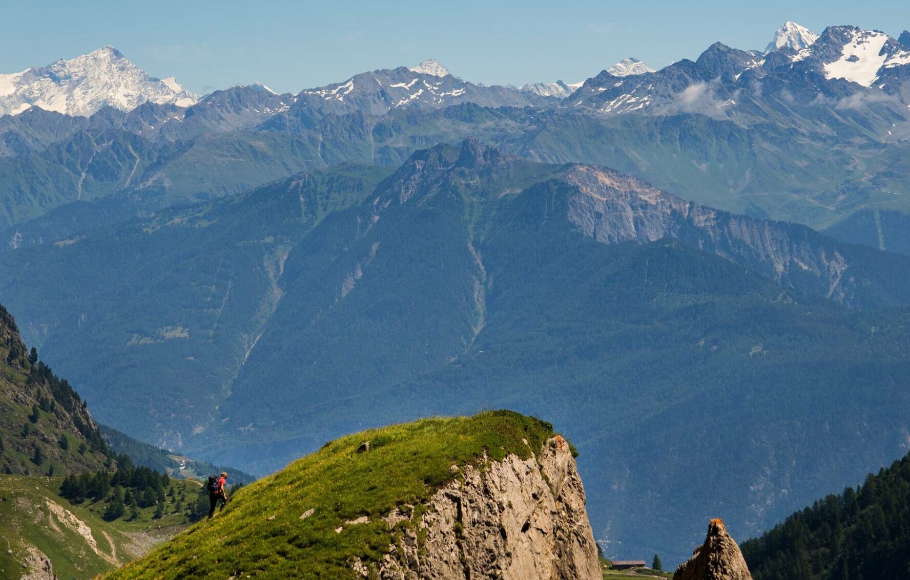
The ultimate hike including glacier crossing in the Matter valley – home to the highest peaks in the Alps and surrounded by imposing glaciers.

- Type Multi-day hike
- Difficulty hard
- Duration 22,00 h
- Distance 54,2 km
- Ascent 2834 m
- Descent 3512 m
- Lowest point 1605 m
- Highest point 3158 m
Description
From the Alpine metropolis of Zermatt through larch forests, along various high-altitude trails, past the most beautiful mountain lakes and over the mighty Gorner Glacier to the architecturally unique Monte Rosa Hut. This is the four-day Monte Rosa Trek - a highlight among experts. The start and end of the trek are in Zermatt.
Day 1: Ascent via Sunnegga, Tufternalp to the Täsch Hut at 2,701 m
Day 2: Via the Pfulwe to Grindjesee lake and Grünsee lake to the Mountain Lodge ze Seewjinu at 2,300 m
Day 3: Ascent to the Gornergratsee lake, via Rotenboden and glacier trekking over the mighty Gorner Glacier to the Monte Rosa Hut at 2,882 m
Day 4: Glacier trekking over the mighty Gorner Glacier and via Rotenboden, Riffelsee lake, Dossen and the suspension bridge Furi back to Zermatt
We recommend:
- Good footwear
- Hiking poles (optional)
- Clothing suitable for the weather (always carry a waterproof)
- Food and water
Additional equipment for glacier crossings: crampons, climbing harness, 1 rope per group of 4, suitable clothing
The trek can be booked as a package with or without guided glacier trekking (third and fourth day).
- Plan every mountain tour carefully and adapt to participants’ fitness level as well as the weather and season.
- Weather conditions can change quickly in the mountains. Appropriate clothing is therefore essential, along with adequate supplies of food and water. In uncertain weather, turn back in good time.
- Inform others of planned route, and whenever possible avoid going alone.
- Do not leave the marked routes; do not venture onto glaciers without a mountain guide.
- Please be considerate to other walkers and to plants and animals.
- Take note of the warning signs drawing attention to the constant danger in river beds and along watercourses below dams and reservoirs.
Important! This is a demanding alpine trek; stages may include glacier traverses. We therefore recommend the services of a mountain guide with local knowledge.
Tip: “Be searchable”. Equip yourself with an additional RECCO rescue reflector*. Whether summer or winter. Available in our Online-Shop or our information desk.* The additional reflector does not replace an avalanche beacon.
Map and arrival
The matterhorn trek.

Private ski and snowboard lessons

Experiences & activites

Gift Vouchers

AGM Zermatt Tourism: A magical financial year

Zermatt Tourism takes part in the biggest night in Hollywood

Grow beyond yourself with the Mammut Mountain School

Tips of the day

Room / Appartment 1
Room / Appartment 2
Room / Appartment 3
Room / Appartment 4
- Best Hikes In The World
- Appalachian Trail
- European Hikes
- Nepal Hikes
- Patagonia Hikes
- See All Hikes
- Mount Kenya
- Mount Kilimanjaro
- Mount Toubkal
- See All Mountains
- South Africa
- New Zealand
- Switzerland
- United Kingdom
- Packing Lists
Tour de Monte Rosa – A Classic Alps Hiking Route

Europe , Hikes , Italy , Switzerland

With ten peaks reaching higher than 4,000 meters, the Monte Rosa massif is one of the most impressive in the Alps . It is fair to say that the 9 day Tour de Monte Rosa trek, around the massif, is one of the best hiking routes in Europe .
The hike provides an epic mixture of awesome mountain-scapes across two great European states.
From hushed mountain passes to green valleys dotted with wooden Swiss Chalets during the first half of the hike, to the tranquility of remote Italian mountain villages during the latter stages of the trek, the Tour de Monte Rosa provides a great alternative to the Tour du Mont Blanc .
But do be aware, despite being one of the most scenic treks in the Alps, the route is strenuous , particularly the 3,295m high crossing of the Theodul Pass!
Join a Matterhorn Highlights Hike
Book with our recommended local guide
Tour de Monte Rosa Overview
The Tour de Monte Rosa is a long, multi-day hiking trail covering a total distance of 162 kilometers and gains more than 13,000 meters of altitude over 8 to 10 stages.
The highest point reached on the hike is 3,295 meters.
Most people start their hike in Täsh, Switzerland going in an anti-clockwise direction. Resting just to the east of the Matterhorn, the stunningly beautiful Monte Rosa is situated at the border between Switzerland and Italy .
The Tour de Monte Rosa provides a perfect opportunity to experience the different valleys in both countries.
On the circular hike you will pass some heavily glaciated areas, be afforded many scenic views of the highest peaks in Switzerland and take on some of the highest mountain passes in the Alps. The route will bring you to famous towns such as Zermatt, Aosta and Saas Fee, while crossing the notorious Europaweg.
You may also like : hiking in Switzerland
Tour de Monte Rosa Pros & Cons
Here's what we like and dislike about the Monte Rosa hike.
- Incredible views of the Monte Rosa massif and the Matterhorn
- Hike in two countries - Switzerland and Italy!
- Walk the amazing Europaweg between Grächen and Zermatt - this route is considered by many to be the most beautiful 2-day hike in the Alps
- Spend the night in some of the most famous European mountain huts
- More expensive than standard camping hikes due to the use of mountain huts
- Physically challenging, not for the faint-hearted
Monte Rosa Hike Route Map
This map illustrates the Tour de Monte Rosa.
Most people start their hike in Täsh or the Saas Fee.
The route is normally done in an anti-clockwise pattern but if you want to make the route a little easier then a clockwise plan is better as the ascents are more gradual.
You will need to cross Theodul Pass (3,295m), which is one of the highest passes in the Alps.
For an excellent guidebook and map we recommend Hilary Sharp's The Tour of Monte Rosa: A Trekker's Guide .
Monte Rosa Trail Altitude Profile
In the chart below you can see the altitude profile of the full hike. It is quite clear there is a lot of altitude to be gained over the stages. The heighest point is 3,295 meters. You can see that there are a few strenuous stages reaching high mountain passes that will require great effort.

This profile was produced by Trace de Trail and shows the altitude profile for the hike as well as the ultra marathon!
Tour de Monte Rosa Itinerary
Below we have laid out the most popular version of the Tour de Monte Rosa route – 9 days, starting and finishing in Saas Grund. The itinerary includes approx. distances, hiking times and elevation changes.
Day 1: Saas Grund – Macugnaga
Ascent: 650m Descent: 1500m Hiking time: 6-8hrs
The Monto Moro pass sitting at 2,853m is your first major col of the journey. Soon after you will reach the Italian part of the trip. Cameras will be much used since you will have great views of the Monte Rosa massif and an impressive look onto the Macugnaga wall.
Day 2: Macugnaga to the Rifugio Pastore
Ascent: 1450m Descent: 1300m Hiking time: 7-8hrs
A great route over the Colle del Turlo while you reach the valley of Alagna. The Monte Rosa will be out of view, but not for long.
Day 3: Alagna to Col d’Olen
Ascent: 1750m Descent: 560m Hiking time: 7-8hrs
A lot of altitude gain today, since you will need to reach Bocetta delle Pisse before descending to Alpe Pianlunga. You can spend the night at a rifugio close to lake Gabiet.
Day 4: Col d’Olen to Resy
Ascent: 1050m Descent: 1300m Hiking time: 6-8hrs
When you reach the Gressoney valley you will truly feel yourself in the Italian Alps. Enjoy an Italian coffee while admiring the impressive Monte Rosa. But don’t depart too late, since there still is an ascent to complete before reaching the refuge at Resy, which is a stunning location.
Day 5: Resy to the Matterhorn!
This is one of the highlights of the trek as you begin with a wonderful traverse towards the meadows of Alpe Varda and Alpe Mase. Soon you will gain views of the Breithorn while you’re climbing towards the Colle Superieur delle Cimes Blanches 2982m. From the top of the pass you gain first views of the Matterhorn, 4478m. After a short descent, your ascent continues to Theodul Pass at 3295m, where you spend the night.
Day 6: Theodul Pass – Zermatt
Descent: 1700m Hiking time: 5hrs
An easy day since all you need to do is descend. Your day starts with the crossing of the glacier before passing Gandegg and on towards the Mattertal.
Day 7: Zermatt to the Europahutte
Ascent: 850m Descent: 300m Hiking time: 6hrs
A pleasant start to the day since you head down the Mattertal before climbing steadily alongside the Europweg, a high mountain route. Be careful of rockfall, since this is unstable terrain. Spend the night in the Europa hut.
Day 8: Europahutte to Grachen
Ascent: 500m Descent: 850m Hiking time: 6-7hrs
Your hike along the Europaweg continues by crossing boulder fields with stunning views.
Day 9: Grachen to Saas Grund
Ascent: 1300m Descent: 1200m Hiking time: 6-7hrs
Even though it’s the last day of the Tour de Monte Rosa, you will finish in style, since this is one of the most stunning paths in the Alps.
Monte Rosa Hiking Video
A beautiful video overview of the Tour de Monte Rosa by valsesiaincoming1 .
Tour de Monte Rosa FAQ
When is the best time to trek the tour de monte rosa.
The best time to tackle this high-level trek around the Monte Rosa massif depends on the amount and timing of the previous winter’s snowfall and the onset of cold weather in the autumn.
Since the route crosses high passes (Theodul at 3295m), snow can create dangerous conditions. Therefore in a normal year it is not advisable to set out before early July .
In the summer months, July and August, the trail is busiest, temperatures can rise to 25 degrees, but thunderstorms or a dump of snow is possible as well.
By the end of September huts will close and it might get a lot harder to complete the trek.
How much does the Tour de Monte Rosa trek cost?
Guided trekking tours of the Tour de Monte Rosa will cost in the region of $1,500-$2,000.
This will include mountain hut accommodation, food throughout the trek and luggage transfers between each stage, which will allow you to enjoy the hike with just a small backpack. You will also be accompanied by an experienced guide.
The trek can however be done unsupported. The cost would be in the region of $1,000. A DIY trek would mean carrying more weight in your backpack and some planning of logistics in the weeks / months before.
How difficult is the Tour de Monte Rosa trek?
Hiking the Tour de Monte Rosa is strenuous and demanding. Make sure your are physically and mentally fit for the trek. There are many steep, uphill sections to conquer, with over 13,000m of altitiude gained throughout the circuit. You need to ensure you are in shape for the physical demands of this route. Mental fitness is as important and often go hand in hand.
The Tour de Monte Rosa is doable for any fit mountain walkers who are able to hike between 5h and 8 hrs per day for several days in a row.
Please note : there are a few sections where you can use public transport to shorten your hike if you are struggling.
Are permits needed for the Monte Rosa trek?
No permits are required to the Monte Rosa circuit trek.
Is altitude sickness a risk on the Monte Rosa trek?
No, you will not cross passes any higher than 3,300 meter, and since you’re hiking slowly to this altitude, you have more than sufficient time to acclimatize.
Most people don’t feel any symptoms of altitude sickness before reaching 3000-3500 meter. But this is when they haven’t spent enough time acclimatizing.
What gear do I need for the Monte Rosa?
To do a serious hike like the Tour de Monte Rosa you will need appropriate layered clothing, including a warm insulated jacket and a hard shell waterproof layer .
Some comfortable lightweight trekking boots are a must to enjoy this trek, while good waterproofs are essential, not only to protect you against rain or snowfall but to double as windproofs. Since you’ll be crossing passes of more than 3000 meters, gloves and several base / second layers may prove useful. Trekking poles are a good way to not overload your knees and ankles.
If you are hiking unsupported you will need to carry a 50-60L backpack , however, if you plan to join an organised tour then many organisations will often include luggage transfer to your next accommodation in the valley, so you only need to carry a small backpack with some lunch, snacks and clothes.
A good three season, preferably four season sleeping bag is a must!
To help you plan and prepare for your trek we recommend reading our gear section .
Browse more hikes in Europe
See our top European hikes picks, or check out these popular hikes.
- Tour du Mont Blanc
- Walkers Haute Route
- Camino de Santiago Routes
- Cinque Terre Hiking
- West Highland Way Hike
- El Caminito del Rey
- Laugavegur Trail
- Kungsleden Trail
- Rota Vicentina
- Slovenian Mountain Trail
About the author
Mark Whitman
Mark has trekked extensively in Asia, Europe, South America and Africa. He founded Mountain IQ in 2014 with the sole aim to be the best online information portal to some of the most popular mountain destinations around the world. When not writing for Mountain IQ, Mark is out exploring the outdoors with his wife!
Leave a Reply
Your email address will not be published. Required fields are marked
I am wondering if there is a possibility of shortening the trip and what your recommendation would be to do such.
I remember I ended the trek at Staffal (Gressoney-La-Trinité) and traveled with public transport to Milan. I liked the part crossing Theodulpass so my advice would be to follow the route clock-wise towards Zermatt. This would take 3-4 days, so you could hike further along the Europaweg towards Sint Niklaus as well, adding two extra days.
If you have mountaineering aspirations or just want some bragging rights 😉 you can climb Breithorn along the way from Klein Matterhorn. This is an easy 4000 meter peak, which requires crampons and ice axe though, but only takes 3 hours. It gives you awesome views on Matterhorn and Monte Rosa massif.
Hi. Great site. Thanks for offering help. If I fly in to Milan and have 6 hiking days, what are suggested routes? [Beginning August. Dad & Grad (son graduating high school). Fitness – I run marathons, he runs half marathons. We had a great 4 day hut to hut experience in Switz/ Bernese Oberland a few yrs ago.] I assume we can’t do full circuit. Is that right? Thank you!
HI Tagrey, see our answer to Michael Wirth below. Cheers!
Hello! Thanks for the info above. I’m planning on self guided walk in July. I’ve done a lot of hiking but new to the alps. Is saas-fee – Macugnaga a fairly manageable 30km first day? Seems too short to stop at Britannia Hutte after only 10km.
Thanks! Bella
Hi Bella, thanks for getting in touch. I’m not 100% sure as the person who wrote this guide has left Mountain IQ. I recommend checking out this website for self-guided help: https://www.thehiking.club/
We work with local guides to offer great value adventures at unbeatable prices
- Tour of Mont Blanc
- Dolomites Alta Via 1
- Dolomites Alta Via 2
Tour of Monte Rosa
- Tour of the Stelvio
- Tour of the Oisans
- Berner Oberland Tour
- Hiker’s Haute Route
- Tour Beaufortain
- Gran Paradiso/Vanoise
- Other Great Hiking Tours
- Planning Your Trip
Duration: 9 Days
As long-distance hiking tours in the Alps go, this tour is relatively new as it was completed in 1997. This is a 100 mile circuit that goes around the glorious Monte Rosa massif which sits right on the border between Italy and Switzerland. Monte Rosa means Red Mountain and it seems anything but red when you first see it. The name supposedly comes from the rose colored hue that is cast on the mountain at dawn. I love this tour. It’s true that I could say that about every one of the tours on this site, but the Tour of Monte Rosa captivates my heart in a special way. I think it is because you visit several charming Italian valleys and villages that are not overrun with tourists. And you pass through the famed mountaineering resort of Zermatt, one of the most spectacular areas of Switzerland. I have to give credit to the travel author, Marcia Lieberman, for introducing this particular route to me and others in her 1999 article entitled A Comfy Way Around the Mountain. Her route follows trails that avoid some of the slopes scarred by ski runs and some of the more spartan huts and, instead, takes you through villages on the Italian side of the mountain.
Day 0 Zermatt
If ever there is a hiking tour where you want to come early to the starting town for a few extra days of hiking and exploration, this is the one. Zermatt is almost completely surrounded by the high mountains of the Pennine Alps. Monte Rosa is but one of the “big ones”, the others being Dom, Lyskamm, Weisshorn, and the Matterhorn. This is a day hiker’s paradise. If I had to select a dozen of the most beautiful, classic Alps day hikes in all of Europe, two or three of them would be based out of here. There is no vehicle traffic allowed in Zermatt which is another plus. You must catch the train farther down the valley in Tasch to arrive here. There is one big downside to this quaint Swiss town which must be mentioned. It is VERY popular and it is PACKED with tourists. But to help deal with this irritation, just avoid the main street through the center of town where 90% of the day tourists spend their time. Stay at inviting Hotel Bahnhof just across the street from the bahnhof (train station). Switzerland is outrageously expensive but this little hotel is as reasonable as it gets for a nice room. There is also a dormitory on the top floor for those wanting a more budget option. I can recommend restaurant Chez Heini for more gourmet fare and Ross-Stall right next door to Hotel Bahnhof for what I call tasty food. For an easy day hike and wonderful outdoor lunch with views of the Matterhorn, head up the mountain a little ways to the Findlerhof restaurant.
Lunch above Zermatt with views of the Matterhorn
Day 1 Zermatt to Cheneil
Today is more an adventure in lift riding than it is a true hiking day. But what delightful lift riding it is if the weather happens to go your way. Take the Klein Matterhorn cable car up from Zermatt and cross the glacier towards the Italian Testa Griglia lift. It is officially recommended to hire a guide for this glacier crossing. The Mountain Guides Office will suggest that you do so. We checked with a couple of knowledgeable locals who assured us that this was not necessary and we, indeed, found that it was not a technical crossing. You want to make sure to stay on course and not stray into areas that might have crevasses. And you want to watch for skiers at the stage where you cross a ski run. But in less than an hour you arrive at the Testa Griglia lift station. I’m always in favor of taking the lift to avoid a long descent (maybe I can still be doing this when I’m 90 if I’m good to my knees). Two gondola stages on the Italian side will take you down to the ski town of Cervinia. Catch the bus which goes down the valley to Valtournenche where you can hire a taxi for the additional 7 kilometers to Cheneil, a small grouping of old farmhouses on the side of the mountain. This is where you will find charming Albergo Panorama Al Bich and where the true hiking begins. I like to stay here because it is a more serene, charming option than any of the affordable hotels in Valtournenche and it gives you a jump on your climb to the pass the next day.
Day 2 Cheneil to St. Jacques
The path from Cheneil to Colle di Nana is signposted and easy to follow. You reach the col without difficulty and 1000 meters of descent later, you reach the tiny and pleasant hamlet of St. Jacques. This is at the end of the road for the Ayas Valley and the smallest town you will be in for this tour. You’ll see just a few houses and shops and a hotel or two. Enjoy the setting and the sound of the river running forcefully through the middle of town. Stay at Hotel Genzianella. It’s not anything spectacular but definitely satisfactory and provides a good breakfast.
Chapel in St. Jacques
Day 3 St. Jacques to Gressoney St. Jean
Today’s hike actually leaves from the ski resort of Champoluc about 4 kilometers up the valley. Road walking is pretty boring and tiring so catch the morning bus to Champoluc instead. A cable car from Champoluc to Crest will get you another few hundred meters along your path. This is a wonderful stage and not too difficult. Just be aware that the downhill of 1300 meters is a little longer than some. The trail brings you the charming and beautiful town of Gressoney St. Jean, my favorite of the Tour of Monte Rosa. With its cobblestones, flowers along winding streets, and freshly displayed fruits and vegetables outside shops, you will see why I like it so much. Stay at Albergo Alpenrose. Eat in the cozy upstairs dining room of Restaurant Nordkapp.
Day 4 Gressoney St. Jean to Alagna
Today you hike to Alagna, a lovely Walser village. The Walsers were a Germanic-speaking tribe who settled in Switzerland and this region of northern Italy. You will notice the typical Walser architecture of dark wood homes with horizontal wooden slats around the outside for drying hay. Catch an early morning bus to Stafel, a lift station just up the valley. The cable car will take you to the highest station called Passo die Salati where you begin today’s hike, almost all of which at this point will be downhill. I sometimes like to hike the uphill portion of a stage even when a lift is available but today is not the day to do it. A good portion of the ascending trail is dirt road which passes through unattractive terrain used to service the surrounding ski runs. You will have great views of Monte Rosa at the top of the pass. Not too long after leaving the lift you reach Rifugio Guglielmina which makes for a wonderful cappuccino stop. Weather allowing, sit outside on the front deck and take in the views. It also makes for a good lunch spot (reservations recommended because it’s popular for day hikers) but it is hard to justify lunch when the majority of today’s hiking still lies ahead. You have two choices for your descent. You can hike part of the way down to Oltu where a cable car takes you down to Alagna. I would normally not hesitate to recommend this but, in this case, I might suggest hiking all the way down through the Valle d’Otro to the Sesia Valley and the town of Alagna. This hike is so beautiful that I hate for anyone to miss it, even though we are talking about 1700 meters of descent. Consider your two choices carefully because I don’t want you to take my name in vain when you finally reach the valley floor and your knees are screaming. If you happen to be hiking this tour in the opposite direction, I definitely suggest you hike the entire ascent through the Valle d’Otro and then enjoy the long cable car ride down the other side. In Alagna, stay at the stately Monte Rosa Hotel in the middle of town where you will likely be greeted by one of the longtime owners, Peter or Carina. The prices are a little high but the hotel is nice. Eat a wonderful, hearty dinner at Pizzeria Dir und Don. You’re bound to have a good appetite and the food here is varied and tasty. I always opt for the pizza. Make a reservation in order to avoid a wait in the high season.
Making a new friend
Day 5 Alagna to Macugnaga
This is a wonderful stage but also a very long one taking a full 11 hours of hiking time. I believe it is the longest stage of any I have ever done in the Alps so prepare yourself for some very tired feet and legs. A good portion of the path follows an old stone military mule path put in place during World War I. The only way I recommend walking this stage is to get a very early start ( around 6 a.m.) and take a short taxi ride to the end of the road to get a jump start on the long journey. If you decide not to hike this stage you can take a series of buses to Macugnaga but be aware that it takes a good portion of the day and requires a few changes. Stay and eat at the Dream Hotel just a few minutes walk from the center of town.
Day 6 Macugnaga to Saas-Fee
You pass back into Switzerland today and will be grateful to see the cable car which takes you out of the very steep valley almost all the way to the Monte Moro Pass. I don’t find today’s hike to be particularly beautiful but it is interesting. The terrain on the Swiss side is barren and rocky. You descend to the Mattmark dam and then take one of the frequent afternoon buses to Saas-Fee, a pleasant Swiss ski town but one which is always in the shadow of it’s big sister to the west, Zermatt. Saas-Fee, like many other ski towns in the Alps, has suffered from the shrinkage of its glaciers over the last 20 years. For those of us who have been coming to the Alps for decades, the difference is dramatic and sad. It has had a noticeable impact on the beauty of the town as well as the winter tourist economy. Stay at Hotel Tenne and ask for a bed in their dormitory downstairs if you are trying not to bust the budget. It is always a shock to the system to come back into Switzerland and its very high prices after having travelled in Italy. Very outgoing and efficient Emanuella, the long term owner, will hopefully greet you. The breakfast served here is probably the best of the tour. Saas-Fee boasts several very good restaurants these days and they seem to change so check the internet and take your pick. Or if you don’t want to spend too much money on dinner, eat in at Hotel Tenne and order a big plate of rosti, the Swiss version of hash brown potatoes with cheese or ham or other ingredients added in if you wish.
Day 7 Saas-Fee to Grachen
I rate the entire Tour of Monte Rosa difficult primarily because of two stages, the very long day into Macugnaga and today. Today is no where close to 11 hours of hiking but is still long at 7-8 hours. Don’t underestimate the time it takes, especially if you want to catch the chair lift at the end of the day from Hannigalp down to Grachen, saving you a significant 500 meters. The chair lift closes before 5:00 so be sure to check the schedule before you depart. I know this from personal experience, having underestimated the hiking time required and literally jogging, pack and all, the final 30 minutes to catch the last chair. The stage is a classic Alps balcony route meaning you hike along the side of the mountain at a relatively constant elevation with the valley off to one side. It is difficult primarily due to the seemingly endless number of semi-circular contours that you make in the second half of the day. These sections have a bit of exposure. While not at all technical, they do require an even headedness. The hike is stunning and your efforts will be rewarded with beautiful views of the Fletschhorn and surrounding peaks the entire day. Marcia Lieberman calls this stage one of the classic day hikes of the Alps and I agree. If you don’t want to tackle this trail, there is still another hiking option for you today which gets you along in the same direction. Take the early morning bus from Saas-Fee to Saas Grund and hike the balcony route to Gspon. There you catch the cable car down to Stalden where another bus gets you across the valley floor and up the mountainside to Grachen. Yes, it’s a lot of additional transportation for one day’s hike but it might be worth it. This route is also beautiful and doesn’t have the exposure that the former has. It is hard to find reasonably priced lodging in Switzerland but there is a good option in Grachen called the Hotel Garni Abendruh. It is nothing fancy but it is clean, comfortable, and conveniently located. Eat at restaurant Baergji-Alp.
Day 8 Grachen to Europa Hut
The two final stages allowing you to complete this circular tour and finish in Zermatt have only been accessible for a little more than a decade with the opening of the Europa Hut in 1999. Before then, the balcony path from Grachen to Zermatt through the Matter Valley was in poor condition and too long for the average hiker to complete in a day. Now the path, although exposed in parts, is in excellent condition with metal cables where needed and a nice Swiss hut to break the last miles into two reasonable stages.
The Matterhorn
Day 9 Europa Hut to Zermatt
Today is a little less arduous than Day 8. You can enjoy the walk without the added stress of encountering exposed sections. You will see now-familiar Zermatt and the surrounding peaks ahead of you. Hopefully you have already booked at Hotel Bahnhof and perhaps you are starting to taste your upcoming dinner at Chez Heini.
www.tmr-matterhorn.ch/en/home.html
Tour de Monte Rosa Hiking Adventure
June through September
Geneva, Switzerland is less than 3 hours away
11 days (9 days of trekking)
Things to know
There are very few hiking feats in the Alps that could beat crossing the Tour de Monte Rosa. Shared by Switzerland and Italy, this trail encircles one of the most impressive massifs in the Alps, named after the highest peak of both countries: Monte Rosa. Crossing its 100 miles, you will enter a collage of lofty peaks dominating cow-speckled villages and sleep soundly in rustic refuges beneath glaciers. Walk the centuries-old roads taking you to knee-trembling mountain passes before crossing suspension bridges spanning Alpine lakes and forested valleys. After 9 days of trekking and 42,000 feet gained in altitude, finish right where you started—and learn why the Tour de Monte Rosa is considered one of the best hiking routes in the Alps.
Cross a trail that circumnavigates ten +13,000-foot peaks
Experience the world-famous Matterhorn, Zermatt, and Euroweg
Stay in authentic mountain huts immersed in sublime Alpine scenery
Join your guide for 11 days of Alpine bliss in Switzerland and Italy! Cross one of the most demanding—and the most epic—hiking circuits in the Alps: Tour de Monte Rosa. Enjoy incredible scenery with 10 peaks above 13,000 feet, hike in glaciated terrain and stay in rustic refuges and charming hotels in quaint villages and towns, including Zermatt. Relish great food, breathe in some mountain air, challenge your body and recharge your mind—the Monte Rosa massif awaits you open-armed.
Your trip starts in the village of Saas Grund, a walking distance from the well-known ski resort of Saas Fee. Meet your Tour de Monte Rosa hiking guide in the village or in your accommodation in the afternoon, do a gear check, and meet your fellow hikers over dinner. Meals : Dinner

Day 2 starts with a short bus ride to Mattmark, where your group will start gently, following the side of Lake Mattmark. This is a good warm before tackling the first col of your Tour de Monte Rosa hiking trip—the Monte Moro, which stands at 9,360 feet (2,853 m). Enjoy the stunning views of the Weissmies (13,200 ft / 4,023 m) and the Rimpfischhorn (13,773 ft / 4,198 m) peaks. On arrival at the pass, your group will be greeted by Monte Rosa itself. After a steep descent through boulder fields, you arrive in the village of Macugnaga, where you will stay for the night. Meals: Breakfast and dinner Hiking: 15 km (9.32 miles) Altitude gain/loss : +750 m (2,460 ft) / -1,600 m (5,250 ft)

Day 3 features one of the longest climbs of the trek. Start your hiking by following the torrent of Anza towards the lake at Quarazza. Afterward, you will climb steadily through the spruce forests to Alpe Plana, with views of impressive waterfalls behind you. Pass over the Colle del Turlo and enjoy the views of the Weissmies peak once again. From here, your group will have a long steady descent to your overnight stop at the Rifugio Pastore. Meals: Breakfast and dinner Hiking: 23 km (14 miles) Altitude gain/loss : +1,510 m (4,955 ft) / -1,300 m (4,265 ft)

From the refuge, your hiking on the fourth day starts with a climb to the Vallon delle Pisse. The route follows the waterfall underneath the glacier of the Piramide VIincent, one of the smaller peaks of the Monte Rosa Massif. After passing the cable car station at Alpe la Balma, take on a steep and rugged path over the Bocchetta delle Pisse, followed by a descent to Alpe Pianlunga. Another winding ascent takes your group through the Valle d’Olen, then back down to the refuge at Lake Gabiet, your accommodation for the night. Meals: Breakfast and dinner Hiking: 15 km (9.32 miles) Altitude gain/loss : +1,800 m (5,905 ft) / -650 m (2,135 ft)

Your hiking starts more gently today. You will first cross the Colle d’Olen, then descend through the larch forests to the Rifugio del Lys. From here a nice trail through forests and meadows brings your group into Gressoney Stafal. From here, head up to Alpe Sitten, and take a path to the only pass of the day—the Colle di Bettaforca. You will then take an easy trail down to the pretty hamlet of Resy, spending the night high above the Ayas Valley. Meals: Breakfast and dinner Hiking: 16 km (10 miles) Altitude gain/loss : +970 m (3,180 ft) / -1,200 m (3,935 ft)

Day 6 begins with a short descent towards the meadows of Alpe Varda and Alpe Mase—one of the highlights of the trek. Climb steadily to the Colle Superieur delle Cime Blanche (2,982 m / 9,783 ft), with the Breithorn above us. From this vantage point, enjoy your first unforgettable views of the Matterhorn (14,692 ft / 4,478 m). After descending through the glacial moraine, tackle a steep final climb to the highest point of the trip, and your base for the night—at the Colle del Teodulo (10,883 ft / 3,317 m). Meals: Breakfast and dinner Hiking: 18 km (11 miles) Altitude gain/loss : +1,550 m (5,085 ft) / -300 m (985 ft)

Today your group will be joined by an IFMGA qualified guide, as you descend the Theodule glacier (the spelling has changed now since you are back in the German-speaking area!). The group will be roped up, but no other specialist equipment is needed, other than your hiking boots and trekking poles. Enjoy the views of the Matterhorn and other peaks: the Alphubel, Dom, Obergabelhorn, Zinalrothorn, and Weisshorn. At Gandegg, leave the ice of the glacier behind, and descend to the famous mountaineering town of Zermatt—situated beneath Matterhorn. Meals: Breakfast and dinner Hiking: 16 km (10 miles) Altitude gain/loss : +460 m (1,510 ft) / -2,070 m (6,970 ft)

Leaving Zermatt, follow the Mattertal towards the Rhone Valley and stroll through meadows and larch forests. After Täsch, enter the village of Randa, and start a steady climb on a steep zig-zag trail. You will pass under the rugged peaks of the Täschorn and the Dom, before reaching your base for the night: Europahütte, a relatively new hut in a stunning location. The alternative route of getting from Zermartt to Europahütte is along Europaweg, arguably the most scenic two-day hiking trail in the Alps—featuring the longest pedestrian bridge in the world. Meals: Breakfast and dinner Hiking: 16 km (10 miles) Altitude gain/loss : +890 m (2,920 ft) / -300 m (985 ft)

Today your traverse continues across boulder fields, with rugged cliffs towering above, and the Breithorn and Matterhorn behind us. Enjoy stunning views as your group tackles the cables and bridges on this exciting trail. The Riedgletscher lies in our path, so we descend steeply and drop down through the woods to our overnight stop at the village of Grächen. Meals: Breakfast and dinner Hiking: 17 km (10.6 miles) Altitude gain/loss : +600 m (1,970 ft) / -1,180 m (3,870 ft)

On the final day of the tour, you will take the Hohenweg path to Hannigalp, high above the Saastal. This stunning path is a little lower and greener than those covered in the previous days, but still with exposed sections that demand your full attention. Directly ahead, you can enjoy the views of the snow-topped Weissmies, and the Lagginhorn. The Tour de Monte Rosa guided trek comes to an end as your group arrives back where you started: Saas Grund. Take some well-earned rest and celebrate your achievements with your guide and fellow hikers. Meals: Breakfast and dinner Hiking: 21 km (13 miles) Altitude gain/loss : +1,220 m (4,000 ft) / -1,270 m (4,165 ft)

Your tour finishes after a hearty breakfast. Say goodbye to your guide and fellow hikers and go back to the airport—or continue touring on your own. Meals: Breakfast

Meet your guides

I’ve been on seven treks in the Alps, including Chamonix-Zermatt, the TMB, and the Bernese Oberland. I’ve also managed to climb seven of the easiest peaks. The trip that I have enjoyed the most was the 2016 Tour de Monte Rosa led by Emma Jack. The weather and varied scenery were superb (except for day two which was wet and misty). The group was eclectic but friendly and the length and difficulty of the tour just right for me. The accommodation (five nights in hotels and five in refuges) was of a very good standard and was fabulous at the Rifugio Gabiet and at the Hotel Hannigalp in Grachen.
What you get on this adventure:
- An experienced, local hiking guide with extensive knowledge of the area
- Qualified IFMGA guide for the glacier section
- 11-day hiking adventure along the Tour de Monte Rosa (9 days of hiking)
- Accommodation in hotels and mountain refuges
- Meals as indicated in the itinerary
- Transportation from Saas Grund to Lake Mattmark
What’s not included:
- Transportation to and from Saas Grund
- Airport transfers — we recommend Mountain Drop-Offs
- Lunches, drinks, and snacks
- Guide gratuities — optional
- Travel insurance — compulsory (covering medical expenses, mountain rescue including helicopter evacuation, and cancellation)
To join this Tour de Monte Rosa hiking trip, you need to be in excellent physical shape. You need to have a lot of hiking experience in mountain terrain and experience of multi-day treks. Be prepared for 9 consecutive daily hikes with 15 miles (23 km) of distance covered on the longest day. Daily altitude gains will be between 1,510 and 5,900 feet (460-1,800 m). What makes Tour de Monte Rosa different from similar Alpine treks is an obligatory glacier crossing. Keep in mind that you will be followed by a special guide for this section. On regular days, you will take many breaks and will also always be followed by an expert hiking guide who will make sure you are comfortable on the trails.
Here’s a list of the equipment you need to bring:
- Day pack large enough to carry all the items listed (around a 25-40L bag)
- Hiking poles — optional
- Water bottle or hydration bladder (2L capacity)
- Lightweight hiking boots or shoes
- Spare clothes for layering
- Waterproof rain jacket
- Waterproof pants
- Base layers (top and bottom)
- Mid layer—usually a fleece
- Hiking pants (shorts as well if you want)
- Toiletries (sunscreen, hand sanitizer, bug spray, etc.)
- Headlamp or flashlight
- Camera — optional (but recommended)
Dress comfortably and for the weather in clothes you can move in. We suggest bringing clothing appropriate for the season. Layers are best and don’t wear jeans.
During your guided Tour de Monta Rosa trip, you’ll be staying 5 nights at mountain refuges and 5 nights at local hotels. When it comes to hotels, you’ll be staying in private rooms. Mountain refuges, however, have shared rooms and dormitories. Although some of them are quite rustic, the view of the surrounding mountains and their authentic charm makes up for any lack of luxury. Nights spent in mountain refuges might just end up being the highlight of the trip due to unparalleled views and local wildlife. Because of the remote nature of the refuges, there won’t be any luggage delivery during the trip.
Group sizes and prices:
- For this group adventure, the maximum client-to-guide ratio is 10:1.
- It takes a minimum of 4 people for this tour to operate.
- The cost does not decrease as the group grows.
Trekking along the Tour de Monte Rosa can be arranged for larger groups. Contact us to make arrangements.
Min. age requirements:
- If you are older than 18, you’re good to go.
To get to Saas Grund, your starting point, most people fly into Geneva International Airport (GVA) , one hour away. Once you arrive, there are several ways to reach your destination, including public transport.
You will meet your guide at a predetermined location in the village or in your accommodation on day 1.
57hours is committed to providing safe outdoor adventure experiences. We require all guides using our platform to have a COVID-19 safety plan and to make the details of that plan accessible to travelers. In most cases, group sizes will be reduced, guides will avoid overcrowded locations, and other safety measures will be met depending on the location and activity.
We also expect clients to respect local regulations and take measures to protect themselves, guides and the communities they’re traveling to. For more information on COVID-19 measures in the Monte Rosa areas in Switzerland and Italy please refer to Switzerland’s official COVID-19 travel guidelines and Official Italian Tourism Website .
Please contact us if you have any questions or require further information. We are happy to provide you with the most up-to-date information!
A 30% non-refundable deposit to secure your place is due upon booking. The remaining amount is paid 10 weeks (70 days) prior to departure. Once the trip is confirmed by the guide, the cancellation policy stated below applies.
- If Client cancels the Booking anytime prior to seventy (70) calendar days in advance of the trip contemplated by the booking, only the Client’s deposit will be forfeited.
- For cancellations thirty-one (31) to seventy (70) calendar days in advance, Client is entitled to a refund in the amount of fifty percent (50%) of the total price of the trip.
- For cancellations thirty or less days in advance, Client is not entitled to any refund.
- Any reimbursable expenses arising out of the Booking incurred by Guide prior to the date of cancellation (including but not limited to plane tickets, car rental payments, and lodging or transportation fees) are non-refundable as soon as they are incurred by the Guide.
Secure your spot for 2025 with a 10% deposit! This tour gets sold out very quickly, but with early-bird booking, you can rest assured you’ve booked your dream adventure in time.
- Only 10% of the total amount should be paid as a deposit upon booking. This deposit is non-refundable, but can be transferred to another 57hours adventure anytime in case the dates don’t suit you. This can be done by the end of the year.
- Another 20% needs to be paid by the end of this year.
- The remaining balance is due 10 weeks (70 days) prior to departure.
Other things to do in Swiss Alps

Summer Hiking in Switzerland: Via Alpina Tour

Hiking Tour des Combins: The Secret Alpine Route

Hiking in the Heart of the Swiss Alps for 50+ Women

Hiking in Bernese Oberland of the Swiss Alps

Authentic Alpine Hiking: Four Springs Trek in Switzerland

Women’s Luxury Hiking Tour of Via Alpina, Switzerland
View all (19) adventures in Switzerland
Choose a currency
- USD - $ US Dollar
- EUR - € Euro
- AUD - AU$ Australian Dollar
- CAD - CA$ Canadian Dollar
- GBP - £ British Pound Sterling
- CHF - CHF Swiss Franc
- JPY - ¥ Japanese Yen
- SGD - S$ Singapore Dollar
- HKD - HK$ Hong Kong Dollar
- DKK - Dkr Danish Krone
- NOK - Nkr Norwegian Krone
- SEK - Skr Swedish Krona
Hiking the Tour of Monte Rosa
A 100-mile walk around a huge mountain that straddles the borders of Italy and Switzerland, this Alpine trail deserves to be better known, says Alex Roddie
This article was first published in TGO Magazine , July 2016
There’s something beguiling about Monte Rosa. The name sounds graceful, but the mountain is not – it’s a complex behemoth of glacier and rock straddling the Swiss/Italian border, and one of the highest peaks in the Alps at 4,634m. I’ve long been fascinated by this mountain. Years earlier, when climbing Castor or Pollux, I’d looked up at the impossibly bright snowfields and longed to be one of those ant-like figures crawling towards the summit.
Over in France, the famous Tour du Mont Blanc is a backpacking trail encircling the Mont Blanc massif. When I heard of a similar 100-mile route offering a 360° tour of Monte Rosa, I knew this was the trail for me.
I thought I had a pretty good idea of what to expect when I started my hike one sunny morning from Zermatt, but I soon discovered that the Tour of Monte Rosa is full of surprises.
The first came in the form of a big, scary sign warning of rockfall on the trail. The Europaweg, a high-level path from Zermatt to Grächen, has a gnarly reputation – but I just shrugged and asked myself ‘how bad can it be?’. The views down through unspoiled forests of larch and pine to the valley far below were stupendous, and every few minutes I’d turn around to gape in awe at the Matterhorn’s pinnacle thrusting up through the clouds and dominating the scenery in every direction. But after Täschalp things became more dicey. The weather closed in, and I found myself climbing ever higher into a wasteland of boulders and shattered gullies where nothing grew. The trail was exposed to stonefall for long stretches and it was unnerving to hear rocks crash and tumble through the mists, sometimes out of sight, sometimes shockingly close to hand.

Then came the next surprise: a diversion to avoid a wrecked bridge across a gully. 750m back down, almost to the valley floor, then steeply back up again to the Europa Hut at 2,265m. I was quickly learning that a key feature of the TMR is its relentless gradient profile.
The Europaweg Hut was full, so I pressed on in the hope of reaching Grächen before dark. But my progress slowed as the trail became even sketchier underfoot. I found myself benighted and looking for somewhere flat to camp, eventually choosing marginal perch on the edge of another gully that rumbled and rattled with landslides all night.

I enjoyed myself a little more after completing the Europaweg. The small town of Grächen is set amongst some of the most beautiful alpine forest I have ever seen. Golden eagles swooped overhead and called to each other on the warm summer breeze, and a passing hiker even claimed to have seen a lynx. Soon I’d turned the great prow of the Mischabel – one of Monte Rosa’s enormous satellite chains – and was hiking south along the Balfrin Höhenweg.
That’s when I started to see ibex. I spotted the first leaping expertly from rock to rock down the side of a cliff, but an hour later I was treated to the spectacle of two bucks battling it out only a short distance away. The clash of their horns echoed through the forest. It was a special moment. Traffic buzzed along the road a thousand metres below, and nothing moved in the sterile world of ice and rock above; but here, surrounded by the colours of late summer, everything felt just right.

Ups and downs
So far, Monte Rosa itself had been conspicuously invisible. I’d hiked deeper into Switzerland, then back towards Italy; soon I’d cross the border. When would I finally catch a glimpse of the mountain this trail was supposed to be all about?
The Monte Moro Pass, an ancient trade route between Switzerland and Italy, proved to be the key. The Monte Moro Pass reaches 2,853m and is the hiker’s first taste of being amongst the bigger mountains. Early in the summer there’s a good chance snow might lie on the route, but it’s never especially steep and is a popular hike. On the day I crossed, I stepped on snow only once and was so preoccupied with the view back along the Saastal that I hardly noticed the new vista unfolding in front of me – until, that is, I reached the top, and the tremendous East Face of Monte Rosa was visible in all its splendour.
This must surely be one of the best moments of any alpine backpacking route. The East Face is like a Himalayan wall plucked from its homeland and dumped in the middle of Europe. All around, the slopes of lower mountains rise from deep valleys, passing through shades of emerald green before merging to the slate greys of the summits. But Monte Rosa burned with that white-hot intensity I remembered – a jagged monster of a mountain, all complex cirques and hard angles but not without beauty.
And that’s where the trail changed. For the next sixty miles I had col after col to cross, in a relentless game of up and down that had my knees screaming for mercy. I’d studied the map beforehand so had a good idea what to expect, but the reality of climbing and descending up to 2,000m every day was absolutely exhausting – even though the scenery was worth the effort, most of the time.

The TMR became a little less defined in Italy. Suddenly I was faced with choices. Go left down the valley and climb this col, or go right and climb that one? It was a balancing act between total ascent and quality of scenery, and I didn’t always get it right. The Colle del Turlo, following ancient Roman pathways out of the forests of the Vallee Quarazza, was a wonderful section and I enjoyed every moment. But after dropping down to the village of Alagna Valsesia, I started climbing up to the Col d’Olen and got lost in overgrown and abandoned farmland without a path to be seen. ‘Maybe I should have bought the guidebook after all,’ I muttered after losing the path for the fiftieth time.
The pinnacle
I’d been looking for a suitable target for a fly-by peak-bagging mission on my way back towards Switzerland. My map presented plenty of options, but most either required technical mountaineering equipment or were insignificant-looking bumps on satellite ridges. I wanted something better.
One option stood out. Testa Grigia, a 3,315m mountain standing between Val de Gressoney and Val d’Ayas, is said to command unrivalled views of the entire Monte Rosa chain. There’s even a Club Alpino Italiano (CAI) bivouac cabin near the top. The official Tour of Monte Rosa passes to the north, over the lower and easier Comba de Fourcare, but I decided the diversion would be worth it.

A monster day of over 2,200m of ascent saw me climb from the other side of the Col d’Olen down to Gressoney, then back up to the Colle Pinter before making a final loose climb to the Lateltin bivouac hut at 3,132m in the dark. I was exhausted, and it had begun to snow outside, but the cabin had everything I needed: a stove, warm bedding, even food supplies. I settled down for the night and set my alarm for an early start.
I woke at dawn. Ice and a dusting of fresh snow glazed the rocks, and I wondered if the climb would be feasible without winter gear. But when I stepped outside the cabin and witnessed one of the most stunning temperature inversions I’d ever seen, I knew it had to be worth a shot. Cloud boiled a thousand metres below me, and shafts of sunlight cut through the mists to paint delicate pastel colours on the upper slopes of the mountain.

Even with a little black ice here and there, the scrambly ascent was safe in my trail shoes and the early morning sun melted off the snow soon enough. When I reached the summit at 3,315m, the vista over the Monte Rosa chain was everything I had hoped it would be: a grandstand view of one of the highest and best mountain massifs in the Alps, seen at the best time of day and from the best angle. Every summit stood proud and clear against the bluest of skies. Glaciers tumbled in chaos from the snowfields where they formed to the moraine where they melted and metamorphosed into rivers. It was a complete picture of mountain beauty, and the high point of my Tour of Monte Rosa experience.
Tip-toeing back to Switzerland
It wasn’t exactly all downhill after the ascent of Testa Grigia, but I’d broken the back of it. One final pass to go; one final chance to climb up into the mountains before the long descent to Zermatt.
The Theodul Pass is the highest point on the official TMR at 3,295m, and the only place where you have to set foot on a glacier. Until you get to the Cervinia ski complex, the walk up to the glaciated col is a delight: scenic paths through semi-managed woodland, followed by grassed-over ancient moraine that strongly reminded me of the Scottish Highlands. I took my time wandering through this mountain playground before finally camping beside the blue waters of the Grand Lac at 2,806m.
I’d been worrying about the glacier crossing. There’s only a short section of ice before a romp down the ski piste, but I’d heard conflicting reports about how steep the top section might be. Unwilling to carry ice axe and crampons over a hundred miles of hard trail just for one short glacier crossing, I hadn’t packed winter gear.

A freezing wind was blasting over the col as I stepped from rock onto hard-packed ice. The surface hadn’t melted as I’d hoped, and I prodded at it with the tips of my poles to gain purchase. Some other hikers were also about to make the short descent to the ski piste and we chatted about our adventures as they got out their ice axes. ‘We’re just returning from the Tour of the Matterhorn,’ they told me. ‘This is the first time we could have done with having crampons!’ Like me, they had chosen to save weight rather than pack spikes.
We zig-zagged down the glazed surface in single file, kicking and clawing with the edges of our shoes to get some bite, leaning on both poles for support. I would have been happier with some Microspikes – or just a slushy surface to allow me to kick steps – but in a few minutes we were off the slope and onto the well-groomed surface of the piste where the walking was easy.

The views on the walk back down to Zermatt were superb. Beyond the peak of the Riffelhorn, at the head of a distant glacier, lay Monte Rosa once again. I’d now seen this iconic massif from every angle, come to appreciate its different moods. But the variety of Monte Rosa extends far beyond its contrasting faces. Every valley I had crossed on my journey could trace the source of its rivers to the ice of Monte Rosa. Every pass straddled one of its satellite ranges, like the limbs of an octopus. To see the whole mountain, to truly understand it, you have to do more than climb from the bottom to the top – you have to stay out a little longer.
Photographic notes
I used the Fujifilm X30 fixed-lens compact camera for this trip. Despite its small sensor, the camera performed well in a variety of conditions and the excellent zoom lens was a real benefit. I did not, however, attempt any night-time photography – it would have been impractical.

- Share on Twitter
- Share on Facebook
- Share on LinkedIn
- Share on Pinterest
- Share via Email

Alex Roddie
Happiest on a mountain. Writer, story-wrangler, digital and film photographer. Editor of Sidetracked magazine (I make the words come out good).
Alex Roddie Newsletter
Join the newsletter to receive the latest updates in your inbox.
Related Posts
The second chance.
For someone who grew up in the flatlands and was only able to get to the hills occasionally, the dream of living in the mountains was always a seductive one. My first chance came in 2008 when I was 22 years old. In 2008, I was uncertain about a lot
An overnighter in the Cairngorms with David Lintern
Here are some pictures from a recent short weekend in the Cairngorms with David Lintern. I've worked with David for many years on countless projects, and across multiple publications – he actually published some of my earliest professional outdoor writing, and I owe him a lot. But we'
Home scanning 35mm film, the quest for cheaper analogue photography, and bringing the past back to life
Getting into the details of my own analogue revival.
- Who are we?
- Snowshoeing
- Vias Ferratas
- Skimo, Freeride & Heliesquí
- Luxury & Comfort Trips
- White mountains
- Bank holidays
- Information
- Mountain Happy Day
- Additive Plus+
- Survival Experience
- Incentive Trips
Crossing of the High Route of Monte Rosa
Crossing the high route of monte rosa.
The main mountain range of the Alps is a hydrographic divide that is located on the border between Italy and Switzerland. In the East, the Monte Rosa massif and to the West alone, the Gran Combin. In this long Program, mountaineers will have a long stay at altitude without descending to the Valley and traveling the long and extensive line of 4000. During the route you will be able to ascend many 15 of the 18 mountains that exceed 4,000 meters of this impressive massif. A fabulous experience for lovers of mountain skiing and classic mountaineering, being able to ascend the second highest mountain in the Alps, Punta Dufour, at 4,633 meters.
Trip details
Available dates.
From March to May.
7 days of travel, 5 days of crossing
From 4 to 8 people.
Accommodation
Hotel on the first day and the rest excellent mountain refuges that have almost all the comforts, especially the Swiss ones renovated during the last decade and that stand out for the use of cutting-edge sustainable materials.
Difficulty level
Medium. Good physical condition to face slopes of up to 1,300 meters and descents of up to 2,200 meters. A good cramponing technique and some use of the ice ax on terrain that does not exceed a 45º slope in snow or ice.
Personal equipment
Head : Warm hat Sun cap Factor 4 protection sunglasses. Snow goggles (ski type)
Body: Thermal underwear (recanvis for several days) Long-sleeved thin fleece-type layer. Warm layer such as thick fleece or primaloft or down. Waterproof nylon or Goretex type layer.
Legs: Thermal meshes Comfortable softshell type touring ski pants. Waterproof nylon or Goretex type pants.
Hands Some thin fleece gloves. Warm waterproof gloves or mittens. Inside the backpack: Personal documentation. (in a waterproof bag), 1 water container of at least 1 liter, 1 thermos for hot tea. (optional) Individual mini-kit: sun cream, lipstick, plasters + “double skin” (2nd skin), paracetamol tablets, eye drops, throat lozenges, balls for ears, personal medications.
Shelters Some sack sheets are mandatory. Front with batteries. For personal hygiene. Sun cream. Snacks for the day during the various days.
Technical material
Warm mountaineering boots Telescopic poles (optional) Grampons Traversing ice ax Climbing or rando harness Helmet
DAY BY DAY ITINERARY
DAY 1: Arrival in Zermatt. Night in Gite.
DAY 2: Klein Matterhorn Cable Car 3,883m – Breithorn 4,165m – Pollux 4,091m – Ref.Guide Val D´Ayas 3,380m
From the upper station of the Klein Matterhorn cable car (3,883m) we ascend to one of the most famous and accessible 4000’s in this part of the Swiss Alps, the Breithorn (4165m). Next, and thanks to our skis, we travel in just 30 minutes of gentle descent to the base of the Pollux somital pyramid to ascend this mountain, now with crampons and ice axes on steep slopes of snow or ice. To reach the top we will have to overcome the vertical and aerial chains strategically equipped to facilitate the arrival to this mythical mountain. Once at the base we will put on our skis and descend without further complications to the cozy Guide Val D’Ayas shelter.
Ascent:+ 400m Descent: -800m
DAY 3: Ayas Refuge (3380m) – Castor (4200m) – Quinito Sella Refuge (3450m)
Leaving the refuge very early we will climb Castor along its western slope to reach its summit through one of the sharpest and most impressive edges of this journey and descent to the Quintino Sella refuge.
Ascent: 900m Descent: 800m
DAY 4: Ref. Quintino Sella 3,585mm – Naso de Liskam Pass 4,130m – Piramide de Vincent 4,215m – Ref. de Montova 3,497m
From the Quintino Sella Refuge we will overcome with the use of ice axes and crampons the famous and sometimes delicate due to the presence of ice, the Naso del Liskam Pass (it is the most technical pass of the journey). Once passed, we will head towards the Mantova or Gnifetti refuge, having the opportunity to ascend Vincent’s Pyramid (optional) shortly before arriving at the refuge.
Ascent: 900m Descent: 1,100m
DAY 5: Day: Ref. of Mantova or Gnifetti 3,497m – Col de Lys 4,246m- Monte Rosa 3º Punta Zumsteinspitze 4,573m – Ref. of Monte Rosa 2,795m
During this stage, if strength and time allow us, we can ascend to numerous 4000 s such as the Schwarzhorn or Corno Nero (4,321m) – Ludwigshoe (4,341m) – Parrotspitze (4432m) – Signalkuppe (4,554m) and of course the icing on the cake. of the cake of this journey and one of the 3 points that make up Monte Rosa, the Zumsteinspitze point of 4,563m, the highlight of this ski trip. After an impressive descent down the Grenzgletsher glacier and night in the last refuge, now entirely in Swiss territory.
Ascent: 1,100m Descent: 1,800m
DAY 6: Monte Rosa Ref. 2,795m – Riffelhorn 2,927m – Zermatt 1,600m
From the Monte Rosa refuge we will cross Gorner Glacier to ascend the Riffelhorn with impressive views of Zermatt and the Macugnaga Valley. From here we will descend to the Gornergrat station and continue skiing to Zermatt (if the snow allows it)
End of the journey and final celebration dinner in Zermatt…
Ascent: Om or 500m if we go to Gornegrat Descent: 1,400 m
DAY 7: Return to Spain or place of origin
ADDITIONAL INFORMATION
Services included.
High Mountain Guide Services UIAGM Reservation Management Accommodations in the Valley Accommodations in Chamonix with half board High mountain refuges Cable cars and interior transport Accident Insurance Liability Insurance Collective safety material Complete diets for the High Mountain Guide Transportation by car through the Valley Gift from Manaslu Adventures
SERVICES NOT INCLUDED
Trip to Switzerland Picnics or meals outside the half-board shelters. Meals in the valley. Everything that is not included in the included services section.
PAYMENT METHODS
Payment of 40% of the total amount as payment and deposit. The rest of the amount, 20 days before the first day of the trip.
Transfer: Santander Bank ES86 0049 3079 80 2114287700
RESERVATION AND CANCELLATION POLICY
You can find out our reservation and cancellation conditions through this LINK .

Previous Tour
ADD ANY COMMENTS YOU WANT!
Manaslu Adventures, SL CIF B66726795 Agencia de Viatges GC-004470 Dr. Roux 51 08017 Barcelona
Training Top destinations Customized trips Contact us Legal notice Privacy policy Cookies policy Trip reservations and cancellations Training reservations and cancellations
Covid19 health measures
Más información
Formación Destinos Top Viajes a medida Contactar Aviso Legal Política de privacidad Política de cookies Reservas y Cancelación de Viajes Reservas y Cancelación de Formaciones
Medidas sanitarias Covid19
If you want to live unique experiences in the mountain and enjoy our advantages
- Vías Ferratas
Use of Cookies
This website uses cookies to give you the best user experience. If you continue browsing you are giving your consent for the acceptance of the aforementioned cookies and the acceptance of our cookie policy .
Uso de cookies
Este sitio web utiliza cookies para que usted tenga la mejor experiencia de usuario. Si continúa navegando está dando su consentimiento para la aceptación de las mencionadas cookies y la aceptación de nuestra política de cookies .
What mountain sport are you interested in?
Hiking the Tour de Monte Rosa
Learn about the historic roots of the Tour de Monte Rosa hiking route, a gorgeous and wild loop from Zermatt through Italy around Switzerland’s tallest mountain.

Multi-Country hut-to-hut hiking on the Tour de Monte Rosa
Walking the Tour de Monte Rosa (TMR) route through Italy and Switzerland, an unfolding gallery of panoramic mountains, quaint villages, and idyllic streams greets your eager eyes. Perfectly set stone trails seem to exist just for the enjoyment of hikers. It might be hard to imagine walking along this sweeping path with an enormous load of salt and spices on your back. But, in fact, that is exactly the use these “roads” were originally built to serve.

A Brief History of the Hiking Route
The Monte Moro Pass was once a local trade and seasonal migration route for the Walser people, some of the region’s most influential inhabitants. Walser refers to people from the upper Valais region (or Wallis in German) who had a long history of migrating to uninhabited areas, building new communities, and spreading their language, culture and lifestyle to many areas in the Alps. You’ll notice the Germanic flavor to settlements even on the Italian side of mountains. The trail over Monte Moro was forged as a mule trail for traders crossing between these 2 valleys.
Today, the Madonna delle Nevi (Madonna of the Snow) watches over the pass. She was placed in 1966 and is a popular destination for many local Catholics during the feast days in early August. This small area is popular for both skiing and hiking, with local lifts from Macugnaga that make access easy. Its proximity to the Italian Lakes District also makes it a popular destination for Italians looking to exchange big city hustle for the ease of smaller mountain villages.

Further west, the Theodul Pass linking Italy’s Aosta Valley and Switzerland’s Valais Canton historically served as a bridge for resources, religion, and politics. Sometimes it even meant survival when the strain on resources grew with populations in both areas. The pass remains a formidable obstacle for those traveling across the border between Zermatt and Cervinia, with a crossing of the Theodul glacier still necessary. But crossing the Theodul will soon be much easier. A new cableway connecting the Matterhorn Glacier Paradise station and the Testa Grigia station above Cervinia is in the works. Skiing has replaced the trading of goods. But the pass still remains an important link between the people and economies of the region.

Hiking the Tour de Monte Rosa Today
The convenience of modern travel makes access to the Alps fairly straightforward. The trails surrounding the Monte Rosa massif still serve as the most direct path of travel between the remote valleys you’ll visit here. Trading may be done a little differently now, but these paths are still well-used. For hundreds of years, they have held up extremely well and are still traveled much like they were back then: on foot.
Are you looking to explore this route? Check out our Private Guided Tour of Monte Rosa .
- Switzerland ,
Sign up for our newsletter!
Add your contact info below so we can stay in touch with you!
- Name * First
- Phone This field is for validation purposes and should be left unchanged.

- Privacy Overview
- Strictly Necessary Cookies
This website uses cookies so that we can provide you with the best user experience possible. Cookie information is stored in your browser and performs functions such as recognising you when you return to our website and helping our team to understand which sections of the website you find most interesting and useful.
Strictly Necessary Cookie should be enabled at all times so that we can save your preferences for cookie settings.
If you disable this cookie, we will not be able to save your preferences. This means that every time you visit this website you will need to enable or disable cookies again.
High Altitude Tour | Spaghetti Tour | Crossing of the Monte Rosa Massif at over 4000m with Mountain Guide
A week of mountaineering with many 4,000 metre peaks, imposing glaciers, high mountains and fine pasta in Italian huts

The highlight of this tour is spending a whole week in the gigantic high mountain world. You will travel on the jagged glaciers and experience up to ten mountains over 4000m high. You cross the Monte Rosa massif from hut to hut and finally spend the night in the highest hut in the Alps, the Capanna Margherita. A joint tour that you will remember for a long time!
The Spaghetti Tour is an impressive week of high-altitude touring. You cross many 4,000 metre peaks on huge glaciers in a really cool atmosphere. You start from Zermatt along the Swiss-Italian border and experience the high mountains to the full in 5 days. You spend the night in Italian huts with primi and secondi, which is where the name "Spaghetti Tour" comes from. This tour is rightly popular. It leads past the highest mountains in Switzerland and the glacier landscape is simply gigantic. You often walk on the glacier. There are passages where you walk up a somewhat steeper snow flank, which is secured by the mountain guides, or you scramble up short sections of easy terrain. Just right for you if you have already had your first experience of mountaineering.
Summit destinations
- Breithorn 4164 m or Pollux 4092 m
- Castor 4228 m
- Passo del Naso 4100 m
- Corno Nero 4321 m
- Balmenhorn 4215 m
- Vicent Pyramid 4215 m
- Ludwigshöhe 4341 m
- Parrot tip 4432 m
- Signaluppe/Capanna Regina Margherita 4554 m
- Zumstein Peak 4563 m
Tour schedule
- Ascent 350 metres in altitude
- approx. 2 hrs.
- approx. 3 ½h
- Descent to Rifugio Val d' Ayas 3394 m in approx. 2 ½ hrs and 750 m altitude difference.
- Ascent 800 metres in altitude
- approx. 3-4 hrs.
- Descent 650 metres altitude
- approx. 2 h (650 m)
- Ascent: 1000 metres altitude
- approx. 5-6 hrs.
- Descent 800 metres altitude
- 2 hours to the Gnifetti Hut.
- Ascent: 1200 metres altitude
- Descent 1600 metres altitude
Important info
- Meeting point is at 9.15 a.m. right at Zermatt station.
- The meeting point is easily accessible by public transport. If you arrive by car, you have to park it in Täsch and travel the last part to Zermatt by train. Zermatt is car-free.
- Group size: 2 guests per mountain guide. We will be together with two to three groups depending on the request.
- Additional costs arise from the personal journey, the journey to the small Matterhorn (50.- CHF with half-fare card) and the overnight stay in a hut with half-board (80 - 100 euros) plus personal consumption.
- It is advisable to acclimatise before the tour. We recommend travelling to Zermatt the day before, doing a short hike and spending the night in Zermatt. Alternatively, you can spend the night before on one of the Alpine passes to acclimatise a little.
- Feasibility: We will inform you shortly before the tour how we will conduct the tour.
- Contact for questions before the tour is your mountain guide Jonas: 079 452 33 72
Requirements
- First experience with high altitude tours
- First experiences with crampons and ice axe.
- Fitness for a touring week at 4'000m with 800 - 1200m ascent and descent each time
Packing list and packing tips
- We have for you a detailed packing list with packing tips compiled for you. You can also download these compact Download as PDF .
- It is important on this tour that you only pack what is necessary. We carry our backpack with us for five days. We can buy some food in the huts. Bring enough Euros to pay for your consumption and overnight stay in the Italian huts.
Costs and services
- CHF 2290.- including planning and realisation with mountain guide and advance payment for the hut reservation.
- In addition, the overnight stay with half board costs approx. 80 to 100 euros per night in an Italian hut. Plus the share of the half board and consumptions of the mountain guide. Deposits for reservation are included.
- Excluding travel costs, train tickets (small Matterhorn) and personal consumption.
- Group size of 2 guests per mountain guide:in
- We deliberately go with a rope team with 2 guests. The last few years have shown that the tour is no longer safe with 3 guests. The flanks become steeper, snow passages become icy and ridges become sharper. The conditions on the Spaghetti Tour are becoming more demanding every year. In a three-man rope team we can belay and coach better and remain flexible. With 2 guests, additional summits with short climbing passages, such as the Pollux, are possible.
If you have any questions, please feel free to contact us, preferably directly at Jonas or Florian or via the Contact form .

So come with us on the spaghetti tour:
19 - 23 June 2024, Wednesday - Sunday, 5 days
Still 2 free places

3 - 7 July 2024, Wednesday - Sunday, 5 days
Still 1 free place

17 - 21 July 2024, Wednesday - Sunday, 5 days

31 Jul - 4 Aug 2024, Wednesday - Sunday, 5 days

14 - 18 August 2024, Wednesday - Sunday, 5 days
Waiting list

28 Aug - 1 Sep 2024, Wednesday - Sunday, 5 days

Similar offers:
Spaghetti tour with skis.
Still 3 free places
Spaghetti tour light
24 - 28 July 2024, Wednesday - Sunday, 5 days
Still 5 free places
7 - 11 August 2024, Wednesday - Sunday, 5 days
Questions and answers about the Spaghetti Tour ?¿
What is the spaghetti tour.
The Spaghetti Tour is a traverse of the Monte Rosa massif. Depending on the route chosen, the tour leads over 10 to 18 4,000 m high mountains and runs mostly along the Swiss-Italian border. You spend the night in Italian huts with primi and secondi and often eat spaghetti, hence the name "Spaghetti Tour". This is probably no longer politically correct, but it has become customary.
What is the Spaghetti Tour light?
The Spaghetti Tour light is the easiest version of the tour. It skips some of the peaks. The light variant leads after the Breithorn over the southern valleys with the help of chairlifts to the Mantova Hut. The part around the Castor and Naso is skipped. On this map section, you can see the route of the Bergschaft in red and the light variant in orange. The passages with the lifts are marked in yellow.
How do you prepare for the spaghetti tour?
Getting used to the crampons is a good preparation. You are often on the move on crampons for a long time, so it is pleasant if you already know how to use them. It is also important to acclimatise a little beforehand. It is best to go hiking at altitude the weekend before the tour week. It is also worth travelling to Zermatt the day before the tour or spending the night on one of the Alpine passes. The Klein Matterhorn Bahn takes you up to 4,000 m in no time, so you'll be glad if you're already somewhat acclimatised.
Is it recommended to do the spaghetti tour with a mountain guide?
The mountain guides of Bergschaft know the Monte Rosa massif well and can tell you a lot about the area. If there is bad weather, the mountain guides can adapt the tour and carry out alternatives and thus make the tour week safe and exciting. We also take care of all the organisation and planning. You can come along and be enriched by a grandiose, shared experience.
If you are familiar with large glaciers, can assess the dangers and risks of the mountain world and enjoy planning and carrying out the tour yourself, you can also experience this tour without a mountain guide.
What are the key points of the Spaghetti Tour?
The key sections of this variant are above all the crossing of the Naso and Castor. Due to global warming, the Naso is becoming increasingly dry earlier and the ascent is often icy. The crossing of the Castor requires surefootedness and a head for heights. This is a narrow firn ridge where caution is required. Global warming is affecting the glaciers and increasing the dangers from glacier breaks, seracs and crevasse falls. Our mountain guides are aware of these dangers and pay special attention to these areas.
What is the Spaghetti Tour record?
There are always top endurance athletes who complete the Spaghetti Tour in record times. In the summer of 2020, for example, Adrian Zurbrügg and Nicolas Hojac completed the tour from the Monte Rosa hut to the Klein Matterhorn in a good 14 hours. We take 5 days to do this. Before that, the record of Ueli Steck and Andy Steindl was a good 14 hours. The rope teams are often rope-free.
What equipment is needed for the Spaghetti Tour?
For the Spaghetti Tour, you need the normal High altitude touring equipment .
How many metres of altitude do you cover on the Spaghetti Tour?
The altitude difference of the entire tour with 18 peaks is just under 4500 m. In our variant, we will climb 3700 metres in altitude and descend 4700 metres.
Can you do the Spaghetti Tour on skis?
Sure! The Spaghetti Tour with skis is also a great tour. It is important that the glaciers are well snowed in, but otherwise nothing stands in the way.
What maps do you need for the Spaghetti Tour?
For the tour you need map sheet 1348 from Swisstopo.
Routes and passages
Alpine paradise
Route options
Monte rosa dufourspitze 4634m.
The Monte Rosa Dufourspitze is the highest peak in Switzerland. It is the second highest peak in the Alps.
In both summer and winter this is one of the most demanding high-altitude tours in the middle of the imposing Monte Rosa mountain range.
Variations: Via the Cresta Rey Grad ZS or as a crossing to the Zumstein (4563m) then to the Signalkuppe 4554m (Margherita Hütte) or as a combination together with the Nordend.
Nordend 4609
There is a possibility to hike up to the summit or ski tour over the Silbersattel to the top. The Nordend is seen to be in the shadow of its neighbor the Dufour. In winter there is a possibility to ski down the Monte Rosa Glacier, it is a wonderful ski run. S+, 5-7h Variations: Via the Cresta Santa Caterina (NO ridge), SS

Zumsteinspitze 4563m / Signalkuppe 4554m (Margherita Hütte) / Parrotspitze 4434m / Ludwigshöhe 4342m / Schwarzhorn 4321m / Balmhorn 4167m / Vincentpyramide 4215m
This is an easily accessible summit with a climb over the Grenz glacier. Several summits can be combined in one day.
Overnight accommodation is available in the Margerita hut (highest hut in Europe) or in the huts on the Italian side (Gnifetti or Mantova).
Lyskamm Ost 4527m and West 4479m
This is one of the most beautiful crossings in the Alps. This route is suitable for climbers in good physical condition. It is also possible to climb the eastern summit only. During the crossing, you can stay in the Quintino Sella hut.
SS, 6-8h for the eastern summit, 8-10h for the crossing
Variations: north wall of the eastern summit.
Haute-Route
The Haute Route connects Saas Fee with Chamonix. This seven-day ski tour is a must for any ski touring fan. For the past couple of years the route has been open in summer and includes glacier trekking.
Jägerhorn 3970m
Beautiful tour in wild surroundings and a nice climbing route to the summit.
Cima di Jazzi 3803m
This is an easy ski tour with a beautiful descent over the Findel Glacier to Zermatt.
It is often an option after a big touring day to get you
back to Zermatt.
Castor 4223m / Pollux 4092m / Breithorn 4164m
These are ideal mountains for ski touring with an ascent over the Schwarztor. hut over the Gorner glacier.
The tour starts with the descent from the Monte Rosa hut
The Monte Rosa hut often serves as a starting point to cross over to Italy for example:
- ITA: Signalkuppe – Margherita Hütte
- ITA: Lysjoch – Gnifetti Hütte (Gressoney / Alagna)
- ITA: Lysjoch – Mantova Hütte (Gressoney / Alagna)
- ITA: Schwarztor – Ayas Hütte (Val d’Ayas) oder Mezzalama Hütte
- ITA: Lysjoch, Überquerung Lyskamm – Quintino Sella Hütte
- SUI: Stockhornpass und Adlerpass – Britannia Hütte (Saas)
- SUI: Stockhornpass – Fluhalp Hütte (Zermatt)
More partners
- Hotel and Apartments Zermatt: BaseCamp
- Mountain guides for tours, climbing and much more: Zermatters oder ZERMATTERS Alpine School
- Institute for snow and avalanche research: SLF
- Heliskiing andSightseeing: Air Zermatt
- Suisse Alpine Club: SAC
- Mont Blanc 5 Day Course
- Mont Blanc 3 Day Course
- Ski Mont Blanc
- Climbing Routes
- Matterhorn 4 days
- Eiger, Monch and Jungfrau
- Grand Paradiso 4061m
- Mont Blanc Introduction Course
- Monte Rosa 4563m
- Vallée Blanche
- Chamonix 4 days Off Piste
- Classic Haute Route 7 days
- Bourg St Pierre route 6 days
Tour du Mont Rose
- Haute Route Chamonix-Zermatt
- Ski and sail Svalbard
- Lyngen Alps to Finnmark
- Ski & Sail Antarctic Peninsula
Discover Unique views of the beautiful glacial valleys, crossing several high passes between Italy and Switzerland. Accomplishing the tour of Monte Rosa, a beautiful 4364 m summit, allows you to enjoy some lovely valley with incredible views, marked by ancient culture. The paths are less crowded, allowing to soak in the magnificent surroundings in a peaceful ambiance.
Price: 2025 €.

The Tour du Mont Rose is one of the most famous alpin trek in the Alps. You will discover 6 differents valley: on the Swiss side and the Italian side, offering you the most spectacular views of the biggest and highest mountain range of the Alps. The himalayan side of the Macugnaga face of Mont Rose will be one of the most spectacular sight of this trek. This hiking tour is dedicated to strong hikers, as you will cross high passes, glaciers and mountain path throughout breathtaking landscape, but also a real journey through alpine culture: every valley has its own history, architecture, and culture.
DAY 1: Täsch - Europahutte
Meeting at the village of Täsch and short transfer to the village of Randa, then climb by the path to the Europahutte hut at 2264 m. We will pass the longest suspension bridge in Europe, just before the hut.
Elevation gain: 830 m. 3 h 30 of walking.
Night: Europahutte hut.

DAY 2 : Europahutte - Grächen
Beautiful crossing by the Europaweg path to the village of Grächen. We will be able to admire during the whole day the 4000 m summits such as the famous Weisshorn, one of the highest summits of Switzerland. Night in a hotel.

DAY 3: Grächen - Saas Valley- Saas Fee
We start the day with an ascent by Hannigalp cable car. We leave the Mattertal (Zermatt valley) for the Saastal (Saas valley) and contemplate the Rhone valley below. In front of you, during this crossing, a superb panorama on the Fletschhorn, the Lagginhorn and the Weissmies, summits flirting with 4 000 meters. From valley to scree and from alpine pasture to forest, we arrive in Saas Fee (1792 m). Night in a hotel.
Elevation gain : +670 m /- 600 m. 6 h 30 of walking.
Night in a hotel.

DAY 4: Saas Fee - Monte Moro Pass - Macugnaga
After a good night's rest, departure by bus to reach the Mattmark dam. Little by little, we gain altitude to leave the banks of the lake and advance towards the Monte-Moro pass (2868 m) by an old walser path. The only crossing point for hikers, the crossing of the pass marks the point of entry into Italy.
Elevation gain : +830 m /- 1670 m. 6 h walking.

DAY 5: Macugnaga - Turlo Pass - Alagna Valsesia
Small transfer at the beginning of the hike, to avoid a passage along the road. The ascent to the pass of Turlo (2738 m) by the Quarazza valley is done along a tumultuous torrent which has traced its way in a granite rock. The water has formed beautiful basins, a peaceful landscape before approaching the climb to the pass. Descent through the alpine pastures of the Valsesia on the southern slopes of the Mont-Rose. By a succession of jumps, you reach charming sheepfolds renovated according to ancestral methods.
Elevation gain : +1590 m /- 1280 m. 7 h walking.
Night in a hut.

DAY 6: Alagna Valsesia - Passo dei Salati - Gressoney - Col de Bettaforca - Saint Jacques
Depending on your fitness and the weather conditions, several variants are available. From the Olen Pass (2881 m) you can admire the southern face of Monte Rosa and pass through the Val d'Otro, the heart of Walser culture. From the Passo dei Salati, you cross the Gressoney valley by the ski lifts to the Bettaforca pass (2672 m), from where you can see the highest peak of Monte Rosa, the Dufour point. Descent to the Ayas valley, beautiful view on the hamlet of Saint-Jacques.
Elevation gain : +1300 m /- 650 m. 5 h walking.
Night in a guest house.

DAY 7: Saint Jacques - Cime Bianche Pass - Saint Theodule Pass
Joining the Théodule refuge by the Cime Bianche pass (2982 m) and several hidden lakes, the Matterhorn pyramid imposes itself in this high mountain environment. In this high altitude refuge, perched on a rocky promontory between the glaciers, the night promises to be unforgettable.
Elevation gain : +1670 m /- 470 m. 6 h walking.
Night in a mountain hut.

DAY 8: Saint Theodule Pass - Trockener Steg - Zmutt - Zermatt
Crossing of the Saint-Theodule pass (3317 m) and its eternal snow to the Trockener Steg, without technical difficulty. Descent by cable car to Schwarzsee (2583 m). You leave the glaciers and moraines to reach the flowery alpine meadows and the wooden chalets. You cross the small village of Zmutt (1936 m) before reaching the end of your journey. Zermatt is a village without cars and has a very particular charm. End of the hike in Zermatt around 3 pm.
Elevation gain : +120 m /- 1450 m.

Option "ascent of the Breithorn":
Those who wish to do, they can finish their stay in style by climbing one of the easy "4000" of the Alps, the Breithorn (4164 m). Early departure on day 8 with the Italian guide for the ascent. Descent by the Klein Mattherhorn cable car before reaching Zermatt.
Approximately 4 hours of climbing from the Teodulo hut.
Technical Level required for the Tour du Mont Rose
The trek around the Mont Rose is dedicated to experienced/regulars hikers with an average of walking up to 1000 m per day, some days 1200m. Some path sections are a bit vertiginious, but always secured with fixe ropes or hanging bridge. You must get use to walk in mountain on rough trail and carrying a backpack of around 10 kg. There is no luggage transportation.
The walk on the glacier to go down Zermatt is easy and doesn't require specials skills. You will be secured by your mountain guide.
Equipment List to hike around Mont Rose
Please click here to see the required equipment list , with the rental price list.
Fitness Level required
There will be 5 - 7 hours of walking per day.
Excellent fitness is therefore required.
Please arrive fit and mentally prepared. Your guide will not allow you to continue if you do not have the minimum level of fitness required and you will not be eligible for a reimbursement.
Accommodation
In mountain huts and hotel during the whole trek. In the hotels you share a twin room with another participant.
If you require accommodation the night before or after your tour, just let us know .
Bring a silk sleeping-bag liner for the huts. Blankets and pillows are provided.
Half board (dinner and breakfast) provided in the huts.
Packed lunches are provided, which you carry yourself. Vegetarian options available on request.
You can bring your own extra snacks in addition, e.g. energy bars, dried fruit and nuts. Don't bring anything heavy, or food which might squash, leak or spoil.
Cost and availability for the Tour du Mont Rose
Cost per person: € 2025
The cost is based on a group of 6 people. If you are a private group, please contact us to discuss dates and prices.
The price includes:
• Organisation of the trip • High mountain guide (alpinism state qualified) • 3 nights in mountain huts with dinner and breakfast • 4 nights in hotel with breakfast • All transport during the ski tour including cable cars and taxi on day 3 • 8 packed lunches
The price does not include:
• Transport to Täsch • Transport from Zermatt back to Täsch at the end • Additional snacks and drinks in the huts • Any unplanned additional expenses due to weather forecast, snow conditions, lack of fitness, etc • Alpine insurance (rescue, medical fees & repatriation)

- Route planner
Between Italy and Switzerland – Tour of Monte Rosa
Wild spaces, quiet paths and 4,000-metre (13,000 ft) mountains in every direction – Italy's Tour del Monte Rosa (TMR) is perfect for trail running. Its 165 kilometres (102 mi) are often walked in eight or ten stages. However, I've divided the entire route into five stages, so that you can enjoy a mountain running challenge, whilst maintaining the relaxing atmosphere of a hike and spending the nights in refuges or small mountain towns. The route, which begins and ends in Macugnaga in Piedmont, circumnavigates the Monte Rosa anti-clockwise. The massif is an infinitely fascinating world of rock and ice. You'll gaze upon the highest and most beautiful Alpine peaks, 40 of which exceed 4,000 metres (13,000 ft). The trail passes through picturesque villages of the Walser community, a people of German descent who settled in the mountainous regions of northern Italy, particularly the Alps. Although Monte Rosa is the protagonist of this adventure, breathtaking scenery with views of the Matterhorn also features. One of the most iconic scenes of this route is the Matterhorn rising on the horizon of Zermatt. The TMR is not a new route; the first to travel it was Horace Bénédict de Saussure, a wealthy Swiss scientist and mountaineer. On 15 July 1789, he left Geneva, crossed the Simplon Pass and entered this unknown land. He found a wild mountain, where the only sound was the roar of breaking ice and the crunch of the snow under his studded boots. De Saussure didn't venture into the mountains for a holiday as we do today, but to study the orography, the indigenous populations and the natural phenomena of these places. You'll need to be fit to tackle this route as the stages are demanding. I only recommend this route if you have experience running in the mountains. It's challenging, with high-altitude passages and some technical sections, but you can run through almost any terrain if your muscles are ready to tackle the climbs. This path crosses two countries, Italy and Switzerland, so remember that the currency will change. The best time to undertake this adventure is from June to September when the alpine refuges are open. Book overnight stays well in advance. A good pair of trail shoes is essential. I highly recommend wearing warm, waterproof layers for the frequent weather changes in the high mountains. You'll require crampons at minimum for the glacier crossing, but consider bringing additional safety equipment. You can get to Macugnaga by bus from Domodossola station, which has direct rail connections to Milan. If you've set your sights on the Ultra Trail du Mont Blanc (UTMB), the TMR is the perfect training ground, as it's similar, if slightly more challenging. Welcome to the world of the mountains. Have a good run! If you want to explore the TMR on foot, find out more here: komoot.com/collection/1577214
Do it yourself
Ready to get going? Create and customize your own version of this adventure using the full Tour below as a template.
Tour of Monte Rosa (TMR)
Last updated: December 5, 2023
Stage 1: Macugnaga to Saas-Fee – Tour of Monte Rosa
Here you are at the beginning of your adventure! The first stage of the Tour of Monte Rosa is the easiest, 25 kilometers long and with less than 2,000 meters of positive altitude difference.
Stage 2: Saas-Fee to the Europahütte – Tour of Monte Rosa
The second stage of your Tour is the most challenging, but offers great variety in terms of technique, overall elevation gain and atmosphere.
Starting from the suggestive Saas-Fee, you enter the Ussere Wald forest. The path passes through a mountain pasture and continues climbing between larches and stone … read more
by Bryan Da Silva
Sign Up To Discover Places Like This
Get recommendations on the best single tracks, peaks, & plenty of other exciting outdoor places.
Stage 3: Europahütte to Gandegghütte – Tour of Monte Rosa
This is the middle stop on the TMR, and its highlight is the scenic Charles Kuonen suspension bridge, the longest in Switzerland.
After saying goodbye to the Europahütte, go down towards the 494 meter long suspension bridge, inaugurated in 2017 to replace the old path often damaged by landslides and collapses … read more
Stage 4: Gandegghütte to rifugio Gabiet – Tour of Monte Rosa
The fourth stage of the TMR includes an alpine experience that you don't have every day: crossing a glacier.
The day begins on the ice. This section may require equipment such as ropes and harnesses. However, if weather conditions allow and you trust your ability in an alpine environment, crampons may … read more
Stage 5: Rifugio Gabiet to Macugnaga – Tour of Monte Rosa
Here you are at the last stage of this challenging Tour of Monte Rosa. Today you will cross Alpine passes famous for their extraordinary views.
Leave the Gabiet refuge and head towards the first notable pass, the Col d'Olen. Just below the hill you will find the old gold mines owned by the wealthy family … read more
Like this Collection?
Collection stats.
- Distance 104 mi
- Duration 31:59 h
- Elevation 33,725 ft
You Might Also Like
IMAGES
VIDEO
COMMENTS
The Tour of Monte Rosa is an 104-mile (167km) long-distance hiking route which circles the huge mountain plateau of Monte Rosa. It's a remarkable route which passes through perfect pastoral valleys and farmlands, but which is defined by the rock and ice of high mountains and glaciers, taking in some of the most beautiful mountains in western Europe (if not the world), and passing through ...
Tour of Monte Rosa Your complete guide on what this hike is, the trail distance and different route options available, to determine if this epic Alps tour of Monte Rosa is right for you. ... Theodul Glacier Crossing: Glaciers are best crossed in the morning before the summer sun speeds up the melt and creates weaknesses. Those hiking in a ...
The Tour of Monte Rosa (TMR) is a 162 km / 100 mi legendary hike through the Italian and Swiss Alps, touring around a collection of some of the most iconic 4,000m+ / 13,000ft+ peaks in Western Europe. It passes through major villages, such as Saas Fee and Zermatt, and crosses the Theodul glacier. It follows 2 of the most spectacular balcony ...
Please contact the Monte Rosa Hut for the most up-to-date information on trail conditions. The route leads across the glacier. Recommended: book a mountain guide. Instead of returning from the Monte Rosa hut on the same day, this modern hut has 120 beds for overnight stays. Learn interesting facts about the climate on the train ride.
This is a rugged tour, with high passes, a glacier crossing, and two nights in simple mountain huts. Our luggage will be moved from Saas Fee to Zermatt, so we'll carry what we need for the 5 nights in Italy. ... If you want an adventurous tour, the private guided Tour of Monte Rosa is as adventurous and memorable as it gets. Length. 8 days, 7 ...
Description. From the Alpine metropolis of Zermatt through larch forests, along various high-altitude trails, past the most beautiful mountain lakes and over the mighty Gorner Glacier to the architecturally unique Monte Rosa Hut. This is the four-day Monte Rosa Trek - a highlight among experts. The start and end of the trek are in Zermatt.
Tour of Monte Rosa: Planning Workshop. €29.00. Webinar: How to prepare for a multi-day hike in the Alps. €29.00. Below we highlight 8 of the most popular alternate routes for the Tour of Monte Rosa, including: Glacier Trail (Via Britannia Hut) Alpe Bors Trail. Colle de Pinter Trail (Via Gressoney La Trinite & Crest)
The Tour de Monte Rosa is a long, multi-day hiking trail covering a total distance of 162 kilometers and gains more than 13,000 meters of altitude over 8 to 10 stages. The highest point reached on the hike is 3,295 meters. Most people start their hike in Täsh, Switzerland going in an anti-clockwise direction.
As long-distance hiking tours in the Alps go, this tour is relatively new as it was completed in 1997. This is a 100 mile circuit that goes around the glorious Monte Rosa massif which sits right on the border between Italy and Switzerland. Monte Rosa means Red Mountain and it seems anything but red when you first see it.
Be prepared for 9 consecutive daily hikes with 15 miles (23 km) of distance covered on the longest day. Daily altitude gains will be between 1,510 and 5,900 feet (460-1,800 m). What makes Tour de Monte Rosa different from similar Alpine treks is an obligatory glacier crossing. Keep in mind that you will be followed by a special guide for this ...
The Tour of Monte Rosa is a 100-mile walk around a huge mountain that straddles the borders of Italy and Switzerland. This Alpine trail deserves to be better known, says Alex Roddie ... Unwilling to carry ice axe and crampons over a hundred miles of hard trail just for one short glacier crossing, I hadn't packed winter gear. The Theodul Pass.
DAY 6: Monte Rosa Ref. 2,795m - Riffelhorn 2,927m - Zermatt 1,600m. From the Monte Rosa refuge we will cross Gorner Glacier to ascend the Riffelhorn with impressive views of Zermatt and the Macugnaga Valley. From here we will descend to the Gornergrat station and continue skiing to Zermatt (if the snow allows it)
Tour de Monte Rosa trail flashing. Multi-Country hut-to-hut hiking on the Tour de Monte Rosa. Walking the Tour de Monte Rosa(TMR) route through Italy and Switzerland, an unfolding gallery of panoramic mountains, quaint villages, and idyllic streams greets your eager eyes. Perfectly set stone trails seem to exist just for the enjoyment of hikers.
Trail details. Most people take between 7 and 13 days to hike the Tour of Monte Rosa. Anything quicker requires Olympic speed walking or part trail running; anything longer would allow for frequent breaks and a relaxed trekking pace. Given that the main Tour of Monte Rosa trail is a distance of 167 km / 104 mi and includes a demanding 11,618 m ...
The Spaghetti Tour is a traverse of the Monte Rosa massif. Depending on the route chosen, the tour leads over 10 to 18 4,000 m high mountains and runs mostly along the Swiss-Italian border. You spend the night in Italian huts with primi and secondi and often eat spaghetti, hence the name "Spaghetti Tour". This is probably no longer politically ...
The Monte Rosa Dufourspitze is the highest peak in Switzerland. It is the second highest peak in the Alps. In both summer and winter this is one of the most demanding high-altitude tours in the middle of the imposing Monte Rosa mountain range. ZS-, 6h-8h. Variations: Via the Cresta Rey Grad ZS or as a crossing to the Zumstein (4563m) then to ...
Tour du Mont Rose . Discover Unique views of the beautiful glacial valleys, crossing several high passes between Italy and Switzerland. Accomplishing the tour of Monte Rosa, a beautiful 4364 m summit, allows you to enjoy some lovely valley with incredible views, marked by ancient culture.
Wild spaces, quiet paths and 4,000-metre (13,000 ft) mountains in every direction - Italy's Tour del Monte Rosa (TMR) is perfect for trail running. Its 165 kilometres (102 mi) are often walked in eight or ten stages. However, I've divided the entire route into five stages, so that you can enjoy a mountain running challenge, whilst maintaining the relaxing atmosphere of a hike and spending ...
Using my experience and actual costs as of January 2024, I've calculated that once you arrive in Geneva Airport, you can hike the Tour of Monte Rosa from: Camping: 850 EUR per person. Solo in Dormitory: 1,000 EUR per person. Double in Private Rooms (where possible): 1,100 EUR per person. This is based on a standard 9 day route and what you ...
The Tour of Monte Rosa travels through 2 countries - Switzerland and Italy - and 3 provinces - Valais (CH), Piedmont (IT) and Aosta (IT) - all with different rules about wild camping/bivouacking. Also, the majority of high elevation sections of the trail are within private ski resorts - Zermatt, Breuil Cervinia, Monte Rosa, Macugnaga, Saas Fee ...
Booking your accommodation for the Tour of Monte Rosa is no easy feat. ... skipping the Theodul glacier crossing and a day of hiking. If skipping ahead on the Tour of Monte Rosa leaves you with an extra hiking day I'd recommend adding the alternative route to Hornli hut (which is the Matterhorn basecamp), or the Glacier trail above Saas Fee ...