- Places to Visit
- Sightseeing
- Practical Tips
- Where to Stay

London Transport Zones
London is divided into 1–9 zones*, but most of it fits into zones 1–6. Central London is zone 1, zone 2 is the ring around zone 1, zone 3 is the ring around 2 and so on.
*zones 7,8 and 9 cover a small area just outside North West London including Watford, Croxley Green, Rickmansworth, Amersham or Chalfont & Latimer.
It’s important to be aware of London’s transport zones and to find out what zone a station is in. Ticket prices for One Day, Weekly or Monthly Travelcards or the money deducted from a Pay as you go Oyster card or contactless card can vary considerably according to how many zones you travel through.
The zones do not apply to bus travel . You can travel by bus all over London (zones 1–6) with any Travelcard.
First time visitor to London? See our guide to London’s transport tickets
London zone map
You can see the zones on a tube map, coloured in either white or grey.
- View a standard PDF version of the tube map
- If you stay in a part of London that is not on the tube network, see the National Rail services map (pdf) to find the zone for your closest train station.
What London transport zones do I need?
Find the closest underground or train station to your accommodation. Then find the zone of the station you want to travel to. If you’re visiting London for sightseeing or to shop this will probably be zone 1.
When you know the zones you need to pay for, what you do depends on the type of ticket/pass you buy:
Weekly or monthly Travelcards
You buy a Travelcard that covers all the zones between where you stay and where you want to visit/your regular final destination. For example:
- if you stay in Shepherd’s Bush (zone 2) and plan to visit central London (zone 1), you need a zone 1-2 Travelcard.
- If you stay in Wimbledon (zone 3) and travel to/from central London, you need a zone 1-3 Travelcard.
Pay as you go Oyster card
If you use a Pay as you go Oyster card , top-up your card with enough money to either pay for a single journey for the zones you travel through or add enough money to cover the cost of the ‘daily cap’ if you want unlimited travel for the day.
Contactless
With a contactless card, you do not have to worry about the zones as the system will calculate the fare for you the next day. Remember to always touch in and out on the tube or local trains (with the same card!) to ensure you are charged the correct amount.
How to pay for transport outside your normal transport zone
There may be occasions when you need to travel outside the zones on your weekly or monthly Travelcard.
The procedure is slightly different if you have a Travelcard loaded on an Oyster card, or a paper Travelcard:
Travelcards on an Oyster card
If you already have a weekly Travelcard for certain zones and want to visit a place outside that zone, top-up your Oyster card with some Pay as you go money to cover the cost of travelling between the last zone on your Travelcard and the zone you want to visit.
For example, if you have a zone 1-2 weekly Travelcard and you want to visit Richmond in zone 4, you need to add extra money to your Oyster to cover the fare for zones 3 and 4.
See Oyster single fares to find a fare. You can add extra money to your Oyster card at a tube station ticket machine.
Paper Travelcards
If you have a paper version of the Travelcard, you need to buy an extension ticket from the underground station ticket machine.
Stations in two zones
Some stations are on the border of two zones. These stations have a white box around their name on the tube map. Tickets to these stations are slightly different.
For example:
- Earl’s Court tube station is in zone 1/2. If you stay in Earl’s Court and take the tube to any other station in zone 1 (central London), you pay the zone 1 single fare with a pay as you go Oyster or contactless card.
- If you travel from Earl’s Court to Heathrow (zone 6), the single fare is charged from zone 2 to zone 6, not from zone 1-6.
- ABBA Arena is in zone 2/3. From zone 1, you pay the zone 1-2 fare. If you are staying in outer London and are travelling to the stadium without travelling through central London (zone 1), you pay the the fare to zone 3.
How to save money on travel to central London from zones 2-6
A major benefit of the Travelcard is that it’s valid on the buses for the whole of London, regardless of the zones you buy.
If you stay in zones 2-6 and want to travel to zone 1 (central London) a good money-saving tip is to buy a weekly or monthly Travelcard excluding zone 1 , but including zone 2. You can then take the tube/train to the zone 2 station close to zone 1 and then use the bus to travel to and around zone 1.
This only works with a weekly or monthly Travelcard, but you will save a money.
- If you stay in zone 5, a zone 1-5 weekly Travelcard is £73.00 .
- A zone 2-5 weekly Travelcard is £42.50 , saving you £30.50 a week
- A zone 1-5 monthly Travelcard is £280.40
- A zone 2-5 monthly Travelcard is £163.20 a saving of £111.70 a month
Popular places to visit outside central London (Zone 1)
Tourist attractions.
Chiswick House – zone 2 (Turnham Green) Cutty Sark – zone 2 Dulwich Picture Gallery – zone 2 Ham House – zone 4 Hampton Court Palace – zone 6 Kenwood House – zone 2 (Archway) Kew Gardens – zone 3 National Maritime Museum – zone 2 Osterley House – zone 4 RAF Museum Hendon – zone 4 William Morris Gallery – zone 3
Westfield London (Shepherd’s Bush/White City) – zone 2 Westfield Stratford – zone 2/3 Camden Market – zone 2
Sport and music venues
The O2 – zone 2/3 Twickenham Rugby Stadium – zone 5 Wembley Stadium – zone 4 Emirates Stadium – zone 2 ABBA Arena – zone 2/3 (See stations in two zones above)
Greenwich – zone 2 Richmond – zone 4 Wimbledon – zone 3
Related pages
- One Day & Weekly Travelcards including zone 1
- Weekly & monthly Travelcards excluding zone 1
- Oyster cards
- Contactless cards
- Bus tickets & passes
Last updated: 23 February 2024
Transport tickets & passes
- Guide to London's transport tickets
- One day & weekly Travelcards
- Zone 2–6 weekly Travelcards
- Bus tickets & passes
- Oyster card
- Oyster single tickets
- Oyster card refunds
- Child tickets & passes
- Local train tickets
Useful information
- Plan your journey
- London transport zones
Popular pages
- Left luggage offices
- Congestion Charge
- 2 for 1 discounts at London attractions
- Top free museums & galleries
- Cheap eating tips
- Heathrow to London by underground
Copyright 2010-2024 toptiplondon.com. All rights reserved. Contact us | Disclaimer | Privacy

Understanding London's transport zones
With attractions to explore throughout the city, it's important to understand London's transport zones before planning your visit. Not only will this help you plan your itinerary, it'll also save you money by allowing you to purchase the best value transport ticket.
Learn more about London's transport zones below.
The London Transport Network spans six different zones, covering 55 square miles of inner and outer London.
By looking at the network map, you can plan your trip and determine which zones you will need to visit.
Travelcards are available to buy for London zones 1-2, 1-3, 1-4, 1-5, or 1-6 .
See a map of London's travel network
Explore with The London Pass®
Heading to London soon? Buy The London Pass® to save you time and money when visiting London’s world-famous attractions.
Buy with confidence
Free cancellation.
Plans can change, we get it. All non-activated credits packages are eligible for a refund within 90 days of your purchase date.
Got a question?
Check out our FAQs or live chat with our customer service agents now
The London Pass® is highly rated, but don't just take our word for it!
Sign up now for an exclusive discount.
Join our mailing list and receive a 5% discount code straight away! Plus, you'll be the first to receive future offers, trip inspiration and so much more!
- Thick check Icon By signing up, you agree to receiving email updates in accordance with The London Pass’s privacy policy . We do not sell your personal data.
London Travel Zones

London is divided into travel zones which determine the price of travel on public transport across the city. Therefore, it’s good to understand the London travel zones so you know which Travelcard you need to buy, and it’s a particularly important consideration when choosing where to stay in London. The further your accommodation is from the city centre, the more expensive it will be to travel into the city daily to visit tourist attractions and places of interest.
London is divided into nine radial zones. Looking at the London Underground tube map, you can see that zone 1 is the centre of London, with zones 2-9 extending out in a circle around it.
What to bear in mind about London travel zones when planning a trip to London
Tourist attractions.
Most of London’s most famous tourist attractions are located in the city centre within London’s transport zone one. Here you will find some of the most iconic places of the British capital, including Oxford Street, Regent Street, Piccadilly Circus, Covent Garden, Trafalgar Square, the London Eye, Big Ben, most of London´s top museums and West-End Musicals .
Some of London´s most famous neighbourhoods are also located in zone 1, such as Notting Hill , Chelsea and Kensington.
The most visited tourist attraction outside of zone 1 in London is probably Camden Market which is located in zone 2.
To travel between zones 1 and 9 on public transport, including underground, overground, DLR, buses, trams and trains and even some riverboat services, you can use one of London´s transport cards, such as the Oyster Card or a London Travelcard , or you can even use a contactless debit or credit card.
Stansted and Luton airports are located outside of the London transport zones, so it’s necessary to buy a specific train or bus ticket to get to and from these airports. You can´t use your oyster card or travelcard for these journeys.
Gatwick Airport is also located outside of London, but you can use an Oyster card or contactless payment to travel from Gatwick Airport to London and vice versa.
Heathrow and London City airports are both located within the London travel zones. Therefore, to travel to and from these two airports, you can use Contactless, Oyster Card or Travelcard .
London Travel Zones Map
The best thing to do is look at London´s Tube Map before you travel to London, to familiarise yourself with it. You can find this here: London TFL Tube Map . You will be able to see the different travel zones outlined in this map easily.
What area to stay in when visiting London
If you’re planning a trip to London, the closer you stay to the centre of London, the cheaper your transport costs will be each day, and the less time you’ll spend travelling by underground or bus. Therefore, we highly recommend looking for hotels within London travel zones 1 or 2. You can find more detailed information on where to stay in London here , as well as some recommended hotels within zones 1 or 2.
What areas to look at when deciding to live in London
If you are looking for a place to live in London, it’s often a good idea to take into account the area that you work in. The less distance and zones that you have to commute through each day, the less time and money you’ll spend on travel.
That said, it’s pretty expensive to live in zone 1 of London, so it’s normal to live outside the city centre. We recommend looking at zones 2 and 3 where accommodation is more affordable, yet you can quickly travel into the centre of London on the tube.
Related Posts
London underground, travelling in london with kids, contactless payment on london transport, london oyster card.
Save my name, email, and website in this browser for the next time I comment.
Notify me via e-mail if anyone answers my comment.
Type above and press Enter to search. Press Esc to cancel.
Mapping London
Highlighting the best London maps
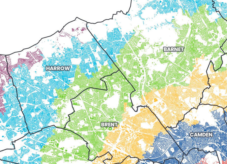
People in London generally know what tube zone they live “in”. There are no defined zones as such, zones are simply classifications assigned to each tube and railway station in, so it is likely people label their “zone” based on the zone of their nearest tube/railway station. Your zone, or the number of zones you travel in, set your journey fare.
Zones make a big difference to how much it costs to travel around London on the tube and railway network – particularly when travelling into or out of Zone 1 in the centre. As such, there are fairly regularly campaigns to get certain stations reclassified by Transport for London, who defined and control the zone system. Such a change though sometimes creates more problems than it solves – as TfL changed Stratford to Zone 2/3 from Zone 3, after the London 2012 Olympics gave this east London hub more prominence. Changing to Zone 2 would have made it cheaper to get from Stratford to central, but more expense for people travelling from outer London to Stratford – so the Zone 2/3 is a cartographically ugly compromise on the tube map.
Anyway – despite the lack of zone “areas” as such, the GLA published a dataset assigning each small statistical area in London to a zone, based on the nearest station – and Alasdair Rae has mapped this data onto a base Ordnance Survey dataset showing all building blocks in London, and coloured all the buildings in each zone with a distinct colour. Visually it is rather striking. It shows, if nothing else, that the fares are “fair” – there is no great consipracy, rather just that they are concentric rings, slightly squished because London is wider than it is tall, due to the effect of the ancient settlement running along the Thames and lines of hills to the north and south.
It also shows, much better than a normal borough map, which London boroughs are actually “inner” (Zones 2-3), which are “outer” (Zones 4-6?) and which are a bit of both. For example, Haringey is unambiguously a Zone 3 borough, and Redbridge, despite being on the London border, almost entirely Zone 4 – because the London border is really not far from the centre of town, here. It also shows just how rural much fo Zone 6 is -the majority of Zone 6 Bromley, for example, has no buildings nearby.
There are a couple of alternative versions – his original minimalist one with no borough boundaries , and one with the tube stations on it.
London’s fare zones actually extend out of Greater London these days – but that’s a map for another day.
- View the original map.
Maps © Alasdair Rae.
- Pingback: London’s weekly railway news
Why is an area quite far into the conurbation like Kingston in Zone 6 while areas further out are often in Zone 5 ? Also, why is Epsom, clearly part of the conurbation, not in Zone 6 ?!?
Have to disagree as a Woolwich resident who lives in zone 4, a rivers width away from zone 3 on the direct opposite bank of the river… also are you aware a train journey south of the river cost more than a TFL dlr/tube journey from the same zone, unlike North of the river where all forms of railed transport charge the same for a zone 4 to 1 journey
I’ve made a more accurate version of this. See https://rti2-demo.whoosh.media/demo/demo
Southwest London is being completely robbed by the Zone system. So many places here should be in zone 3 4 or 5. Many are unfairly in Zone 6 regardless of their actual distance from the city center, It’s as if all the rules of this system go out the window when applied to Southwest London!?
- Pingback: British lack-of-flair in naming things « Quotulatiousness
Leave a Reply Cancel reply
Your email address will not be published. Required fields are marked *
London Tube Map 2024
On our website, you will find the following information about the London Underground : maps of daytime services, fares, timetables, maps of each tube line, maps of the night tube services, and the railway lines connecting each end of Greater London.
The Tube map is also available showing wheelchair-accessible stations and in 15 languages (in PDF format) .
London Tube Night Service Map
- Central Line (Ealing Broadway to Loughton).
- Jubilee Line (Stanmore to Stratford).
- Northern (Edgware/High Barnet to Morden)
- Piccadilly (Cockfosters to Heathrow)
- Victoria Line (Brixton to Walthamstow Central).
- London Overground (New Cross Gate to Highbury & Islington).

- Underground: Tube lines are identified with different solid colours and a single thick line. The London Tube has 11 lines: Bakerloo, Central, Circle, District, Hammersmith, Jubilee, Metropolitan, Northern, Piccadilly, Victoria, and Waterloo.
- Trains: represented by two parallel lines (=). We will find three railway lines on the map: DLR (Docklands Light Railway), London Overground, and Elizabeth Line.
- Interchange stations: Stations where you can change from one tube line to the other. They are represented by a white circle and a black outline.
- Zones: London's transport network is divided into 9 zones. Zone 1 covers the city centre, and zone 6 starts in the outskirts. #Tip for tourists: In zones 1 & 2 you will find the most important London attractions.
- Fares: Standard single-journey ticket prices range from £6.70 to £9.80, varying by zone. Using a Prepaid or contactless cards offers significant savings. With an Oyster Card or Visitor Oyster Card, fares range from £2.70 to £3.60 during off-peak hours and £2.80 to £5.60 during peak hours.
- General Operating Hours: Typically, from Monday to Saturday, services run from 5:00 am to 12:00 am, and on Sunday from 7:00 am to 11:00 pm. Peak times are on weekdays, between 6:30 am to 9:30 am, and 4:00 pm to 7:00 pm, excluding public holidays. Please note that these times are approximate and can vary depending on the station and day. For precise station-specific timings, refer to our detailed schedule .
Maps of London Tube lines
If you need information about a particular line, you can click on any of the links below and access individual maps of the London Tube and Overground lines.
Where to buy tourist tickets online?
On the Tiqets website , you can buy cheaper tickets for all kinds of museums, shows, monuments, attractions, and tours. On some items, you can save up to 20%. In most places, with these tickets, you will not have to wait in line at the entrance.
Interesting Facts about the London Underground and its map
The London Underground, better known as the Tube, is one of the most extensive networks in the world. In London, the tube is connected and integrated with trains and trams.
There are ticket vending machines where you can buy tickets or top-up prepaid cards.
You must touch your card or ticket at the yellow reader at the beginning, and at the end of your journey.
There are different benefits available for children and elderly people.
The London Tube = Design Icon
The Tube is a symbol of London and it is part of its identity. These three design features are a registered trademark for London and they made it a world icon, simply unique.
- The TUBE MAP designed by Harry Beck.
- The logo, known as the Roundel.
- The Johnston typography, used on posters and maps.
The Tube map was devised by Harry Beck, who created this design in 1931. Its schematic style makes a complex transport network easy to understand (it is schematic because it does not follow the distance scale).
This map design was imitated by all the underground and railway companies in the world. The model is also used in other fields, such as aeronautics. The creator, Mr. Beck, was employed by the railway company. The first time he presented the map, it was rejected.
The Roundel is the underground's logo. Its circular design with a red, white, and blue stripe in the centre dates back to 1900. It was inspired by the posters of the Paris metro.
Finally, the trilogy is completed by the "Johnston" typography , which can be seen on the map and on all the Underground signage, extending its use to the Overground and the railways that are part of the TfL. This typography was especially designed for the tube.
Questions and answers
What are the London Underground zones?
- London Transport is organised into 9 concentric zones.
- Zone 1 is the historic centre. Zone 6 is the beginning of the suburbs.
- #TipForTourists When buying tickets for the London Transport, ticket machines will prompt you to select the zones to visit to give you the lowest price, all attractions are within zones 1 and 2, therefore, you should buy tickets to move between those zones.
Why are there different types of lines on London Underground maps?
- The Underground is divided into 11 lines. Each line has a different colour and it is represented by a "full line".
- Trains and Trams are represented by two parallel lines (=).
What's a railway?
- A train moves over a steel railway track. Locomotives pushed the wagons to travel over ground.
- The London Underground network is integrated with DLR trains, London Overground, and the Elizabeth Line.
What is DLR?
- It stands for Docklands Light Railway. It is a driverless train network. The DLR is similar to the Tube, but it runs above ground rather than on underground tunnels and it is divided into 6 routes.
Is Elizabeth Line a tube?
- It's a nuanced question because the Elizabeth Line, despite including the word "line" in its name, is technically a train service. The Elizabeth Line operates on traditional railway tracks, features larger carriages compared to typical Tube trains, and its doors do not open automatically like those on the Tube.
- The term "line" is often associated with underground services, but in the case of the Elizabeth Line, it refers to a railway service that operates both above and below ground.
How many lines does the London Underground have?
- The London Underground has 11 lines: Bakerloo, Central, Circle, District, Hammersmith, Jubilee, Metropolitan, Northern, Piccadilly, Victoria and Waterloo.
- The rest of the lines, although transport lines, run above ground.
Why is the London Underground called the Tube?
- It's called like that due to the tubular shape of its tunnels.
Which was the first city in the world to have a tube?
- The first city in the world to inaugurate an Underground was London
When did the London Underground open?
- The London Underground, with its first section, the Metropolitan Railway, opened in 1863. This was the world's first underground railway.
How many stations does the London Underground have?
- Nowadays it has 272 stations.
How many passengers use the London Underground every day?
- The latest figures (year 2022), show that 5 million passengers, mainly "commuters", use the Underground every day.
London tube map | Timetable | Fares | All subway lines | Metro Roma | Metro Madrid
Account Options

How to Get Around London: A Guide to the London Public Transport System
T his comprehensive guide to getting around london will help you understand and navigate the london public transport system so that you can spend more time enjoying the city instead of deciphering underground maps.
First of all, if you’ve decided on visiting London, let me congratulate you on your excellent taste. It’s my favorite major city in the world and one of my all-time favorite destinations. While there are a million things to do in this amazing city, I want to be sure you know how to get around London before you go.
Our family spent several months living in London without a car and also several months living outside the city, and we have also been back to visit several times. Using London public transport is one of our favorite things to do in London and I think it’s actually part of the fun of this city and what makes it so special. While the London transport system is as extensive as the human nervous system, it can also be simplified and easy to use.
Since it’s such a huge city, getting around London can consume a good portion of your trip, but I’m going to share some tips that will help you to understand your options and make the most of your time. Sometimes transportation in big cities can be kind of a drag, but in this city, it’s all so iconic, clean and easy that it makes getting around London part of your true experience. Here are some tips to help make getting around London life go smoothly.
Don’t have time to read a bunch of reviews and blog posts? Here are our top picks for visiting London:
Wanderlust london guide.
If you’re traveling to London, you’ll want to have a solid itinerary that will help you organize your time in the best way possible and maximize your time and money. I’ve created this 5-day London itinerary that will help you see the best sites in London along with some hidden gems. It contains open-and-go day-by-day schedules and expert advice from me!
Our favorite Hotels in London
- Marriott County Hall
- Georgian House Hotel (Harry Potter Chambers)
- The Mad Hatter Hotel
- H10 Waterloo
Must Have: London Pass
Our Favorite London Activities
- Hop On Hop Off Bus
- Tower of London
- Harry Potter Studio Tour
How to Get Around London: The London Public Transport Zones
London is conveniently…or maybe just confusingly…divided into 9 different zones that determine your fare on most public transport. The zones are circular with 1 in the center and 9 being the outer circle. Zones 1 and 2 are contained in central London. In the London transportation system, the fare generally gets more expensive the more zones you cross.
How Much Does it Cost to Use London Public Transport?
Getting around London is fairly affordable, especially if you’re traveling with kids , since ages 10 and under ride anything that uses an Oyster Card for free, including the Underground and the Bus. Fares for riding each mode of transportation differ. The London buses cost around £1.5 per ride. A single tube fixed price is £2.40 with an Oyster card, but the card has a daily cap and even weekly cap which you can see in the chart below, which means that if you’re riding London public transport all day long you are saving a ton of money.
Different Types of London Public Transport
- Underground
- National Rail
- Heathrow Express
I know that list seems long and scary, but don’t be worried, it’s great to have options and you don’t need to use all of these! I’m going to break down each option so you’ll know the ones that will work best for you.
1. The London Underground
The most well known, and most used London public transport is the London Underground, also known as “the Tube.” It is the oldest underground transportation network in the world, first opening in 1863, and carries over one billion passengers a year. The system is vast, with over 250 miles of track and over 200 stations.
The London Underground is the best way to get around London if you want to move quickly across a large area. And thanks to its efficiency, trains are usually on time. You can easily find “Tube Stations” all around the city that will allow easy access to its 11 different colored lines. The stations are easily recognizable with the big red circle with “UNDERGROUND” written across it.
Trains generally run at least every 10 minutes between 5 am and midnight, some lines offering 24-hour lines. You can plan your journey on the London Underground here or you can use Google Maps on your phone. To ride the London Underground, you’ll need a ticket or an Oyster Card. Oyster cards are plastic credit card like passes that you can “top up” (add money to) at any time.
They work on the underground, bus systems, and some National Rail. Children 10 and under ride the bus and tube for FREE ! To buy your Oyster card, find a machine in any Tube station or ask an attendant. To ride the Tube, hold your Oyster Card over the indicated area on the barriers on your way in and out. The barriers will automatically deduct your fare from your card.
2. Black Cabs
Of course, you can’t leave London without getting a ride from a London Cabby. The cabbies are required to take a difficult test to get this job. It can take years to study and pass the test and they must know the streets of London like the back of their hand! If you want to know about something you pass, ask the cabby, he most likely knows a bit about everything! London cabs seat 5 in the back.
They can get quite expensive so we try to save them for a rainy day (literally). Some cabs take credit cards, but about 80% of the ones we took were cash only. Fares are metered and paid upon completion of the journey. As a common courtesy, it’s always a good idea to go to the passenger window of the cab before getting in and telling them where you’re going to be sure they are willing to go there, especially if it’s far.
When the Taxi sign is lit, the cab is empty. To hail a cab, stand on the curb and hold your hand up. Also, look for designated Taxi pick up spots and be sure not to stand on a “zebra crossing” because they are not allowed to stop there.
My personal favorite way of getting around London is in the iconic red double-decker buses. With over 2 billion journeys a year taken by bus in London, this is the most popular mode of transportation in the city, and for good reason. Here are a few reasons why I think the bus is the best way to get around London:
- Cheap: There is a set fare per journey, so even if you’re going from one end of the city to the other, your fare is still only 1.50 pounds! Also, kids 10 and under ride free!
- Convenient: There are literally bus stops on almost every corner of London and the buses run continuously throughout the day and night, even stopping where there may not be an Underground station.
- Accessibility: If you’re getting around London in a wheelchair or with kids in strollers, the bus is the most easily accessible mode of transportation, lacking the necessity of stairs. If you have a stroller you can just wheel it right on to the bus.
- Oyster Card: You can pay for the bus using your Oyster Card by simply touching it to the yellow reader. You only need to use it at the beginning of your journey.
- The View: Riding the bus in London provides you with incredible views of the city and allows you to see more of London while in transit than you otherwise would by being underground on the Tube. Yes, it’s slower than the Underground due to being restricted by traffic, but I think the trade-off is worth it.
4. River Bus
Guess what else you can use your Oyster Card on? That’s right, you guessed it: the riverboats of London known as the Thames Clippers River Bus. I feel like this is one of the most underutilized modes of transportation in London. Maybe because it’s a little pricer or because the boats don’t run as frequently as the buses or the Tube, but the riverboats can be a convenient way to get across the city while seeing it from a truly unique perspective.
5. Overground
The London Overground is pretty much the Underground, but, you guessed it, above ground (even though much of the Underground is also above ground). The overground is fairly new and basically covers areas that the Underground does not. You can use your Oyster Card on the Overground and the fare system with zones is the same as the Underground.
6. DLR (Docklands Light Rail)
This fully automated rail system (without any drivers) services mostly the East and South of Central London near the docklands area of London. It works just like the Underground and Overground and you can use your Oyster Card.
7. National Rail
What?! More trains? Yes! Most national rail services consist of several different lines that connect London to the rest of the country. Many commuters use these rail lines to commute from the suburbs surrounding London. Your Oyster Card will not work on National Rail lines and children 10 and under are not free, but usually ride at a discounted rate. There will be machines at the station where you can purchase rail tickets and usually a ticket office where you can talk to a human.
8. TramLink
This small tram system services South London, so if you’re staying there you’ll need to know about this one. The TramLink has a fixed fare and works like the bus so you only need your Oyster Card on the way in, not the way out.
9. Heathrow Express
If you’re coming to London you’re most likely flying into Heathrow Airport, London’s largest international airport. If so, taking the Heathrow Express is the fastest way to get into the city center. Don’t make the newbie mistake of taking a cab all the way into London! Book your tickets ahead of time online here to get the best deal. Fares range from £5-£32 depending on when you book.
10. Ride Share
- UBER : UBER is regularly used and accepted in London. It’s an easy way to book and pay for transportation and you can now split fares with your travel buddies. It’s not quite the same experience as riding in a Black Cab in my opinion, but just as efficient. When we were there we found the price to be about the same, but you don’t have to worry about having cash on you for UBER at least. If you’ve never used UBER, don’t worry it’s fun, safe, and easy. Here’s a coupon for $5 off your first ride.
- Free Now : Despite its name, Free Now is not free, but it will save you a few pence! What I like about Free Now is that you can call a regular car or a black cab, which is much easier than trying to hail one down on the street! I’ve also found it to be a bit cheaper than UBER. Download Free Now for Apple . Download Free Now for Google .
Biking around London can be a really fun and inexpensive way to see the city and get you from place to place on a nice day. The bikes with “Santander” written on them are affectionately known as “Boris Bikes” after Boris Johnson who was the Mayor of London when the bike program launched.
The bikes only cost £2 to access the bikes and the first 30 minutes are free. You could technically bike somewhere for 30 minutes, check in your bike, then check out a new bike and ride it for 30 minutes and so on, potentially paying only £2/day for your bike. There are 750 docking stations and 11,500 bikes to rent around London. You can use a credit card or the app to pay for your bike.
London has also recently put in millions of pounds to creating more bike lanes around the city to help the environment and the flow of traffic. They’ve done a nice job and you’ll see dedicated lanes for bikes all around the city, and especially in the most congested areas.
If you want to know how to get around London on a bike, you can learn more about the London Bike Scheme here .
12. Walking
Walking is a great way to see a lot of London. Most things in central London can be seen by walking and it’s a great way to make more room for all those delicious foods you’ll be eating! Plus, if you’re on a budget it’s the best way to get around London. Be sure to check the distance between you and your destination on Google Maps. You’ll be able to see a different view of London by walking the city. London is full of beautiful parks and they can make great short-cuts and lovely walks.
What is the Best Way to Get Around London?
While there’s no right or wrong answer to this questions, I definitely have my favorite ways of getting around London. As I’ve stated above, the bus is my personal favorite way to travel in London, but the Underground may be the fastest. If you’re lucky, you’ll have the chance to use every mode of transportation during your time there.
Do You Need an Oyster Card to Travel in London?
Having an Oyster Card in London is not strictly required, but I would highly recommend getting one. A London Oyster Card is the cheapest way to get around London, it covers journeys across London’s public transport networks including the Tube lines, buses, overground train station, and DLR, and can be used any time of the day throughout the week.
It makes life easier and will be more affordable. There is actually a price cap currently of £9.80 for zones 1-4. So you know that you won’t be paying more than that each day you are in London, regardless of how many times you ride. This article from London Toolkit about the London Public Transport fares was really helpful.
Go Contactless
Use your contactless card, phone, or watch to pay for the tube map. Now riding the tube and bus is even easier with contactless payment. Just use your card, phone, or watch as you would when making a purchase. Be sure to “swipe” in and out using the same contactless card so you’ll be charged the correct fare.
Tips for Getting Around London
- Buy an Oyster Card or Prepare Contactless Payment in Advance: Having an Oyster Card is a great option as it will allow you to ride multiple forms of transportation around London without having to purchase single-ride tickets.
- Download Google Maps App and use it! Even if you have to look up directions before you leave wifi. I recommend using google maps public transit directions. These have almost never failed me! The app gives you train or bus times and even track numbers, alternate train times, bus stop letters, and exit names. Google Maps will also provide you with several options for public transportation around London. You can see below that to get from the Tower of London to Westminster Abbey using public transportation you have the option to take the Underground or the River Boat.Along with detailed public transport maps and directions, Google Maps will also provide detailed walking directions from the transit stop to the destination.
- Mind the Gap: Those signs everywhere that say “Mind the Gap”…they’re no joke! During my last trip to London, my nephew got stuck in the gap. It was pretty scary, so just be careful.
- Stand on the Right: When riding on the escalators, stand on the right or walk on the left.
- Travel During Off Peak : Try to avoid using public transportation between 7-9 am and 5-7 pm when trains and buses are crowded.
- Try New Things: Don’t be afraid to try different types of transportation like riverboats.
More London Resources
If you need more help planning your trip to London, check out these great resources!
7 Day London Itinerary
London With Kids
Paddington’s Guide to London
Christmas in London
FAQ on How to Get Around London
There are several ways to get around London on a budget. The best way to save money is by taking public transportation such as the Tube, buses and overground trains. You can also rent a bike or walking is always free. Getting an Oyster card and using contactless payment are great ways to pay for your journeys. Additionally, look out for special offers and discounts when travelling.
The current price is £7 and £9.80 for zones 1-4. You can always top up your Oyster card with cash whenever you need.
It costs £20 for the Visitor Oyster card. This allows you to save £1.75 for a single journey with £5.25 as a daily cap. That’s why many tourists and even locals opt for the Visitor Oyster card when travelling around London.
Yes, as the underground stop is usually within walking distance from most places, it makes traveling around London easy. Trains always arrive in 10 minutes and the system is well connected. Additionally, there are Uber rides that are perfect for sharing in groups and other taxi services.
I hope this guide to getting around London has been helpful. You are going to love this city, and now that you know how to navigate it you’ll feel more comfortable and be able to enjoy seeing the sites without stressing about how to get between them. If you have any questions about how to get around London, please ask! You can message me on Facebook or Instagram . -Vanessa
The post How to Get Around London: A Guide to the London Public Transport System appeared first on Wanderlust Crew .
![This comprehensive guide to getting around London will help you understand and navigate the London Public Transport System so that you can spend more time enjoying the city instead of deciphering Underground maps! How to Get Around London: A Guide to the London Public Transport System First of all, if you’ve decided on visiting London, [...]](https://img-s-msn-com.akamaized.net/tenant/amp/entityid/AA1cfSdp.img?w=768&h=515&m=6 "This comprehensive guide to getting around London will help you understand and navigate the London Public Transport System so that you can spend more time enjoying the city instead of deciphering Underground maps! How to Get Around London: A Guide to the London Public Transport System First of all, if you’ve decided on visiting London, [...]")
Your guide to getting around London like a true Londoner
Brenda wong.
This post is part of our ultimate guide to moving to London as a graduate . It’s one thing to have your London crib all sussed out. It’s another to settle in and become a true Londoner. This is our guide to getting around London like you’ve lived here forever.
I remember my first trip to London vividly. A friend and I, both newcomers to the UK, were on our way to a pal’s spare room in Turnham Green. Armed with paper Tube maps (we’d both run out of mobile data), we then got resoundingly lost on the London Underground. Damn millennials who can’t read maps. When we finally escaped the turgid air of our Piccadilly line train, I remember thinking one thing. “Surely there must be an easier way to get around.”
Since that fateful trip in 2011, much has changed. For one thing, we’ve got helpful apps like Uber and Citymapper to help us get around – arguably the two biggest game-changers for the city of London. The Night Tube has launched. Crossrail is coming. Things will continue to change, we reckon. However, there are some hacks that’ll assist you in getting around no matter how the Tube map changes. Let’s start with the basics.
London Zones
We touched on this a little in our guide to picking a place to live in London . In a nutshell, the great Big Smoke is divided into areas called ‘zones’ when it comes to transport.
If you take a look at the map above, you’ll notice that the zones of London progress from inside out. So, Zone 1 is basically Central London, and the further out you get from Zone 1, the higher the zone number will be.
Zones are important if you’re thinking of taking the Tube, the Docklands Light Railway, the London Overground and National Rail services. The reason why the ‘zones’ system exists is because they’re Transport for London’s way of calculating a customer’s travel distance.
Here’s an example. If you live in Zone 3 (let’s say Dollis Hill) and have to travel to Zone 1 (let’s say Old Street), you pay a single fare of ВЈ2.80 during off-peak* hours. However, Willesden Green, just one stop away from Dollis Hill, will incur a charge of ВЈ2.40 to the same destination. Why? Because Willesden Green is in Zone 2.
* A note about off-peak and peak hours
Transport for London (TfL), like some other national transport providers, charge higher fares at busy times in the day. Peak fares in London are charged from Monday to Friday (excluding public holidays), from 06:30 to 09:30 and 16:00 to 19:00.
Public transport
Yo, guys. There are so many ways to get around London-town. Here, we’re going to cover the most likely ways you’ll be getting around. This means, however, that we’re probably going to exclude the following:
The Emirates Air Line, Trams, River and Taxis & minicabs. Why? The first three only cover small, specific areas of London and aren’t as commonly used. As for minicabs, we’ll discuss other, more economical alternatives later, as these can be super-expensive.
Getting around London by the Tube and by rail
Ah, the iconic London Tube. Everyone’s got their opinion about it, but love it or hate it, getting around on the Underground is, for most commuters, an absolute necessity.
Look, we’re not going to break each Tube line down for you. Everyone’s level of London Underground usage is very different. However, here are our top tips on how to ride the Tube like a pro.
- Plan ahead. On the Docklands Light Railway and London Overground, there’s usually phone signal, but Underground you get nada. Some lucky people get WiFi depending on their phone networks, but only some. For your sanity, plot your route in advance.
- Understand your direction. Your route will be determined by the Line’s terminal destinations, and cardinal directions (northbound/southbound etc.) For example, in order to get from Colindale on the Northern Line to Elephant and Castle, you’ll take a “ Southbound train terminating at Morden .”
- Remember your line changes. Often, getting from one place to another means you’ll change from one Tube line to another. Don’t be alarmed, just make sure you remember which stop to get off at to switch lines. There’ll be signage pointing to the other line, so keep an eye out.
- Walk on the left, stand on the right. This is the absolute golden rule for London escalators. Breaking this rule will expose you as a newbie and slow everybody down. Don’t be that guy.
Getting around London by bus
Controversial opinion: London buses are underrated . For one thing, they don’t use the fare zones system, so each journey you take, no matter where you’re going and how far you’re travelling, will be a flat ВЈ1.50.
Also, London Mayor Sadiq Khan introduced the ‘ Hopper fare ‘ a while back making bus travel even cheaper. Make two bus journeys in a row, and you can get the second one for free. Pretty sweet, and great if you’re trying to budget on that tight graduate salary . Just bear these tips in mind:
- Just like the Tube, London buses are all cash-less. Don’t leave the house without your Oyster card or a contactless credit card.
- Unlike the Tube, sussing out your bus route isn’t as simple. You’d be wise to plan ahead using the TfL website to understand bus routes and your nearest bus stop.
- Many bus stops have multiple locations where buses stop, serving different routes. Make sure you’ve identified the right bus stop, by taking a look at the letter of the stop.
- Most bus stops have destination finders and maps. These can also be helpful for planning your journey.
- Some stops are request stops. Buses won’t stop at these unless someone wants to get off or if you flag them down. Take a look at the stop to see if it says ‘request stop’ on it – otherwise you’ll be wondering why no bus will stop for you.
- If you can’t see the ‘next stop’ display, listen out for it. Most buses will announce each of their next stops as they progress along the route. Make sure you get off at the right stop.
The Oyster Card and other payment methods

Look at this card. The double-blue, the smoothness of the white curve. This card, my friends, is the Oyster card. It’s literally your ticket to the city.
- Bus and rail travel in London is nearly 100% cash-less. You can top up your Oyster with cash credit and use it as a pay-as-you-go card.
- To use your Oyster card, there’ll be a yellow card reader you can tap to gain entry to a bus or to the Underground. (On trains, you need to tap in at the beginning of your journey, and tap out. On buses you don’t need to tap out, just tap in.)
- If you want, you can also load up your Oyster card with a weekly, monthly, or yearly Travelcard . This means you won’t need to top up as often, which is really convenient.
- The only other alternative to the Oyster card (bar paper season tickets), are contactless debit or credit cards . TfL introduced this system a couple of years ago, so, if you have a contactless card you can use that instead of the Oyster. The future, eh?
- You can buy Oyster cards from most Underground train stations. They cost (a refundable) ВЈ5, and then you top it up with whatever money you need.
Tickets and pricing
Guys… this is where it gets a little complicated. Remember our little talk about Zones earlier? That’s just the beginning of the various ways tickets and prices are calculated on London transport.
We’re not going to dive too deep into how much it costs to get from one zone to another. Instead, here’s a few things to keep in mind.
- Check your Oyster card balance before you travel. You can do this online, or at any Oyster top-up machine.
- Keep capping in mind. Capping is a feature of pay-as-you-go. It allows you to travel as much as you like either in a single day, or in a week (Monday to Sunday). It limits the amount you pay for all you travel – so, if for some reason you need to take a crazy number of journeys in a day, don’t stress! The travel cost gets capped.
- Weigh up the cost of a Travelcard. Occasionally, just getting a season ticket will be more cost effective and convenient that using pay-as-you-go. Check your budget and see if you need one. The only issue with this is, if you’ve purchased a Travelcard for certain zones, it’ll only be valid for those zones. Traveling outside of them will incur some extra charges.
- Check if you qualify for a discount. Under 25? Have a 16-25 Railcard? You can actually add your Railcard to your Oyster account online and get 1/3 discount on off-peak fares. Every penny counts, y’know.
Cycling in the city of London
You can hire bicycles in London to get around, which is possibly the best idea ex-London Mayor Boris Johnson championed during his tenure. Santander Cycles docking stations can be found literally all over London, which makes it super easy to get around and get exercise at the same time.
It’s an initial ВЈ2 to get access to a Santander Cycle for 24 hours. The first 30 minutes of each journey is free – after that it costs ВЈ2 per 30 minutes.
Useful apps you won’t be able to live without
We all know about Uber and Google Maps. How we got around without those two apps, I can’t even imagine. However, there are three more apps you should really clear some storage on your iPhone for:

Pals, my love for Citymapper knows no bounds. It is by far the best app for getting around London. It’s journey planner is probably the best part about it – allowing you to mix up bus and Tube journeys easily. It’ll also estimate walking times, and provide you with rain-safe options. Sweet.
We’re mentioning Trainline here because of their fantastic user experience. It’s super easy to book train tickets if you need them (for when the city gets too much and you need an escape.) It’s also great for checking live train departures, if, like me, you commute using National Rail trains rather than a TfL service.
London Black cabs are usually more expensive than grabbing an Uber. However, if you’re pernickety about safety, you might feel more at ease in a licensed London Black cab. As a woman in a big city, I’ve found Gett to be a great Uber alternative. Plus, the fares are completely fixed, which is nice – no nasty fare surprises here.
What is the cheapest way to travel around London?
I asked Twitter about their top getting around hacks, and there was one common thread linking their responses. Their top tip? Walk.
Mine is to do more walking instead of tube – walk Leicester Square to Covent Garden etc see much more of London that way! – Louise Upchurch (@Loulou_Uberkirk) May 30, 2017
def walk, walk, walk! Never bother w tube for x3 z1 stops or less – Gail Emerson (@Gail_Em) May 30, 2017
@TfL do a great tube /walking map so you don’t have to stick to the underground. – Stuart Thomson (@Redpolitics) May 31, 2017
Heck, even TfL got involved.
Hi, if it helps at the map is available here – https://t.co/HMvycP4A8D – Transport for London (@TfL) May 31, 2017
Using apps such as Citymapper or even the TfL map above will help you plan the most effective way to get around. Trust us – if you’re traveling from Covent Garden to Leicester Square, it’s actually way more faff to take the Tube.
And there you have it! Check back next week for the final installment of our ultimate guide to moving to London as a graduate:
Your guide to meeting new people and making friends in London
Check out our available graduate jobs in London.
Say hi to us on Facebook , Twitter and LinkedIn ! We’d love to hear from you.
Gen z insights you won’t delete. Delivered to your inbox.
By completing this form, I agree that Debut may keep me informed of its products, services and offerings.

Psychologists x Debut: Insight into Work Personalities
Apply these 6 secret techniques to improve employment opportunities, where to buy cryptocurrency.

Get started
Take four minutes to set up your profile and have great grad jobs come to you.

How to use the Moscow Metro
- recommendations
- How to use the Moscow…

Moscow metropolitan is one of the oldest in the world with the first stations constructed in 1935. Moscow metro, unlike most other transportation systems, is not only a commuting facility, but also a world-famous underground museum! We asked our guides: even using metro every day they can’t avoid being astonished by unique subterranean palaces! Definitely worth seeing, so if you are staying downtown – make sure you don’t miss this!
USEFUL TIPS AND INFORMATION:
But let’s get straight to business and take a look at the Moscow metro map!
- Moscow metropolitan has a circular-radial layout with one circle line (5, brown) and 13 radial lines. There are many interchange stations where you can change the line.
- Look for red M letter sign to find the closest entrance to metro.
- The cheapest way to use metro – Troika transportation card. You can get one at a cashier desk for 50 rubles (returnable deposit) and use it for as many persons as you want. Each ride will cost you 38 rubles. Note, that Moscow metro is not divided into zones, so you don’t have to pay extra.
- Metro opens at 6 a.m. and closes at 1 a.m. You won’t be able to enter Metro after 1 p.m. but if you stay inside you’ll still be able to reach your destination point and exit.
- Use Yandex.Metro application to calculate your route and time. It works offline! There are download links below.
For your own convenience we advice you on getting the application Yandex.Metro which works offline and builds the shortest routes for your needs:
Download yandex.metro from appstore | download yandex.metro from google play, facts about moscow metro:.
- First part of the red line was opened in 1935 under Stalin’s administration.
- There are 14 lines and 223 stations in Moscow Metro, which amounts to 380 kilometers of railway routes.
- The deepest station is Park Pobedy (blue line) – 73 meters, the most shallow station is Pechatniki (bright green line) – 5 meters.
- The station with the longest platform is Vorobievy Gory (red line) – 282 meters. At the same time it’s the only station located on a bridge across the Moscow river.
- For the conveniience of blind people the stations are announced by a men’s voice when going downtown and by a woman’s voice – when going uptown.
- 44 out of 223 stations are recpgnized as a legacy and have a historical value, e.g Ploshad Revolutsii, Novokuznetskaya, Mayakovskaya etc.
- You can book a Moscow Metro Tour right now with one of our local guides – book a metrotour !
We hope you will enjoy you visit to Moscow!
Author: more.admin, related posts.
How to get to the airports Sheremetyevo, Domodedovo, Vnukovo and Zhukovsky from Moscow? 10.01.2020

- Articles >
The Moscow Metro Museum of Art: 10 Must-See Stations
There are few times one can claim having been on the subway all afternoon and loving it, but the Moscow Metro provides just that opportunity. While many cities boast famous public transport systems—New York’s subway, London’s underground, San Salvador’s chicken buses—few warrant hours of exploration. Moscow is different: Take one ride on the Metro, and you’ll find out that this network of railways can be so much more than point A to B drudgery.
The Metro began operating in 1935 with just thirteen stations, covering less than seven miles, but it has since grown into the world’s third busiest transit system ( Tokyo is first ), spanning about 200 miles and offering over 180 stops along the way. The construction of the Metro began under Joseph Stalin’s command, and being one of the USSR’s most ambitious building projects, the iron-fisted leader instructed designers to create a place full of svet (radiance) and svetloe budushchee (a radiant future), a palace for the people and a tribute to the Mother nation.
Consequently, the Metro is among the most memorable attractions in Moscow. The stations provide a unique collection of public art, comparable to anything the city’s galleries have to offer and providing a sense of the Soviet era, which is absent from the State National History Museum. Even better, touring the Metro delivers palpable, experiential moments, which many of us don’t get standing in front of painting or a case of coins.
Though tours are available , discovering the Moscow Metro on your own provides a much more comprehensive, truer experience, something much less sterile than following a guide. What better place is there to see the “real” Moscow than on mass transit: A few hours will expose you to characters and caricatures you’ll be hard-pressed to find dining near the Bolshoi Theater. You become part of the attraction, hear it in the screech of the train, feel it as hurried commuters brush by: The Metro sucks you beneath the city and churns you into the mix.
With the recommendations of our born-and-bred Muscovite students, my wife Emma and I have just taken a self-guided tour of what some locals consider the top ten stations of the Moscow Metro. What most satisfied me about our Metro tour was the sense of adventure . I loved following our route on the maps of the wagon walls as we circled the city, plotting out the course to the subsequent stops; having the weird sensation of being underground for nearly four hours; and discovering the next cavern of treasures, playing Indiana Jones for the afternoon, piecing together fragments of Russia’s mysterious history. It’s the ultimate interactive museum.
Top Ten Stations (In order of appearance)
Kievskaya station.
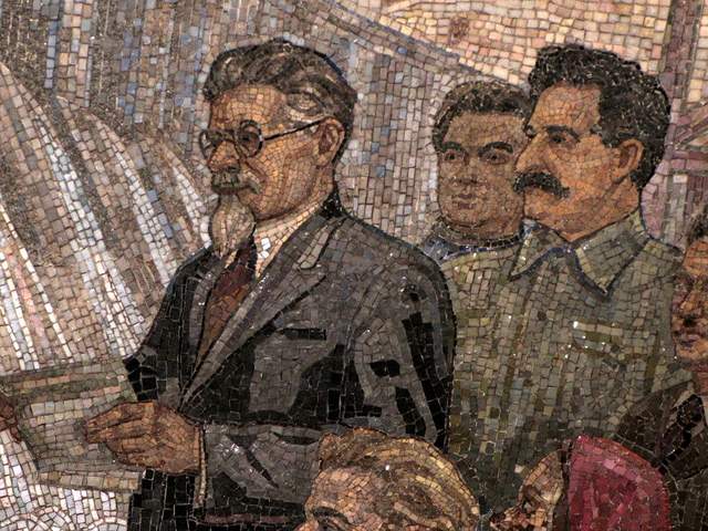
Kievskaya Station went public in March of 1937, the rails between it and Park Kultury Station being the first to cross the Moscow River. Kievskaya is full of mosaics depicting aristocratic scenes of Russian life, with great cameo appearances by Lenin, Trotsky, and Stalin. Each work has a Cyrillic title/explanation etched in the marble beneath it; however, if your Russian is rusty, you can just appreciate seeing familiar revolutionary dates like 1905 ( the Russian Revolution ) and 1917 ( the October Revolution ).
Mayakovskaya Station
Mayakovskaya Station ranks in my top three most notable Metro stations. Mayakovskaya just feels right, done Art Deco but no sense of gaudiness or pretention. The arches are adorned with rounded chrome piping and create feeling of being in a jukebox, but the roof’s expansive mosaics of the sky are the real showstopper. Subjects cleverly range from looking up at a high jumper, workers atop a building, spires of Orthodox cathedrals, to nimble aircraft humming by, a fleet of prop planes spelling out CCCP in the bluest of skies.
Novoslobodskaya Station
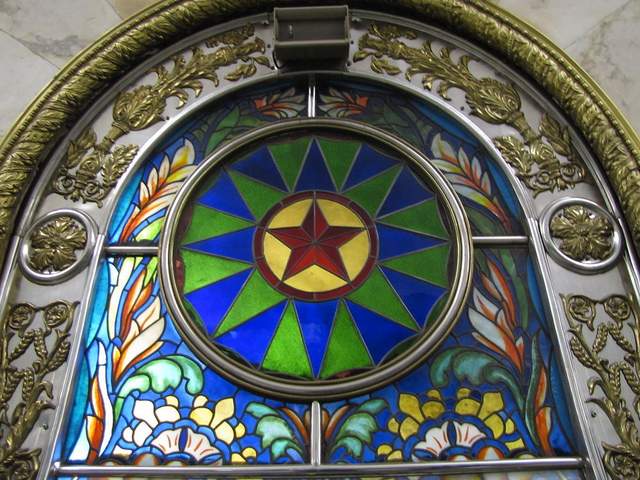
Novoslobodskaya is the Metro’s unique stained glass station. Each column has its own distinctive panels of colorful glass, most of them with a floral theme, some of them capturing the odd sailor, musician, artist, gardener, or stenographer in action. The glass is framed in Art Deco metalwork, and there is the lovely aspect of discovering panels in the less frequented haunches of the hall (on the trackside, between the incoming staircases). Novosblod is, I’ve been told, the favorite amongst out-of-town visitors.
Komsomolskaya Station
Komsomolskaya Station is one of palatial grandeur. It seems both magnificent and obligatory, like the presidential palace of a colonial city. The yellow ceiling has leafy, white concrete garland and a series of golden military mosaics accenting the tile mosaics of glorified Russian life. Switching lines here, the hallway has an Alice-in-Wonderland feel, impossibly long with decorative tile walls, culminating in a very old station left in a remarkable state of disrepair, offering a really tangible glimpse behind the palace walls.
Dostoevskaya Station
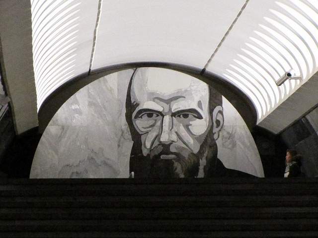
Dostoevskaya is a tribute to the late, great hero of Russian literature . The station at first glance seems bare and unimpressive, a stark marble platform without a whiff of reassembled chips of tile. However, two columns have eerie stone inlay collages of scenes from Dostoevsky’s work, including The Idiot , The Brothers Karamazov , and Crime and Punishment. Then, standing at the center of the platform, the marble creates a kaleidoscope of reflections. At the entrance, there is a large, inlay portrait of the author.
Chkalovskaya Station
Chkalovskaya does space Art Deco style (yet again). Chrome borders all. Passageways with curvy overhangs create the illusion of walking through the belly of a chic, new-age spacecraft. There are two (kos)mosaics, one at each end, with planetary subjects. Transferring here brings you above ground, where some rather elaborate metalwork is on display. By name similarity only, I’d expected Komsolskaya Station to deliver some kosmonaut décor; instead, it was Chkalovskaya that took us up to the space station.
Elektrozavodskaya Station
Elektrozavodskaya is full of marble reliefs of workers, men and women, laboring through the different stages of industry. The superhuman figures are round with muscles, Hollywood fit, and seemingly undeterred by each Herculean task they respectively perform. The station is chocked with brass, from hammer and sickle light fixtures to beautiful, angular framework up the innards of the columns. The station’s art pieces are less clever or extravagant than others, but identifying the different stages of industry is entertaining.
Baumanskaya Statio
Baumanskaya Station is the only stop that wasn’t suggested by the students. Pulling in, the network of statues was just too enticing: Out of half-circle depressions in the platform’s columns, the USSR’s proud and powerful labor force again flaunts its success. Pilots, blacksmiths, politicians, and artists have all congregated, posing amongst more Art Deco framing. At the far end, a massive Soviet flag dons the face of Lenin and banners for ’05, ’17, and ‘45. Standing in front of the flag, you can play with the echoing roof.
Ploshchad Revolutsii Station
Novokuznetskaya Station
Novokuznetskaya Station finishes off this tour, more or less, where it started: beautiful mosaics. This station recalls the skyward-facing pieces from Mayakovskaya (Station #2), only with a little larger pictures in a more cramped, very trafficked area. Due to a line of street lamps in the center of the platform, it has the atmosphere of a bustling market. The more inventive sky scenes include a man on a ladder, women picking fruit, and a tank-dozer being craned in. The station’s also has a handsome black-and-white stone mural.
Here is a map and a brief description of our route:
Start at (1)Kievskaya on the “ring line” (look for the squares at the bottom of the platform signs to help you navigate—the ring line is #5, brown line) and go north to Belorusskaya, make a quick switch to the Dark Green/#2 line, and go south one stop to (2)Mayakovskaya. Backtrack to the ring line—Brown/#5—and continue north, getting off at (3)Novosblodskaya and (4)Komsolskaya. At Komsolskaya Station, transfer to the Red/#1 line, go south for two stops to Chistye Prudy, and get on the Light Green/#10 line going north. Take a look at (5)Dostoevskaya Station on the northern segment of Light Green/#10 line then change directions and head south to (6)Chkalovskaya, which offers a transfer to the Dark Blue/#3 line, going west, away from the city center. Have a look (7)Elektroskaya Station before backtracking into the center of Moscow, stopping off at (8)Baumskaya, getting off the Dark Blue/#3 line at (9)Ploschad Revolyutsii. Change to the Dark Green/#2 line and go south one stop to see (10)Novokuznetskaya Station.
Check out our new Moscow Indie Travel Guide , book a flight to Moscow and read 10 Bars with Views Worth Blowing the Budget For
Jonathon Engels, formerly a patron saint of misadventure, has been stumbling his way across cultural borders since 2005 and is currently volunteering in the mountains outside of Antigua, Guatemala. For more of his work, visit his website and blog .

Photo credits: SergeyRod , all others courtesy of the author and may not be used without permission
IMAGES
VIDEO
COMMENTS
Areas. Greenwich - zone 2. Richmond - zone 4. Wimbledon - zone 3. Last updated: 23 February 2024. Guide to London transport zones and London zone map. Find out about the fare zones you need for underground or train travel passes and tickets in London.
Travel information. Improvements & projects; Safety; Stations, stops & piers; Timetables; ... Night Tube maps; Tube map. PDF 525KB Large print Tube map in colour. PDF 955KB Large print Tube map in black & white. PDF 410KB Step-free Tube guide. PDF 1.07MB Taking cycles on the TfL network. PDF 189KB Tube map showing tunnels. PDF 249KB
TfL Tube and Rail maps, Bus maps, Santander Cycle maps, River maps, Congestion Charge maps, Oyster Ticket Stop map, visitor and tourist maps, audio maps. ... Our live Tube map app helps you plan travel on the move. Visitor and tourist maps. Visitor and tourist maps available to view and download. Audio maps.
Travel information for all London Tube lines: maps, timetables and fares. ... See our maps and guide for Zones 1-2. Walking times between Tube stations. PDF 581KB ... Our live map tool and route finder helps you plan travel on the move. Contact us. Open: Monday to Friday: ...
The London Tube map [PDF 1.2 MB] makes navigating London's Underground rail network simple. This easy-to-use London Tube map shows all nine travel zones, including Zone 1, which covers central London. It also indicates stations with step-free access, riverboat services, trams, airports and more.
Learn more about London's transport zones below. The London Transport Network spans six different zones, covering 55 square miles of inner and outer London. By looking at the network map, you can plan your trip and determine which zones you will need to visit.
Devised in 1933 by Harry Beck, the London Underground map is a 20th-century design classic. It's useful and clearly indicates the general directions taken by the trains (north, south, east or westbound), with all interchanges clearly shown. Download free London travel maps of the London Underground and other public transport routes.
can be used on all tram services. You may be liable for a penalty fare if you cannot show a validated smartcard (or device), a valid ticket or other authority to travel. Online maps are strictly for personal use only. To license the Tube map for commercial use please visit tfl.gov.uk/maplicensing. Maritime Greenwich.
Looking at the London Underground tube map, you can see that zone 1 is the centre of London, with zones 2-9 extending out in a circle around it. ... London Travel Zones Map. The best thing to do is look at London´s Tube Map before you travel to London, to familiarise yourself with it. You can find this here: London TFL Tube Map. You will be ...
Transport for London
Your zone, or the number of zones you travel in, set your journey fare. Zones make a big difference to how much it costs to travel around London on the tube and railway network - particularly when travelling into or out of Zone 1 in the centre. As such, there are fairly regularly campaigns to get certain stations reclassified by Transport for ...
BBC - London - Travel - London Underground Map
London Tube Map 2024. Updated: March 2024. On our website, you will find the following information about the London Underground: maps of daytime services, fares, timetables, maps of each tube line, maps of the night tube services, and the railway lines connecting each end of Greater London.
This map was created by a user. Learn how to create your own. This is a station accurate representation of the Transport for London Zone layout. Zone information taken from https://web.archive.org ...
Story by Wanderlust Crew. • 9mo • 13 min read. This comprehensive guide to getting around London will help you understand and navigate the London Public Transport System so that you can spend ...
The reason why the 'zones' system exists is because they're Transport for London's way of calculating a customer's travel distance. Here's an example. If you live in Zone 3 (let's say Dollis Hill) and have to travel to Zone 1 (let's say Old Street), you pay a single fare of ВЈ2.80 during off-peak* hours.
But let's get straight to business and take a look at the Moscow metro map! Moscow metropolitan has a circular-radial layout with one circle line (5, brown) and 13 radial lines. There are many interchange stations where you can change the line. Look for red M letter sign to find the closest entrance to metro.
Have a look (7)Elektroskaya Station before backtracking into the center of Moscow, stopping off at (8)Baumskaya, getting off the Dark Blue/#3 line at (9)Ploschad Revolyutsii. Change to the Dark Green/#2 line and go south one stop to see (10)Novokuznetskaya Station. Check out our new Moscow Indie Travel Guide, book a flight to Moscow and read 10 ...
Places. Choose postcodes, stations and places for quick journey planning. Plan your journey across the TfL network. Journey planner for Bus, Tube, London Overground, DLR, Elizabeth line, National Rail, Tram, River Bus, IFS Cloud Cable Car, Coach.
Travel information. Improvements & projects; Safety; Stations, stops & piers; Timetables; ... Maps; Tube and Rail; Tube and Rail. Search for stations, stops and piers (e.g. Bank) View map. Open fullscreen map Nearby Near your current location Tube Overground Elizabeth line DLR National Rail Tram About TfL. Help & contacts;
Along with the journey through the Golden Ring of Russia, every travel guide includes a trip to another interesting ring. The ring of Moscow metro stations. We have collected for you the best metro stations of Moscow. Just look for yourself at what amazing art is presented in underground area.
Moscow, Russia. Moscow is the capital and largest city of the Russian Federation. The city stands on the Moskva River in Central Russia, with a population estimated at 13.0 million residents within the city limits, over 18.8 million residents in the urban area, and over 21.5 million residents in the metropolitan area.
Using pay as you go. On Tube, DLR, London Overground, Elizabeth line and National Rail services in London: Peak fares - Monday to Friday (not on public holidays) between 06:30 and 09:30, and between 16:00 and 19:00. Off-peak fares - at all other times and if you travel from a station outside Zone 1 to a station in Zone 1 between 16:00 and 19:00 ...