Galdhøppiggen – the standard route
Join us on an exhilarating day tour to conquer Norway’s highest peak, Galdhøpiggen (2469 m), via the standard route from Juvasshytta. Experience the thrill of crossing a glacier and ascending a rocky and steep section as you make your way to the summit. At the head of Norway, you’ll be rewarded with a magnificent view of the mountain range in Jotunheimen National Park. Embark on this unforgettable adventure and immerse yourself in the natural splendor of Norway’s majestic landscapes.
Norway’s highest peak
Glacier equipment
Season & price 2023
June – September Every day on request
Per person: NOK 450,- No child reduction available
Description
This guided tour to Norway’s highest peak, Galdhøpiggen, follows the standard route from Juvasshytta. This is the easiest way to reach the summit and therefore it can be quite crowdy on sunny days in the high season. However, it is an interesting hike, where you will cross a glacier, and climb over rocky terrain until you reach the summit, from where you can enjoy the mountain panorama. At the summit, you can find a cabin where you can go inside during high season (medio June until medio August) and even buy some drinks and snacks. Our guides are well-experienced and will guide you safely over the glacier and to the summit. The group can contain up to 20 participants. If you like to have a private guide, please contact us. You need to bring good outdoor clothes, sturdy shoes and something to eat and drink.
Below you can find more information about the schedule, equipment, meals, and meeting point.
Can not find what you are looking for? See our frequently asked questions page , or send us an email – we will help you!
When you come by car: Meet us at “ Galdhøpiggen Klatrepark ” at 8.30am: Here you will meet the guide and get the first instruction before we drive to Juvasshytta, from where the tour starts. Be aware that you need to drive your own car all the way to Juvasshytta and that this is a toll road you need to pay for. When you arrive by bus from Lom: Meet us at Juvasshytta. The bus arrives there at 8.40 (2023 schedule).
The guide will give you a harness you need to cross the glacier with and will give you all the practical information for the hike. Then the hike starts. The first stretch is a gradual climb to the glacier. On the glacier, you will be attached to a rope to assure safety. After the glacier section, the steepest part of the hike awaits along a rocky trail all the way up to the summit. Depending on the group you will have plenty of time at the summit to enjoy before we head back. During high season, you can buy some drinks and snacks at the summit cabin. Outside the main season, the cabin is closed and you need to bring enough food and liquids.

Important details
Eat&drink : Please bring enough food with you for the day and water/tea.
Equipment/Glacier equipment : The guide will give you a harness for the glacier crossing you need to carry yourself. The guide will bring a rope and other necessary glacier equipment. When you book child under 10 years, please mention that in the booking since we than need to bring special harnesses with us. Equipment: Bring warm and waterproof outdoor clothes. Weather can change fast and even when you start in sunny and warm conditions, it can get very cold during the day, when the weather change. Bring sturdy shoes with you – sneakers are NOT good enough. We will send you a complete equipment list after booking.
Arrival - Meeting point
Transport to the meeting point is not included.
When you come by car: Meet us at “Galdhøpiggen Klatrepark” at 8.30am: https://goo.gl/maps/vSFyrQkoqCpXAZZVA From there you will drive with your own car the last 15km to Juvasshytta. Be aware that this is a toll road and you need to pay a fee per car with NOK 150,- (2023 price). Arrival by bus: You can take the bus from Lom to Galdhøpiggen – Juvasshytta from medio June until medio August. Departure from Lom: 7:45 am, arrival Juvasshytta: 08.40 am Back from Juvasshytta at: 5:15pm, arrival Lom 6:05pm
Find more day tours
Opplev Jotunheimen med oss!

Day 1: Oslo - Gjendesheim
Bus: Valdresekspressen fra Oslo
Transport from Oslo bus Terminal (Oslo Airport). If you are coming from Oslo Airport, you must count about 1 hour to transfer to Oslo Bus Terminal.
If the time schedule does not fit your flight we can help with accommodation in Oslo, adding one extra night. Let us know.
Accomodation: Gjendesheim turisthytte DNT
Gjendesheim Turisthytte has a history dating back to 1878. The hut is run by DNT and is located in the heart of the Norwegian mountains, with Besseggen Ridge as a neighbor.

Day 2: Knutshøe
First ridge: Knutshøe
Level of difficulty: medium Duration: 4-6 hours Distance: 13 kilometers Ascent: 700 meters
Knutshø is called Bessegens little brother . The mountain has a very cool shape and are exposed with lakes on both sides. The ridge has t w o challenge points where you will have to use all hands and feet.
Gjendesheim Turisthytte has a history dating back to 1878. The hut is run by DNT and is located in the heart of the Norwegian mountains, with Besseggen ridge as a neighbor.

Day 3: Boat cruise to Gjendebu
Boat: Boat cruise to Gjendebu
I dag skal dere ta den flotte båtturen over Gjendevannet . Hvis dere ønsker en kortere båttur, kan dere vandre langs den første delen av innsjøen.
Alt. hike from Gjendesheim to Memurubu
Level of difficulty: Easy Duration: 2-3 hours Distance: 10 kilometers Ascent: 400 meters
This hike is a nice and easy walk alongside the lake.
Accommodation: Gjendebu Turisthytte DNT At 990 masl at the west end of Gjende Lake you will find Gjendebu. The hotel offers a traditional and historic atmosphere, with good local food - and is the oldest cabin of DNT, built in 1871.

Day 4: Bukkelægret
Hike: bukkelægret.
Level of difficulty: Medium Duration: 5 hours Distance: 11 kilometers Ascent: 850 meters
Bukkelægret is an exciting, steep walk with a longer flat section in the middle. The trip takes you through several mountain lakes packed with mountain trout - a perfect area to have lunch. The high route gives a great view over the water Gjende. In the steepest parts of this route you can hold on to the chain for extra safety, or hike an alternative route.
Accomodation: Memurubu DNT Memurubu is a tourist hut at the end or start of the famous Besseggen hiking trail. Memurubu is originally an old mountain pasture dating back to 1872, but has had tourists just as long. Cows are still grazing around the tourist hut, which lies at the mouth of the river Muru in the valley Memurudalen .

Day 5: Besseggen
Hike: Besseggen
Level of difficulty: Medium Duration: 6-8 hours Distance: 14 kilometers Ascent: 1132 meters
Besseggen is one of Norway's most popular hikes. There is a fantastic view of majestic Jotunheimen on a trip over the narrow, airy ridge. With the green Gjende Lake 400 meters straight down on one side, and the deep blue Bessvatnet Lake on the other, you will have an experience you will never forget.
Accommodation: Gjendebu Turisthytte DNT
At 990 masl at the west end of Gjende Lake you will find Gjendebu. The hotel offers a traditional and historic atmosphere, with good local food - and is the oldest cabin of DNT, built in 1871.
Day 6: Gjendesheim - Oslo
Bus: Gjendesheim - Oslo
Transport from Gjendesheim to Oslo bus Terminal (Oslo Airport). If you are going to Oslo Airport, you must count about 1 hour to transfer from Oslo Bus Terminal.
See bus departures from Gjendesheim below Practical information.
Practical information
Below you will find practical information about this trip. Can not find what you are looking for? See our frequently asked questions page , or send us an email – we will help you!
Departures from Oslo
Monday-Wednesday
8.30 am – 1.05 pm
Thursdays
8.30 am – 1.05 pm 3.05 pm – 7.05 pm 5.00 pm – 9.05 pm 5.20 pm – 9.03 pm (Directly from Oslo Airport)
8.30 am - 1.05 pm 1.05 pm – 5.45 pm 5.20 pm – 9.03 pm (Directly from Oslo Airport)
8.30 am - 1.05 pm 10.20 am – 1.35 pm
10.20 am – 1.35 pm 12.20 pm – 4.50 pm 5.20 pm – 9.03 pm (Directly from Oslo Airport)
Luggage transport
We will send your luggage from cabin to cabin, so you only need to bring a daypack.
Departures from Gjendesheim
Monday-Friday
2.00 pm – 6.35 pm
10.00 am – 2.45 pm 2.00 pm – 6.35 pm
10.00 am – 2.45 pm 10.00 am -2.21 pm (Directly to Oslo Airport) 4.00 pm – 8.20 pm 5.35 pm – 10.00 pm
All restaurants offer food based on local ingredients. For breakfast , there will be a buffet. Here you also need to make yourself a packed lunch that you bring to lunch for the day. Use your beewax food wrap . It is possible to fill a thermos, check with the accommodation. Dinner will be served in the afternoon/evening.
Accomodation
Gjendesheim Turisthytte DNT:
Gjendesheim Turisthytte has a history dating back to 1878. The hut is run by DNT and is located in the heart of the Norwegian mountains, with Besseggen Ridge as a neighbor.
Gjendebu Turisthytte DNT:
At 990 masl at the west end of Gjende Lake, you will find Gjendebu. The DNT cabin offers a traditional and historic atmosphere, with good local food – and is the oldest cabin of DNT, built in 1871.
Memurubu Turisthytte:
Memurubu is a tourist hut at the end or start of the famous Besseggen hiking trail. Memurubu is originally an old mountain pasture dating back to 1872, but has had tourists for just as long. Cows are still grazing around the tourist hut, which lies at the mouth of the river Muru in the valley Memurudalen.
Trails and weather
The conditions in the autumn are wonderful, but it can also give some challenges. You need to be prepared to walk in the snow in case of snowfall. We have also described alternative routes for the steepest parts if the exposure or conditions makes it uncountable. In S eptember, normal temperature is between 0-10 degrees.
All the paths are well-marked. The terrain varies from flat and easy to rocky and hilly. All the hikes as a short steep, exposed crux where you will have to use both legs and arms. Thou these sections can be avoided by walking an alternative route around .
Equipment list
W e w ill send you equipment-list when ordering .
- Book Exclusive Guided Oslo Tours
- Tour 1: Exclusive Guided Oslo
- Tour 2: Exclusive Oslo & Tyrifjord
- Tour 3: Exclusive Oslo Fjord Roundtrip
- Fjords of Norway
- Cities of Norway
- Culture of Norway
- Cuisine of Norway
- West coast Norway
- Norway fjords tour
- Sightseeing in Oslo
- Northwest fjord tour
- Hike in Norway
- Western Norway fjords
- Limousine cars
- Driver guides
- Travel Inspiration
- The Galdhöpiggen mountain Hike Experience
Our combined licensed guide and driver can give you the opportunity to visit the wild Jotunheimen National Park. A comfortable 5 hour-drive from Oslo in one of our luxury limousines, cars or mini-buses.

Galdhöpiggen
Galdhöpiggen, Norway’s highest mountain at 2 469m/ 7,100 feet, is situated in Jotunheimen National Park between the lowlands of eastern Norway and the fjords of western Norway. Even though the mountain itself is fairly high, it is relatively easy to climb as it is possible to drive halfway up to Juvass Hytte base camp at 1 840m/ 6,000 feet. However, as there is a glacier along the way, hiring a local mountain guide is required to help you cross it with ropes. This is not as difficult as it sounds – you can walk upright across the glacier, but because the ice tends to move, a guide is required to help you identify and avoid any dangerous cracks.
About 1/3 of the hike consists of rocky and slightly demanding terrain. Healthy legs and appropriate clothing and equipment are therefore essential.

Our guests on this hike were aged 50 to 70 with relatively good hiking experience and excellent equipment (see photos). We therefore did not hesitate to set out on our hike despite the somewhat unstable weather.
Village of Lom

The hotel had an excellent breakfast and we were also provided with a packed lunch consisting of sandwiches and hot chocolate. From the village, Juvasshytta base camp was about a 40-minute drive. The base camp consists of a tourist centre and a motel, where toilets were available and it was also possible to purchase additional equipment.
Our young mountain and glacier guide handed out crampons and harnesses to use when crossing the glacier and explained the rules and security procedures we had to follow during the crossing.
From Juvashytta to the edge of the glacier was an easy 1-hour walk along a mountain path. After a quick break for some chocolate, we put on our crampons and harnessess, and got into a line with our mountain guide at the front, guests in the middle, and our Norway Exclusive guide at the back.
Crossing the Glacier
The walk across the glacier was relatively easy, at a pace appropriate for all members of the group. We had occasional sunshine and did not experience any problems. Nor did we see any cracks in the ice – but as our guide explained, it is the invisible cracks that are especially dangerous, particularly those that form directly beneath fresh layers of snow. As this was early September, there was no fresh snow on the glacier.
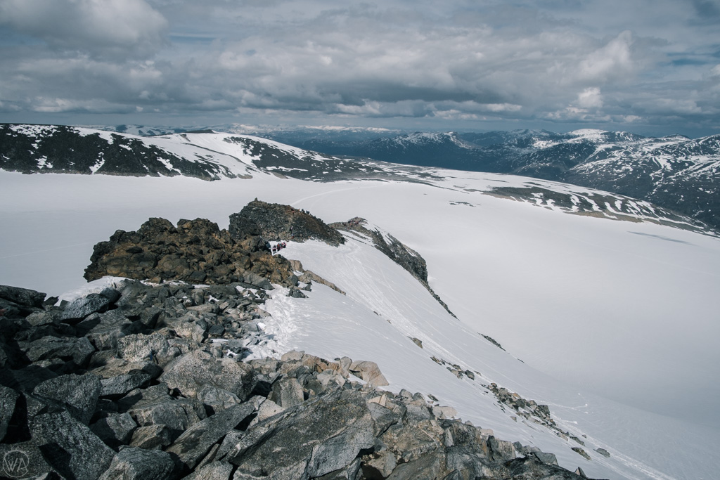
The next hour was slightly more demanding – up the final, rockiest part of the mountain. Though there were no exposed parts, climbing over the rocks was somewhat difficult. However, the view was incredible!
At the top!
There was great excitement amongst our party when we were finally able to spot the cabin at the very top. Towards the very end there were a couple of hundred metres with hard snow where we could walk individually without crampons.

And then we had arrived! The cabin is heated and sells various snacks and drinks. We had our packed lunches at the communal table and got to know some of the other travellers. We then had a photo session at the highest point in Norway. Unfortunately, it was now slightly foggy and we did not have much of the view. But our hike up had been mostly fog-free so we had already seen the landscape.
The relatively easy return to Juvasshytta took about 2 ½ hours. Altogether the entire hike took us about 6 – 7 hours including breaks.
Relaxing at historical Hotel Röisheim

In the evening we had a fantastic (and well-deserved!) gourmet dinner in the hotel restaurant. After a good night’s sleep we returned to Oslo Airport (a 4-hour drive) the next day.
How to get to Galdhöpiggen

Should you wish to go on a Galdhöpiggen hike, p lease send us a non-binding request to get in touch and we will propose an itinerary in collaboration with our partners. If you are a travel agent or incoming operator for Norway tours, we are happy to cooperate to create the best possible travel experience for your guests.
- Day Hikes in Norway
12 Things To Know About Summiting Galdhøpiggen With A Guide
- March 19, 2024

Jotunheimen National Park is home to Norway’s 29 largest peaks, and Galdhøpiggen takes the top spot for being the highest. Whilst getting to the summit requires glacier crossing, it isn’t as inaccessible as one might think. Quite the opposite, during the peak season a few hundred people a day summit Galdhøpiggen.
How to get to the summit of Galdhøpiggen in Norway
When I travel I try not to follow any trends. Sometimes I even consciously skip some very touristy places, like in the case of the famous Trolltunga hike.
It wasn’t the fact that Galdhøpiggen is the highest mountain in Norway that drew me to its summit. It was the exhilarating thought of crossing a glacier to get to Galdhøpiggen’s peak that made the hike so appealing.
To hike the glacier route requires guided assistance and in this post, I will share with you how to book a guide and all other important information to safely summit Galdhøpiggen.
1. Galdhøpiggen summit hike: the stats

- Distance roundtrip : 11.6 km / 7.2 mi
- Time required : 6-8 hours
- Total Ascent : 650 m / 2120 ft
- Type of hike : Out and back
- When to go (2023) : May 26 – 17 September
- Parking : 61.67352, 8.37033
2. About Galdhøpiggen

Galdhøpiggen is not only Norway’s highest peak, but it is also the highest peak in northern Europe. It stands at 2469 meters above sea level (8100 feet).
The peak is located in the Jotunheimen National Park , one of the most visited National Parks in Norway. The park is known for its raw nature, and moon-like landscape created by many years of glaciation. It is also home to another fantastic day hike in Norway – the Besseggen ridge trail.
There are 2 main routes to the summit of Galdhøpiggen:
- From Juvasshytta across the Styggebreen glacier: This is the route I took. It requires the assistance of a guide to safely cross the glacier
- From Spiterstulen cabin to the summit: A much longer approach that takes a whole day and includes over 1500 meters of elevation gain over 13 kilometers. Because this route doesn’t involve glacier crossing, it can be done without a guide.
3. The map of the Galdhøpiggen hike
Above you can see the path I followed from the car park to the summit. I measured the distance, elevation gain, and route with my Garmin Fenix 6S pro watch, which I wore on the day.
4. How difficult is the hike to the Galdhøpiggen summit ?

For the most part, the hike to the summit is surprisingly easy. We had young children, small dogs, and seasoned older hikers in our group. Everyone got to the top safely and with no issues.
There are a few tricky points in the last stage of the hike, where you might have to use your hands for assistance. Icy conditions along the trail even in the middle of summer might also make navigation tricky. Make sure to have appropriate equipment with you.
5. The time window for hiking to Galdhøpiggen in the summer of 2023

During the summer season of 2023, guided tours are available daily at 10 AM from May 26 until September 17. Between July 8 and August 5, there is an additional time slot for 11:30 AM.
Snowy and icy conditions can be expected at any time during the hiking season. I hiked the trail in the middle of July and it snowed the night before. We had some fresh powder snow at the summit.
6. How to get to the Galdhøpiggen trailhead

Juvashytta, the high alpine mountain hut, where the start of the guided hike to Galdhøpiggen begins lies circa 15 kilometers / 25 minutes drive off route no. 55 which is known as the Sognefjellet scenic route – one of Norway’s popular National Scenic Drives.
The drive up to Juvasshytta is quite steep at times. Make sure your car has good brakes and enough power to make it up and down safely.
This is a toll road with an automatic toll station that records your vehicle’s license plate number. You can pay the toll once you get to the Juvasshytta. There are ticket machines near the parking lot.
It is also possible to pay for the toll online within 48 hours of using the road on Paypass.no . The fee for a camper is 200 NOK and 150 for a regular car.
7. How to book a guide for the Galdhøpiggen hike?

Guided tours are operated through the Juvasshytta cabin. Bookings can be done directly on their website (currently under construction).
The cost of a guided tour is 380 NOK for an adult and 330 NOK for a child . Kids must be at least 7 years old to join the tour.
The price includes a harness and carabiner rental , which you will be using for glacier crossing. Since I travel with my own harness I brought it with me on the tour. The guides were ok with it.
8. Facilities along the Galdhøpiggen trail

Juvasshytta offers overnight stays as well as an onsite restaurant and a small outdoor shop. You can also rent hiking boots there in case you forgot to pack your own.
If you are not a guest, you can take advantage of toilet and shower facilities , which can be found in a separate building near the parking lot. Both can be used for a small fee (20 and 30 NOK respectively). The facilities are in top condition and look like have been renovated recently.
Taking a warm shower after a hike was exactly what I needed, especially since I travel in a campervan without a shower.
There is also a small hut (Volehytta) right near the summit, where hot drinks and snacks are sold. It provides great shelter during bad weather conditions, but given the number of people at the summit at any given time, there isn’t enough space for everyone.
Unfortunately, there are no other toilet facilities along the trail to Galdhøpiggen, apart from the Juvashytta, and many hikers choose to pee right near Volehytta, which I found quite disgusting.
9. Galdhøpiggen trail description

We met with our guides 15 minutes before the takeoff. After a short briefing on what the hike involves, we found ourselves on our way.
Guides also divided harnesses and carabiners amongst the group. Each person carries their own harness and carabiner which is used to later attach to a rope.
The hike to the summit of Galdhøpiggen divides nicely into 3 even stages.
Stage 1: From Juvasshytta to the edge of the Stygebreen glacier
The first half of the hike (circa 2.8 km) goes gently uphill across rocky terrain to the edge of a glacier. Since we walked in a quite large group (approximately 100 people) the pace is adjusted to the slowest members. This part took circa 1 hour to complete.
Stage 2: Stygebreen glacier crossing
Once at the edge of the Stygebreen glacier, we were told to put our harnesses on and to clip onto the rope. We were divided into 3 groups.
Once the guides checked if we are all safely attached we started hiking across the glacier. This was the easiest part of the hike, however, we all had to keep a proper distance from one another to make sure that the rope isn’t dragging between our feet.
This is done to ensure that no one falls into a crevasse. Most of the time glacier stay covered by a layer of snow and crevasses aren’t visible to the eye. It took us around 45 minutes to cross it.
Stage 3: Summit push
Once on the other side, we unroped and were told by the guide, that we can continue to the summit on our own. We were told to meet them back in the same spot 2 hours later.
The summit push is the hardest part of the Galdhøpiggen hike and it has a few scrambling sections, where you will have to use your hands for assistance.
10. What to bring and wear on the Galdhøpiggen hike

Despite the fact that it was the middle of the summer season when I hiked to the top of Galdhøpiggen, we still had winter(ish) conditions hence you should be properly equipped. Below is a checklist of things to bring:
- Sunscreen – Both I and my friends forgot to put sunscreen on before we left which resulted in sunburn.
- UV Sunglasses – even on a cloudy day, the sunlight bouncing off the glacier can be blinding
- Warm synthetic or down jacket – to keep you warm at the summit
- Shell jacket – It should always be in your backpack in case it rains or snows
- Gaiters – they can come in handy after a snowfall. They will stop the snow from getting into your boots.
- Daypack – find your perfect backpack in the Osprey Amazon Store
- Hiking boots – preferably above-ankle hiking boots. I own a pair of Hanwag Alverstone boots and highly recommend them.
- Hiking trousers – I recommend the rugged trousers from the Swedish brand called Revolution Race.
- Foldable trekking poles
- warm hut or a buff – a buff has many great uses from headbands to a hat and neck warmer. I own at least 3 pairs.
- wind gloves
- Drinks and plenty of snacks
- Cash to pay for drinks and snacks at the top.
11. Where to stay nearby
If you plan on traveling along the Sognefjellet Scenic route and summiting Galdhøpiggen along the way then I can recommend staying in the Røisheim Hotel and Skysstasjon . It’s a historic hotel with an incredibly cozy feeling. Juvasshytta is only 30 minutes away.
If you want to be very close you can also book a night directly at Juvasshytta.
Another great place to stay nearby is the Nørde-Repp hotel in the Bovervalley also along the Sognefjellet route. It’s located in a very quiet setting, has access to a garden, and is often visited by Elks.
If you would like to be closer to civilization then stay in the Fossheim Hotel in Lom . It will be a great place to continue your road trip toward the Geiranger Fjord.
12. Frequently asked questions about the Galdhøpiggen summit hike

Are you still on the fence when it comes down to summiting Norway’s highest peak? Below are some most asked questions regarding the excursion
Do I need a guide to summit Galdhøpiggen?
A guide is only required on the route which crosses the Stygebreen Glacier. This is to ensure the safety of all hikers. A good knowledge of crevasse crossing is necessary and let’s face it an average hiker doesn’t have that.
Is the Galdhøpiggen hike worth it?
Galdhøpiggen is one of the best day hikes in Norway . Is it my favorite? – No. Do I regret hiking it? The answer is also a no. Would I do it again? Probably not. Once was enough.
Truth be told if you don’t mind hiking in groups you will have a great time. Crossing a glacier and standing on top of the highest peak in Scandinavia is an added bonus!
Other hikes, places, and activities to experience nearby

Sognefjellet Scenic Route
The Sognefjellet scenic route runs between Gaupne in the South and Lom Municipality in the North. For over 100 kilometers the road follows exquisite landscapes and crosses Northern Europe’s highest mountain pass. With plenty of viewpoints to stop and take photos, the road features on some of my Norway road trip itineraries.
Besseggen ridge trail
Besseggen is a full-day hike that traverses along the ridgeline high above the turquoise lake Gjende. Besseggen trail has some of the best views of the Jotunheimen National Park
Support my website!
Hi Reader! If you found any of my articles about Norway useful please consider using the affiliate links in the article or below (at no extra cost to you) when booking your holiday. Thank you.
- Reserve your hotel with Booking.com
- Book your rental car with Discover Cars
- Find your perfect campervan with Motorhome Republic
- Book your tours with Get Your Guide
- Buy your outdoor gear with Backcountry.com (US readers)

Hi! I am the photographer and creator of www.inafarawayland.com. I come from Poland, but I've been living, travelling and working around the globe since I turned 18. A few years ago, during one of my trips to Scotland, I bought my first DSLR and my adventure with photography began. When I am not stuck to my computer editing photos, you can find me hiking somewhere in the mountains.
Related Posts

Beyond Trolltunga – The 30 Best Day Hikes And Via Ferratas In The Fjords Of Norway (Rated From Easy To Difficult)
- April 7, 2023

The Comprehensive Guide To Preikestolen Hike In Norway (2023 Edition)

12-Step-Guide To Molden Day Hike, High Above Luster Fjord In Norway
- April 4, 2023
Leave a Reply Cancel Reply
Your email address will not be published. Required fields are marked *
Name *
Email *
Add Comment *
Save my name, email, and website in this browser for the next time I comment.
Post Comment

The Best Mountain Climbing Clothing Brands to Enhance Your Outdoor Adventures
Glittertind
Oct 08 2023
Galdhøpiggen
- By Mountain Field Guide in Continents , Europe , Fast Facts , Flora and Fauna , Major Mountain Ranges , Mountain Field Guide , Scandinavian Mountains , Trails

Galdhøpiggen, Norway’s highest peak and a remarkable feature of the Scandinavian Mountains, stands with an elevation of 2,469 meters above sea level. Nestled within a landscape of rugged grandeur, this mountain is a highly sought-after destination for adventure seekers and nature enthusiasts alike. The peak of Galdhøpiggen provides breathtaking views stretching across the glaciers, valleys, and the surrounding Scandinavian Mountains, truly encapsulating the raw beauty of Norway.
Positioned amidst the Jotunheimen National Park in Lom, Galdhøpiggen emerges as an iconic symbol of the natural wonders of Norway. This impressive mountain is not just a geographical marvel but also a significant site for scientific research. Its altitude and geographical location make it an excellent observatory for atmospheric studies. In fact, since 1984, the top of Galdhøpiggen has been home to one of Europe’s highest weather stations.
Hiking to the summit of Galdhøpiggen is a popular activity among tourists and locals alike. Despite its towering height, reaching the peak is achievable to most due to well-marked trails and guided tours available during the summer season. However, the weather conditions can be unpredictable and rapidly changing even during summer, requiring climbers to be well-prepared.
The awe-inspiring Galdhøpiggen not only contributes significantly to Norway’s tourism but also reflects the enduring spirit of the Scandinavian Mountains. The mountain’s challenging terrain tests the endurance of climbers while its majestic scale inspires admiration in all who witness it. As such, Galdhøpiggen is more than just a geographical landmark; it is a testament to Norway’s compelling blend of natural beauty and adventure.
Country : Norway
State/Province : Nordland
Mountain Range : Jotunheimen, Scandinavian Mountains
Parents : Scandinavian Mountains
Elevation : 8,100 feet / 2,469 meters
Prominence : 7,992 feet / 2,436 meters
Isolation : 973.9 miles / 1,567.4 kilometers
Nearest Higher Neighbor (NHN): Kriváň
First Ascent : 1850 by Steinar Sulheim, S. Flaatten, and L. Arnesen
Fun Fact : Galdhøpiggen is the highest peak in Norway, Scandinavia, and Northern Europe.
- Flora and Fauna
Galdhøpiggen, the highest peak in Norway and Northern Europe, is not only renowned for its majestic height and breathtaking views but also for its diverse flora and fauna. This impressive mountain, nestled in the Jotunheimen National Park, poses a unique ecosystem that defies the harsh climatic conditions, supporting a variety of plants and animals.
The flora of Galdhøpiggen is predominantly adapted to the cold, alpine climate. The plant life here is characterized by hardy species that can withstand the extreme weather conditions. Cushion plants, such as moss campion and Diapensia lapponica, are commonly found, draping the rocky landscape in a vibrant blanket of colors during the short summer months. Other alpine plants such as Arctic Willow and different species of lichens and mosses also thrive on this mountain, adding to the rich biodiversity of the region.

The fauna at Galdhøpiggen, while not as diverse as the flora due to the harsh conditions, is nevertheless impressive. The mountain hare, Arctic fox, and reindeer are some of the notable animals that have adapted to survive in this challenging environment. Bird species such as the snow bunting and ptarmigan can also be found here. Interestingly, these birds have a unique adaptation mechanism – they change their plumage color from brown in summer to white in winter for camouflage against predators.
Moreover, Galdhøpiggen is home to numerous insects, including unique species of beetles and butterflies, which play a significant role in pollination. The presence of these creatures indicates a healthy ecosystem and contributes significantly to maintaining biodiversity.
Galdhøpiggen is not just a symbol of Norway’s natural majesty but also a sanctuary for various alpine plants and animals. Despite the challenging conditions, the flora and fauna here exhibit an exceptional resilience and adaptability that underlines nature’s remarkable ability to thrive against all odds.

Nestled in the heart of Norway, the majestic Galdhøpiggen is a hiker’s paradise. Standing tall at 2,469 meters above sea level, it reigns as the highest peak not only in Norway but also in Northern Europe. The surrounding area boasts a network of well-maintained trails, offering hikers an opportunity to experience breathtaking panoramic views, serene glacial lakes, and unique alpine flora and fauna.
Among the best trails near Galdhøpiggen is the Spiterstulen to Galdhøpiggen route. This trail starts from the Spiterstulen Mountain Lodge, situated at an elevation of 1,100 meters. The 11-km (round-trip) trail is moderately challenging with a steep ascent but rewards hikers with spectacular views of the surrounding peaks and valleys. It is particularly popular in summer when the mountain is free from snow.

Another highly recommended trail is the Juvasshytta to Galdhøpiggen route. This trail is shorter than the one starting from Spiterstulen, but it involves crossing the Styggebreen glacier. Hence, it requires a guided tour and suitable equipment. However, the extra effort is truly worth it, as this trail showcases some of Norway’s most stunning glacial landscapes.
For those seeking a less strenuous but equally enjoyable experience, the Leirvassbu Mountain Lodge trails offer an array of easier routes, looping around beautiful mountain lakes and through picturesque valleys. The trails vary in length and difficulty, catering to both seasoned hikers and families looking for a pleasant day out in nature.
Whether you’re an experienced mountaineer or a casual nature enthusiast, the trails near Galdhøpiggen in Norway offer an unforgettable hiking experience. These routes provide a unique opportunity to explore Norway’s extraordinary mountain landscape and enjoy its pristine natural beauty at your own pace.

Share this:
- Galdhøpiggen , Jotunheimen , Jutunheimen National Park

Mountain Field Guide
Leave a reply cancel reply.
This site uses Akismet to reduce spam. Learn how your comment data is processed .

The Magnificent Sangre de Cristo: A Guide to the Blood of Christ Mountains

How Old Are the Rocky Mountains?

The Allegheny Mountains: A Comprehensive Guide to Hiking, Wildlife, and History

Haupu Mountain
Like us on facebook.
- Climbing Blog
- North America
- South America
- Switzerland
- United States
- Appalachian Mountains
- Great Dividing Range
- Huangshan Mountains
- Kunlun Mountains
- Rocky Mountains
- Scandinavian Mountains
- Sierra Nevada
- 10 Highest Mountains
- 100 Highest Mountains
Earth’s 10 Highest Mountains

Sister Sites
- Aromatherapy Kitchen
- Cherry’s Kitchen
- Comet Atomic
- Daily Brewer
- For the Birds
- Fun Free Coloring Pages
- Halloween Haunt
- Holly Jolly Christmas
- Home Sparkle
- Life is Better in the Garden
- National Park Field Guide
- Pop and Thistle
- The Tea Room
- Tiki Kulture
- Privacy Policy
© 2024 Mountain Field Guide.
Made with by Graphene Themes .
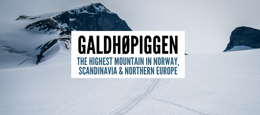
Galdhøpiggen – Climbing The Highest Mountain In Norway, Scandinavia & Northern Europe
Galdhøpiggen, the highest mountain in Norway, Scandinavia, and Northern Europe is on many travelers’ bucket list. Finally, I managed to get there too! In this post, I share with you the details about the Galdhøpiggen hike, crossing the Galdhøpiggen glacier, and the best routes to get to Norway’s highest mountain.
Norway highest mountain – Galdhøpiggen height
Measuring 2469 meters, Galdhøpiggen (from Norwegian: “galdhø-peak”) is not only the highest peak in Norway but also the highest mountain in Scandinavia and the whole of Northern Europe. That makes Galdhopiggen a desirable mountain for many eager hikers. Additionally, it’s not even that difficult to summit if you approach it correctly.
Galdhopiggen location
Galdhøpiggen is located in Jotunheimen National Park (“park of giants” in Norwegian), in Lom municipality in Innlandet county in southern Norway. It’s one of the most popular Norway mountains, and one of the top hikes in Norway , just next to Trolltunga , Kjeragbolten , Romsdalseggen or Preikestolen.

Read more: 30 Best Hikes In Norway You Need To Try
Galdhøpiggen difficulty
Despite the fact that Galdhøpiggen is the highest mountain in Norway, it’s not that difficult to hike to the summit. There are two main routes. One, easier and shorter crossing the glacier, and another one, longer, but not technically difficult, that doesn’t involve glacier crossing. Both are doable for generally physically fit people. More about the Galdhøpiggen hiking trails below.
Hiking Galdhøpiggen trails
Getting to the top of Galdhøpiggen, for it being the highest point in Norway, is not especially hard. There are two main hiking trails to Galdhøpiggen.

#1 Hiking Galdhøpiggen from Juvasshytta and the map
Start and endpoint: Juvasshytta
Total distance: 12km
Total time: 7 hours with a guided tour (including longer breaks), shorter if you’re going alone
Highest point: 2469 m Galdhøpiggen top
Lowest point: 1850 m Juvasshytta
Elevation gain: 619 m
Path: Marked path
Difficulty: Moderate to Challenging
Season: Guided tours are daily from 1st June till September
Cost of a guided tour (as for 2021): 350 NOK per person
Toll road to Juvashytta: 125 nok for passenger car
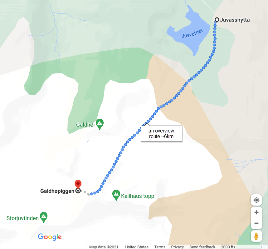
The easiest access to the peak is from Juvasshytta – a cabin in the mountains located at an elevation of 1850 meters. This route involves crossing the Styggebreen glacier, and hence requires a guide if you don’t have experience with glacier walking. This is also the route we took. More about our experience with it later in the post.

#2 Hiking Galdhøpiggen from Spiterstulen
Another option is to hike Galdhøpiggen from Spiterstulen cabin in Visdalen. The popular hiking route from Spiterstulen to Galdhøpiggen is technically not demanding but it’s much longer and steeper, with a vertical elevation difference of 1,300 meters. This route doesn’t cross the glacier so a guide is not needed. There are two other, more difficult routes from Spiterstulen, too. The routes include a few other 2000-meters peaks in one trip as well.
Read more: Romsdalseggen – the most beautiful hike in Norway
Summiting the highest mountain in Norway – my experience
After almost 4 years spent in Norway and countless hikes , I finally decided to scale up the highest mountain in Scandinavia. After sharing the idea with some friends, we gathered a group of 8 and decided to hike together. Since none of us had experience with glacier crossing and some of us didn’t hike much before, we decided to go for a guided tour.
The trip started at 10 am from Juvasshytta, preceded by the safety briefing by the guides, together with the distribution of harnesses for glacier crossing. There was also English translation for non-Norwegian speakers. The weather was great, and we were all eager to start the climb!

Galdhøpiggen hike from Juvasshytta – three stages
Stage 1 – walk to the glacier edge (less than 1 h).
The hike starts with a relatively flat walk through the stones and snow (at the beginning of June) to the edge of the glacier. This first stage is around 2km, and it should take less than an hour. After reaching the glacier, we took a break so the guides could prepare the ropes for everyone.

Stage 2 – glacier crossing (around 45 min)
Glacier on the hike to Galdhoppigen is called Styggebreen, which in Norwegian means “ugly glacier”. The problem with glaciers is that there are often cracks and crevasses opening in them, which in June can still be covered with snow. It can be very dangerous if you fall into one of the cracks. That’s why glacier crossing is done with everyone connected by ropes and guides leading the way.
After everyone clipped to the ropes, we went off to cross the glacier.
The crossing was mainly flat at the beginning, and then it gently rose until we reached a rocky area where we unclipped from the ropes.

Stage 3 – the last leg to the top of the tallest mountain in Norway (around 45 min – 1 h)
The last stage of the Galdhøpiggen hike is the steepest one. This section also involves some scrambling and it is more exposed as you walk on big rocks along the cliff edge.

Read more: Kjeragbolten without crowds
Galdhøpiggen – the highest mountain in Norway
Once you reach the top of Galdhøpiggen, a breathtaking view of the whole Jotunheimen National Park opens in front of you. The sea of 2000-meters-high peaks is below you, and you really feel like you are standing on top of Norway.
On the top, there’s a board with names of peaks around, and also a modern-looking cafe. It truly feels like Norway when on top of the highest mountain in the country, you can buy hot coffee and waffles while paying for it by card or Vipps (local mobile payment app).
The route down follows the same trail.

What to take for Galdhøpiggen hike
Some essentials to take to Galdhøpiggen hike include:
– Sunglasses
– Sunscreen
– Hat (warm hat and sun cap)
– Thin gloves
– At least 2 l of water
– Energy snacks and food for the day
– Hiking shoes
– Hiking clothes – top merino wool baselayer and the bottom merino wool base layer , mid-layer and waterproof jacket and waterproof pants
– Backpack
At the beginning and end of the season (like for example in June) add:
– Gaiters – to prevent snow from falling into your shoes
Harness and crampons (if needed) are provided by the guides.

Where to stay when hiking Galdhøpiggen
The clostest town to Galdhøpiggen hike is Lom. Here, you will find a variety of accommodation, shops, and restaurants. Here are some suggestions:
- Røisheim Hotel & Skysstasjon – top recommendation for accommodation near Galdhøpiggen. This former farm has charming individually designed rooms with private bathrooms in a historic building dating back to 1700. It’s very popular and often fully booked, so book in advance. Check prices and availability here .
- Fossheim Hotel Lom – historic hotel with a traditional and ambient feel. The building dates back to 1897 and offers private rooms with bathrooms. Check prices and availability here.
Both cabins where the hiking routes start from, also offer basic accommodation – Juvasshytta and Spiterstulen.

Galdhøpiggen facts
- The highest mountain in Norway
- Height of 2469 meters
- The highest mountain in Scandinavia
- First ascent 1850
- The highest mountain in Northern Europe
- Accessible to the average hiker
- Located around 5 hours drive from Oslo , 6 hours drive from Bergen

Read more about Norway:
30 Best Hikes In Norway Explained + Map
Tips on how to travel Norway on a budget
Kjerag hike without the crowds – Kjeragbolten
Best Norwegian gifts and souvenirs to bring back from your trip
Trolltunga via ferrata
Would you like to hike Galdhopiggen and conquer the tallest mountain in Norway? Or maybe you already did? Let me know in the comments!
Like it? Pin it!
Sharing is caring!
Related posts:
- Trollveggen Troll Wall Norway – Hike To The Highest Vertical Wall In Europe
- Rjukan Ice Climbing In Norway & Other Things To Do in Rjukan Mountain Town
- Galdhøpiggen – Najwyższczy Szczyt Norwegii, Skandynawii i Północnej Europy
- The Highest Mountain In Jordan – Jabal Umm ad Dami Hiking in Wadi Rum
4 thoughts on “ Galdhøpiggen – Climbing The Highest Mountain In Norway, Scandinavia & Northern Europe ”
Hi I will be in Oslo 21/6/22 – 24/6/22 And want to take a quick trip to hike Galdhøpiggen. I would like to leave Oslo in the afternoon, sleep close by the mountain hike early in the morning and return to Oslo that evening. Can you suggest a guide or tour? Thanks
Hi Sean, you can join a tour from Juvasshytta, here is the info https://juvasshytta.no/galdhopiggen
Hi! Thanks for the detailled article, very useful.
I want to do this hike in september. Is is possibile to do it without a guide ? I mean, is the glacier very dangerous without equipment? I don’t have harnesses or ropes, is it safe to walk on it ?
Thanks for your answer and sorry for my bad english !
Hi, It is recommended with a guide due to possible cracks in the glacier. If you want to go without the guide or equipment, you can take another route that I mention in my post that doesn’t go through the glacier. Good luck! Aga
Leave a Reply Cancel reply
Your email address will not be published. Required fields are marked *
Visit Galdhøpiggen Hiking Trail
Johan Wildhagen - Visitnorway.com
- Map & transport
Galdhøpiggen Hiking
The mountain is probably one of the most popular peaks to hike and climb in Norway.
Highest Nordic mountain
Galdhøpiggen is Northern Europe's highest mountain with its 2,469 meters (8,098 ft.). It is located in one of Norway's most beautiful Jotunheimen National Park.
Special recommended tours
The reason is probably the fact, that it is technically relatively straightforward, without any real mountaineering skills. However, it is strongly recommended to take one of the special offers from local tour operators, where a tour guide offers a great insight into nature and the general area.
The mountain is surrounded on three sides by expansive glaciers except the east. The Styggebrean Glacier is located to the north, Svellnosbrean Glacier to the south, and Storejuvbrean Glacier to the West. The east from Spiterstulen approach is the easiest, because of the minimal contact with a glacier.
Getting there
Find routes to this destination.
Coordinates
- Lattitude: 61.636496
- Longitude: 8.312418
Top Destinations in Fjord Norway

The Hardangerfjord

The Nordfjord

The Lysefjord

The Aurlandsfjord

Geiranger-Trollstigen

Jotunheimen National Park
- Nordic Countries
- Inspiration
- Heritage & Culture
- Nature & Activities
- Design & Shopping
- Nordic Vikings
- Seasons & Weather
- Visitnordic
- Privacy Policy
- Terms of Use
- Become a Partner
Galdhøpiggen Hiking Guide (Multiple Hiking Options + Tips)
Galdhøpiggen is Norway’s highest mountain with the top being 2,469 meters above sea level. Despite being the very tallest mountain in all of Northern Europe, it’s not that difficult to ascent, and most people are able to hike to the top of Galdhøpiggen. So make sure to read the Galdhøpiggen travel guide if you are interested in learning about ascending the peak of the mountain.
The incredible mountain is located in the amazing Jotunheimen National Park , which is filled to the brim with dramatic mountains that look like they belong on a different planet.

Table of Contents
Hiking routes to Galdhøpiggen
There are four different hiking routes to get to Galdhøpiggen, but regular hikers are advised to stick to the first two options . The latter two are OK options if you want a special challenge, but are far more difficult than the first two and require special mountain climbing gear.
So, let’s take a closer look at the different options you got if you want to ascent Galdhøpiggen in Jotunheimen.
Option 1) Juvasshytta over Styggebreen glacier to Galdhøpiggen (Most popular route – requires a guide)
Difficulty : Difficult.
Estimated time : 6 – 8 hours.
Total elevation : 628 meters.
The hike from Juvasshytta to the peak of Galdhøpiggen is by far the most common one, and it’s actually only a 5 kilometer hike . The hike itself begins at the DNT mountain cabin called Juvasshytta at 1,841 meters above sea level.
This starting point can be reached by car or bus, and leaves only around 600 meters of elevation to the top .
Despite only being around 5 kilometers, expect to spend 3 – 4 hours to get to the top, then an additional 2 – 3 hours to get back down . It’s a pretty long hike, but doable by anyone with some decent hiking shoes.
An important thing about this route is that you have to cross a glacier called Styggebreen . This is actually pretty dangerous to do by yourself, so you will need a guide to pass the glacier .
Crossing the Styggebreen glacier
You can book a guide for crossing the Styggebreen glacier at Juvasshytta’s website here . It will cost 380 NOK per adult and 330 NOK per child, and include a 45 minute glacier walk to get over it each way.
The crossing itself is pretty easy. The guide prepares ropes where a long line of people are roped together. This is a safety measurement to prevent anyone from falling in the pits and crevasses in the glacier.
The glacier crossing is considered very safe when done with proper equipment and a guide, but dangerous if you should attempt to cross it alone without glacier crossing experience.
Crossing the glacier without a guide could potentially be fatal. There are examples of fatal accidents from people who have tried to cross the glacier on their own.

The hike is considered to be classified as difficult because it has certain parts where it’s difficult to walk, you need to cross a glacier, and it requires a lot of stamina and proper hiking equipment.
Option 2) Spiterstulen to Galdhøpiggen (Most popular without a guide)
Estimated time : 9 – 12 hours.
Elevation : 1,100 meters.
If you don’t want to cross the glacier, hiking from the Spiterstulen mountain lodge is your best option. This mountain lodge is accessed from the same road as Juvasshytta (just a bit further down), so it’s easy to get to.
The elevation is over 1,100 meters , so you need to be fit to handle it. The distance is around 13 kilometers each way.
The hike itself is actually pretty easy, but it takes a long time for inexperienced hikers . Just keep hiking, and you will get to the top eventually. You should be aware that there are two “fake peaks” where you might think that you make it to the top, only to be greeted by another, hidden peak further up.
The trail has many stony parts with loose rocks , so be very careful about attempting this in rainy weather when the rocks get slippery. Take an extra look at the weather forecast before you leave for the hike.
The nice thing about this route is that you don’t need a guide , so you don’t have to pay anything to get to the top.

The hike is considered to be classified as difficult because it has certain parts where it’s difficult to walk, and it requires a lot of stamina and proper hiking equipment.
Option 3) Geitsætre from the western approach (If you don’t want crowds)
Difficulty : Very difficult.
Estimated time : 12 hours.
Elevation : 1,500 meters.
If you don’t want to be bothered by the crowds that often form on the two main routes to Galdhøpiggen, going from the west can be a good option. This is a much longer hike that will require glacier crossings, so it’s best attempted with a guide.
I only recommend this route for very experienced hikers that know what they’re doing!
Option 4) Ymmelstinden -> Storjuvtinden -> Galdhøpiggen ridge hike (For mountain climbers)
Difficulty : Extremely difficult.
Estimated time : N/A.
If you think that the ascent to Galdhøpiggen itself is too easy, what about climbing Ymmelstinden (2304m) first, then following the ridge to Storjuvtinden (2344m), and finally follow it to Galdhøpiggen?
This is a classic route for mountaineers who want a challenge, but this is not for regular hikers . The route will require tools and skills for small parts of rock climbing, as well as safety ropes for most of the hike.
The hike itself begins from Styggebreen, and instead of heading to Galdhøpiggen after crossing the glacier, head to Ymmelstinden.
Why you should climb Norway’s tallest mountain Galdhøpiggen
Climbing to the peak of the tallest mountain in Northern Europe is really something special, and this achievement in itself is well worth the trip to Jotunheimen to ascent Galdhøpiggen. The entire area is a hiker’s paradise, with some of the most dramatic and incredible nature in all of Norway.
Many consider Galdhøpiggen to be a rite of passage in the hiking community, and you will definitely get some bragging rights by having climbed the highest mountain in Norway.
The entire hike is very beautiful, giving a great view of pristine mountain ecosystems in Norway. It’s really something magic about the place!

The top of the summit
The summit of Galdhøpiggen has an incredible view, and you can see roughly 25 % of all the land mass of Norway in a clear and sunny day!
There’s a small cabin owned by Juvasshytta on top . This cabin sell snacks, coffee, tea, hot dogs, soft drinks, chocolate and souvenirs like t-shirts, coffee mugs, diplomas and a Galdhøpiggen pin. There are tables to sit at inside if you need to get your warmth back.

Galdhøpiggen hiking season
Jotunheimen is known to have a short hiking season due to early snowfall in the fall, and late snowmelting in the spring. This leaves a short hiking season, and the main hiking season to Galdhøpiggen is between June 15 and August 15 .
It’s typically possible to do the hike all the way from June 1 to September 15, but the tails of the seasons are a bit more challenging and unpredictable. If you want to be sure that you can make the hike, book the trip for the main season.
It’s also possible to ascent Galdhøpiggen by cross-country ski in the winter , and the season for this is from October to April.
Preparing for a hike to Galdhøpiggen: What to wear and what to bring
Even though anyone that are decently fit can hike to Galdhøpiggen, you should do some preparations before hiking to minimize your chances of injuries and problems.
There are many travelers who need to be helped down from the mountain by volunteer rescue crews every single year . These tourists are often too tired to keep going, got an injury like a sprained ankle or simply get lost (which is pretty difficult to do in my opinion).
So buy some decent hiking equipment and make sure that you know that you will be able to handle a 6+ hour hike before attempting to ascent Galdhøpiggen.
Normal hiking equipment and clothing are fine, but it’s very important to have good hiking boots . There are several patches of loose rocks that you need to hike on, and these have a high chance of giving you an injury if you got the wrong shoes.
And remember, bring waterproof clothing . You should not do this hike in a t-shirt and jeans!

How to get to Galdhøpiggen
Galdhøpiggen is located in Jotunheimen National Park, and the closest towns are Lom and Otta. It’s easy to get to both of these two towns by either rental car or public transport, so you should not really have any big issues with getting to the starting point of the hike to Galdhøpiggen.
That said, Jotunheimen is not really close to any cities of any importance.. The closest city is Lillehammer, and that’s 2 hours and 20 minutes away by car. So the national park is really in the middle of nowhere.
Total drive time to Lom is:
- 6 hours from Bergen.
- 4 hours and 20 minutes from Oslo.
- 4 hours from Trondheim.
Get to Galdhøpiggen trail start by public transportation
Your first order of business is to get yourself to Otta. The train line between Oslo and Trondheim has a stop there.
From Otta, ride bus line 201 to Lom. This is the town closest to Jotunheimen National Park, and your final chance to buy everything you need for the hike.
In Lom, head on the bus line 202 to Juvasshytta. Either depart at Spiterstulen (for trail option 2), or ride it all the way to Juvasshytta for trial option 1. This bus only operates between June 20 and August 14 in the summer . If you arrive outside of season, you need to ride a taxi to get to the start of the trails.
Get to Galdhøpiggen trail start by rental car
To get to Galdhøpiggen by rental car, drive from wherever you are to Otta. Otta is located just a minute away from E6, one of the biggest roads in Norway, so you can easily get to it from all the major cities in Norway. From Oslo, just drive north on E6 until you are in Otta.
From Otta, drive on Rv15 west until you get to Lom. This is about a one hour drive. From Lom, drive south on Fv55 until you get to a place called Bøverdalen Vandrerhjem (which is a hostel where you can spend the night).
From there you will see signs to take a left towards Juvasshytta. There’s also signs pointing towards Galdhøpiggen, so it’s very easy to find. Now just follow that road until you arrive at Spiterstulen or Juvasshytta.
Tips for when you are hiking to Galdhøpiggen
Below are some tips that you might find useful when you are going on your first hike to Galdhøpiggen.
- Always bring more water and food than you think you need.
- Bring a spare set of clothes for changing in case your clothes get wet.
- Always prepare for the hike to take longer than you imagine.
- Don’t be afraid to turn around if the weather conditions turn bad.

Nicklas is the owner and editor of The Norway Guide, and is responsible for most of the content on the website.
He lives in Skien, Norway with his wife and two children. Nicklas is specialized in Norwegian ecology (including Norway’s geology, wildlife and flora) from his degree in Ecology And Nature Management at University of South-Eastern Norway, but has a particular interest in tourism and content creation.
His biggest hobbies are fishkeeping, going on hikes with his dog, and rooting for the local football team.
Leave a Comment Cancel reply
Save my name, email, and website in this browser for the next time I comment.
Hiking Galdhøpiggen, the tallest mountain in Norway

*The hike from Juvasshytta takes you over the glacier but requires a mountain guide and special hiking and safety equipment.
This article is a part of the Ultimate Guide to hiking in Norway .
Galdhøpiggen is the highest mountain in Norway, in Scandinavia and Northern Europe. It sits 2469 meters or 8100 feet above sea level.
Hiking Galdhøpiggen is not particularly long in distance, but the elevation gain is considerable!
Over a rather short distance, you will climb 3 peaks above 2000 meters / 6562 feet, until you reach the highest of them all.
Albeit the hike is not the most technical hike, and you will meet kids from around 6 years old doing this hike, it does require good physical condition.
The hike up will take you about 4h+ and the descent will be done is 2-3 hours.
Galdhøpiggen is part of the Jotunheimen national park and a treasure-trove of amazing mountains to climb and nature to hike.
How to get to Galdhøpiggen

In essence, you can start hiking Galdhøpiggen from 2 starting points; Spiterstulen, or Juvasshytta.
Spiterstulen is the usual start of the hike, as the Juvasshytta starting point requires a hike over the glacier, which again requires a licensed guide and special equipment.
But if you want to join one of the guides and pay the extra money, the hike from Juvasshytta is both shorter and easier.
It is, however, still quite exhilarating.
In this article, we will address both hikes, and at the end talk briefly about the actual top of the mountain and what you can find there.
Hiking Galdhøpiggen from Spiterstulen
The regular starting point to hike Galdhøpiggen is from Spiterstulen mountain lodge, at 1103 meters / 3619 feet above sea level.
A popular place to stay and a great starting point for many hikes in Jotunheimen.
Actually, you can hike 17 of the tallest mountains in Norway and Northern Europe from here and Spiterstølen actually arrange guided hikes as well – including up and around the glacier.
Here is a great video about Spiterstulen:

Download this cheat sheet to optimize underperforming posts on your website.
Staying at Spiterstulen lodge
As a quick side note about Spiterstulen, in case you want to stay here or learn more about it.
The Spiterstølen lodge has been family-owned and ran for 6 generations. Today, you can actually meet 4 generations working in the lodge.
A great place to stay if you planning to hike Galdhøpiggen or nearby peaks. (People also stay in tents close by the Spiterstølen lodge).
Back to the hike.
This hike is considerably harder and requires an even better fitness level than the one over the glacier (see below).
In Norway, it is considered a “fairly easy hike”, and you will see a lot of families with small children from around 5-6 years hiking up to the peak (yes, really!).
From Spiterstølen to the peak, it is not really a long-distance, if you measure in air distance.
However, in the same amount of kilometers/miles, you will be climbing a pretty steep route of cover 1366 meter / 4482 feet of elevation.
Also, the hike is above 2438 meters / 8000 feet, which means that some may actually start to feel the difference in the air pressure.
The air density ratio at 2438 meters / 8000 feet is 0.86, meaning that the air at that altitude is 86% as dense as air at standard temperature and pressure.
That means effective oxygen % on the top of the peak is around 15%, vs about 21% at sea level (so thinner air, less oxygen).
For most people, this will not be a problem, but few people may notice some slight discomfort or light headaches.
You will be hiking over 2 peaks until you actually are going up the final one to the actual top.
My first hike to Galdhøpiggen

I remember my first hike to Galdhøpiggen so well.
I had not done much research in advance on the hike itself, so I did not know much besides that it is up and up… However, I was super fit and used to heavy physical challenges.
During the hike, it felt like I had been hiking forever and the mountain seemed never-ending.
And then – a peak.
After hours, I could finally see the top.
How disappointed was I, when getting close to the top, I realize that there is another peak behind this one.
Svellnose at 2272 meters / 7454 feet is the first peak you will reach.
But you are not done yet!
You need to keep on, forwards and upwards.
The next peak is Keilhaus.
And finally, after Keilhaus you can actually see the end! The final peak – the tallest mountain in Scandinavia and Norway.
It is a great hike for sure, just don’t do the same mistake as I did, and believe that it is only one peak.
Good gear to have hiking Galdhøpiggen
Also, on my first hike to Galdhøpiggen, I was quite a novice and was missing some gear.
Many parts closer to the top, including the top, is snow-covered.
It was July when I did my first hike, and the snow got quite slushy and wet.
We were far from the first up, and the weather was amazing with blue skies and sun.
I wish I have had gaiters that I could have used and avoided getting the lower parts of my pants and my socks wet from the snow.
Guess what I bought as soon as I got down from the mountain?
Never going hiking where there is now without gaiters in my backpack, that’s for sure!
I would, by the way, strongly advise using hiking boots – high ones!
No running shoes or any other sports shoes!
This is one of those hikes where you really want to have great footwear!

Once I got to the top of Galdhøpiggen, the view is amazing.
You are literally on the top of Norway and can see so far and so many peaks and amazing nature all around.
The weather can be unstable on the top.
For 15 minutes or so and the weather was sunny with great views, only to be replaced with cold humid clouds.
I would say fog if I did not know any better.
But you are in fact “up the clouds” when you are at the peak of Galdhøpiggen.
At the end of the article, you can read more about what actually is on top of the peak – a cabin and a café where you can actually buy coffee and waffles and more!
It is true, and it is crazy amazing!
Hiking Galdhøpiggen from Juvasshytta
A word of warning: This hike requires you to joining a tour/have a glacier guide and equipment for this.
You have to pre-book!
The hike to Galdhøpiggen from Juvasshytta is easier, a bit shorter, and with less elevation gain.
It will typically take you around 5-6 hours of hiking, return. Versus upwards of 8-9 hours return for the regular hike from Spiterstulen.
From Juvasshytta you will start hiking at 1840 m / 6037 feet above sea level, so the elevation gain is only 629 meters / 2064 feet, versus 1366 meters / 4482 feet from Spiterstulen.
Daily tours start around 10:00 and 11:30 during the season and cost NOK 300 per person (NOK 250 for children. NB! Min 7 years).
You can also hire a private guide, which will cost you NOK 6000. Prices are for 2020 and may vary/change for 2021.
You can book your tour or get more information from VisitNorway.
However, the view is amazing and the landscape mesmerising.
The hike over the glacier

Once you have gotten organized with your hiking group and guide, you put on your harnesses, get your instructions, and start hiking up the mountain.
Children (from 7 years old) will get full-body harnesses.
If needed, everyone will also be given crampons.
The first leg of the hike goes along the glacier and basically hike at your own pace, but as a group.
It is a gradual climb of almost 3 km / 2.8 mi.
The hike itself is all in all about 5 km / 3.1 mi.
You are expected to manage this hike in about 1-hour time.
If you are not in the best of shape and spend 1,5 hours or more to get this point, you may be asked by the guide to return back, for your own safety, and out of consideration of the group.
You should not take any (big) breaks before the first common break and the edge of the glacier.
Adjust your clothing as you walk and stay hydrated!
Drink regularly!
Once everyone has regrouped and had a small break, further instructions are given about crossing the glacier.
Once instructions are given about glacier crossings and safety instructions, everyone will be roped together in a long line.
Please line up together with your friends/family.
Please be considerate about families with children, so they get to hike together, and children feel safer.
It is very important to consider your clothing before embarking on the hike over the glacier, as there will not be any opportunities to stop and adjust clothing once on the glacier.
Everyone walks in a line, all roped together for safety.
The rope must be tight.
The crossing of the glacier takes about 50 minutes and once on the other side, there will be a short break and the rope teams are disassembled.
You will now have another 30-60 minutes of hiking up the steepest and last part of the hike up to Galdhøpiggen.
And before you know it, you are on the top of Norway!
Instructions and information about the hike back down will be given by the guides. Follow these guidelines.
This hike is the “easy” hike to get to Galdhøpiggen and albeit it is not really technically difficult, it does require you to have a fairly good fitness level.
As you read above, if you do not manage to keep up the phase, you may be asked to discontinue the hike for your own safety.
At the top of Norway – Galdhøpiggen

Congratulations, you have made it!
Take a well-deserved rest and enjoy the view.
Get the picture proof of yourself on the actual top of the mountain, the highest “bump” on top of the peak (just look for the line, everyone wants a picture from the peak of the peak).
One of the amazing surprised on top of Galdhøpiggen, is the café!
Can you imagine?
A café at 2469 meters above sea level?
You can, without a shadow of a doubt – and fact in hand – say that this is the café with the best view in Scandinavia!
Here is your chance to take a part in the Norwegian cultural highlight!
Get yourself an overpriced waffle with brown cheese, a cup of pissing thin coffee, a bar of Kvikklunsj chocolate at triple prices, and take in the atmosphere!
Enjoy the chaos and be mesmerised about the view on top of Norway!
It does not get better than this!
Oh, and if the weather is nice, you can see Glittertind in the distance. The Glittertind peak is the second tallest mountain in Norway and Scandinavia, with it’s 2465 m above sea level (8087 feet).
If you feeling very ambitious, you can do this hike the following day…
Here is a picture how this peak looks like (don’t go to the edge!!!)

Necessary hiking equipment
The weather in the mountain can be very unpredictable.
The forecasts may say sunny and nice, but at any time, the weather may change.
It is therefore imperative that you pack, and dress properly for hiking in higher altitudes and be prepared for a sudden change in weather.
You can experience rough weather on the hike to the top!
If the guide feels that you are not dressed accordingly, or badly equipped for the conditions, you may be denied participation!
So what should you bring with you to hike Galdhøpiggen, no matter the weather forecast?
- Hiking shoes, or better boots. (No sneakers!)
- Gaiters are recommended
- Windproof and water-resistant outer layer/outerwear. Jackets and pants!
- Extra set of inner layer (preferably wool)
- Water and food

Thomas Sorheim
- Trip Reports
- Areas & Ranges
- Huts & Campgrounds
- Logistical Centers
- Fact Sheets
- Custom Objects
- Plans & Partners
- Galdhøpiggen

- Additional Parents
- Jotunheimen
- Europe's Highpoints
- Images (82)
- Climber's Log Entries (50)
- Comments (15)
- Additions & Corrections (2 )

Galdhøpiggen is located in the beautiful Jutunheimen National Park in the Southern half of Norway. It is the highest peak in Norway, Scandinavia, and the Nordic Countries although it is only five metres higher than nearby Glittertind . The mountain is probably the most popular peak to climb in Norway due to its elevation and the fact that it is technically straightforward with no real mountaineering skills required. The mountain is surrounded on three sides by expansive glacier with the exception being to the East. The Styggebrean Glacier lies to the North, the Svellnosbrean Glacier to the south, and the Storejuvbrean Glacier to the West. The Eastern approach from Spiterstulen is the easiest due to the minimal contact with glacier, with the Styggebrean Glacier being the most popular glacial approach from the North. For many years, Norwegians did not know that Galdhøpiggen was their highest summit and hence no attempts were made on the summit. This honor was granted to Snøhetta, the highest peak outside the Jutenheimen range, in the Dovrefjell range. In 1844 the geologist and mountaineer, Baltazar Mathias Keilhau, made two unsuccessful attempts to reach the summit of Galdopiggen. On one of these he reached a subsidiary summit to the West of the main summit which he named Keilhaus topp (2,355 m), but the terrible weather forced his company to descend. In 1850 three men from Lom reached the summit, the guide Steinar Sulheim, the local teacher Arnesen and the church warden Flotten.

- Overview of Routes
- East Ridge from Spiterstulen
The route from Spiterstulen is a straight forward and non-technical 1400m climb. It takes around four hours to climb Galdhøpiggen with two hours required for descent. The majority of the route is across rock or snow depending on the season. There are some small sections of the glacier to cross close to the summit and crampons may be required, particularly if the ice is exposed. Knowledge of weather and sure-footedness on scree and boulder terrain are the main requirements.
- Northern Approach via the Styggebrean Glacier
Another popular route begins at the Juvashytta lodge (altitude 1840m) to the North-East. This is the shortest route to the summit with an ascent of justy 600m, crossing the Styggebrean Glacier. As with nearly any glacier, there may be crevasses and rope is required if there is snow coverage that may conceal these. Having traversed the Styggebrean Glacier the route climbs an easy rocky ridge to the summit. Guides are available at Juvashytta.

- Western Approach from Geitsætre
A longer route that avoids weekend crowds and adds interest in the process. Starting from Geitsætre in Leirdalen, the route follows the Nørdre Illåe up to the Nørdre Illåbrean Glacier. Ascend North up to the Illåbandet band that separates Storjuvbrean Glacier from Nørdre Illåbrean Glacier. Cross the Storjuvbrean Glacier to the East and climb up "Porten", a couloir between Galdhøpiggen and Vetlepiggen. Continue East towards the Styggebrean Glacier to join the route from Juvasshytta.
- Ymmelstinden-Storjuvtinden-Galdhøpiggen Ridge Traverse
From the Styggebrean Glacier, climb Ymmelstinden (2304m), traverse to Storjuvtinden (2344m), and then continue along the ridge to Galdhøpiggen's summit. This is a classic ridge mountaineering traverse where ropes are required for security. Rated UIAA III.
- Views from Summit
- Getting There
The mountain lies in the heart of Norway equidistant from Oslo , Bergen and Trondheim . Lom is the gateway town for Jotunheimen. Nor-Way has about five buses a day from Oslo which go via Oslo Gardermoen airport. NSB have trains from Oslo to Otto from where there are connecting buses to make the short ride to Lom. Bus times coordinate with train arrival times. From Oslo take the E6 to Otta (308km) then Road 15 to Lom (64km). From Lom take Highway 55 ( Sognefjell Mountain Road ) and then turn off for either Spiterstulen, Juvashytta, or Leirvassbu (for Geitsætre). All are sign-posted. In the summer there are buses that travel along Highway 55 between Lom and Sogndal. Out of season you will need your own transport otherwise prepared to hitch (or walk!).

There are is no red tape for climbing in Norway. The peak falls within the Jotunheimen National Park and you must observe park rules. There is a 50 Kr fee for cars using either the roads to Spiterstulen or Geitsætre. Remember not to camp too near buildings (see Camping and Accommodation section below) Norway is an easy country to visit. Visas are not required for most nationalities but check your embassy if in doubt.
- Mountain Conditions

Weather Forcasts for Spiterstulen and Galdhøpiggen Skiinfo.com has a five day weather forecast and webcam from the ski centre
- When To Climb
All 12 months are possible, but few people go in November-February because it´s so dark and cold. Cross-country skiing in the Easter is popular. The summer months are most popular due the temperate weather and longer hours of light. The mountain is extremely popular and it is not recommended to climb during summer weekends or public holidays if you want to avoid large crowds.
- Camping & Accommodation

Wild camping is legal in Norway meaning those on a budget can minimise the expensive costs by taking a tent. You are not allowed to camp within 150m of roads or buildings however. In the Spiterstulen area the rule is slightly different. You must either camp on the campsite on the east side of the footbridge (50 Kr per night) or camp over 1km away. Camping within 1km may prompt a visit from Spiterstulen staff to collect a camping fee. Lodges Spiterstulen Lodge Staffed private lodge with 120 beds. Season: About 1st May to mid-October Email: [email protected] Tel: +47 61 21 14 80 Fax: +47 61 21 19 72 Juvasshytta lodge Email: [email protected] Tel: +47 61 21 15 50 There is no accommodation at Geitsætre.
Suitable maps are easy to purchase in Norway. Most book shops and DNT offices sell maps. The tourist office in Lom can also sell you maps. These are the maps I used but there are others. Turkarta Nr.2655 Galdhøpiggen 1:25 000 Turkarta Nr.2502 Jotunheimen Vest 1:50 000
- The Galdhøpiggen Summer Ski Centre
The Galdhøpiggen Summer Ski Centre a single ski slope that descends the Juvbreen glacier located near to the Juvasshytta lodge. The ski run is also in close proximity to the summit of Galdhøpiggen. The ski season here lasts between May/June to mid-November. The slope is well suited for Alpine, Telemark and Snowboard. There is a single T-bar lift which climbs from 1850m to 2200m in altitude and 1400m horizontally.
- External Links
Westcoastpeaks.com has some excellent info and a trip report. Tilltops has lots of information on Jutenheimen including hiking routes and weather reports
Additions and Corrections Post an Addition or Correction

kermorvan - Mar 16, 2005 10:39 am - Hasn't voted
Look at the topographic map for illustration. Hiking and climbing routes are marked according type (glacier, rock, walls...)

The Jambo - Dec 9, 2007 8:36 am - Hasn't voted
There are two English language guidebooks that cover Galdhopiggen: A. Dyer et al's guidebook "Walks and Scrambles in Norway" ISBN 978-1904466253. Bernhard Pollmann's "Norway South" also covers it, but is out-of-print and is more difficult to find (ISBN 978-3763348077).
View Galdhøpiggen Image Gallery - 82 Images
- Additions & Corrections
- Nearby Mountains & Rocks
- Interactive Map
- Mountains & Rocks in Norway
Children refers to the set of objects that logically fall under a given object. For example, the Aconcagua mountain page is a child of the 'Aconcagua Group' and the 'Seven Summits.' The Aconcagua mountain itself has many routes, photos, and trip reports as children.
- Styggebreen Glacier Route/Galdhøpiggen
- Eastern Ridge from Spiterstulen
- Via Svellnosbreen
- Galdhoppigen/Glittertind
- Galdhøpiggen by night
Parents refers to a larger category under which an object falls. For example, theAconcagua mountain page has the 'Aconcagua Group' and the 'Seven Summits' asparents and is a parent itself to many routes, photos, and Trip Reports.
- Glittertind
- Store Skagastolstind
- Sentraltind
- Store Tverråtinden
- Uranostinden
- Torfinnstindane
- Rasletinden
- Store Soleibotntinden
- Steindalsnosi
- Mugnetinden
- Rondeslottet/Rondslottet
- Sarektjåkkå
- Kaskasatjåkka
- Kaskasapakte
- Bråkdalsbelgen
- Gaustatoppen
- Hardangerjokulen
- Romsdalshorn
- Hornindalsrokken
- Njallavarri or Daltind
- 40 More
- Mount Elbrus
- Dufourspitze/Punta Dufour
- Aragats (Арагац)
- Grossglockner
- Coma Pedrosa
- Olymbos (Olympus)
- Maja e Korabit/Golem Korab
- Đeravica / Gjeravica
- Gerlachovsky Stit
- Hvannadalshnukur
- Sněžka/Śnieżka
- Carrauntoohil
- Mátra and Kékes
- Slieve Donard
- 6 More
You need to login in order to vote!
Don't have an account.
- Rating available
- Suggested routes for you
- People who climb the same things as you
- Comments Available
- Create Albums
- Norway Tourism
- Norway Hotels
- Norway Bed and Breakfast
- Norway Vacation Rentals
- Flights to Norway
- Norway Restaurants
- Things to Do in Norway
- Norway Travel Forum
- Norway Photos
- All Norway Hotels
- Norway Hotel Deals
- Last Minute Hotels in Norway
- Things to Do
- Restaurants
- Vacation Rentals
- Travel Stories
- Rental Cars
- Add a Place
- Travel Forum
- Travelers' Choice
- Help Center
How hard is the climb to Galdhøppigen ? - Norway Forum
- Europe
- Norway
How hard is the climb to Galdhøppigen ?
- United States Forums
- Europe Forums
- Canada Forums
- Asia Forums
- Central America Forums
- Africa Forums
- Caribbean Forums
- Mexico Forums
- South Pacific Forums
- South America Forums
- Middle East Forums
- Honeymoons and Romance
- Business Travel
- Train Travel
- Traveling With Disabilities
- Tripadvisor Support
- Solo Travel
- Bargain Travel
- Timeshares / Vacation Rentals
- Europe forums
- Norway forum

From Spiterstulen to the summit it is a 1400 meter difference.
How hard a climb is it in reality ? How fit do you have to be ?

Here is some advice from the Norwegian Trekking oprganisation:
http://www.turistforeningen.no/english/index.php?fo_id=3622
and here is fopr the actual hike:
http://www.turistforeningen.no/english/trip.php?tp_id=7590

You will walk with a guide over a glacier.
I think most Norwegians would make it!

kids down to 5 can do it. adults should count on 3hrs up and 2 hrs down. easy up to glacier, which you shall NOT walk alone, steep the last part with big rocks, not difficult though.
From Juvasshytta is regarded as a "family trip", although you need a guide across the glaciers.
From Spiterstulen is notably more challenging, 5+3 hours. For the relatively fit and experienced "summit hiker".
As a rule of thumb 300 or 400 meters/hour.
If you're one or two people, how do you get a guide ?
From Juvasshytta (the normal route), there are several departures at given times (you walk in a group for safety and lower cost):
http://www.juvasshytta.no/generelt.htm
From Spiterstulen there are also guided tours, contact:
http://www.spiterstulen.no/
Bring UV-sunglasses and other sun protection.
This topic has been closed to new posts due to inactivity.
- Help with transportation only 1:40 am
- Cruise port 1:28 am
- Hertz car drop off Bergen and credit card PIN 11:01 pm
- Returning Hertz Rental Car Early AM 10:26 pm
- We’ll be in Bergen in November. 7:57 pm
- Havila cruise 5:20 pm
- Best trip route, accommodations as we go?? 2:58 pm
- Lofoten on foot and bus or by cruise ship yesterday
- Where to meet at OSL - arriving international, dep domestic yesterday
- Norway itinerary please comment yesterday
- Train from Oslo to Myrdal or non stop to flam yesterday
- Outer clothing before changing to snow mobile suit yesterday
- Olso to Geiranger with 3 year old yesterday
- Advice on tour company please yesterday
- Norway in mid-June - weather and daylight? 3 replies
- ferry from Bergen to Alesund 3 replies
- Norwegian fjord Cruise 6 replies
- Northern Lights: best time 6 replies
- oslo - tromso 9 replies
- Northern lights in February/march 2013 24 replies
- Five Stars of Scandinavia/ Tour or Cruise of Scandinavia 6 replies
- Olden excursions 4 replies
- Question about the Kinsarvik Utne Kvanndal ferry? 9 replies
- Why is Norway so expensive? 20 replies
- Before you ask a question
- Hiking season for mountain areas
- Norway in a Nutshell
- What is the most beautiful/scenic fjord?
- Car rental or public transport ?
- Driving in Norway
- How to plan a driving itinerary
- Driving itineraries
- Currency and payment
- Christmas, Easter and Public Holidays
- Ski resorts
- Customs regulations for Norway
- Traditional Norwegian Food
- Buying and activating a SIM card in Norway for data and calls
- Quoting budgets and costs in Norwegian kroner
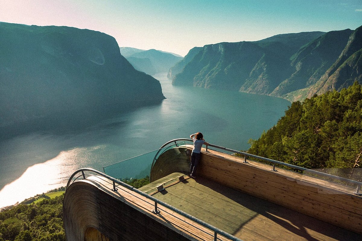
- Skip to main content
- Keyboard shortcuts for audio player
Holmes Chapel, English village of Harry Styles' youth, needs fans to be tour guides
Many tourists visit sites such as a bakery where Styles once worked and a Chinese restaurant where he once dined with Taylor Swift. Tourism has been great for local businesses.
STEVE INSKEEP, HOST:
Good morning. I'm Steve Inskeep.
Holmes Chapel, the English village of Harry Styles' youth, is looking for superfans to work as tour guides. The village gets a lot of tourists, Harries visiting sites like a bakery where Styles once worked and a Chinese restaurant where he once dined with Taylor Swift. The not-for-profit calling for tour guides says tourism has been great for local business, and now it wants to elevate its offerings.
(Singing) Why don't we leave it at that?
It's MORNING EDITION.
Copyright © 2024 NPR. All rights reserved. Visit our website terms of use and permissions pages at www.npr.org for further information.
NPR transcripts are created on a rush deadline by an NPR contractor. This text may not be in its final form and may be updated or revised in the future. Accuracy and availability may vary. The authoritative record of NPR’s programming is the audio record.
Amazon.com Conditions of Use Amazon Privacy Policy © 1996- 2024 Amazon.com, Inc. or its affiliates
International sites
April 17, 2024
Written by Amazon Staff
How to tour Amazon’s Puget Sound headquarters on your next trip to Seattle

Sign up for the weekly Amazon newsletter
Protected by reCAPTCHA. The Google Privacy Policy and Terms of Service apply.
Amazon Privacy Policy | Opt out anytime

Amazon in the community: Here’s what’s happening in Seattle, Bellevue, and the Puget Sound
Learn how we invest in the community, help power the local economy, and support our employees in the Puget Sound region.
IMAGES
VIDEO
COMMENTS
For safety reasons, participants on these tours walk on a rope. In the summer season there are daily guided tours to the top. The trip from Juvasshytta to the top of Galdhøpiggen is about 5 km long - with an increase of 650 vertical meters. The trip is about 12 km. long and takes normally 5-7 hours (round trip from Juvasshytta).
Join us on an exhilarating day tour to conquer Norway's highest peak, Galdhøpiggen (2469 m), via the standard route from Juvasshytta. Experience the thrill of crossing a glacier and ascending a rocky and steep section as you make your way to the summit. At the head of Norway, you'll be rewarded with a magnificent view of the mountain range ...
Hiking trail from Spiterstulen. Galdhøpiggen can also be hiked from the Spiterstulen mountain lodge. The hike is technically classed as easy, but it is still strenuous. That's because the total ascent is around 1,300 metres. In good conditions, it can take around 4 hours up and 2 hours down to cover the total distance of 13 km.
For their guests Raubergstulen offers daily guided tours to Galdhøpiggen, the highest peak in Norway. The tour is suitable for everybody and follows the normal route across the Styggebreen glacier. You need warm clothing and good boots. The tour starts at 09.00 o`clock. Registration the evening before in the reception at the lodge.
Galdhöpiggen, Norway's highest mountain at 2 469m/ 7,100 feet, is situated in Jotunheimen National Park between the lowlands of eastern Norway and the fjords of western Norway. Even though the mountain itself is fairly high, it is relatively easy to climb as it is possible to drive halfway up to Juvass Hytte base camp at 1 840m/ 6,000 feet.
Juvasshytta lies 1850 m.a.s.l., and is a natural starting point for trips to Norway's highest mountain Galdhøpiggen. For safety reasons, participants on theese tours walk on a rope. In the summer season there are daily guided tours to the summit. The trip from Juvasshytta to the top of Galdhøpiggen is about 5 km long - with an increase of 650 ...
During the summer season of 2023, guided tours are available daily at 10 AM from May 26 until September 17. Between July 8 and August 5, there is an additional time slot for 11:30 AM. Snowy and icy conditions can be expected at any time during the hiking season. I hiked the trail in the middle of July and it snowed the night before.
The tour starts in the woods, it leads you to the top of the mountain and Norway! Such ascent providing wonderful variations both in terrain and views. ... In 1850 three men from Lom reached the summit; the guide Steinar Sulheim, the local teacher Lars Arnesen and the church warden Ingebrigt Flotten. Galdhøpiggen Photo by Christian Roth ...
Mountains. Write a review. About. Galdhopiggen is the highest mountain in Norway, 2.469 m.a.s.l. It is also one of the most visited peaks in the country, apart from some hills in more densely populated areas. The hight is fascinating, and Galdhopiggen is also relatively easy to reach. You can follow the normal t-marked route from Spiterstulen 1 ...
Hence, it requires a guided tour and suitable equipment. However, the extra effort is truly worth it, as this trail showcases some of Norway's most stunning glacial landscapes. For those seeking a less strenuous but equally enjoyable experience, the Leirvassbu Mountain Lodge trails offer an array of easier routes, looping around beautiful ...
Season: Guided tours are daily from 1st June till September. Cost of a guided tour (as for 2021): 350 NOK per person . Toll road to Juvashytta: 125 nok for passenger car. ... Glacier on the hike to Galdhoppigen is called Styggebreen, which in Norwegian means "ugly glacier". The problem with glaciers is that there are often cracks and ...
In the summer season there are daily guided tours to the top. The trip from Juvasshytta to the top of Galdhøpiggen is about 5 km long - with an increase of 650 vertical meters. The trip is about 12 km. long and takes normally 5-7 hours (round trip from Juvasshytta). Season: High season from the beginning of June to the Middle of September.
However, it is strongly recommended to take one of the special offers from local tour operators, where a tour guide offers a great insight into nature and the general area. The mountain is surrounded on three sides by expansive glaciers except the east. The Styggebrean Glacier is located to the north, Svellnosbrean Glacier to the south, and ...
Option 2) Spiterstulen to Galdhøpiggen (Most popular without a guide) Option 3) Geitsætre from the western approach (If you don't want crowds) Option 4) Ymmelstinden -> Storjuvtinden -> Galdhøpiggen ridge hike (For mountain climbers) Why you should climb Norway's tallest mountain Galdhøpiggen. The top of the summit.
The trip can be done from Juvashytta or Spiterstulen. Starting at Juvashytta: The hike takes approximately 5 hours. The distance is about 11km and 650 height meters from the start point. Parts of the hike is across the Juvass-glacier and to do this you need a guide and ropes. This you have to book in before you start the hike.
This article is a part of the Ultimate Guide to hiking in Norway. Galdhøpiggen is the highest mountain in Norway, in Scandinavia and Northern Europe. It sits 2469 meters or 8100 feet above sea level. Hiking Galdhøpiggen is not particularly long in distance, but the elevation gain is considerable! Over a rather short distance, you will climb 3 ...
Galdhøpiggen is located in the beautiful Jutunheimen National Park in the Southern half of Norway. It is the highest peak in Norway, Scandinavia, and the Nordic Countries although it is only five metres higher than nearby Glittertind. The mountain is probably the most popular peak to climb in Norway due to its elevation and the fact that it is ...
Save. From Juvasshytta is regarded as a "family trip", although you need a guide across the glaciers. From Spiterstulen is notably more challenging, 5+3 hours. For the relatively fit and experienced "summit hiker". As a rule of thumb 300 or 400 meters/hour. Report inappropriate content.
Galdhøpiggen is Northern Europe's highest mountain, reaching 2469 meters above sea level. The mountain is a national symbol of Norway situated in the heart of Norway - in the middle of the alpine and breath taking nature in Jotunheimen National Park. Hiking to Galdhøpiggen is one of the country's most popular mountain hikes, and can be done ...
I'm Steve Inskeep. Holmes Chapel, the English village of Harry Styles' youth, is looking for superfans to work as tour guides. The village gets a lot of tourists, Harries visiting sites like a ...
In the summer season there are daily guided tours to the top. The trip from Juvasshytta to the top of Galdhøpiggen is about 5 km long - with an increase of 650 vertical meters. The trip is about 12 km. long and takes normally 5-7 hours (round trip from Juvasshytta). High season from the beginning of June to the Middle of September.
If you need to ring them up for more deets or to secure your spot, the Marietta History Center can be reached at 770-794-5710 or peep their site at www.MariettaHistory.org. Marietta City Cemetery ...
This round trip is 13 km. long, with an increase of 1520 vertical meters. The trip usually takes between 7 - 9 hours and can be done with "young mountain hikers" down to the age of 5-6, if they are motivated. Hike to the top on your own or with a guide: The trip from Spiterstulen to Galdhøpiggen can be done both with and without a guide, and ...
Amazon Puget Sound Headquarters Tour map. You can now tour Amazon's Puget Sound headquarters campus. The new, self-guided experience shares information about the company and its history as you walk through its urban Seattle campus and landmarks. Scan a QR code at one of the 15 Amazon Puget Sound Campus Tour signs for information.