- Department of Tourism

+91-80-2235 2828
Sign up to newsletter

- Kavaledurga Fort
Kavaledurga is a fort resting on the top of a hill amidst a dense forest and it requires a trek of at least 5 km to reach the summit. A spectacular combination of history and natural beauty, several shrines to Virupaksha, Vijaya Vittala, Veerabhadra, Mallara and Bhuvaneshwari are housed in the fort. Besides the ruins and an old palace, a mosque built by Venkatappa Nayaka can also be found here. It is also a scenic spot to view the sun setting in the Arabian Sea.

Why visit Kavaledurga:
- Impressive fort structure: Kavaledurga Fort has 3 rounds of rock wall fortifications and was a stronghold of the Keladi Nayakas (an important ruling dynasty of Karnataka and the subordinates of Vijayanagara empire) during the 16th century.
- Explore temples and palace remains : Kavaledurga Fort, also known as Bhuvanagiri now has some remains of a palace, bath, guard rooms and weapon storage houses. A freshwater pond on top of the fort is in excellent condition. One can visit the Srikanteshwara temple and Nandi Mantapa that are situated on the hill.
- Hiking & Trekking Experience: Hiking till the top of Kavaledurga Fort will be a great exercise. Trekking could also be an option to Sahyadri hills when safe.
- Enjoy Great Views: On clear days offers amazing views of beautiful Sahyadri hills
Visiting Details:
- Exploring Kavaledurga takes two to three hours of time for those who are physically fit.
- Entry to Kavaledurga closes by 5 PM.
- There are not many facilities available at Kavaledurga except for a tea shop near the parking area. Do carry essentials like water.
Nearby Destinations: Kavaledurga is a great place for a weekend trip from Shivamogga or Thirthahalli town, covering nearby destinations like Kavishaila (Jnanapeetha award-winning poet Kuvempu’s home), Agumbe (where the famous movie Malgudi days was shot), Kundadri Hills (sunrise point), Gajanur dam and Mandagadde Bird Sanctuary.
How to reach Kavaledurga:
Kavaledurga is located at 18 kms from the nearest town Thirthahalli, 133 kms from Mangaluru, 365 kms from Bengaluru.
By Train: Shivamogga is the closest train station that is 72 kms away.
By Road: There are no direct buses connecting to Kavaledurga.
One will either have to travel from Bengaluru to Shivamogga(approximately 300 kms) by bus or Bengaluru to Thirthahalli(approximately 346 kms) which are both direct buses.
The nearest town closest to Kavaledurga Fort is Thirthahalli which is about 18kms away(approximately 30 minutes to reach the Fort).
Otherwise, about 79kms and almost 1 hour away is Shivamogga to Kavaledurga Fort.
By Air: The nearest airports to Shivamogga are Hubli, Mangalore International Airport Kempegowda International Airport, Bengaluru and lastly Goa International Airport. The following is listed based on the distance from the destinations to the airport.
Transportation Facilities to Kavaledurga: Public transportation is available from both Shivamogga to Kavaledurga Fort and Thirthahalli Fort. You may also opt for local taxis or hire KSTDC(Karnataka State Tourism Department Corporation) buses and cars from Bangalore.
Places to stay near Kavaledurga Fort:
Thirthahalli town offers multiple hotels. Several home stay options are available in and around Thirthahalli and Shivamogga.
Tour Location
Leave a reply cancel reply.
Save my name, email, and website in this browser for the next time I comment.
Kavaledurga Fort
Top ways to experience nearby attractions
Most Recent: Reviews ordered by most recent publish date in descending order.
Detailed Reviews: Reviews ordered by recency and descriptiveness of user-identified themes such as wait time, length of visit, general tips, and location information.

Kavaledurga Fort - All You Need to Know BEFORE You Go (2024)
- (9.24 mi) Belachikatte Homestay
- (5.84 mi) The Highlands
- (4.84 mi) Muduvalli Heritage Homestay
- (9.92 mi) Amthi Homestay
- (6.26 mi) Kamath Residency
- (3.63 mi) Talasi Abbi Falls
- (7.30 mi) Nagara Fort
- (8.02 mi) Kavimane

- Kavaledurga Fort Trek In Shimoga
- architectural beauty
- July 11, 2020 July 24, 2020
- Suraj Kumar Manohara
- architectural beauty , Historical Forts , Shimoga , Trekking and Hiking

Kavaledurga is a hidden gem that showcases the rich history of Karnataka and it is located near Thirthahalli town, Shimoga. This Fort in western ghats is perched on top of a hillock at about 1,541 meters above sea level. It is a beautiful fort with architectures hidden behind misty clouds and pools filled with blueish water. Not just architecture, this place is also popular among nature lovers and trekkers who wish to get lost amidst nature. Kavaledurga is a short trek of 3 Km to the peak and it might take about 2 hours to reach the summit. Above all, in most parts of the trek, you will be walking through the thick mist-filled clouds.
Table of Contents
Kavaledurga Trek

Initially, you will be walking a few yards through a stretch of green paddy fields. After that, you will come across a wooden gate passed by a well-paved stone pathway that leads you to the fort entrance. All the walls of the fort are covered with green grass and patches of fungus. While hiking you will notice tiny waterfalls that join the streams beneath the hill.
After about 45 mins of the trek, you will enter the 4th entrance of the fort. And you will be stunned by the beauty of the ancient temple and the tiny pond behind it. If you move further up you will come across remains of a huge huge palace on the top of the hill. Most of the travelers don’t go beyond this point as it appears like a peak. Actually, that is not the case, the best surprise awaits you only beyond this point.
You need to take a muddy track that is steep and narrow amidst thick forest trails to reach the peak. In fact, the view of the fort, wandering streams, panoramic view of the valley, a stretch of greenery filled rolling hills, and misty surroundings make this place look like heaven on earth.
No eateries or shops, except for a small shop near the entrance that serves snacks and water bottles. Hence, it is always better to carry your packed food when you are heading to Kavaledurga.
History And Architecture Of Kavaledurga Fort

Kavaledurga fort acted as the fourth and last capital of the Keladi Dynasty. This fort was built in the 9th century and was later restructured by Cheluvarangappa in the 14th century. In Total, there are about 7 entrances or gates to the fort. As you enter the gates What you can see are ruins and remnants of a long-lost kingdom that had rich cultural and traditional essence in the past.
There is a popular Kashi Vishwanatha Temple with two huge pillars on the top of the hill, dedicated to Lord Shiva. It is built in a typical Keladi style of architecture. This temple has carvings of snakes, elephants, warriors, birds, sun, and moon on the outer walls.
In addition to that, you can spot a lot of ponds filled with blueish-green water at various stages of Fort. In fact, these ponds were used to store water in the olden days. These ponds have well laid out steps, to make the process of water fetching easy.
You will even come across a cave that holds years of freshwater in it. Apparently, as per legends, Bheema of Pandavas during their exile period had dug the cave using his “Gadaa”.Hence, these caves are known as” Gadaa Theertha”.
Apart from this, you will also come across the ruins of a huge palace. You can witness remains of the palace in the form of hundreds of stone pillars that are widely spread over a large area. By observing it properly, you will be able to easily distinguish between darbar hall, ammunition room, jail, kitchen, pooja room, and swimming pool in the backyard of the Palace.
How To Reach Kavaledurga Trek Point
Thirthahalli is 18 Km away from Kavaledurga and it is the only major town near Fort. There are plenty of buses to Thirthahalli from Agumbe, Shimoga, or Udupi. After you reach Thirthahalli you can hire an auto-rickshaw or jeep to reach the fort.
Kavaledurga Trek Information
Entry Fee: NA
Timings: 7 Am to 5:30 Pm
Trek DURATION: 3 TO 4 Hours
Trek Distance: 6 Km( to & fro)
Camping: Not Allowed.
Location: 18 Km From Thirthahalli
Distance From Bangalore: 365 Km
Also, read: Hidlumane Falls Trek
About Author

Leave a Reply
Post Comment
Kavaledurga
Tags : Forts & Palaces
Timings : 8:30 AM - 5:30 PM, Everyday
Entry Fee : INR 5
Planning a Trip? Ask Your Question
Kavaledurga, Shimoga (Shivamogga) Overview
Kavaledurga is ancient hill fort situated near Shimoga in Karnataka that is perched at a height of 1541 metres. Although in ruins right now, the hill fort is still considered to be one of the most scenic and enchanting places in the state. Engulfed in greenery, the fort is surrounded by the majestic Western Ghats. The heritage spot is a hidden secret in the region and therefore is devoid of the typical tourist crowd. The fort can be reached through a trek uphill that might be a little tiring but the view at the top will make it all worthwhile.
Read More on Kavaledurga
Architecture of the kavaledurga fort.
The sturdy walls of the mighty fort are 30 to 40 ft in height and have been made out of granite blocks. Boasting of an 8 km long circumference, the fort also has watchtowers and two types of defence. Besides, there are several water channels that gather natural flowing water from the mountain and provide it to the fort.

Recently, there were several excavations carried on in the fort because of which several structures have been unearthed. These include swimming pools, ammunition house, jail, horse and elephant stables, veranda, kitchen, pooja room and a Durbar Hall etc. The highlight of the fort, however, is a cave called Gadaa Theertha, which also has a small pool next to it.
Temples of Kavaledurga Fort

- Kashi Vishwanatha Temple is situated a little downwards and is known for its Islamic style doorway and the two pillars flanking the entrance.
Trek to the Kavaledurga Fort
You can reach the base or the starting point of the trek i.e. Kavaledurga. It is not a very difficult trek and can be undertaken by both amateurs and professionals. You can also hire a guide for the same. There are stairs on the way to make the hiking easier. Besides, the ever-changing topography on the way is remarkable.

From scintillating views of the jungle to the mighty mountains, the trek offers some of the most stunning vistas. It takes a total of around 3 hours to reach the top. At the entrance of the fort, there are ruins of a gate. Further, you can see carvings, remains of ancient temples and dilapidated bastions and idle gun slits. Then there is a second, third and fourth gate, after which you can reach the top of the fort.
How to Reach
Top hotel collections.

5 Star Hotels
Cheap Hotels
Top Hotels Near Kavaledurga
8.5 (548 reviews)
54 kms
₹ 2,880 onwards
7.0 (166 reviews)
55 kms
₹ 4,000 onwards
7.1 (126 reviews)
₹ 1,100 onwards
Kavaledurga Reviews
Have a question on kavaledurga.
Nearby Places
Related Posts
Sightseeing
Mesmerising Waterfalls in Shimoga for a Natural Retreat
Places to Visit near Shimoga
Wildlife & Nature
Things to Do in Shimoga
Rainforests and Waterfall Trekking Await You At This Quaint Town In Karnataka
Short Trip to Shimoga #TWC
Similar Places
Get the best offers on Travel Packages
Compare package quotes from top travel agents
- India (+91)
*Final prices will be shared by our partner agents based on your requirements.
Log in to your account
Welcome to holidify.
Forget Password?
Share this page
Kavaledurga Fort
Top ways to experience nearby attractions
Most Recent: Reviews ordered by most recent publish date in descending order.
Detailed Reviews: Reviews ordered by recency and descriptiveness of user-identified themes such as waiting time, length of visit, general tips, and location information.

Kavaledurga Fort - All You Need to Know BEFORE You Go (2024) - Tripadvisor
- (14.79 km) Belachikatte Homestay
- (9.35 km) The Highlands
- (7.74 km) Muduvalli Heritage Homestay
- (15.88 km) Amthi Homestay
- (10.01 km) Kamath Residency
- (5.80 km) Talasi Abbi Falls
- (11.67 km) Nagara Fort
- (12.84 km) Kavimane

Buried Beneath the Ruins is Kavaledurga
Kavaledurga Fort: Where History Echoes Amidst Tranquil Wilderness. Explore the intriguing tales of a centuries-old stronghold nestled in the heart of Karnataka's breathtaking landscape
8/4/2023 6 min read

In Karnataka, close to Thirthahalli, Shimoga is the historic hill fort of Kavaledurga, which is perched at a height of 1541 metres. Even though it is currently in ruins, the hill fort is nevertheless considered as one of the state's most picturesque and fascinating locations. The majestic Western Ghats encircle the fort, which is surrounded by lush greenery. The heritage site is a well-kept secret in the area, so there aren't any normal tourist crowds there. The climb uphill to the fort may be a little exhausting, but the view from the top will makes it all memorable.
Manipal - 83Kms
Bangalore - 366kms
Timings: 8:00am-5:00pm
Best Time to Visit : August-March
(As per the local guide)
Weekends: 100-250 people per day
Weekdays : 50-100 people per day
Summer : 20-50 people per day
Trek to the Fort:
Distance : 5km Up and Down
Difficulty : Easy to Moderate
Time : 2hr -2hr 30 mins Up and Down

You will have to park the car in the end of the Tar Road and bike can go 100m ahead where you will see a pond and you can park the bike there and start walking. Once you start walking you pass through a narrow walking way towards a wooden gate which acts as the trek's base or beginning point. the trek is not extremely tricky nor easy you will have mixture of stairs and plain rock way; the rock ways are slippery and turns out tough to climb when it rains. In addition, the spectacular topography along the route is always changing from enthralling views of the jungle to the mountain ranges. The journey up takes about 3 hours in total. Ruins of a gate can be found near the fort's entrance. Additionally, there are carvings, ancient temple ruins, decaying bastions, and empty gun slits to be seen. After passing through the second, third, and fourth gates, you can climb to the summit of the fort.
The fort has 3 parts the entrance gate, temples and palace. Once you reach the Shikareshwara Temple you will have have 2 ways of 500m, one leading to The Lakshmi Narayan Temple and the other toward the ruined Durbar Hall. The way to the palace is closed now (16th June, 2022) as there has been a land slide on the way.
How to Reach:
From Bangalore:
If you are going with your own vehicle or cab the shortest and good road route is through Hiriyur-Hosadurga-Shivamoga-Thirthahalli-Kavaledurga. If you want a road with scenery then you can take the Hassan-Belur-Sringeri-Kavaledurga route.
If you are coming in public transportation the you will have to take a bus directly to Thirthahalli and hire an autorickshaw. If you are looking take a train the nearest train station is in Shivamogga, from there you will have to take a bus to Thirthahalli.
From Manipal:
If you are going with your own vehicle or cab the shortest and good road route is through Manipal-Hebri-Agumbe-Kavaledurga which will be 83 Kms, in this route you will be able to see the beautiful view from the agumbe view point but in monsoon the best route will be through Manipal-Brahmavara-Nandagoli-Siddapura-Hulikal Ghat-Kavaledurga which will be 98km, in this route you will through Hulikal Ghat you will be able see Hulikal Falls, view point and Talasi Abbe Falls along the way.
If you are looking out for public transportation then you will have to take a bus to Thirthahalli and hire an autorickshaw from there.

History of Kavaledurga Fort:
Kavaledurga was constructed in the 9th century, and Cheluvarangappa renovated it once again in the fourteenth. The fort had witnessed a number of powerful and honourable Keladi rulers who were well-known figures throughout the Vijayanagara Kingdom's feudal era. Venkatappa Nayaka (A.D. 1582–1629) fortified the area here after the Vijayanagara Kingdom collapsed, built a palace, and turned it into an agrahara with a Mahattina Matha , a Sringeri Matha , a treasury, a granary, stables for elephants and horses, and ponds. The Kavaledurga location has a strong connection to Hindu mythology, which describes it as Parashuram Kshetra. Additionally, it is thought that Agastya and the well-known Hindu sage Maharshi Valmiki spent a substantial period of time here.
This fort had previously gone by the names "Kaurava Durga," but Dodda Sankanna Nayaka of the Keladi dynasty changed its name to "Bhuvanagiri." He strengthened and refurbished the walls. In this fort, Keladi Rani Chennamma was crowned. From this fort, Keladi rulers ruled their empire for 60 years. Additionally, it is stated that Rani Chennamma defended Shivaji's son Rajaram from this fort and defeated the powerful Mughal army.

Architecture of Kavaledurga Fort:
The Kavaledurga fort is surrounded by three lines of wall constructed of massive granite blocks that mimic the hillock's natural contour. Each fortification has an entrance that is flanked by guard rooms on either side. Between the gates are temples, a palace site, and a basement of structures. Nearly at the middle of the Hills' peak, Shikhareshvara or Srikanthn eshwara Temple is a small temple with views of the Western Sea. A grand terraced edifice with an elaborate basement makes up the palace site within the fort. Recent clearance in the region as revealed bare sequence of interconnected chambers within a large inner quadrangle all of that is provided with A spacious enclosed verandah leading to a tiered tank and a kitchen with a five-burner stone oven, as well as the platform in the bathroom with a unique water supply system, give an understanding of the architecture style of the place.

Temples at Kavaledurga Fort
There were originally 15 temples in the fort, but only three remain: Lakshmi Narayan Temple, Kashi Vishwanatha Temple, and Shikareshwara Temple.
The Lakshmi Narayan Temple is located at the top of the hill. It is accessible via a flight of stairs and a tricky trek over a short distance that leads to the most stunning view of the western ranges.
Shikareshwara Temple is located in the heart of the fort and provides a panoramic view of both the fort and the valley. Temple includes the Garbhagriha , a Nandimandapa , and an entryway leading to a porch with a beautiful view of the sun setting beyond the western horizon.
Kashi Vishwanatha Temple is located slightly lower down and is notable for its Islamic-style doorway and two pillars flanking the entrance.

Things to Look Out For:
Most of the year, this area is covered in lush greenery, and it is also home to snakes, spiders, and many other insects. We didn't see any snakes, but we did spot two snake-shade skins. What's intriguing is that we spotted one on a wall surrounded by rocks and the other on the top of a hill, above the Lakshmi Narayan swamy statue. Built in the ninth century, this location's design is incredibly captivating. It has chambers for lamps and grinding stones, and since it frequently receives rain, it has a water channels that runs down a hill to form a small pond on the top of the fort. you can also witness the old drainage system along the trek path. The fort is now only ruins, but all throughout it you can see several solitary idols and pillers. One such idol was an isolated Nandi facing nothing, which is quite uncommon in Hinduism.
I would recommend you to take your own food and water as there are no hotels or restaurants available near the fort. There are 2 shops near the parking area but they only have local company juices and snacks. The nearest town is Thirthahalli where u will find hotels to stay and you can find plenty of restaurants there.

Kavaledurga is a magical fort that has everything a traveller could ask for in a visit. History that captivates you with some breath-taking tales. Architecture can enthral you with incredible architectural styles, temples, old utensils and stunning sculptures. You may enjoy amazing views of the Sahyadri Mountains throughout the trek. And to top it all off, the region is surrounded by an unparalleled, incredible amount of calmness. The magnificent heritage of this country and the tremendous spiritual peace meet together. with all this Kavaledurga is the perfect getaway and a stress reliefer from the busy life in the urban world.

Kavaledurga Fort Location:
Top 5 Attractions Near by:
Agumbe/ Kudlutheertha falls- 36kms
Kundadri- 31kms
Jogigundi- 38kms
Onakeabbe falls- 34kms
Talasi Abbi falls- 13kms
Subscribe newsletter
- Media Kit |
- Get My Counsel

- Travel Tips
- Love or Hate India?
- Must Dos on your India Holiday
- India on a Motorcycle
- Off-beat Honeymoon Destinations
- Wildlife Holidays
- Birding Holidays
- Motorycling Holidays
- Motorcycling India's Highest Villages
- Top Things to do in Jodhpur
- Riding to the Top of the World
- Iconic Vegetarian Street Food Joints of Hyderabad
- Iconic Vegetarian Food Joints of Jaipur
- Traditional Food Trails of Mumbai
- Top Things to do in Dandeli
- Top Summer Weekend Getaways from Bangalore
- 48 Hours in Agra
- Top Things to do in Bikaner
- Top Monsoon Treks from Bangalore
- Traditional Food Joints of South Bangalore
- Top Things to do in Jaisalmer
- Top Monsoon Holidays in Karnataka
- Top Food Experiences of Amritsar

- Vegetarian Travel Guide
Monday, October 05, 2020
Kavaledurga fort: 9th century historical trekking destination nestled in the lap of the western ghats.


- Counselling
- My Public Talks
Post a Comment
Do what you love, my first ted talk: tedx iit guwahati.
This is for all those people out there who wish to live their dream, but for some reason choose not to…Hopefully, this post will charge your...

Currently Trending

Blog Archive
- ► March (3)
- ► February (1)
- ► January (6)
- ► December (1)
- ► November (4)
- ► October (4)
- ► September (1)
- ► August (4)
- ► July (5)
- ► June (5)
- ► May (4)
- ► April (6)
- ► February (4)
- ► January (1)
- ► December (5)
- ► August (1)
- ► July (4)
- ► June (2)
- ► May (3)
- ► April (3)
- ► January (3)
- ► December (2)
- ► November (2)
- ► October (2)
- ► September (5)
- ► August (5)
- ► May (2)
- ► March (5)
- ► February (7)
- ► January (5)
- ► December (6)
- ► November (6)
- The Sweet Journey: From inside a sugarcane factory...
- Mirjan Fort: The 16th century structure that is ta...
- Magod Falls: A Colossal Monsoon Spectacle
- Devimane Ghat: Monsoon Beauty home to Medicinal Pl...
- Traveling Eastern Europe
- The Green Motorcycle Ride: A Photo Story
- Kallu Ganapati Temple: Offbeat Rustic Gem near Udupi
- Travel itinerary if you won the Indian Lottery
- Unchalli Falls: Stunning Monsoon Holiday Destinati...
- Five great ways to use your best travel photos
- Bilihole Falls: Hidden Waterfall amidst the untouc...
- Lakshmi Narasimha Temple at Nuggehalli: 13th centu...
- Kavaledurga Fort: 9th century historical trekking ...
- ► July (2)
- ► June (4)
- ► May (5)
- ► April (9)
- ► March (6)
- ► February (11)
- ► January (2)
- ► December (7)
- ► November (12)
- ► October (8)
- ► September (7)
- ► August (11)
- ► July (13)
- ► June (9)
- ► May (11)
- ► March (8)
- ► February (12)
- ► January (8)
- ► October (11)
- ► August (8)
- ► July (6)
- ► June (8)
- ► April (5)
- ► February (10)
- ► October (6)
- ► September (8)
- ► August (3)
- ► July (11)
- ► May (9)
- ► April (11)
- ► March (11)
- ► January (7)
- ► October (9)
- ► September (3)
- ► August (13)
- ► May (13)
- ► March (12)
- ► February (42)
- ► January (40)
- ► December (9)
- ► November (11)
- ► October (5)
- ► September (11)
- ► August (15)
- ► July (17)
- ► June (28)
- ► May (20)
- ► April (22)
- ► March (19)
- ► February (28)
- ► January (10)
- ► December (8)
- ► November (20)
- ► October (29)
- ► September (22)
- ► July (22)
- ► June (22)
- ► May (25)
- ► April (18)
- ► March (20)
- ► February (18)
- ► January (23)
- ► December (22)
- ► November (15)
- ► October (37)
- ► September (26)
- ► August (26)
- ► July (31)
- ► June (35)
- ► May (33)
- ► April (31)
- ► March (39)
- ► February (33)
- ► January (43)
- ► December (48)
- ► November (35)
- ► October (34)
- ► September (38)
- ► August (14)
- ► June (11)
- ► May (21)
- ► March (26)
- ► February (13)
- ► January (14)
- ► September (13)
- ► July (10)
- ► June (17)
- ► May (19)
- ► April (20)
- ► March (27)
- ► January (39)
- ► December (30)
- ► October (42)
- ► September (46)
- ► July (57)
- ► June (21)
- ► May (28)
- ► April (47)
- ► March (34)
- ► February (5)
- ► January (15)
- ► December (29)
- ► November (17)
- ► October (38)
- ► September (37)
- ► August (7)
All Time Favorites

Popular Posts

- blogs: india
- blogs: worldwide
- newsletter signup
- linkedin profile

Kavaledurga Fort, India: The Western Ghat's Hidden Gem

India Writer
In the Western Ghats near Karnataka , at a prodigious altitude of 1,541 meters, lies the majestic Kavaledurga Fort, a truly beautiful landscape of mountains, forest land and rivers. The best way to explore this scenic environment is via an uphill trek, which isn’t an easy one, but the gorgeous views and abundant natural beauty make it worth the effort. Here’s everything you need to know about this incredible hidden gem.
Located approximately 11 miles from the town of Thirthahalli in the Shimoga district of Karnataka, the Kavaledurga Fort is a stunning site wrapped in tales of a bygone era, which makes it a must-visit for history buffs. Plus, owing to its location on the top of a hill amidst the rolling hills and lush jungles, it is a paradise for adventure enthusiasts looking for high altitude kicks.
A brief history
Established in the 9th-century, the Kavaledurga Fort over the centuries has witnessed the reign of different rulers – from the Cheluvarangappa (king of Belagutti) in the 14th-century who renovated it, to the Nayakas of Keladi in the 16th-century, who fortified the fort by building seven bastions, and further in 1763, the fort was occupied by Hyder Ali and Tipu Sultan. Each ruler added some unique architectural elements to the fort, which remain evident in the modern day.
Today, the fort lies in ruins, but continues to stun visitors with its exceptional architecture and historical vibe. With a backdrop of the Western Ghats and surrounded by lush greenery, the fort is constructed of granite blocks, complete with nine to 12 meters high fort walls and seven levels with a gate at each level. Within the fort were originally 15 temples, of which only three are left. Besides this, there are remnants of a forgotten era, including stone artefacts, and ruins of a palace, stables of horses and elephants and other relics.
According to legend, many sages did penance on the hills surrounding the fort. In Hindu mythology, this spot was called as Parashuram Kshetra, which gained prominence in the Krita Yuga. It is believed that sages Valmiki and Agastya lived here for a while. Also, legend has it that the Pandavas stayed here for quite some time during the Dvapara Yuga. All this contributed to its popularity among those seeking spirituality and peace of mind.
http://instagram.com/p/BOfUEPmg9qR/
The trek to Kavaledurga Fort
You can take a cab or bus from Thirthahalli, or drive yourself to the trailhead for the fort hike, i.e Kavaledurga. The trek is best described as moderate, and can be done on your own or with a guide. The hiking route is short, and is accessible by stairs, with swathes of scree, which makes the trek strenuous. However, there are changes in the ecosystem along the way, from lush jungles to scenic mountains, which makes it all the more worthwhile.
It takes around three hours or so, with brief intervals in between, to reach the summit of the fort, which is set atop a hill.Aim to be at the hilltop during sunset as the views are breathtakingly beautiful and will leave you awestruck. Do not forget to take your camera!
http://instagram.com/p/BcFFZK4HAcU/
What to expect
With a circumference of eight kilometres, the fort covers a considerable area. At each gate (total, seven levels), you will be treated to immense beauty and the relics of the bygone era. The third gateway leads you inside the precincts of the Kavaledurga Fort. As you enter the fourth gate, you will come across the ruins of ancient temples, including the Kashi Vishwanath Temple that stands out with its intricate carvings of the armed warriors, the sun and the moon, birds, elephants and snakes on the outer wall; the Lakshminarayana Temple , which is a small shrine resting on a weathered rock, amidst the lush greenery; and the Shikareshwara Temple .

Further climbing uphill, you will find stepped wells and stone artifacts, including the statue of Nandi. As you move further, you will encounter ruins of a palace, complete with about 1,000 pillars, courtyards, verandahs and swimming pools.
As you reach the summit of the magnificent Kavaledurga Fort, you will be greeted with the jaw-dropping vistas of the Western Ghats and the Varahi and Chakra Rivers. Within the precincts of the Kavaledurga Fort also lies the beautiful water channels, as well as a cave with a pool of fresh water, which is called ‘Gadaa Theertha’ as it is said to be dug by the gadaa (mace) of Bheema from the epic poem, Mahabharata.
Pro tip : Pack water bottles and energy bars to take with you. Be sure to wear sturdy trekking shoes!
http://instagram.com/p/BdnShNengfK/
Essential visitor info
Accommodation : There is no stay option available in Kavaledurga. Visitors can stay at Thirthahalli, Shimoga or Agumbe, which are close by.
Best time to go : You can trek to the Kavaledurga Fort all year-round, however, the best time is between August and April.
How to get to Kavaledurga: The nearest railway station is Shimoga, approximately 51 miles from Kavaledurga – take a cab/taxi the rest of the way. Or you can hire a taxi from Thirthahalli, which is located approximately 11 miles from Kavaledurga Fort.
Location : Kavaledurga, Thirthahalli, Shimoga, Karnataka, India
Opening hours : 8:30am-5:30pm
Entry fee : INR 5

KEEN TO EXPLORE THE WORLD?
Connect with like-minded people on our premium trips curated by local insiders and with care for the world
Since you are here, we would like to share our vision for the future of travel - and the direction Culture Trip is moving in.
Culture Trip launched in 2011 with a simple yet passionate mission: to inspire people to go beyond their boundaries and experience what makes a place, its people and its culture special and meaningful — and this is still in our DNA today. We are proud that, for more than a decade, millions like you have trusted our award-winning recommendations by people who deeply understand what makes certain places and communities so special.
Increasingly we believe the world needs more meaningful, real-life connections between curious travellers keen to explore the world in a more responsible way. That is why we have intensively curated a collection of premium small-group trips as an invitation to meet and connect with new, like-minded people for once-in-a-lifetime experiences in three categories: Culture Trips, Rail Trips and Private Trips. Our Trips are suitable for both solo travelers, couples and friends who want to explore the world together.
Culture Trips are deeply immersive 5 to 16 days itineraries, that combine authentic local experiences, exciting activities and 4-5* accommodation to look forward to at the end of each day. Our Rail Trips are our most planet-friendly itineraries that invite you to take the scenic route, relax whilst getting under the skin of a destination. Our Private Trips are fully tailored itineraries, curated by our Travel Experts specifically for you, your friends or your family.
We know that many of you worry about the environmental impact of travel and are looking for ways of expanding horizons in ways that do minimal harm - and may even bring benefits. We are committed to go as far as possible in curating our trips with care for the planet. That is why all of our trips are flightless in destination, fully carbon offset - and we have ambitious plans to be net zero in the very near future.

Film & TV
Embrace the barbie spirit by visiting the world's most colourful cities.

Guides & Tips
Top tips for travelling in india.

The Best Places to Travel in November

See & Do
The top things to do and see in jaipur.

Fun-Filled Travel Experiences to Boost Your Serotonin Levels

Photo Journal: 10 Photos From Jaipur's Ganguar Festival

5 Delicious Indian Dry Bean and Lentil Recipes

This Homestay Could Help Save Rajasthan’s Nomadic Camel Pastoralists

How To Spend a Week in Maharashtra

How to spend 10 days in Madhya Pradesh, India

Simran Lal, Founder of Nicobar, On How She Launched Her Lifestyle Brand and Tips On Travelling to India

A Guide To Madhya Pradesh’s Tiger Reserves
Winter sale offers on our trips, incredible savings.

- Post ID: 1815046
- Sponsored? No
- View Payload

Kavaledurga fort trek; Monsoon in Agumbe
Kavaledurga fort is a hill fort near to Agumbe, which is the wettest place in South India. When I visited Agumbe, the monsoon was at its best in the subcontinent. What else is the best time to visit such a place. We had to cancel our journey initially due to the landslides in the ghat road to Agumbe. Waited for few weeks but there was an uncertainty in our journey till we reach there.It was continuously raining from the time I got down in Agumbe till we boarded our bus back. As a person who loves monsoons, Agumbe made me really happy. The rain is so beautiful here. The best moments of the journey was undoubtedly the Kavaledurga fort trek.

It was my first day at Agumbe. The major attractions here are the waterfalls, all of them closed due to the heavy rain. My friend Alex was also with me. We were staying in Agumbe and the rain had no intention to stop. Made our plans immediatley, wrapped our phones and wallet in a plastic cover, jumped out in to the rain and ran to the bus station to catch a ride to Thirthahalli.
From Thirthahalli, an auto took us to the start of Kavaledurga fort trek. It was a small village, few houses here and there, vast flooded green paddy fields. Few were working in the fields hiding from the rain under their raincoat. The people in the shop at the entry offered us those raincoats when they saw us drenched in the rain. We said no. We are here to be in the rain, to get wet as much as possible, to witness the nature’s most beautiful phenomenon and to walk in the muddy water.

The initial stretch of Kavaledurga fort trek is through the paddy fields. Once you cross the fields, there will be a small wooden gate and you can see the stone paved roads up to the hills. The trek is not that difficult. May be during rains, the rocks will be slippery. That’s the only thing we should keep in mind while walking. The hill is forest covered, all you can hear is sound of water drops. My thoughts went back to the monsoon trek in Kodachadri last year.

Walk for 30 minutes, you reach the first entrance of the fort. You will realise that the fort was not that small. The fort has a layers of such entrances. The construction of Kavaledurga fort is amazing. How those people built such an enormous fort on the top of the hill, a question that is still in my mind. After the entrance, you reach a temple with two long pillars at its front. I was walking around the temple, suddenly my attention went to the pond behind it. The water was emerald in colour. The pond was big, there was stairs down to the pond. Huge trees were lining all the four sides of the pond. It was full of small ripples as the rain drops falls over the leaves to the water.

We can see some more tanks like these as you hike further. These water tanks are the speciality of the Kavaledurga fort. They are built very beautifully. All the tanks were full with water upto the brim. There are narrow underground channels which connects the tanks to maintain the water at a particular level.
Once we walk past the initial structures of the fort, we can see bunch of stone pillars, standing up, widely spread over a large area. Those are the remains of the palace, found out during a recent excavation. We can easily identify the main hall of the palace by the placement of the pillars. From the site, I can imagine the size of palace, it is big enough for a place like this. There is another pond behind the palace, which have a peculiar shape.I guess that might be the king’s swimming pool.

The fort was almost deserted at that time, everyone left since it was raining heavily. The forest cover will get more thick after the palace ruins.There is a trail up to the top but very few only hikes up furthur. We decided to go up. The trail will become more steep as you reach the top. But once you are there, you will realise that, it was worth coming. To see the complete beauty of this fort, I would suggest you to trek till the top.

I felt so happy when reached up there. The rain, the views from the top and the ruins of the fort; all of them together was magical.
We decided to walk back,as it was getting dark. Back at the entrance gate, celebrated our hike with a hot coffee. It was still raining and we were not worried about it anymore. Back to Agumbe.
How to reach Kavaledurga fort
You will be visiting Kavaledurga fort from Agumbe most probably. You need to reach Thirthahalli first, it is about 25 km from Agumbe. During day time, lot of buses are available passing through Thirthahalli. Thirthahalli is a comparatively bigger town. From there, you can reach Kavaledurga fort either by bus or auto. Getting a bus is totally depends on your luck. There are no frequent buses. Ask someone there, they can help you with the bus timings. Or else you can take an auto rickshaw to Kavaledurga fort, it will costs around 300 INR.

For coming back, buses are there but be sure with the timings. Better ask for bus timings at the shops in the entrance and plan your trek according to it.
We hired an auto rickshaw from Thirthahalli and took the driver contact number. On the way back, since we missed the bus,called the same guy to pick us.
Few things to keep in mind before Kavaledurga fort trek
Kavaledurga fort trek is not at all a difficult trek. Everyone can do it, the only thing is that you need to climb up a hill through the stone paved roads.
I would suggest you to visit Kavaledurga during monsoons, it will be an amazing experience.
If you are trekking in monsoon, the rocks will be slippery, so be careful and bring a nice hiking shoes.
The forests of Agumbe is known for snakes and I won’t suggest you to venture more into the forest out of curiosity. The forests are totally strange for us who lives in the cities, so it is good to avoid snake encounters.
There are few shops at the entrance of the trek, you can buy something to eat from there but don’t put the wrappers inside the fort. We should keep this place clean and moreover it is forest. A little conscious about these things can bring a big change, I believe.
The gate to Kavaledurga fort will get closed by 5.30 PM. The people at the gate won’t allow you to enter after that time. So plan your trek accordingly.

If you are trekking in the rain, better don’t take your phones or cameras, it will be a burden for you. All the time, you will be thinking about it, whether it gets wet, and that will definitely spoil the vibe. Else bring plastic covers to keep them safe.
From the ruins of palace, you can further trek up to the top. The trail will be little steeper and you need to walk through dense forest. But the views from the top was stunning. And I would suggest you to definitely hike to the top if it is possible.
That’s all about Kavaledurga fort trek. Do visit this fort when you are in Agumbe. Agumbe is one of the must visit place in Western ghats, the rain here is really amazing.
Read more: my journeys in Western ghats
Do follow our pages in Facebook and Instagram, please help to grow this community of like minded travelers.
If you have anything related to ask about Kavaledurga fort trek, use the comment box below. I can hep you. Please let me know your feedbacks too.
Thanks for your support,
Keep travelling…
Pin and read later

- Recent Posts

- DWC Devanagari - November 4, 2023
- Jodhpur : First destination on the 2-week trip to Rajasthan - November 4, 2023
- Drive to the little quaint village of Biruga in Coorg - July 22, 2023

jithin thomas
Similar Posts
DWC Devanagari

Jodhpur : First destination on the 2-week trip to Rajasthan

Drive to the little quaint village of Biruga in Coorg
18 comments

Such an enchanting hike and monsoon would jave made it all the more lovable

Absolutely Mohit, the fort and the hill was stunning in the rain. I was not ready to come back from there actually. Will definitely go again.

Awesome adventure!!! Personally for me, I love looking out to the rain and not trekking in it. But this was definitely a beauty to see!

I have heard that there are people who love to travel and explore in monsoon, now I have seen it with my own eyes! I think for me, I’d prefer to visit outside of monsoon but can see foom your photos that actually the scenery during your Kavaledurga fort trek was spectacular even in the wet! And probably less busy with fellow travellers as well!

It looks beautiful hike to Kavaledurga fort is a hill fort near to Agumbe. I never knew that this place is wettest in whole of south India. Thanks for sharing a hidden gem with us.

Such enchanting views! It must have been a lovely experience having the fort all to yourself when you arrived. I’d love to do a trek like this!

What a beautiful and interesting place! I don’t think I’d purposefully go hiking in the rain, but you did get some great pictures!
Thanks, Am glad you liked the place.
What a cool fort. I think I would enjoy visiting there, but maybe not during monsoon. Is there a good time in the year to visit when it’s a bit drier, but not too hot?
Even though this area gets more rain in South India, I think between November to February will be a good time to visit Agumbe.

This was quite the adventure! While most people would (and did!) avoid the tourist attractions because of such heavy rain, you got to see a whole different side of the fort. There’s a mystical magical look the rain gives it, and I’m sure it must feel that way as well as there were so few people, and the sounds too would be totally different. I will certainly think differently the next time I’m traveling and it’s raining – maybe instead of heading inside I’ll see what outdoor spot I can go visit just to see it differently than everyone else has!
Thanks Cynthia. I had a wonderful time in Kavaledurga fort. The rain was just awsome, it is the best time for the trek.

Wow, you weren’t kidding about it being wet! But look at all that beautiful greenery! Too bad the waterfalls were closed to see ;( Next time!
Yeah, couldn’t visit any of the waterfalls but next time for sure

Agumbe is beautiful place and you shared good information about that place. Its really enjoyable and stunning photos you shared.
Thanks..Glad that you liked the place, do visit..

Beautifully written! Could you please share the contact details of the auto driver if you still have it?
I don’t have it..But you can talk to anyone there and arrange the auto.
Leave your thoughts Cancel reply
How about getting every latest travel stories to your email inbox.
Your details will be kept private
Karnataka.com
Karnataka is a state in Southern India. Karnataka is best known for its software industry and now biotechnology.
Kavaledurga Fort, Shimoga – A Slice of Forgotten History amidst the Western Ghats
May 28, 2014 by madur
The ideal epithet to describe the Kavaledurga fort is as a slice of forgotten history amidst the Western Ghats. It is one of the lesser visited historical monuments in the state, though in recent years archaeologists have been trying to restore some of the ancient structures within the remaining fortifications.
Kavaledurga Fort – the marvellous architecture
The Kavaledurga fort was originally built in the 9 th century AD. The fort is a marvellous structure that includes complex defences and arrangements for rain water harvesting.
The fort walls built of granite blocks range from 30 to 40 ft in height. There are watch towers is strategic places. The entire fort is around 8 km in circumference with two types of defences. The village itself had two lines of fortification, while the fort had five lines of fortifications, following the natural contour of the hillocks. The original structure had guard houses flanking each gateway.

Excavations and findings
The remains of the palace have been unearthed from the ground, and it is possible to view the Durbar Hall, the swimming pools, the ammunition house, the jail, the horse and elephant stables, and even a Ghalige Battalu (a copper pot used to measure time). Recent excavations have unearthed a spacious veranda, a kitchen with a five-burner stone stove, a pooja room, and a bathroom with water supply system.
Read: Nagara Fort Or Bidanur Fort In Shivamogga – History Lover’s Paradise
Mesmerizing water channels
Another important and amazing aspect of the fort is the presence of the water channels. Some of these gather the natural flowing mountain waters to the various lakes dotted in and around the fort. Apparently the fort has water throughout the year, even during summer as a result of these water channels.
As one explores the fort, a structure that captures interest is a cave with a small pool near it. The cave holds year-round fresh water source called the Gadaa Theertha . Legend says that the mace ( gadaa) of Bheema (one of the five Pandavas, from Mahabharatha) was used to dig out this water source. Many legendary sources mention this fort as providing shelter to the Pandavas, and the sages Agastya and Valmiki at various times.
Kavaledurga Fort an abode of Gods
There were around fifteen temples within the fortifications, but only three of the temples still exist – Kashi Vishwanatha temple, Sri Lakshmi Narayana temple and Shikareshwara temple. The Lakshmi Narayana temple is situated on a rock with natural steps leading up to it.The Shikareshwara temple is situated almost at the centre of the fort, on a natural hillock and affords a panoramic view of the area. The Kashi Vishwanatha temple is unique for its Islamic style doorway and the presence of two stone pillars at the entrance.
A brief history of the Kavaledurga fort
Though the original fort was built in the 9 th century, it was later renovated and extended in the 14 th century by a Belagutti king, Cheluvarangappa. In the 16 th century, Hiriya Venkatappa Nayaka, the Keladi ruler added seven battlements to protect the fort. He renamed the fort as Bhuvanagiri fort.
At one point, the fort was called Kauledurga after the Kauli village situated near it. The fort was captured by Hyder Ali in the 18 th century, and he left his soldiers called Kavalu Gaararu to guard the fort. The current name of the Kaveledurga fort is supposedly derived from this native term. From Hyder Ali, Tipu Sultan inherited the fort.
Kavaledurga was a taluq headquarters until 1882. Later the headquarters was moved to Thirthahalli.
How to reach Kavaledurga fort?
The Kavaledurga fort, sometimes called the Bhuvanagiri fort, is situated in Shimoga district. Travellers from Bengaluru will have to board the train/bus or drive down to Shimoga and from there to Thirthahalli.
From Thrithahalli, it is a further 16 km to the nearest village, Kavaledurga, near the fort. Villagers will be able to guide tourists to the trail that leads towards the Kavaledurga fort. The fort itself is accessible only by foot.
The fort is the ideal picnic spot for trekking enthusiasts. There are not many restaurants/hotels near the fort, so it is advisable to take your own food and water.
- Trekking in Karnataka
- Adventure Sports in Karnataka
- About Shimoga
- Forts in Karnataka
- The Savehaklu Reservoir – A Hidden Gem in Shivamogga
travel and trekking
Travel Guide for Shimoga | The Gateway to Malnad | Karnataka

- Southern India
- Travelling in India
- April 26, 2020 June 23, 2022
At an height of 569 m above sea, Shimoga is a part of the beautiful Malnad region of the western ghats in the state of Karnataka. Named after S hivana-Mogge flower, that is found abundant in this region it is flanked by the mighty Tunga river on both sides which perennially waters its fertile alluvial soil. Breathtaking view of hills, lush green paddy fields, arecanut and coconut groves, surely Shimogga is blessed by nature. Its superb road connectivity with major cities makes Shimogga’s a perfect tourist destination. Also the reason why it is known as the ‘Gateway to Malnad ‘.

Below are few of the famous places near Shimogga which can ideally make you plan to visit this beautiful place.
1. Jog Falls
Jog Falls, also known in local Kannada language as Joga jalapatha, is located near Sagara village of Shimoga’s district. This spectacular waterfall is formed by river Sharavati that plunges down 829 feets in four magnificent cascades namely Rocket, Raja, Roarer and Rani it is the tallest waterfalls in the country. Situated in the dense evergreen forests, the roads leading to it are a great treat.

Jog Falls during Monsoon
How to Reach Jog Falls
By Railways: Nearest railways station to reach jog Falls is the Thalaguppa railway station
Google distance of Jog Falls from Thalaguppa railway station : 18Kms
By Airways: Mangalore International Airport is the nearest Airport which is at a distance of 2113 Kms.
Google distance of Jog Falls from Mangalore Airport : 213 Kms
By Roadways : Jog falls is at a distance of 378 Kms from Bangalore via the (Bangalore-Shimoga-Sagar-Jog), on NH 206.
Road Route to reach Jog Falls from Bangalore (Bangalore-Shimoga-Sagar-Jog) : 403 Kms
Google distance of Jog Falls from Bangalore : 403 Kms
Google distance of Jog Falls from Sagara : 36Kms
Best Time To Visit Jog falls
Jog Falls, is a treat to visit during the heavy monsoon (June- October) seasons.
2. Kavaledurga Fort
Kavaledurga Fort is a 9th-century fort which used to be the last capital and stronghold of the Nayakas of Keladi. Deep in the belly of dense jungle and surrounded by high hilly terrain this fort is accessible by a bridle path that threads down a soothing country landscape of bright green paddy fields. The fort now in ruins was strategically constructed of huge granite blocks with a fortification of three lines of walls, that is followed by natural contours of the hillock. These fortification of gateway were used to be flanked by guard rooms. One can find a popular temple known as Srikanthesvara temple on the summit of a hillock overlooking this fort. It is now a popular trekking route during the monsoons, which can be reached from the base village Thirthahalli. It is a delightful yet tough 19kms one way trek.

Kavaledurga Fort Entrance

How to Reach Kavaledurga Fort
The nearest railway station is Shimoga which is at approximately 83 Kms from Kavaledurga town . From there you can hire a cab/taxi to cover the rest of the distance to reach the fort base camp. You can hire a taxi from the Thirthahalli village, which is located approximately 17Kms from Kavaledurga Fort base camp.
Trekking path to reach Kavaledurga Fort
Google map distance to reach Kavaledurga Fort from Thirthahalli : 19 Kms
Best Time to do Kavaledurga Fort Trek
The trek can be done blissfully during the monsoon months of June till September. Enroute to the fort on the trekking path is an ancient temple that happens to open once in a year. The trek to reach the Kavaledurga Fort offers a decent trek and is quite enjoyable.
3. Mandagadde Bird Sanctuary
Mandagadde Bird Sanctuary is located at an island located near the Mandagadde village and at a distance of 30 kms from the Shimoga town. Surrounded by forest this island spans an area of 1.2 acres and is one among the important sanctuaries in the country. Every year this bird sanctuary attracts thousands of migratory birds who nests in large numbers during the months of July till September. Some of the many birds that visits this sanctuary are Median egret, Darter, Little cormorant and many others. This sanctuary is a paradise for the bird watchers and numerous bird watchers. Since the River Tunga flows through the island it is also a prominent site for hiker.
How to reach Mandagadde Bird Island
Mandagadde Bird Island is a distance of 15 kilometres from the Mandagadde village.
Distance of Mandagadde Bird Island from Shimoga : 30 Kms
Distance of Mandagadde Bird Island from Mandagadde village : 1 Kms
Distance of Mandagadde Bird Island from Kavaledurga Fort : 50 Kms
Best time to Visit Mandagadde Bird Island
The perfect time to explore the Mandagadde Bird Island, is from July till October .
4. Sakrebailu Elephant Camp
Sakrebailu Elephant Camp is an elephant camp on the banks of the Badra river, dedicated to captive elephants which ia at a distance of 14kms from the Shimogga town. This elephant camp serves as a training camp of elephants where visitors can see herds of elephants and can bathe them on the rivers. To reach there it is accessible from the KSRTC Bus Stand of Shivamogga. The camp has been developed for eco tourism which has facilities ranging from well-furnished tents that are equipped with essential requisites and provisions for jeep safari. Apart from good accommodation the property has its own space for car parking and backup generators. Guests are offered medical aid, housekeeping and wake-up calls during their stay.
The entry fee to the Sakrebailu Elephant Camp is only Rs 30 per person.

Best Time To Visit Sakrebailu Elephant Camp
The Camp is open all days. But the timing to visit it from outside is between 7.30am till 12.30pm.
How to reach Sakrebailu Elephant Camp
Sakrebailu Elephant Camp is well connected by superb roads with every popular places of visit in Karnataka.
Distance of Sakrebailu Elephant Camp from Shimogga : 14Kms
Distance of Sakrebailu Elephant Camp from Bangalore : 313Kms
Distance of Sakrebailu Elephant Camp from Chikmagalur : 105Kms
Distance of Sakrebailu Elephant Camp from Mangalore : 177 Kms
VC: Sharat Chandra
One thought on “ Travel Guide for Shimoga | The Gateway to Malnad | Karnataka ”
A beautiful and authentic information
Leave a Reply Cancel reply
Your email address will not be published. Required fields are marked *
Save my name, email, and website in this browser for the next time I comment.
This site uses Akismet to reduce spam. Learn how your comment data is processed .


- Kavaledurga Fort
Kavaledurga Fort - Reach the Top of a 14th Century Marve
- Unlock Your Savings: Sign Up Today & Get 200 Rs Off Your Next Booking!
Things to do in Bangalore

One Day Trips

Two Days Trip

One & Two Day Trips
Adventure & parties, experiences near shimoga, thottikallu falls trekking, bangalore.
- from ₹999.00
Nelaji Twin Peak Trekking & Camping, Coorg
- from ₹3,999.00
Hidlumane Falls Trekking
- from ₹3,199.00
Explore Kalasa And Kyathanmakki Peak Cave Trail
- from ₹4,399.00
Kumaraparvata trekking & Tadiandmol Trek
- from ₹4,598.97
Didupe falls exploration hike with mud games
Nirvana beach camping, gokarna : a tranquil retreat by the sea.
- from ₹3,699.00
Uttari Betta Trek, Bangalore
- from ₹1,099.00
- Kudremukh Trekking Adventure
- from ₹2,750.00
Skandagiri Trek – A Mesmerizing Trek Experience
- from ₹1,199.00
Kumara Parvatha Trek – Unravel Nature’s Majesty
- from ₹4,149.00
Kodachadri Trek – An Unforgettable Expedition Amidst Nature’s Grandeur
Ettina bhuja trek – exploring pristine trails and panoramic vistas.
- from ₹3,799.00
Gokarna Beach Trek – Revel in Serene Sands & Seaside Wonders
- from ₹2,550.00
Mullayanagiri Trek – The Highest Peak in Karnataka
- from ₹2,299.00
Nandi Hills And Adiyogi Light Show(Isha Foundation)
- from ₹1,249.00
Kunti Betta Trek – Tracing Mythical Trails Amidst Scenic Wonders
- from ₹899.00
Devarayanadurga Trek – Journey to Serenity Amidst Sacred Peaks
Madhugiri trek – ascend the mighty monolith for panoramic vistas, narasimha parvatha trek – summiting majesty amidst wilderness.
- from ₹2,999.00
Pushpagiri Trek – Discover Serene Heights Amidst Nature’s Grandeur
Unveiling the mystique: kavaledurga fort - a journey through history.
Nestled amidst the scenic beauty of the Western Ghats lies the majestic Kavaledurga Fort, a historical gem dating back to the 14th century. This formidable fortress, also known as Bhuvanagiri, stands as a testament to the region’s rich history and architectural prowess.
History and Architecture
Initially built in the 9th century by the rulers of the Nayaka dynasty, Kavaledurga Fort underwent significant expansion and fortification under the reign of Venkatappa Nayaka in the 14th century. The fort was constructed with sturdy granite blocks and served as a strategic stronghold during various regional conflicts.
How to Reach
Situated approximately 16 km from Thirthahalli in Karnataka, reaching Kavaledurga Fort involves a scenic drive through the verdant landscapes of the Western Ghats. It’s a journey of around 330 km from Bangalore, offering a delightful road trip experience.
Best Time to Visit
The ideal time to explore Kavaledurga Fort is during the cooler months, between October and March when the weather is pleasant for trekking and sightseeing. Avoid visiting during the monsoon season, as the trails may become slippery and challenging.
Ascending to the top of Kavaledurga Fort rewards adventurers with breathtaking panoramic views of the surrounding natural beauty, including lush valleys and rolling hills of the Western Ghats. The fort’s historical significance and architectural splendor make it a must-visit destination for history buffs and nature enthusiasts alike.
Tips for Visitors
Before embarking on the trek to Kavaledurga Fort, ensure you wear comfortable footwear and carry sufficient water and snacks. It’s also advisable to start early in the morning to avoid the heat and maximize your exploration.
Location and Geography
Perched atop a hill in the Shimoga district of Karnataka, Kavaledurga Fort offers commanding views of the picturesque landscape below. Its strategic position amidst the Western Ghats adds to the allure of the trekking experience.
Nearby Adventure Activities
- Camping – Set up camp amidst the lush surroundings of the Western Ghats near Kavaledurga Fort for a night under the stars. Experience the tranquility of nature and the thrill of sleeping in the wilderness.
- Trekking – Explore the myriad trails around Kavaledurga Fort, offering varying degrees of difficulty for trekkers of all levels. From leisurely walks to challenging ascents, there’s a route for every adventurer to conquer.
- Birdwatching – The biodiverse forests surrounding Kavaledurga Fort are home to many bird species. Grab your binoculars and spot colorful avian residents amidst
- Nature Walk s – Embark on guided nature walks through the scenic landscapes near Kavaledurga Fort. Learn about the region’s flora and fauna while immersing yourself in the serene ambiance of the Western Ghats.
Rock Climbing – Test your skills on the natural rock formations scattered throughout the area surrounding Kavaledurga Fort. With suitable terrain for both beginners and seasoned climbers, it’s an exhilarating adventure for adrenaline junkies.

Nearby Tourist Places
- Thirthahalli – Explore the charming town of Thirthahalli, located just a short distance from Kavaledurga Fort. Visit historic temples, stroll along the serene banks of the Tunga River, and immerse yourself in the local culture and traditions.
- Agumbe – Discover the lush rainforests and cascading waterfalls of Agumbe, often called the ‘Cherrapunji of the South.’ Trek through scenic trails, marvel at panoramic viewpoints and witness spectacular sunsets amidst the verdant landscape.
- Sringeri – Pay a visit to the ancient temple town of Sringeri, renowned for its rich religious heritage and architectural marvels. Explore the revered Sharadamba Temple, soak in the spiritual ambiance, and delve into the town’s cultural legacy.
- Kudremukh National Park – Embark on a wildlife safari or trek through the pristine wilderness of Kudremukh National Park, located close to Kavaledurga Fort. Encounter diverse flora and fauna, including elusive species such as the Malabar giant squirrel and the Indian bison.
Jog Falls – Marvel at the awe-inspiring Jog Falls, one of the tallest waterfalls in India, situated within a reasonable driving distance from Kavaledurga Fort. Witness the majestic cascade of water plunging from great heights amidst the verdant surroundings of the Western Ghats.

In conclusion, a visit to Kavaledurga Fort promises an enriching experience filled with history, adventure, and natural beauty. Whether you’re a history enthusiast, a trekking fan, or simply seeking solace amidst nature, this ancient fortress atop the Western Ghats awaits to captivate your senses and leave you with cherished memories for a lifetime. Plan your expedition today and embark on a journey to reach the top of Kavaledurga Fort, where history meets adventure in the heart of Karnataka’s countryside.
Frequently Asked Questions
What places to visit in & around shimoga in 3 days, what are the excellent places to see near shimoga, what are some of the best things to do/see in shimoga, which are the places to visit for a day from shimoga, how many days does it take to visit shimoga from chennai, what are some must-visit places in shivamogga, how do i travel to the malpe sea walk from mangalore, how is shimoga as a place to relocate, which is the best temple to visit in shimoga, where can i solo travel around mangalore, karnataka, how do i travel from shivamogga to a beach nearby, what are some good one-day trip places around mangalore, what are some must-see sights in udupi & mangalore, what is the best route from bangalore to udupi, what would be the best things to do while in udupi, is a night solo bike ride from bangalore to udupi safe, what are the best places to visit near yeshwantpur, what is the best place to visit in kendrapara, what are some excellent places to visit near bhadravati, india, what is unique about shimoga.
- Skandagiri Trek
- Kumara Parvatha Trek
- Uttari Betta Trek
- Makalidurga Trek
- Tadiandamol Trek
- Ettina Bhuja Trek
- Nandi Hills Trek
- Mullayanagiri Trek
- Kunti Betta Trek
- Devarayanadurga Trek
- Madhugiri Trek
- Narasimha Parvatha Trek
- Pushpagiri Trek
- Kurinjal Trek
- Ombattu Gudda Trek
- Kabbaladurga Trek
- Siddara Betta Trek
- Bheemeshwari Trek
- Bandaje Arbi Falls Trek
- Jenukal Gudda Trek
- Bababudangiri Trek
- Ranganathaswamy Betta Trek
- Kumta Beach Trek
- Bananthimari Betta Trek
- Netravathi Trek
- Bidarakatte Trek
- Kote Betta Trek
- Rayakottai Trek
- Sharavathi Valley Trek
- Savandurga Trek
- Anthargange Trek
- Nishani Motte Trek
- Kodachadri Trek
- Nirvana Beach Camping
- Handi Gundi Betta Trek
- Sathodi Falls Karnataka
- Channagiri Betta Trek
- Gudibande Fort Trek
- Dudhsagar Falls Trek
- Bandaje Trek
- Kumaraparvata Trekking
- Ettina Bhuja
- Dudhsagar Falls
- Sirimane Falls
- Iruppu Falls
- Banasura Hill
- Netrani Island
- Netravati Peak
- Mullayanagiri
- Chikkamagaluru
- Kemmangundi
- Karnataka India
- Devarayanadurga
- Mandalpatti Peak
- Madhugiri Hill
- Avani Betta
- Kumara Parvatha
- Ermayi Falls
- Manchabele Reservoir
- Bheemeshwari
- Kodaikanal Falls
- Murkannu Gudda
- Surla Waterfalls
- Magod Falls
- Pandavara Betta
- Ramadevara Betta
- Bhuvanagari Fort
- Athirapally Waterfalls
- Kunthi Hills
- Cubbon Park
- Bannerghatta Biological Park
- Innovative Film City
- Bull Temple
- Murudeshwar
- Markonahalli Dam
- Janapada Loka
- Mallalli Falls
- Devaramane Viewpoint
- Nagarhole National Park
- Gangadikal Peak
- Chunchi Falls
- Channagiri Hills
- Horagina Betta
- Kyatanamakki
- Bheemana Kindi
- Muregar Falls
- Devimane Ghat
- Gudavi Bird Sanctuary
- Kurinjal Peak
- Apsarakonda Falls
- Belur And Halebidu
- Soormane Falls
- Srirangapatna Temple
- Dandeli Falls
- Wayanad Trek
- Chikmagalur Hills
- Agumbe Falls
- Paithalmala
- Bangalore Palace
- Mashobra Hills
- Night Camping
- Kaveri Nisargadhama
- Unchalli Falls
- Sakleshpur Falls
- Chikmagalur Trekking Places
- Kid Friendly Places Near Bangalore
- Camping Near Bangalore
- Two Day Trip From Bangalore
- Weekend Outing In Bangalore
- Trekking Near Bangalore
- One Day Trip Near Bangalore
- Parties In Bangalore
- Trekking Packages
- Night Trek Bangalore
- Treks Near Bangalore
- Night Trekking In Bangalore
- Weekend Getaways From Bangalore
- Bangalore To Coorg Package
- Best Tourist Places In Kerala
- Team Outing Near Bangalore
- One-Day Road Trips From Bangalore By Car
- Ettina Bhuja Distance From Bangalore
- Hill Stations Near Banaglore
- One Day Trek
- Trekking Near Myosre
- Waterfalls Near Bangalore
- Picnic Spots Near Bangalore
- Top Tourist Places In Bangalore
- Trekking In Bangalore
- Chikmagalur Trekking Packages
- Bangalore To Hampi Distance
- New Year Events In Bangalore
- Sunrise Trek Near Bangalore
- Places To Visit In Madikeri In 2 Days
- Go Karting In Bangalore
- Trampoline Park Bangalore
- Best Street Food In Bangalore
- Places To Visit In Tumkur
- Agumbe Tourist Places
- Best Beach In Gokarna
- Kanakapura Waterfalls
- Sunrise At Nandi Hills
- Uttari Betta Trek Location
- Bangalore To Gokarna
- Bangalore To Coorg
- Bangalore To Ooty
- Nandi Hills Tent Stay
- Dandeli Trekking
- Murudeshwar Sightseeing
- Waterfalls In Udupi
- Solo Travel
- Beautiful Places To Visit In India
- Kolukkumalai Sunrise
- Mysore Trip
- Coorg Waterfalls
- Chikmagalur Hill
- White Hills Bangalore
- Sholay Shooting Hill Top
- Activities To Do In Bangalore
- Hills In Bangalore
- Bangalore To Munnar
- Bangalore To Hampi
- Bangalore To Coorg Distance
- Banglore To Ooty
- Bangalore To Sakleshpur
- Bangalore To Hogenakkal
- How To Reach Coorg
- Bangalore To Shivanasamudra
- Bangalore To Mysore
- Bangalore To Kodaikanal
- Bangalore To Kudremukh
- Bangalore To Chikmagalur Distance
- Bangalore To Shimoga
- Frequently Asked Questions - Munnar
- Frequently Asked Questions - Ooty
- Frequently Asked Questions - Mangalore
- Frequently Asked Questions - Dudhsagar
- Frequently Asked Questions - Dandeli
- Frequently asked questions - Chikmagalur
- Frequently asked questions - Coorg
- Frequently asked questions - Mysore
- Frequently asked questions - Alleppey
Host Events
- How It Works
- List Your Events
Discover Events
Collaboration.
- Corporate Outing
- Feature Request
- Write For Us
Copyright © 2024 EventsErica
- Create account
Lost your password?
Please enter your email address. You will receive a link to create a new password via email.
Send Message
My favorites.
Unexplored Areas
Kavaledurga: the sentinel fort.
It was embarrassing, but we could not find the fort we had come to visit! Golden fields of ripening grain skirted the foot of a thickly forested low hill, which rose gently at first and then steeply upwards. A small placid lake was hemmed in between the fields. A few mud houses with roofs of thatch huddled in a clearing across the pathway, but the occupants seemed to be away. We knew that the fort had to be somewhere on the hill but we could see no trace of the fortifications among the dense forest cover or the rocky patches that stood out in the upper reaches.
We were taking a break from studying the prehistoric monuments at the megalithic sites of Nilaskal and Byse, near the town of Nagara in Shivamogga District. Though we were primarily interested in these rough looking ancient monuments, it was difficult not to notice the various monuments from the more recent past that dotted the land. For we were in the dominions of the erstwhile Keladi Nayaka dynasty, who ruled this region from 1499 – 1763 CE, initially as vassals of the mighty Vijayanagara Empire and as independent rulers after the fall of Vijayanagara in 1565.

Menhirs of the megalithic monument at Nilaskal
The verdant landscape hereabouts has a rich history of human occupation. Stone tools from the Neolithic or New Stone Age have been found at several places near Tirthahalli. The megalithic monuments we were studying had been erected in the Iron Age, roughly between 1500 – 500 BCE. At Nilaskal, Byse and at least 3 other sites in the vicinity, Iron Age inhabitants had erected huge stones, possibly to commemorate ancestors. Sharing the landscape with these remnants from the hoary past are several monuments of the Nayakas.

A view of the fort at Nagara (Bidanur)

A view of the largest tank at Devagange
The Nagara Fort, by the side of the main road leading to Hosanagara, is hard to miss. This imposing structure at Bidanur, as Nagara was called in those days, was the last seat of power of the Nayaka rulers, from 1640 onwards. A little harder to find is Devagange – a beautiful complex consisting of a small temple and a series of seven inter-connected tanks, said to be the sporting pool of the Nayakas. In a dark, shaded grove close to Nagara town, among the brooding trees and leaf litter are the memorials of several Nayaka rulers and their consorts.
A mound and a hero stone act as a memorial for one of the Nayaka rulers
However, there was one monument that intrigued us because of an associated story recounted to us by the local residents – Kavaledurga, the Sentinel Fort, near Tirthahalli, where the Keladi Queen Chennamma had granted refuge to the Maratha Prince Rajaram, who was fleeing from the Mughal Emperor Aurangazeb. We took a break from our surveys at Byse and set out to visit the forest fortress of the Nayakas. When we were at the foot of the large, forested hill where the fort allegedly was but could detect no sign of it, we spied a woman working in the fields and sought her help to locate our fort. Amused, she told us that we were approaching the fort from the wrong side (west). To our surprise, she cheerfully offered to set us on the right path, which involved scaling a few fences and balancing along the little raised dividers of mud in the fields. The right track she set us on snaked through the forests till it took one more turn and the fort wall with its bastions suddenly loomed up.

Bastions of the Kavaledurga fortress
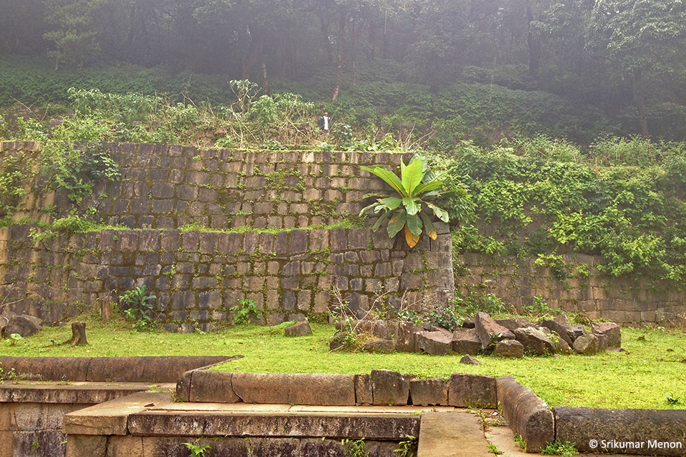
Visitors to the fort are advised to take a deviation from the town of Tirthahalli, where a road with ample signposts will take them to the make-shift parking lot to the southeast of the fort. The trail then leads over rocky patches and fields, skirting a marshy ground contained by a wall in typical Vijayanagara masonry, which must once have functioned as a moat. The best time to visit is just after the monsoon, in September or so. The fields are then lush green with paddy and the fortifications are festooned with forest vegetation trying to reclaim lost territory. The pathway leads up through gateways set into three lines of fortifications, each flanked by guard rooms.

The fortifications at Kavaledurga festooned with monsoon vegetation

One of the gateways in the fortifications, flanked by the remains of guard rooms
The first building that one encounters immediately after the gateways is the Shikhareshwara Temple. This temple, in typical Keladi Nayaka idiom of construction with merlon-like projections over its roof is set inside a walled compound approached through a colonnaded entry preceded by two free-standing columns on platforms. Opposite the Shikhareshwara Temple is a little rounded outcrop of rock, at whose summit is located a small Lakshminarayana shrine. The view from here, of the rolling hills stretching away to the horizon and the forest beyond the clearing with the temple, is stupendous.

A view of the Shikhareshwara Temple at Kavaledurga
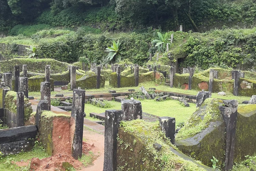
The trail leads on beyond the temples through yet another gateway into a clearing hewn out of the hillside, with massive retaining walls on two sides. Here one finds the remains of an extensive palace, of which only the plinth and the toppled columns survive now. Preserved among the remains of the palace is a firewood stove made from a single piece of stone and a stone toilet. A T-shaped tank with steps leading down to the water is located behind the palace.
The massive retaining walls, built in Vijayanagara style masonry, near the palace, with a part of the stepped tank in the foreground
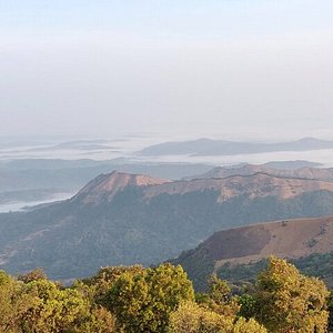
The path steepens now, even resorting to steps in patches, till it leads to a picturesque gateway set cunningly into the inner fortification wall. From here pathways lead to parts of the outer fortifications, beyond which stretch breath-taking views in every direction, with the waters of the Varahi Dam clearly visible at most times of the year. The view inwards towards the fort is equally rewarding, with the vista of the Lakshminarayana shrine set against endlessly rolling forests.

A gateway set into one of the lines of fortifications
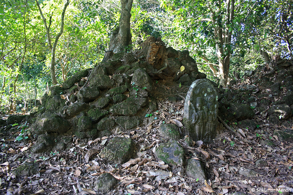
There is one more shrine near the outer fortifications perched atop a huge boulder. Ruins of a structure, maybe an armoury, lie nearby – a rectangular structure with stone masonry walls.

View towards the inner part of the fort from the outermost line of fortifications; the outcrop with the Lakshminarayana shrine is clearly visible
Kavaledurga, also known as Bhuvanagiri Durga, was a reliable forest stronghold for the Nayakas to fall back upon during times of duress. In 1677, the forces of Bijapur attacked and captured Bidanur after the death of the King Somashekhara Nayaka. His widow, the Queen Chennamma retreated to Bhuvanagiri Fort to recoup and she successfully won back Bidanur later. However, Chennamma’s finest hour was when she faced the wrath of the Mughal army under Aurangazeb’s general Jaan Nisar Khan following her granting safe passage for the Maratha Prince Rajaram through her dominions. The Mughals laid siege to Kavaledurga for months, but the tricky terrain and torrential monsoon rains of Malnad aided the guerrilla warfare tactics of the Nayaka army, who held off the enemy successfully. By then, Rajaram had reached the fortress at Gingee safely and the wearied Mughals sought a truce with this small kingdom in Malnad of Karnataka!

The view from near the outer fortifications
Today, centuries after those dramatic events, it is easy to empathise with the Mughal soldiers, for whom the dense jungles and the ferocious monsoons must have equally intimidating as the Nayaka army. As one bids good bye to Kavaledurga, one cannot but admire those ancient planners and builders who conjured up this impregnable fortress in the wilderness.

Srikumar Menon
Dr. Srikumar M Menon is an architect with a keen interest in the ancient history of the subcontinent. Passionate about the outdoors, he finds excuses of sufficiently academic nature to spend time in the wilderness, searching for traces of ancient humans. A recipient of the DS Achyutha Rao Fellowship (2007) for research on megalithic monuments and the Homi Bhabha Fellowship (2012-14) to study ‘Ancient Landscapes of South India’, he is currently working on the origins of monumental architecture in the Indian subcontinent. He is the author of two books.
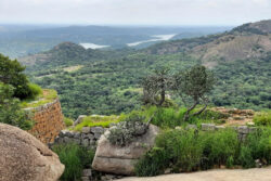
Savandurga Beyond the Trek
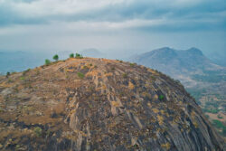
Handi Gundi Betta

A Landscape of Spiders
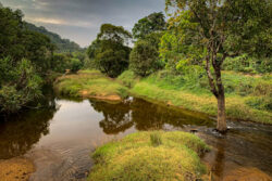
A Rainforest in Winter
Junglelodgesjlr.

Travel, Trek and Hike Forever
The blog is all about Must Visit Places in Karnataka and Best trekking places in Karnataka which I have visited.
- Trek and Hike
- Bigger Picture of Me
Sunday 29 June 2014
Kavaledurga fort, this page is obsolete. please visit -.

No comments:
Post a comment.
2018 Primetime Emmy & James Beard Award Winner
R&K Insider
Join our newsletter to get exclusives on where our correspondents travel, what they eat, where they stay. Free to sign up.
A History of Moscow in 13 Dishes
Featured city guides.
Fort Russell Neighborhood Historic District
Moscow city , latah county , id, home | whats new | site index | contact | search.
- Post Office: Moscow
- Zip Code: 83843

Photo: Looking West down B Street in the Historic District, Moscow. The Historic District on the National Register of Historic Places in 1980. Photographed by User:Davidlharlan (own work), 2012, [cc-3.0 ], via Wikimedia Commons, accessed March, 2023.
Original nomination [1]
The Fort Russell Historic District consists of 116 structures in nine square blocks, and fractions of twelve contiguous blocks, in the hilly northwest section of Moscow, Idaho. The district is almost totally residential in use. Only three buildings near the perimeter stand as exceptions: a school and two church buildings, one still used for worship and the other in service as a Senior Citizen's Club. These uses reflect the ambience of the neighborhood and its environs; it is an old residential area, its southeast corner within a few blocks of Main Street, ringed with service institutions: three more school buildings, four more churches, a Carnegie Library, the Post Office and Courthouse, and a city park are within a few blocks of the district. There are no commercial intrusions within it.
The district is strongly homogeneous not only in use but in style, scale, and, as it were, texture. The houses are predominantly from the late Victorian to early twentieth century periods. Fine examples of Queen Anne , Eastlake , Gothic Revival , Colonial Revival , Classic Box and Bungalow appear. In most of these styles, examples occur on both the "mansion" and the cottage scale. Not unexpectedly, this is especially true of the Bungalow style. The pattern prevalent in many turn-of-the century neighborhoods—whereby large homes are built on the corners of blocks, which later fill in with more modest dwellingss—holds true for the Fort Russell neighborhood. But while structures in the district range from small to grand, none exceed two- and-a-half stories, and most are one or two. Finally, the homogeneous streetscapes of residential, structures built largely from 1880 to 1920 and in related styles and scales are knit together by the texture of building material—mostly frame and brick&m dash;and by the texture of the rows of mature deciduous trees which distinguish the neighborhood and contribute much to its character.
The significance of the Fort Russell neighborhood District is both architectural and historic. It is manifestly significant for the rich display of early residential architecture it provides in a town of under 20,000 residents. It is significant as well for the historical connections between the houses and many of the people who built the town: the early entrepreneurs and professionals whose commodious homes expressed their positions of leadership in the community, and the more anonymous citizens whose neat cottages and bungalows grew up between the big houses—indeed, were sometimes built by the owners of them—a generation or two later.
The architectural interest of the district is immediately apparent to the eye. As specified in Section Seven, a neighborhood larger than the area which could reasonably be nominated as an historic district is generally continuous with it, and contains individual structures of substantial significance. It is noteworthy that five National Register properties the Cornwall house, the McConnell mansion, the Carnegie Library, the Methodist church and the Federal Building are located in the less architecturally cohesive but still handsome blocks to the south and west of the district. Moscow's Main Street, which contains a high percentage of early buildings, is only a few blocks further west. Thus perhaps a fifth of the area of this small city a town devoted primarily to servicing the wheatlands round about and the University of Idaho on the west side of town turns out to be of unusual architectural calibre. The Fort Russell district is the most architecturally cohesive core of this generally rewarding area.
Additional nomination [2]
Like Moscow's downtown, the Fort Russell neighborhood began developing during the last few decades of the nineteenth century, with the earliest dwelling dating to 1875 according to City of Moscow GIS property data. A total of 59 of the 243 total sites, nearly one full quarter (24%) within the district's expanded boundaries date prior to 1900, with construction and commerce slowing nationally during the mid-to-late 1890s as a result of the national financial crash that hit in 1893. Once construction began again, around the turn of the century, the neighborhood experienced a major boom with approximately 13% dating to the single decade between 1900 and 1910 at which time Moscow was growing rapidly as a regional commercial center. Approximately 18% of the buildings within the expanded district were then built between 1911 and 1920 as the city continued to grow steadily, another 14% between 1921 and 1930, and finally 20% going up between 1931 and 1940 indicating that residential growth continued at a higher rate than commercial growth during the Great Depression years of the 1930s during which only three commercial structures were built in the downtown district. The remaining 11% is made up of 26 post-1940 dwellings scattered throughout the neighborhood.
The Fort Russell Neighborhood Historic District represents a "rich display of early residential architecture ... significant as well for the historical connections between the houses and many of the people who built the town." It is associated with events, including community planning and development, education, entertainment and recreation, and religion. The District is an embodiment of the architecture and landscape architecture during the period of significance. The neighborhood retains a strong historical character and continues to represent its period as an intact historic district within the city of Moscow. Notwithstanding the presence of some modern buildings the district today retains integrity of location, design, setting, feeling, and association, and though some changes have been made over time to individual dwellings, overall integrity of workmanship and materials is present.
The expanded period of significance for the district begins in 1875, the earliest recorded construction date for any resources within the district boundaries, and extends through to 1940. The district exists as an early residential neighborhood with strong ties to the city's earliest pioneers and businessmen who were responsible for settling, establishing and growing the city and its economy. Post-1940 buildings are scattered in relatively small numbers within the proposed boundaries (accounting for just 11% of buildings within the expanded boundaries). Though modern construction begins to represent a different character moving beyond the period of significance, the presence of these buildings does not detract from the district's strong character and identity as a significant neighborhood reflecting Moscow's early growth.
In the area of architecture, the Fort Russell neighborhood is significant for its residential, educational, and religious buildings and its overall built character, which correspond to the first several decades of the city's growth and development. Both the high-style architecture of the late-nineteenth and early-twentieth centuries, including Victorian styles such as Queen Anne, as well as the more modest, accessible architecture of the 1920s and 1930s, such as Bungalows and English Cottage or Tudor Revivals, are found within the Fort Russell neighborhood. Though the architecture within the district varies resulting in an eclectic collection of buildings, the architectural forms and styles within the neighborhood are directly representative of national architectural trends for each decade during the period of significance, as well as representing the economic, social, and demographic patterns of city of Moscow itself.
The Fort Russell neighborhood's significance in the area of community planning and development is similar to what has been outlined for architecture, following both national and local trends related to economics and community development. The various additions within the district were platted during the city's earliest days, being laid out generally in a grid pattern with spacious lots intended to serve as an escape from the city's bustling town center. Over time, many of the lots were subdivided and filled in with smaller, more modest dwellings on smaller lots during the 1920s and 1930s accommodating the city's growing middle-class population while continuing to support the entrepreneurs that helped build it up originally. The planning and development evident within the Fort Russell neighborhood is also reflective of its central location, containing not only residential development but also schools, churches, and a major city park, all woven in to accommodate the needs of this diverse neighborhood as well as the needs of the city's general population who could access this area easily since it lies within walking distance to the city center.
Entertainment and recreation, and landscape architecture are related themes within the Fort Russell neighborhood, being represented by the planning and development throughout the neighborhood as well as by East City Park, which is situated in the southeast corner of the expanded district boundaries. This park was laid out in its original location and form during the city's earliest days—being reflected on the earliest city maps and Sanborn maps. The presence of the park reflects early intentions at providing recreation and embracing formal landscape architecture, by positioning the park within a reasonable distance of the city center so that it was accessible, yet removing it far enough from the central business district to ensure a relaxing, enjoyable environment within the park. Parks established around the turn of the twentieth century were intended to provide a rural- or countryside-style escape for city dwellers who were often unable to interact with the natural environment in any other way. Landscape architecture is additionally present within the neighborhood through the generally consistent grid pattern, setbacks, tree-lined properties, and landscaped residential yards found throughout.
In the areas of education and religion, the Fort Russell neighborhood is significant for containing a number of these buildings. The expanded district boundaries contain two schools, John Russell Elementary built in 1928 replacing an older school on the same site, and the old Moscow High School, built in 1912, as well as a 1906 Carnegie Library. Several churches are also found within the expanded boundaries, including Methodist, Catholic, Unitarian, Episcopal churches dating between 1900 and 1930; one contemporary church is also found within the district. The presence of a variety of educational and religious buildings further represent the fact that it was clearly intended to support not only the economically and socially diverse population living within the neighborhood, but also those who had easy access to the neighborhood due to its central location and its proximity to the city center. That these buildings were welcomed into this neighborhood also reflected the early importance of education and religion within the city's social structure.
- Adapted from: Patricia Wright, Architectural Historian, Idaho State Historical Society, Fort Russell Neighborhood Historic District, mp,ination document, 1980, National Park Service, National Register of Historic Places, Washington, D.C.
- Adapted from: Annie Doyon, MHP; Kathryn Burk-Hise, MSHP; Kathryne M. Joseph, MSHP, A. D. Preservation, Fort Russell Neighborhood Historic District (Boundary Increase), no,imation document, 2015, National Park Service, National Register of Historic Places, Washington, D.C.
Street Names A Street East • Adams Street North • B Street East • C Street East • D Street East • First Street East • Howard Street North • Jefferson Street North • Lincoln Street East • Polk Street North • Second Street East • Van Buren Street North • Van Buren Street South
Home | Whats New | Site Index | Contact Privacy | Disclaimer
Copyright © 1997-2024, the gombach group.
Find a bike shop near you | Trek Retailers
IMAGES
VIDEO
COMMENTS
Kavaledurga is a fort resting on the top of a hill amidst a dense forest and it requires a trek of at least 5 km to reach the summit. A spectacular combination of history and natural beauty, several shrines to Virupaksha, Vijaya Vittala, Veerabhadra, Mallara and Bhuvaneshwari are housed in the fort. Besides the ruins and an old palace, a mosque ...
A total of 3km is the trek distance both ways, and will take at least 2 hours' time if one is inclined to spend time to enjoy serenity and construction. At the fag end of the first 3 layers of the fort are two temples, of which a smaller one lies on a hillock.
Here are the details of Kavaledurga fort trek that all travellers or tourists can undertake and it is located near Thirthahalli town, Shimoga, Karnataka. +91 9916943398 / 8073465622. Search for: Home; About Us; Tours. ... Distance From Bangalore: 365 Km. Also, read: Hidlumane Falls Trek.
Kavaledurga is ancient hill fort situated near Shimoga in Karnataka that is perched at a height of 1541 metres. Although in ruins right now, the hill fort is still considered to be one of the most scenic and enchanting places in the state. Engulfed in greenery, the fort is surrounded by the majestic Western Ghats. ... Trek to the Kavaledurga Fort .
Though Google shows opening time as 8-30 am, you can reach the place by 7-30 am and start trekking. It is about 3kms trek and will take about 1 to 1.30 hours to reach the top. You can witness beautiful views of Mani dam from the top of the fort.
Temples at Kavaledurga Fort. There were originally 15 temples in the fort, but only three remain: Lakshmi Narayan Temple, Kashi Vishwanatha Temple, and Shikareshwara Temple. The Lakshmi Narayan Temple is located at the top of the hill. It is accessible via a flight of stairs and a tricky trek over a short distance that leads to the most ...
Kavaledurga, also called Bhuvanagiri, was a stronghold of the Nayakas of Keladi, who were the feudatories under the Vijayaanagara rulers and later became independent after the fall of the Vijayanagara kingdom . Venkatappa Nayaka (1582-1629) fortified the place here. Built a palace and made it an Agrahara with a Mahattina Matha. A Sringeri Matha.
I am talking about the 9th century Kavaledurga Fort, a multi level fort with strong fortifications, palaces, temples and that makes for a fabulous monsoon trekking destination in the Uttara Kannada region of Karnataka. ... but they will be a bit far away from Kavaledurga Fort. Things required for this trek: 1) A good pair of walking shoes or ...
25 January 2018. In the Western Ghats near Karnataka, at a prodigious altitude of 1,541 meters, lies the majestic Kavaledurga Fort, a truly beautiful landscape of mountains, forest land and rivers. The best way to explore this scenic environment is via an uphill trek, which isn't an easy one, but the gorgeous views and abundant natural beauty ...
Kavaledurga fort trek; Monsoon in Agumbe. Kavaledurga fort is a hill fort near to Agumbe, which is the wettest place in South India. When I visited Agumbe, the monsoon was at its best in the subcontinent. What else is the best time to visit such a place. We had to cancel our journey initially due to the landslides in the ghat road to Agumbe.
Kavaledurga Fort: The main attraction of Kavaledurga is its hilltop fort. The fort offers breathtaking panoramic views of the surrounding valleys, forests, and mountains. ... The trek to the fort itself is an adventurous experience, with a trail that winds through dense forests and rocky paths. The captivating natural beauty, including ...
KAVALEDURGA FORT TREK - KARNATAKA'S BEST KEPT SECRET | Places to visit in ShivamoggaWe visited the beautiful Kavaledurga fort in Shivamogga district on our ...
Kavaledurga Fort is one of the most majestic forts in the Western Ghats near Karnataka. It is located at a height of 1,541 meters above sea level. Built around the 9th century AD, this fort is a slice of forgotten history in the midst of the Western Ghats. In the Shimoga district of Karnataka, approximately 11 miles from the town of ...
Kavaledurga Fort - the marvellous architecture. The Kavaledurga fort was originally built in the 9 th century AD. The fort is a marvellous structure that includes complex defences and arrangements for rain water harvesting. The fort walls built of granite blocks range from 30 to 40 ft in height. There are watch towers is strategic places.
Google map distance to reach Kavaledurga Fort from Thirthahalli : 19 Kms. Best Time to do Kavaledurga Fort Trek. The trek can be done blissfully during the monsoon months of June till September. Enroute to the fort on the trekking path is an ancient temple that happens to open once in a year. The trek to reach the Kavaledurga Fort offers a ...
Before embarking on the trek to Kavaledurga Fort, ensure you wear comfortable footwear and carry sufficient water and snacks. It's also advisable to start early in the morning to avoid the heat and maximize your exploration. ... Thirthahalli - Explore the charming town of Thirthahalli, located just a short distance from Kavaledurga Fort ...
Kavaledurga: the Sentinel Fort. August 15, 2017. It was embarrassing, but we could not find the fort we had come to visit! Golden fields of ripening grain skirted the foot of a thickly forested low hill, which rose gently at first and then steeply upwards. A small placid lake was hemmed in between the fields.
This video is the ultimate guide to trekking Kavaledurga Fort and hoisting the Indian flag. From packing the right supplies to reaching the summit, this vide...
Let me come to KavaleDurga fort. The day I visited the fort, I did not find anyone else in my entire trek and it was totally abandoned place that day. ... Not worth a trek after travelling from long distance because you have better places nearby and I would suggest visit those rather than this place. However I was studying in Manipal when I ...
Or at the bottom of Tverskaya right opposite Kremlin entrance, stop in at Grand Cafe Dr Zhivago for a taste of Imperial Russian food and decor.. Take a walk around the Kremlin and Red Square, perhaps visit Lenin's Tomb. Then, duck into GUM, Moscow's department store from the 1800s.Wander through the legendary food hall, Gastronome No. 1. These days, it may stock fine food imports from all ...
The Fort Russell Historic District consists of 116 structures in nine square blocks, and fractions of twelve contiguous blocks, in the hilly northwest section of Moscow, Idaho. The district is almost totally residential in use. Only three buildings near the perimeter stand as exceptions: a school and two church buildings, one still used for ...
Showing 12 of 39 results. Back. ⌖ Use My Location. Store Locator by Locally.
The existing Fort Russell Historic District was first established as a historic district in 1980 - 35 years ago - and currently contains 116 properties. Properties are required to be at least 50 years of age to be declared historic, so many of the houses built in the 1930's were not included in the Fort Russell Historic District. ...