
Extended Tours
Tour calendar.
- Client Login

Port Macquarie Getaway
14th October 2024 (7 Days)
Port Macquarie region covers over 3,600 klms of diverse coastal and hinterland goodness.
Full itinerary out now!
Tour Highlights :
- Summerland Farm (macadamia & avocado farm)
- Carobana Carob Confectionary Factory
- Mary Boulton's Pioneer Cottage
- Camel Beach Safari
- 4 nights stayput in Port Macquarie
- Hastings River Cruise
- Bago Maze & Winery
- Artisan Famer
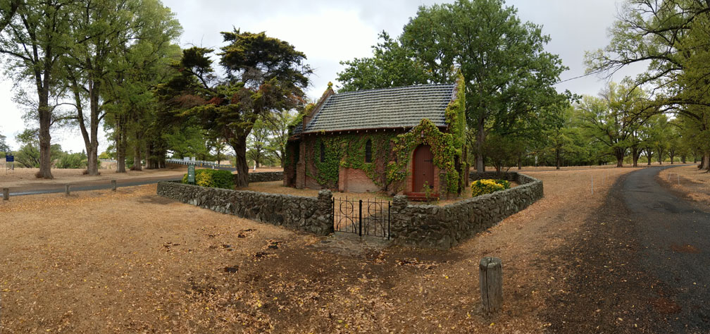
- Gostwyck Chapel
- + much more to see and do
Secure your seat now as there are limited numbers on this great tour.
Book your tour now!
Hunter Valley Tours

Local Day Trips & Special Occasions
New England Explorer
Fully Customised Private Tours

Group Transport
Introducing your hosts .
Ian & Nadia, locals on the Mid North Coast since 1988.
With a love of exploring new areas and sharing them, by providing a family oriented Private Tour service. Travelling in late model vehicles for your safety and comfort.
Based in Port Macquarie, offering day and multi day tours to many areas including Mid North Coast, Hunter Valley and New England regions.
Offering a fully licensed & insured tour service. Vehicles have GPS tracking and communication devices for added peace of mind.
Indulge in your dream getaway, experience the luxury of your very own Private Tour.
Gift Vouchers available
Why tour with Indulgence?
- Private tours
- Avoid crowds
- Family oriented
- Flexible and adaptable to suit your needs
- Go where large groups and coaches can’t access
- Easy fun going driver and guides
- Safety and comfort in late model vehicles
- More time at venues as not waiting on others and loading
- Take the trip you want, the way you want
- Pick up & drop off from home or accommodation
- 100% custom made around your interests, needs and budget
- Great value for money
- Parks Eco Pass licensed operator
- English & Italian speaking host
- First hand and unique info
- Great contacts for add-ons
- No hidden fees or surprises
- Fully packaged
- Locally owned and operated
Client Reviews


"WHEREVER YOU GO BRING YOUR OWN SUNSHINE ."
Anthony J. D'Angelo

Port Macquarie Coastline - 1 Hour
Helmets on! Ready? Here we go!
Slap on some sun screen and get ready for your exhilarating Port Macquarie Coastal Experience! Do you know there are a whopping 17 beaches in Greater Port Macquarie? If you're lucky, you might spot some magnificent whales or playful dolphins.
This Port Macquarie Coastal Trike Tour is about 60 minutes.
Starting at Settlement Point Reserve, we travel along Settlement Point Road then into town past the Marina, loop into Town Green, then onto Gaol Point lookout. Interestingly, Port Macquarie was once a settlement to provide secondary punishment for convicts who had re-offended in the colony of New South Wales. We will stop here to take in the best views in Port Macquarie viewing the mouth of the Hastings River, north to Point Plomer and around to Town Beach. This is also a great spot for whale watching and for photo opportunities.
Travel along the coastline, past Oxley Beach, down along Flynns Beach, then down Kenny Drive to Nobbys Beach. From Nobbys, we head to Shelley Beach through the Sea Acres rainforest canopy, then onto Lighthouse Beach to view the lighthouse and the coastline south to Lake Cathie. We then return to town along Pacific Drive giving another perspective of the coastline as we head north.
Price: $160 per tour regardless if it is for one or two persons.
Children must be above 8 years of age.
What to Bring?
We'll provide you with safety helmets, jackets and headsets. You will be asked your size when booking this tour. It is always good to put on some sun screen. Don't forget your sunnies (sunglasses) and camera!

1 HOUR PORT MACQUARIE COASTLINE TRIKE TOUR
Port Macquarie's best beaches

Holiday Coast Tours
Bus & coach charter & tours, holiday coast tours opening hours in port macquarie.
- Attract more customers by adding more content such as opening hours, logo and more
- Remove your competitors from this page
Products and Services
Air Conditioned, Australian Owned, Interstate, Intrastate, Local, Locally Operated, Locally Owned, Long Distance, Owner Operated, Regional, Seat Belts, Toilet Equipped, TVs, VCRs/DVDs
Catering To
Coaches, Schools, Seniors, Sporting Venues, Theme Parks, Wine Regions
Adventure, Commercial, Concerts, Day Tours, Day Tours, Dinner, Extended Tours, Extended Tours, Golf, Individuals, Private, School Camps, Short Tours, Shows
Bus & Coach Charter & Tours
School Supplies
Motorcycle Tours & Hire
Advanced & Defensive Driving School
Wedding Cars
Plumbers in Port Macquarie
Electricians in Port Macquarie
Lawyers in Port Macquarie
Pest Control in Port Macquarie
Mechanics in Port Macquarie
Locksmiths in Port Macquarie
Concreters in Port Macquarie
Fencing Contractors in Port Macquarie
Builders in Port Macquarie
Accountants in Port Macquarie
- About Yellow Pages
- Order or cancel your book
- Terms of use
- Get a free listing
- Digital marketing solutions
- Business hub
- myYellow login
- What’s On
- Entertainment
- Health & Fitness
For Bus & Coach Charter & Tours check out Port Bus. You can also find more Port Macquarie area Bus & Coach Charter & Tours and Transportation Services based listings here in the Port Now directory. If this is your business simply click or tap on the Claim Listing button above.

We have over 5,000 Port Macquarie businesses listed in our Port Pages Directory. Search for yours and CLAIM IT today. If you don't see your listing you can add it for FREE.
What's On - Upcoming Events
Port Now is your local news, entertainment and lifestyle website. We provide you with content showcasing the best Port Macquarie has to offer. We cover activities, landmarks, events, eating, drinking, night life, health and fitness.
Contact us: [email protected]
© Copyright - Port Now®
- Help Centre
- Terms Of Use
- Privacy Policy
Port Macquarie | Wauchope | Camden Haven | Hinterland
All Bus & Coach Hire
Sort options.

Port Bus Charters, Tours and Rentals

Indulgence Tours
- Port Macquarie
Sorry, no records were found. Please adjust your search criteria and try again.
Sorry, unable to load the Maps API.
Greater Port Macquarie Tourism Association (GPMTA)
Greater Port Macquarie Tourism Association (GMPTA) represents the interest of members to continue to develop and grow Greater Port Macquarie as a sustainable, major tourism destination through strategic planning, partnerships and effective lobbying to ensure the provision of quality visitor products and services.
Contact Information
- 0418 837 683
- [email protected]
- P.O. Box 557, Port Macquarie, NSW 2444

Share ×

Scan the QR code and open PeakVisor on your phone
❤ Wishlist ×
See all region register, peakvisor app, khanty-mansiysk autonomous okrug – ugra.
Welcome to the land of sheer silent whiteness. Its vast expanses are filled with fresh Arctic air, howling winds, and the spirit of true adventure. Come with us to the lands of the ancient Khanty and Mansi tribes that survived in this harsh climate of the Nether-Polar Urals . See the mountains that defy any logical or geological reason for their existence. Experience the wonders of this sparsely populated land where you can hardly see a human trace. Welcome to Yugra!
Flora & Fauna
Water resources, landmarks and tourism, major mountains, mount narodnaya, mount zaschita, mount neroyka, the pyramid mountain, samarovskaya mountain, ski and sports facilities, protected sites, reserves, national and natural parks, rivers and lakes, major cities, khanty-mansiysk.
The Khanty-Mansiysk Autonomous Area – Yugra (KhMAO) is located in the central part of the West Siberian Plain, stretching from west to east from the Ural Range to the Ob-Yenisei Watershed. The vast areas of this plain, as well as the Lower Priob region, are considered one of the most recently inhabited areas.

The Khanty-Mansiysk Autonomous Area (KhMAO) was established in 1930. Its name comes from two main northern indigenous peoples – the Khanty and the Mansi. From 1944 it was legally part of the Tyumen Region , but in 1993 the Area received autonomy and became a full-fledged territorial entity of the Russian Federation. It is a part of the Urals Federal District. The administrative centre is the city of Khanty-Mansiysk , whereas the largest city is Surgut. The word Yugra was introduced to the name of the Khanty-Mansiysk Autonomous Area in 2003 to pay tribute to the old name used by the locals to call the territories lying beyond the North Urals.
The KhMAO borders the Komi Republic in the north-west, the Yamalo-Nenets Autonomous District in the north, the Krasnoyarsk Area and the Tomsk Region in the east and south-east, the Tyumen Region in the south and the Sverdlovsk Region in the south-west.
The area of the territory is 534,801 sq.km, the length from north to south is 800 km, from west to east is 1400 km. The population of this huge territory is 1,674,676 people as of 2020, which is the same amount as people living in Barcelona or Munich.

The main part of the territory is a huge, poorly dissected plain where absolute elevation marks rarely exceed 200 meters above sea level. The western part of the KhMAO territory is characterized by low and middle mountainous terrains with some Alpine relief featured in the Subpolar Urals. Here are ridges and spurs of the mountain system of the North Urals and the Subpolar Urals. The maximum absolute elevations are on the border with the Komi Republic . Mount Narodnaya (1,895m) is the highest peak.
More than 800 species of higher plants grow in the Khanty-Mansi Autonomous Area . Almost the entire territory is covered by taiga forests that occupy about 52% of the area. Spruce, fir, pine, cedar, larch, birch, alder grow here. In the northern parts of the area, the composition of the vegetation is greatly influenced by perennial permafrost. Light lichen grasslands which are used as deer pastures are widespread there. Tundra dominates in the mountainous and hilly areas. River floodplains and lowlands are characterized by meadow vegetation, the so-called water meadows. High floodplains of large rivers are mainly covered with woods that mainly feature willows, birches and aspens. Forests and swamps are rich in berries and various valuable plants, most of which are used in traditional indigenous medicine.

The animal world is typical for the Russian taiga zone. There are 369 species of vertebrates. Mammals are represented by 60 species (28 of them are commercial species). The most common and valuable of them are wild reindeer, elk, fox, sable, fox, squirrel, marten, ermine, Siberian weasel, polecat, mink, weasel, otter, hare and others. Wolverine and West Siberian river beaver are included in the Red Book of Russia.
There are 256 bird species in the region, including 206 sedentary and nesting species. Some rare bird species are listed in the Red Book. There are 42 species of fish in rivers and lakes. Of these, 19 species are commercial, among them are starlet sturgeon, lelema, muksun (whitefish), pelyad, chir, lake herring, wader, tugun, freshwater cod, pike, ide, roach, bream, fir, perch, ruff, golden and silver crucian carp, carp (carp is grown in the cooling ponds of the Surgutskaya and Nizhnevartovskaya hydroelectric plants). Sturgeon is listed in the Red Book. There is an abundance of mosquitoes and gnats in the area, the greatest activity of which is in the second half of summer.

Yugra can boast of over 2 thousand large and small rivers, the total length of which is 172,000 km. The main rivers are the Ob (3,650 km), the Irtysh (3,580 km). These are some of the largest rivers in Russia. Other significant rivers include the tributaries of the Ob (the Vakh, Agan, Tromyogan, Bolshoy Yugan, Lyamin, Pim, Bolshoy Salym, Nazym, Severnaya Sosva, Kazym rivers), the tributary of the Irtysh (the Konda River) and the Sogom River. Ten rivers are over 500 km long. All the Yugra rivers with the exception of the rivers in the Ural part of the region are characterized by rather slow currents, gentle slopes, some surge wave phenomena, spring and summer floods. The Ob River basin extends over a distance of 700-200 km from the mouths of its tributaries. Such abundance of water facilitates the appearance of floodplain swamps and seasonal lakes.
The region's swamps are predominantly of the upper and transitional type. Those water basins occupy about a third of the region. About 290,000 lakes with the area of more than 1 ha are surrounded by swamps and forests. The largest lakes are Tursuntsky Tuman, Levushinsky Tuman, Vandemtor and Trmemtor. The deepest lakes are Kintus (48 m) and Syrky Sor (42 m). However, most of the lakes (about 90%) are modest and quite small and have no surface runoff.
The area is rich in resources of fresh, mineral and thermal underground waters, which are still insignificantly used.

The climate is moderately continental. Winters are harsh, snowy and long, and summers are short and relatively warm. The territory is protected from the west by the Ural Mountains but its openness from the north has a significant impact on the climate formation because cold air masses from the Arctic freely penetrate the area. The flat character of the terrain with a large number of rivers, lakes and swamps also has its impact. Most of the precipitation falls during the warm seasons. But even with a small amount of precipitation, their evaporation is very low, which as a result contributes to the formation of the zone of excessive moisture throughout the Yugra. The snow cover is stable from late October to early May, its height varies from 50 to 80 cm. The region is characterized by a rapid change of weather conditions, especially in transitional seasons (autumn and spring), as well as during the day. Late spring and early autumn frosts are rather frequent and can happen even until mid-June. Average January temperatures range from -18ºC to -24ºC (0 F to -11 F) and can reach -60ºC to -62ºC (-76 F to -80 F) when the northern cold air masses break through. The average temperature in July, the warmest month of the year, ranges from +15ºC to +20ºC (+59 F to +68 F) and on very rare days can reach a maximum temperature of +36ºC (+97 F). The prevailing wind direction is north in summer and south in winter.
The weather in the mountains is quite changeable and cool even in summer. The best time to visit the region's mountains is between July and mid-August.
The Yugra of the Khanty-Mansi Autonomous Area has a huge natural resource potential. These are oil and gas deposits, forests, gold and iron ore deposits, as well as bauxites, copper, zinc, lead, niobium, tantalum, brown and hard coal deposits, rock crystal, quartz and piezo quartz, peat deposits, etc. The region has plenty of natural resources. In terms of natural gas reserves, the Yugra ranks second in the Russian Federation after the Yamalo-Nenets Autonomous District .
The industry is dominated by oil and gas production, power generation and processing industries, including woodworking except for pulp and paper production.

The Khanty-Mansi area has very developed tourism of all kinds. There is a modern infrastructure for cultural exploration as well as for active recreation.
Fans of sports and eco-friendly tourism will be able to conquer majestic mountains and raft down picturesque rivers, enjoy the beauty of nature in nature reserves and natural parks. The hills and mountains of this area open up endless opportunities for skiing and snowboarding.
The mountainous part of the Subpolar Urals located on the territory of the Khanty-Mansi Autonomous Area is very beautiful. The highest peaks of the Ural Mountains are situated here.
Being the highest point of the whole Urals, Mount Narodnaya (1,895 m), also known as Naroda and Poenurr and translated as People's Mountain is territorially situated in the Subpolar Urals, on the border of the Yugra Area and the Komi Republic . It is the highest point in European Russia outside the Caucasus. This leads to its large topographic prominence of 1,772 metres (5,814 ft).

The top of the mountain is half a kilometre from the border towards Yugra. As for the name of the mountain, scientists could not come to a common opinion for a long time, so there are two versions. According to one version, in the Soviet years, an expedition of pioneers gave the mountain a name in honour of the Soviet people - Narodnaya (the stress is on the second syllable). According to the other version, even before the arrival of the first Soviet tourists, the peak was named after the River Naroda (the stress is on the first syllable) flowing at the foot of the mountain. The Nenets peoples called the River Naroda Naro, which means a thicket or a dense forest, and the Mansi peoples called it Poengurr or Poen-urr, which translates as the top, or head. The maps used to refer to it as Mount Naroda or Mount Naroda-Iz. Nowadays, it appears everywhere as Narodnaya.
In the 1980s, someone set a bust of Lenin on the top of the mountain. Its remains can be found there to this day. There is one more symbolic relic there – some Orthodox believers erected a worship cross on top of Mount Narodnaya after a Procession of the Cross.
The slopes of the mountain are steeper in the north-east and south-west and there are many steep rocks on them. The south-eastern and northern parts of the mountain are more gentle but they are also covered with scree. Be vigilant and careful when climbing! On the slopes of the mountain, there are many not only boulders but also caverns filled with clear water as well as ice. There are glaciers and snowfields. From the north-eastern part of the mountain, you can observe Lake Blue near which tourists and travellers like to make bivouacs.

Mesmerizing with its beauty and inaccessibility, it attracts many tourists and fans of active recreation. This majestic mountain is quite remote from the settlements, so getting to it is not an easy task. The mountain is located in the Yugyd Va National Park , so it is necessary to register in advance and get a visit permit from the park administration. How to get to the park administration and get a permit, read the article on the Yugyd Va National Park .
Mountain Zaschita (1,808 m) is the second-highest peak in the Ural Mountains, after Mount Narodnaya . Mysteriously, the name of the mountain, which roughly translates as Defense or Protection Mount, does not correlate in any way with the Mansi names of the nearby mountains and rivers. The origin of the name is unknown. There are some speculations but we will consider just one of them. On the map of the Northern Urals which was made by the Hungarian researcher Reguli the closest peak to Mount Narodnaya was called gnetying olu. Its location coincides with that of the present-day Mount Zaschita . The name gnetying olu in the Mansi can be deciphered as a mountain on which there is some help from ice. The mountain is believed to protect deer grazing on glaciers from mosquitoes. So, early topographers called the mountain more briefly – Mount Defense. Indeed, the slopes of this mountain are covered with a lot of snow and glaciers (the Yugra, Naroda, Kosyu, Hobyu glaciers and others). And it is here that the Mansi shepherds bring their deer which can rest on glaciers and snow. Summarizing all the above, we can say that Zaschita Mount is to some extent protection for deer from mosquitoes. The very name Zaschita appeared on maps with the beginning of hiking tours in the Subpolar Urals.
Mount Neroyka (1,645 m) is 100 km from Neroyka village, the closest tourist base to this peak. In the 1950s, people who were engaged in quartz mining near the mountain worked and lived in this base. Later, a gravel road was built from the village of Saranpaul to the mountain for large-scale development of the quartz deposit. In recent years, the road has not been much used and is practically not cleaned from snow in winter. There has been a plant built 20 km down from the mountain for primary processing of quartz with the use of nanotechnologies. There is an annual big camping event near the mountain. It is organized by the Tourism Department of the Khanty-Mansi Autonomous Area. You can have a 1-hour helicopter ride to the mountain from the village of Saranpaul. Should you wish to fly from the city of Khanty-Mansiysk , be prepared to fly over the taiga for 2.5-3 hours.

Quite inquisitive tourists happened to discover, by a lucky chance, a Pyramid similar to that of Cheops but four times bigger. It is located on the territory of the Narodo-Ityinsky Ridge. The closest to the pyramid is the village of Saranpaul. The sizes of the found pyramid are as follows: the height is 774 m, in comparison to the Egyptian pyramid which is 147 m; the length of a lateral edge is 230 m whereas the Egyptian pyramid is 1 km. The pyramid is located precisely according to the cardinal directions, there is not a single degree deviation at that. The origin of the pyramid is unknown, scientists are still making assumptions. No traces of human activity were found near the pyramid. The only way to get here at this time is by helicopter.
Samarovskaya Mountain is another wonder that is baffling many people. It is dividing the city of Khanty-Mansiysk into northern and southern parts. Few now living residents know that in the old days the highest part of the modern city used to bear a plural name of the Samarovsky Mountains among which there were Mount Palenina, Komissarskaya, Miroslavskaya, Filinova, and Romanova. Originally, there was a village called Samarovo amidst these mountains. Until now, many issues bewilder both residents and scientists. How could a mountain form in the middle of the West Siberian Plain? What is inside it? Won't the weight of the buildings erected on the top of the mountain affect its height? The uniqueness of Samarovskaya Mountain is that it consists of numerous large stones, boulders, rocks that are absolutely foreign to this area. Scientists have not yet come to a consensus on the mountain’s origin.

The Yugra is very famous for its ski resorts, the main of which are:
- The Cedar Ravine ski resort (Surgut city, Naberezhny Ave. 39/1)
- Three Mountains (Trekhgorie) ski resort (30 km from Nizhnevartovsk, Ermakovsky settlement)
- Stone Cape (Kamenniy Mys) ski resort (near the city of Surgut)
- Pine Urman ski resort ( Khanty-Mansiysk , Sportivnaya Str., 24)
The far-away lands of the Yugra are the blessed sanctuaries for many animals as the area is rather hostile to a human There are reserves, natural parks, wildlife sanctuaries here that aim to protect the national treasures of the lands. Having visited these regions once, you would crave for coming back again and again to feel that unique sense of unity with nature, to forget about the urban fuss and and hustles whatsoever. The harsh but beautiful nature of this extraordinary area leaves an indelible trace in the soul of every person.

On the territory of the district there are 25 specially protected natural areas, the most famous of them are:
- The reserves are two: the Malaya Sosva Reserve and the Yugan Reserve, the latter was established in 1982 as the largest reserve of taiga landscapes. The purpose of the reserves was to study unobtrusively and carefully preserve the endemic flora and fauna without disturbing natural processes. Hunting and economic activities are prohibited here, which is important for the preservation of natural ecosystems.
- The natural parks are the Samarovsky Chugas Nature Park, the Siberian Sloping Hills (Uvaly), the Numto (also called Lake Numto), and the Kondinskie Lakes.
These reserves and natural parks offer tourists their own excursion programs to make visiting their territory much more enjoyable and educational.
The Samarovsky Chugas Nature Park is located in the center of Khanty-Mansiysk , on a small hill between the Ob and Irtysh rivers.
The territory of the Siberian Sloping Hills (Uvaly) natural park is 350 km away from the city of Khanty-Mansiysk . You can get there by helicopter or by plane. The office of the park is located at 7a Pionerskaya Street, Nizhnevartovsk.
The Kondinskie Lakes Natural Park is located 380 km from Khanty-Mansiysk . Half of the park is covered with swamps, but there is also a recreational area. There you can rest, swim, do some amateur fishing, picking berries (cowberries, cranberries) and mushrooms is permitted. There is only one independent walking route here, it runs for 3 km in the deep forest. It is a cool place for kids since the park is equipped with sports grounds, a pool and a small zoo where the kids can interact with brown bear cubs. What else, try the TaiPark, it is a rope course running at the height of 2.5 meters, having 15 stages, the full length is 125 meters. There is an opportunity to order water walking tours in the town of Sovetsky, which can be reached by train from Khanty-Mansiysk .

The Numto Nature Park is located almost in the center of the West Siberian Plain, in the Beloyarsk district of the Khanty-Mansi Autonomous Area, 300 km from the city of Surgut and 200 km from the town of Beloyarsk. It is located on the border of Yugra and Yamalo-Nenets Autonomous Area. The administration of the park is located at 2, Beloyarsky micro-district, 4a. The territory of the natural park is a treasure trove of archaeological and ethnocultural monuments. As of today, there have been discovered 20 architectural monuments, including fortified and not fortified settlements, places of worship abandoned by the peoples who lived here from the Stone Age to almost the present day. Researchers have also found 65 monuments of ethnic value, the main of which are worship objects, sacred places and cemeteries.
The Malaya Sosva Reserve includes several subordinated territories and sanctuaries, including Lake Ranghe-Tour. The reserve offers a 4-km walking guided route that gets the visitors introduced to the typical features and characteristics of flora and fauna of the region. The route is called Bear Trail and you can spot bears there (don’t come close though, we’ve already written how to behave if you meet a bear in the wild). Also, you will see the River Malaya Sosva, some marshes, ancient cultural monuments and other nice sights. Permission to visit the reserve can be obtained from the administration of the reserve at Lenina Str. 46, town Sovetskiy.
As to the Yugan Nature Reserve , it is inaccessible to common hikers who are afraid of flying since there are no roads to it. The only way to get there is taking a helicopter ride. You also must obtain a permit in the administration of the reserve, go accompanied by employees of the reserve, and only on special transport of the reserve (motorboat, snowmobile). The central manor of the Reserve and the administration are located in the village of Ugut. To get to this village, you should first go to the town of Surgut, then go to the town of Pyt-Yakh, and from it there is a road to the village of Ugut. It is about 100 km from Ugut to the southern border of the reserve i, and another 25 km to the nearest cordon. The administration works from Monday to Friday. You can request a permit via mail at [email protected] , order a guided tour at [email protected]

The Yugra lands are heaven for water sports aficionados. They can have some awesome fishing or go rafting along such rivers as: the river Naroda, the Deep Sabun, etc.
The Naroda River is 140 km long. It is the left tributary of the Manya River located in the Ob River basin. The river has its origin on the south-western slope of Mount Narodnaya . It is a mountain-taiga river with rapids, swifts, numerous rolls, which attracts interest among water tourists. However, it is usually not rafted very often.
The Deep Sabun River flows through the territory of the Siberian Sloping Hills Nature Park. The park has developed multi-day water routes. It is possible to raft along the river in summer and to go skiing along it in winter.
The Kondinskie Lakes are a system of lakes along the left bank of the Konda River. The largest lake is the Arantur, with pine forests on the northern side and sandy beaches well equipped for a nice relaxing me-time. The water heats up well in summer. The small river Okunevaya and the river Maly Akh flow into the lake. The Maly Akh comes in on the west side and connects lake Arantur with Lake Pon-Tour. This lake is the richest in fish, and there is also a parking lot for fishermen here. The streams connect Pon-Tour with small lakes Krugloe and Lopukhovoye. When you look at Lopukhovoe lake, you feel as if you have found yourself in a fabulous place: more than half of its surface is covered with white lilies, as well as yellow flowers of the water-beans. Then the river Big Akh, which flows into the river Konda, connects all the lakes into a single system. Along the river there are many archeological monuments such as forts and settlements which have paths to them. The southernmost lake of the park is Ranghe-Tour.

Yugra is not the easiest destination and not the most accessible, but the effort is well worth it. You should first get to the capital of Khanty-Mansiysk Autonomous Area – the city of Khanty-Mansiysk either by air or by train.
Khanty-Mansiysk is based on the premises of the former village Samarovo founded in 1582. It used to be the territory of the Khanty people and a pit stop for coachmen who rode their wagons across the country. The village was founded by Russian Count Samara, thus the name Samarovo. The modern city actually began to develop in 1930 because amidst the Siberian taiga there finally started to appear stone houses on the high bank of the Irtysh River. In 1940, the village was renamed into Khanty-Mansiysk by the name of the peoples living on this territory – the Khanty and the Mansi, and in 1950 it received the status of a town.

The city has several attractions. Mount Samarovskaya is probably the biggest natural and scientific wonder. It divides the city in two parts and causes many concerns for urban developers who always wonder whether this mountain can move making the buildings slide or even sink in.
Another beauty is the century-old cedar grove that is within the city limits. The grove is a part of the natural park Samarovsky Chugas. The word chugas in the language of the Khanty means a lonely hill in the low river floodplain.

The park is one of the main attractions of the city, it hosts an open-air ethnographic museum called the Torum Maa, a cultural and tourist complex called Archaeopark, a biathlon center. Kids and adults, nature lovers and fans of culture love this place dearly.
A memorial sign to Yugra's discoverers is installed on top of the Samarovsky Chugas. It is a tall stele pyramid divided into three portions. On the lower level, there is a restaurant, on the second level is a small museum, and on the third level there is an observation deck, 40 m above the ground, with a magnificent view of the Irtysh River and the river port. The pyramid is decorated by the bas-relief depicting the discoverers of the region, from the 16th-century Count Samara to the geologists of the 20th century.
Another trademark of Khanty-Mansiysk is the State Museum of Nature and Man. The museum hosts a gallery and a workshop of a famous artist G. Rayshev.
The city has a lot of small monuments generously spread around the city. There is the Khanty family resting on a camp, this monument is near the airport building. You can take a pic at the Golden Tambourine located at the intersection of Gagarin Street and Mira Street. Connoisseurs of culture should also visit the Sun – the Theatre of Ob-Ugrian Peoples, it is the world's first professional theatre of Khanty and Mansi peoples. And if you are travelling with kids, the Khanty-Mansiysk Puppet Theatre is a must-visit. In the period from May to October, you can take a boat ride to the confluence of two rivers – the Ob and the Irtysh. Yugra Service Co. operates such cruises, you can find more information locally at their address Tobolsk Trakt street 4, Khanty-Mansiysk .

Explore Khanty-Mansiysk Autonomous Okrug – Ugra with the PeakVisor 3D Map and identify its summits .
PeakVisor Hiking Maps
Be a superhero of outdoor navigation with state-of-the-art 3D maps and mountain identification in the palm of your hand!

- FIND REALTORS ®
- NEWS & INSIGHTS
10/140 Kennedy Drive, Port Macquarie, NSW 2444

Immaculate Shelly Beach Villa
Property details, indoor feature, floorplans and tours.

Contact Agent
Email enquiry to HEM Property - PORT MACQUARIE
Property ID : 145489984
Similar Properties
Price Guide $950,000 to $1,000,000
Incredible Coastal Home, Plus Studio Space
Big Home, Big Oppourtunities
Buyer Guide $880,000 - $920,000
Large Family Home With Self-Contained Flat
Surgut topographic map
Interactive map.
Click on the map to display elevation .
About this map

Name : Surgut topographic map, elevation, terrain.
Location : Surgut, Khanty-Mansiysk Autonomous Okrug – Ugra, Ural Federal District, 628400, Russia ( 61.22483 73.23552 61.35858 73.68910 )
Average elevation : 48 m
Minimum elevation : 23 m
Maximum elevation : 78 m
Surgut map – loading . . .
Khanty-mansiyskiy avtonomnyy okrug - yugra.
Name: Surgut
Latitude: 61°15'00"N
Longitude: 73°25'00"E
City: Surgut
Region: Surgut
Region: Khanty-Mansiysk Autonomous Okrug – Ugra
Region: Ural Federal District
Country: Russia
02 6583 3330
Charter a Bus

- Reclining Coach seats
- Air Conditioning
- DVD/PA; Tape/Radio/CD/DVD
- Large luggage capacity
- Electronic Destination
- Luggage Trailer Add-on
Department of Subsoil Use and Natural Resources of Ugra

Department of Subsoil Use and Natural Resources of the Khanty-Mansiysk Autonomous Okrug - Ugra (Depnedra and Natural Resources of Ugra) is the executive body of the Khanty-Mansiysk Autonomous Okrug - Ugra (hereinafter referred to as the Autonomous District) performing the functions of implementing the unified state policy and regulatory legal regulation, management of state property, provision of public services in the field of geological study, use and conservation of the subsoil, modernization of the oil and gas complex and rational use of hydrocarbons; forest and water relations, use, reproduction, protection of wildlife and their habitat, organization and functioning of specially protected natural areas of regional importance.

IMAGES
VIDEO
COMMENTS
Providing hassle free Bus Charters, Tours and Rentals in the Port Macquarie region.
Holiday Coast Tours in Port Macquarie is locally owned and operated by Henryk and Jayne Wesierski. We cater for Clubs, large groups and sports group tours.
Top Port Macquarie Bus Tours: See reviews and photos of Bus Tours in Port Macquarie, Australia on Tripadvisor.
Thursday 8 June 2023. Cost $80 per person. Depart the Port Macquarie Coach Terminal at 8:30am. We depart the Port Macquarie Coach Terminal at 8.30am and everything else is a mystery. Morning tea, lunch & visits are all included so sit back & enjoy the ride! COST: $80.00 per person includes air-conditioned coach travel, morning tea, lunch & visits.
Aug 27, 2024 - Find & Book the top-rated and best-reviewed tours in Port Macquarie for 2024. From prices and availability to reviews and photos, Tripadvisor has everything you need to create that perfect itinerary for your trip to Port Macquarie.
Holiday Coast Tours - Tour Schedule. Select and view Day Tours and Extended Tours. View our Tour Calendar and other Tour Information.
Port Macquarie Getaway - Discovery Coaches | Bus Tours Outback Tours Queensland. Port Macquarie Getaway. 14th October 2024 (7 Days) Cost:-. Adult: $2695 per person twin share. Single Traveller: $3320. Port Macquarie region covers over 3,600 klms of diverse coastal and hinterland goodness.
Port Bus is a family-owned and managed the business on the Mid North Coast of Australia. They offer a variety of Local Tours, Tours to outer Regions and Event Transport.
Based in Port Macquarie, offering day and multi day tours to many areas including Mid North Coast, Hunter Valley and New England regions. Offering a fully licensed & insured tour service. Vehicles have GPS tracking and communication devices for added peace of mind. Indulge in your dream getaway, experience the luxury of your very own Private ...
This Port Macquarie Coastal Trike Tour is about 60 minutes. Starting at Settlement Point Reserve, we travel along Settlement Point Road then into town past the Marina, loop into Town Green, then onto Gaol Point lookout. Interestingly, Port Macquarie was once a settlement to provide secondary punishment for convicts who had re-offended in the ...
Holiday Coast Tours Bus & Coach Charter & Tours - Port Macquarie, New South Wales, 2444, Business Owners - Is Holiday Coast Tours in Port Macquarie, NSW your business?
3 of the best Coach Charters & Bus Tours in Port Macquarie NSW! Read the 1+ reviews, find payment options, send enquiries and so much more on Localsearch.
One of the best and most popular markets on the mid north coast. With over 260 diverse and colourful stalls. 3rd Saturday of the Month. Pick Your Date.
Port Bus Charters, Tours & Rentals Pty Ltd, Sancrox, New South Wales, Australia. 2,040 likes · 45 talking about this · 8 were here. Charters and Tours for all groups sizes. Mini Bus Rentals: 12, 14,...
Port Bus Charters, Tours and Rentals provides local bus tours and bus charter services to a wide variety of events.
For Bus & Coach Charter & Tours check out Port Bus. You can also find more Port Macquarie area Bus & Coach Charter & Tours and Transportation Services based listings here in the Port Now directory.
Offering day and multi day tours to many areas including Port Macquarie - Hastings Area, Read more...
There is an opportunity to order water walking tours in the town of Sovetsky, which can be reached by train from Khanty-Mansiysk. The Numto Nature Park is located almost in the center of the West Siberian Plain, in the Beloyarsk district of the Khanty-Mansi Autonomous Area, 300 km from the city of Surgut and 200 km from the town of Beloyarsk.
10/140 Kennedy Drive, Port Macquarie, NSW 2444 House. This 2 bedrooms 1 bathroom House is for sale on realtor.com by HEM Property - PORT MACQUARIE.
Affordable self drive bus hire in Port Macquarie region Port Bus Charters, Tours and Rentals has a wide range of buses available for self drive. Our range of buses are capable of handling short trips through to interstate transfers.
Name: Surgut topographic map, elevation, terrain.. Location: Surgut, Khanty-Mansiysk Autonomous Okrug - Ugra, Ural Federal District, 628400, Russia (61.22483 73.23552 61.35858 73.68910)
Restaurants, hotels, bars, coffee, banks, gas stations, parking lots, groceries, post offices, hospitals and pharmacies, markets, shops, cafes, taxi and bus stations, landmarks and other places on the interactive online map of Surgut (Khanty-Mansiyskiy Avtonomnyy Okrug - Yugra / Russia).
Providing bus charter services in the Port Macquarie region.
Company:Department of Subsoil Use and Natural Resources of Ugra, Government of the Khanty-Mansiysk Autonomous Okrug - Ugra, Khanty-Mansiysk Autonomous Okrug, State, Oil industry, State and social structures, Russia, Ural Federal District of the Russian Federation, Khanty-Mansiysk