- Skip to primary navigation
- Skip to main content
- Skip to primary sidebar
- Skip to footer

Ultimate France
A Thrill-Seekers Guide
- Auron-Saint Etienne
- La Moulière
- Montgenèvre
- Riviera Borderlands
- Serre Chevalier
- Ubaye Valley
- Val d’Allos
- Alpe d’Huez
Tour du Mont Blanc
- Les Deux Alpes
- Val d’Isère
- Mountain Biking Basque Country
- Mountain Biking Northern Italy
- Finale Ligure
- Mountain Bike Hire
- Cycle Shops & Repairs
- Airport Transfers
- Campervan Hire
- Road Cycling
- French Alps
- South of France
- Cycling Holidays
- Arcachon-La Salie
- Biscarrosse
- Mimizan Plage
- Moliets Plage
- Saint-Jean-de-Luz
- Vieux Boucau
- Surf Shuttles
- Campervan Rental
- Basque Country Beaches
- Surf Webcams
- Quiksilver Pro France
- World Surfing Games
- Almanarre, Hyères
- Beauduc, Camargue
- Espiguette, Camargue
- Lac de Serre-Ponçon
- Le Jaï-Etang de Berre
- Leucate-La Franqui
- Saint-Laurent-du-Var
- Sète-Etang de Thau
- Montpellier
- Les Menuires
- Val Thorens
- Arêches-Beaufort
- Bourg-Saint-Maurice
- Les 2 Alpes
- Les Houches
- Val d’Isère
- Les 3 Vallées
- Vallée Blanche
- Heli-Skiing & Boarding
- Extreme Steep Skiing
- Chalet Accommodation
- 100% Snowboard
- Ski & Snowboard Holidays
- Ski & Snowboard Rental
- Off-Piste Guiding
- Last Minute Deals
Gorges du Verdon
- Climbing Guides
- Mountaineering
- Mountaineering Guides
- Canyoning Guides
- Aqua Trekking Guides
- Tour des Ecrins
- Tour du Mont Blanc – A Classic Long-Distance Walk in the Alps
Mont Blanc Ascent
- Hiking Guides
- Rafting Companies
- Tandem Kayaking
- Via Ferrata Guides
- Saint-André-les-Alpes
- Paragliding Schools
- Tandem Flights
- Aix-en-Provence
- Cévennes NP
- Gorges du Tarn
- The Luberon
- Massif de l’Esterel
- Mercantour NP
- Mont Ventoux
- The Vercors
- Mountain Bike Parks
- Ski Resorts
- Last Minute Ski Deals
- Ski & Snowboard Lessons
- Île d’Oléron
- La Rochelle
- Terres Noires Enduro
- CRANKWORX – Les Gets
- Megavalanche
- Pass’Portes du Soleil
- MTB Instructor Course
- Roc d’Azur
- Spadtribu – Ubaye Valley
- Natural Games
- La Grave Off-Piste Adventure
- Snow & Rock Backcountry Skiing
- Val d’Isère Photo Comp
- Waterproof Cycling Jackets
- Expedition Duffel Bags
- Backpacks under 30l
- Mountain Bike Helmets
- Snowboard Boots
- Snowboard Helmets
- Base Layers
- Waterproof Jackets
- Shimano CM-1000
- Lapierre X-Control
- Soft Roof Racks
- Wetsuit Buying Guide – Everything you need to know to choose the right wetsuit
The Tour des Ecrins (GR54) Multi-Day Trek
A long distance multi-day mountain trek in the largest and highest National park in the French Alps. With its stunning snow capped mountains and tumbling glaciers the Parc National des Ecrins and GR54 footpath offer an unrivalled mountain journey.

Tour des Ecrins Overview
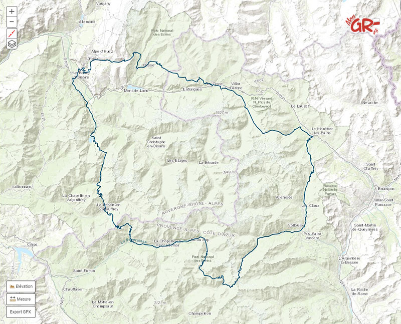
For breathtaking views of glacier lakes and a real sense of remoteness, take time out to hike the GR54, or the Tour des Ecrins. A classic circular trek, it covers 180 km and is one of the most challenging routes in Europe. Reasonably fit backpackers will comfortably complete this trek in the summer without the need for mountaineering skills or equipment in around 7-12 days.
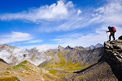
Renowned as one of France’s wildest GR treks, the highlights for us are the amazing views of the main peaks of the Ecrins Massif and Lac Lauvitel which blew our mind. High, steep and remote in places, it helps if you have a good head for heights and good scrambling ability, but this adds to the feeling of achievement at the end. The route tops out at 2735 m so shouldn’t cause problems for regular walkers.
The Walking
The Tour des Ecrins (GR54) has a reputation for being one of the most challenging multi-day mountain treks in the Alps. This circular 10+ day trek in the Ecrins National Park is over 180 km long, includes 12,800m of ascent and crosses 14 high cols. Although the trek is considered one of the toughest in the Alps, the nature of the paths and availability of numerous mountain refuges and valley gites means it can be undertaken by anyone of reasonable walking fitness, experience and enthusiasm. French Alps Trekking also offer a 6-day version which takes in the most remote southern section of the GR54.
The trek is usually started from near the town of Le Bourg-d’Oisans to the northwest of the park and follows a mountainous route around the Barre des Ecrins (the most southerly 4000 m peak in the Alps) as well as passing the spectacular peaks of La Meije (3983 m) and Mt Pelvoux (3946 m) and numerous other mountains over 3500 m. Main villages en route include La Grave, Vallouise and La Chapelle en Valgaudemar.
The steep sided valleys typical of the Ecrins are rich with wildlife, including chamois, ibex, golden eagles, griffon vultures and marmots. A wealth of plants and wild flowers and impressive physical geography will delight nature lovers on a daily basis.
Tour des Ecrins Trek Profile
Number of days walking: 10+ (or 6 day version along the southern section) Pace: Each day will involve up to 1000 m ascent, between 10-18 km walking and time of 6-9 hours, including stops for photos, rest and refreshment. Terrain: Good paths with some exposure and short sections of easy scrambling. Longest day: 18km Max altitude: The Pas de Cavale – 2735 m
Typical Tour des Ecrins Itinerary
Day 1: La Danchere or Venosc passing lac du Chambon and on to refuge des Clots (1520 m) Day 2: Refuge des Clots via the Plateau d’Emparis (2365 m), lac noir and lac lerie to Le Chazelet (1800 m) Day 3: Le Chazelet to Villar D’Arene, up to Col du Arsine (2451 m) and on to Monetier les Bains (1500 m) Day 4: Monetier to col de l’Eychauda (2425 m) and on to Vallouise. Day 5: Vallouise to Pas de Cavale (2735 m) and descent to refuge Pre de la Chaumette (1810 m) Day 6: Ascent to Col du Vallonpierre (2530m) and on to refuge du Clot Xavier Blanc (1700 m) Day 7: Pass through La Chapelle en Valgaudemar and up to Refuge des Souffles (1975 m) Day 8: over the Col de la Vaurze (2500 m) and descent to gite in Le Desert du Valjouffrey Day 9: Le Desert over la Cote Belle (2290 m) to Valsenestre. Day 10: Valsenestre via Col de la Muzelle (2613 m) and return to La Danchere
Tour des Ecrins Trekking Guides
Available to all fit and adventurous walkers, guided Tour des Ecrins treks run between June and September. The full tour takes approximately 10 days and you can expect to walk about 15 km per day with 1000 m+ vertical ascent each day. The cost generally includes guiding, accommodation in mountain huts and most meals.
Practical Information
What’s included.
All accommodation during the trek in mountain refuges and comfortable valley based gites. All breakfasts and evening meals.
What’s Not Included
Flights to France, travel to start point, travel Insurance, personal hill food/lunch for each day.
Fitness Level
This is a strenuous and high level trek with days covering over 15km distance with 1000+m ascents but is open to all fit and adventurous walkers.
This is a small group adult holiday. The group is usually between 4 and 6 like-minded people booking individually, in a couple or as friends together.
Accommodation
Accommodation on the trek is easy to find with plenty of choice of mountain refuges, valley hotels and gites, but be careful as these fill up quickly from mid-July through August and many are closed by October. Early September is perfect if you can manage it – the crowds disappear and the weather is ideal for walking. Wild camping is also an option but you can’t pitch near the refuges.
FAQ: Planning your GR54 Multi-Day Trek
The GR54, also known as the Tour of the Ecrins Massif, is a long-distance trekking route that encircles the stunning Ecrins National Park in the French Alps in southeastern France.
The entire GR54 loop is approximately 176 kilometers (109 miles) long. Depending on your fitness level and the number of stops you make along the way, the hike typically takes about 10 to 15 days to complete.
The best time to hike the GR54 is typically during the summer months, from late June to early September. This period offers the most favourable weather conditions and ensures that mountain huts and facilities are open.
No, you do not need a permit to hike the GR54. However, it’s a good idea to check in with the Ecrins tourist office for any specific regulations or updates on trail conditions before you start your hike.
The GR54 is considered a challenging trek due to its mountainous terrain and significant elevation changes. Hikers should have prior experience with multi-day hiking and be in good physical condition.
The hike up to the Col de l’Aup Martin , the highest point on the circuit, is high alpine trekking at its finest. And following the climb, the descent to the Pré de la Chaumette is steep and challenging.
Your packing list will differ whether you plan on staying in refuges or camping. For both scenarios, your gear list should include appropriate clothing for varying weather conditions, a comfortable and supportive backpack (approx 50 litres), sturdy hiking boots, rain gear, and a map of the trail. If you plan on camping, add a good-quality, lightweight tent, a sleeping bag, a stove, food supplies, and a headtorch.
Yes, there are several mountain huts, valley based gites and basic camping areas along the GR54, which offer accommodation and dining options. Reservations are strongly recommended during the high season.
The GR54 is a circular route and therefore has multiple access points, and the best one for you depends on your preferences and the direction you plan to hike. Some common starting points include the towns of Briançon, Bourg-d’Oisans, and La Grave. You can reach these towns by train or bus from major cities in France.
Yes, there are drinking water fountains in the small villages/accommodations en route. There are many streams, rivers, and natural water sources along the trail but to use these it’s essential to have a water purification system to ensure the water is safe to drink. Consider carrying a water filter or purification tablets.
In case of an emergency, you can contact the local emergency services by dialing 112. It’s also a good idea to carry a charged mobile phone with you, but remember that mobile reception can be unreliable in some remote areas.
While it’s helpful to know some basic French, especially for communication with locals and obtaining information, many people involved in the tourism industry in this region understand English, especially in popular hiking areas.
Pets are not allowed in the Ecrins National Park. However some sections on the GR54 trail are not in the Park so dogs can be walked on a lead, but in general it is not an option to take a dog on the GR54.
Wild camping is generally permitted from 7pm to 9am. Campfires are not allowed, but you can use a camping stove. There are a few areas where wild camping is not permitted, including around Lac de la Muzelle and Lac Lauvitel. In these areas you can only camp in designated areas. You can camp near refuges, but if you plan to eat at the refuge make sure you book ahead – they only have limited supplies.
Remember that the GR54 is a challenging and remote trek, so proper planning, physical preparation, and thorough research are essential for a safe and enjoyable experience. Always check for the latest information before setting out on your adventure.
You may also like...

Hiking South France

Hiking French Alps

Trekking Companies

For Business Owners
Add your business Rejoindre l'annuaire
Assoc. Atout France
Top mountain bike resorts, secure payments.

- Faire un don
- GR @ccess : créer et planifier son itinéraire sur un GR®
- Découvrir les itinéraires de Grande Randonnée GR®
- L'histoire des GR®
- Le balisage des itinéraires de randonnée
- Suricate : signaler un problème sur les sentiers
- Le GR® 2, le sentier de la Seine
- GR® 3, la Loire sauvage à pied
- GR® 4, de l’Atlantique à la Provence
- GR® 5, le sentier de l’Europe
- GR® 6, des Alpes à la Nouvelle Aquitaine
- GR® 9, du Jura au Var
- GR® 10, la grande traversée des Pyrénées
- GR® 20, à travers la montagne corse
- GR® 22, chemin vers le Mont-Saint-Michel
- GR® 34, le sentier des douaniers
GR® 54, tour de l'Oisans et des Ecrins
- GR® 65, le chemin de Compostelle via le Puy
- GR® 68, le tour du mont Lozère
- GR® 70, le chemin de Stevenson
- GR® 107, le chemin des Bonshommes
- GR® 145, la Via Francigena
- GR® 223, Littoral de la Normandie
- GR®340, le tour de Belle-Île-en-Mer
- GR® 400, le tour du volcan cantalien
- Le GR®509- La Grande Traversée du Jura
- Le GR®653, sur la voie d’Arles vers Compostelle
- GR® TMB, le Tour du Mont-Blanc
- GR® R1, tour du piton des Neiges
GR® 54, au coeur du Parc national des Ecrins
Tracé du GR ® 54 :
+ Cliquez sur la carte pour accéder au parcours du GR® 54
Descriptif du GR ® 54 :
Considéré comme l’un des GR ® les plus difficiles d’Europe, en raison notamment de son enneigement tardif, des pentes raides avec des schistes glissants, le GR ® 54 contourne le massif de l’Oisans et des Ecrins en une douzaine de jours.
Il passe au plein cœur du Parc national des Ecrins (départements de l’Isère et des Hautes-Alpes) dont le symbole est l’aigle royal et où l’on rencontre une flore rare : le sabot de Vénus, la joubarbe ainsi que de belles forêts de mélèzes.
Ce GR ® totalise une longueur d’environ 176 kilomètres avec un dénivelé positif de plus de 12 000 mètres pour la totalité du trajet. Il franchit une série de cols (l’Aup Martin – 2761 m, la Muzelle - 2 613 m) pour accéder à des vallées reculées comme la réserve naturelle de la Haute-Séveraisse en Valgaudemar. Situé en montagne, ce sentier n’est praticable qu’à partir de fin juin jusqu’à fin septembre.
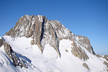
Particulièrement sportif, il est conseillé aux randonneurs aguerris même si certains tronçons (comme la vallée de Vallouise ou le plateau d’Emparis avec les lacs Noir et lac Lérié) sont plus faciles que d’autres, comme le col de l’Aup Martin ou de la Muzelle . Il convient également de planifier soigneusement ses étapes et de réserver à l’avance les refuges en se renseignant sur leurs dates d’ouverture.
+ d'infos sur le GR® 54 sur MonGR.fr

Faites votre recherche et appuyez sur entrée (ex : un mot "licence", une suite de mots ou une expression "licence+fédérale") Rechercher
Le GR54 : tour de l’Oisans et des Écrins en 8 / 9 jours
Vous rêvez d’une aventure inoubliable au cœur des Alpes ? Le GR54, également connu sous le nom de Tour de l’Oisans et des Écrins, est un sentier mythique qui vous offre une expérience de randonnée exceptionnelle.
Ayant récemment achevé cette incroyable aventure de plusieurs jours, je suis ravie de partager mon retour d’expérience et mes conseils pour les futurs marcheurs. Dans cet article, je partagerai des astuces précieuses pour vous préparer au mieux et profiter pleinement de ce magnifique trek.
Vous êtes donc au bon endroit si vous souhaitez faire le tour complet du GR54 pendant 8 ou 9 jours depuis Bourg d’Oisans.
Mes services de Travel Planner
Pour préparer votre GR®, rien de mieux que d’utiliser les nombreuses ressources sur la boutique en ligne de la FFRandonnée.
Votre achat contribue également à la maintenance des sentiers. La boutique propose le meilleur de la randonnée : topoguides , guides de randonnée, cartes IGN , accessoires , vêtements , produits siglés, produits partenaires innovants ou orientés développement durable, magazine Passion Rando (abonnement, hors-série), RandoPass ( assurance ).
Ceci est un lien affilié, vous ne payez pas plus cher, je reçois simplement une petite commission après votre achat. Merci 🙂

Présentation du GR54, le tour de l’Oisans et des Écrins
Description du parcours de randonnée du gr54 :.
Le GR54 s’étend sur environ 200 kilomètres avec 12 000 m de dénivelé positif , offrant une boucle complète à travers les massifs de l’Oisans et des Écrins. Le sentier serpente à travers des paysages grandioses, des sommets enneigés, des lacs glaciaires, des vallées profondes et sauvages et des cols vertigineux. Il traverse des sites emblématiques tels que le Parc National des Écrins, le Plateau d’Emparis et le lac Lauvitel pour ne citer qu’eux.
Le topo complet version papier du GR®54 est disponible ici .
Départ : Bourg d’Oisans
Sens de la boucle : sens horaire
Difficulté et dénivelé du GR54, itinéraire de grande randonnée :
Le GR54 est un itinéraire de randonnée exigeant qui demande une bonne condition physique et une expérience préalable de la randonnée en montagne . Le dénivelé total positif dépasse les 12 000 mètres, avec des montées et des descentes abruptes. Certaines portions du sentier requièrent une bonne maîtrise de la marche en terrain accidenté.
Toutefois rassurez vous , nous restons sur un sentier de GR et en y allant à son rythme les montées et descentes seront moins fatiguantes et impressionnantes.
Je ne recommande tout de même pas ce GR comme première expérience de trek en autonomie. Contrairement au Tour du Mont Blanc, par exemple, ce GR est beaucoup plus sauvage et isolé . Cela peut donc être assez déroutant pour les pratiquants débutants.
Hébergement et ravitaillement sur le GR54 depuis Bourg d’Oisans :
Si vous souhaitez réaliser le GR54 en ne dormant qu’en refuge, c’est possible. Tout au long du GR54, vous trouverez des refuges de montagne et des gîtes d’étape qui offrent un abri douillet et des repas chauds et copieux (comptez environ 50€ pour une nuit en refuge en demi-pension). Cependant, il est conseillé de réserver à l’avance, car ces établissements peuvent être rapidement complets pendant la haute saison.
Nous avons choisi de partir sur le GR54 avec notre tente . Notre idée était de trouver des petits spots de bivouac idylliques mais finalement comme nous avons choisi de réaliser le GR54 en 9 jours, nos étapes nous ont contraints à être proche des villages à chaque fin de journée. Nous avons donc souvent dormi dans des campings ou dans des aires de bivouac.
Je vous donnerai plus d’informations sur nos étapes dans la suite de l’article.
Il est assez aisé de se ravitailler sur le GR54 car nous traversons de nombreux petits villages. Nous sommes partis avec une bonne partie de notre nourriture pour les 9 jours (dont tous nos repas du soir lyophilisés Trek’n Eat ). Léana avait pris toutes ses portions de petit déjeuner, quant à moi, je n’ai eu qu’à racheter un peu de couscous à 2 jours de notre retour (Chapelle Valgaudemar). Nous avons bien sûr aussi fait le plein de chocolat et de fromage lors de cette étape !
Voici la liste des endroits (non exhaustif, il y en a plus) où j’avais prévu de me ravitailler durant ces 9 jours de trek sur le GR54 :
- Monétier les Bains (J3)
- Vallouise (J4)
- Chapelle Valgaudemar (J6)
Saisons recommandées pour partir sur le trek du GR54 :
Le GR54 est généralement praticable de fin juin à septembre , lorsque la neige a fondu et que les conditions météorologiques sont plus clémentes. Cependant, il est essentiel de rester vigilant(e) face aux variations météorologiques rapides en montagne.
Nous sommes parties sur le GR54 à la mi-juin prévenues qu’il y aurait encore pas mal de neige par endroit, dont l’ Aup Martin , le plus haut col du GR54 (2761m). Nous avons pris contact avec les gardiens de refuge et la maison du parc des Écrins afin d’avoir des informations en temps réel sur les conditions d’enneigement.
Nous avons donc emmené un petit accessoire bien utile dans nos sac à dos : les micros crampons. Sans eux, nous aurions été beaucoup moins sereines sur le col enneigé de l’Aup Martin et du Pas de la Cavale.
Malgré cette difficulté supplémentaire, partir à cette période nous a toutes les deux conquises pour plusieurs raisons :
- La montagne est verdoyante et fleurie. C’était littéralement l’émerveillement durant tout le trek sur le GR54.
- Nous n’avons pas eu de problème pour nous ravitailler en eau
- Il y a très peu de monde sur le tour des Écrins à cette période de l’année
- Les températures sont douces et les journées très longues
Si vous êtes habitué(e) à marcher en terrain enneigé et montagneux (avec l’équipement adapté), alors partir en juin est une excellente idée.
Septembre et octobre sont également une période idéale : moins de monde et les couleurs de l’automne qui donnent un charme différent à la montagne (un coup de coeur pour nous en Suisse l’année dernière) .
Étapes du trek GR54
Nous avions initialement prévu de faire le Tour des Écrins et de l’Oisan (GR54) en 9 jours. Voici notre itinéraire avec les kilomètres, dénivelés parcourus et temps de sortie (marche + pauses) de chaque jour, les variantes empruntées ainsi que les campings où nous avons dormi.
🌄 Jour 1: Bourg d’Oisans – Besse
- 25,5 km / + 1700 – 870
- Air de bivouac à la sortie du village (5€/p), avec douche froide
- Durée : 8h45
C’est l’une des journées les moins intéressantes du GR54. Nous marchons beaucoup sur la route et traversons les pistes de ski des Deux Alpes. La dernière montée en direction de Besse pique les mollets !
🌲 Jour 2: Besse – Pont d’Arsine
- 25,7 km / + 1420 – 1300
- Camping municipal du Pont d’Arsine (16€ pour deux personnes, très propre)
- Durée : 10h
- Variante : Crochet vers le lac noir sur le Plateau d’Emparis
La variante via le lac noir est à faire ! Nous avons manqué l’embranchement, c’est pourquoi nous avons fait un petit aller-retour. En cachant les sacs proches du sentier, nous avons mis environ 45 minutes aller-retour. Et devinez quoi ? Nous avons vu un LOUP. Même dans un lieu aussi touristique, il est donc encore possible de croiser la faune sauvage (sans oublier les mignonnes petites marmottes qui nous accompagnent tout au long de ce GR). Attention, pendant l’été, vous risquez d’avoir du mal à vous ravitailler en haut sur le Plateau d’Emparis. Il y a pas mal de spots sympas le long de la Romanche, mais à cette période de l’année, elle était tellement bruyante que nous avons préféré le petit camping municipal.
⛰️ Jour 3: Pont d’Arsine – Monêtier les Bains
- 20 km / + 820 – 1000
- Bivouac au bord de la rivière
- Variante : Crochet au lac d’Arsine
Cette journée est un coup de cœur pour moi. Les sentiers sont magnifiques et les paysages grandioses. C’est très sauvage et on découvre plein de jolies rivières et lacs glaciaires. Le lac d’Arsine et son glacier valent le détour. Pour trouver un spot de bivouac à l’abri des regards, il faut un peu s’écarter du GR54, mais avec une bonne analyse de la carte IGN, vous trouverez un coin idéal.
🌿 Jour 4: Monêtier les Bains – Pont des Places
- 26,4 km / + 1340 – 1620
- Air de bivouac à Pont des Places (5€/p, ce n’était pas très propre quand nous y étions, hors saison)
- Durée : 10h45
- Variante : GR via le lac Eychauda et col des Grangettes (passage assez aérien et peu recommandable s’il y a de la neige)
Le col des Grangettes nous a valu quelques sueurs froides avec la fonte de la neige. Pour éviter les névés, nous avons fait un petit “tout droit”, très désagréable dans le pierrier. Puis, les derniers mètres se font dans les rochers avec mains courantes par ci par là. Pas de difficulté quand on pratique l’escalade, par contre cela reste un col assez technique pour les personnes plus néophytes. La descente jusqu’à Vallouise est assez longue, mais continuer jusqu’au Pont des Places est une bonne solution pour attaquer l’Aup Martin à la fraîche. Pour les plus téméraires, il y a un abri de randonneurs à côté d’une cabane de berger (cabane du Jas Lacroix).
🏞️ Jour 5: Pont des Places – Refuge Pré de la Chaumette
- 21,2 km / + 1810 – 1070
- Bivouac autorisé à côté du refuge
- Durée : 9h45
Nous passons l’Aup Martin et le Pas de la Cavale, les points les plus hauts de ce trek du Tour des Écrins et de l’Oisan (GR54). S’il y a encore de la neige, n’envisagez cette route que si vous êtes à l’aise sur ce genre de terrain. Des micros crampons seront très utiles car la montée est bien raide (la neige sur les derniers mètres était assez dure).
🌾 Jour 6: Pré de la Chaumette – Chapelle en Valgaudemar
- 25,3 km / + 1180 – 1910
- Camping Les Mélèzes (6€/p, super rapport qualité/prix)
- Durée : 10h15
Prévoyez une longue pause au refuge de Vallonpierre si la météo le permet. Un petit paradis et la nourriture y est très bonne ! Encore une très belle journée dans des vallées sauvages sans habitations.
🌲 Jour 7: Chapelle en Valgaudemar – Désert en Valjouffrey
- 20,5 km / + 1500 – 1340
- Bivouac au gîte communal du Désert (5€ env/p, top !)
- Durée : 8h15
Sur le papier, cela ressemble à une journée classique . Dans les faits, cette journée nous a mise K.O . La montée jusqu’au col est interminable et la descente est raide (bien cassante pour les genoux à mon goût). Nous étions contentes de passer la nuit au gîte communal qui a installé une zone de bivouac. La douche chaude nous a fait le plus grand bien.
☔ Jour 8: Désert en Valjouffrey – La Danchère (10 km de Bourg d’Oisans)
- 28 km / + 2600 – 3000
- Temps : c’était long
Nous étions censés boucler cette randonnée dans les Écrins en 9 jours et dormir au lac de la Muzelle. La météo capricieuse, notre bonne forme physique et l’envie de nous challenger réunis nous ont poussé à poursuivre notre route jusqu’au lac Lauvitel. Orage, pluie diluvienne, grêle nous aurons tout eu ou presque ! Nous continuons à marcher jusqu’à la Danchère et décidons de faire du stop jusqu’à Bourg d’Oisans pour nous mettre au sec.
Cette journée est physique , mais les cols à franchir s’y sont bien prêtés (descente qui déroule dans du schiste). Toutefois, passer la nuit au lac Muzelle est l’idéal. Le cadre est sublime (bivouac réglementé dans les zones délimitées). Je suis moins convaincue par le bivouac au bord du lac Lauvitel (réglementé également). Nous avons regardé brièvement, mais le terrain ne semble pas très plat et il n’y avait pas de sources d’eau à proximité (hormis le lac). Encore une fois, vu la météo, nous avons filé et je n’ai pas regardé en détail.
Équipements pour partir sur le GR54
Pour l’équipement, j’ai choisi de partir avec une base similaire à celle de mes treks précédents ( vous pouvez retrouver mon article à ce sujet ici ). Cependant, nous avons effectué quelques changements pour cette aventure sur le GR54.
Tout d’abord, nous avons décidé de changer de tente et d’opter pour la Nemo Dagger Osmo (depuis un an), qui présente des caractéristiques similaires à la Hubba Hubba NX de MSR. J’ai d’ailleurs rédigé un compte rendu détaillé sur cette nouvelle tente, que vous pouvez consulter ici.
Léana est fan du réchaud Jetboil , qui s’est révélé très pratique pour nos repas lyophilisés. Cependant, je ne pense pas investir dans ce type de réchaud à l’avenir, car il n’est pas idéal lorsque nous cuisinons autre chose que des plats lyophilisés. En effet, avec Thomas, notre popote nous sert également d’assiettes.
Les températures étaient élevées pendant notre trek, et mon sac de couchage Nemo Cayu (confort jusqu’à 1 degré) s’est avéré parfait. Je le laissais ouvert pour m’endormir et je me couvrais davantage pendant la nuit. Ma doudoune ne m’a servi que d’oreiller, mais il est toujours bon d’avoir une couche supplémentaire en montagne, on ne sait jamais !
J’ai été ravie d’avoir opté pour un short et un t-shirt à manches longues en mérinos . Les guêtres se sont également révélées très utiles lors des passages enneigés et pour me protéger des orties et des cailloux…
Découvrez mes conseils inspirants pour préparer votre prochain trek dans la section dédiée de mon blog. Mais ce n’est pas tout ! J’ai également créé des formules de “travel planner” personnalisées pour vous aider à organiser votre prochaine aventure . Laissez-moi vous guider dans le choix de votre itinéraire, de votre équipement, et bien plus encore. Allez découvrir mes services de coach voyage et laissez-vous accompagner vers des expériences hors des sentiers battus
Conclusion : le GR54 en 8/9 jours
En conclusion , le GR54 est bien plus qu’un simple sentier de randonnée . C’est une véritable immersion au cœur des Hautes Alpes. Mon expérience sur le Tour de l’Oisans et des Écrins a été à la fois exigeante et gratifiante, me permettant de repousser mes limites et de découvrir des paysages à couper le souffle.
Partager le GR54 avec Léana , ma compagne de trekking, a ajouté une dimension nouvelle à cette aventure. Il a fallu trouver notre routine. Nous avons partagé des moments de complicité et de franche rigolade.
Si vous êtes passionné de randonnée et que vous recherchez un défi à la hauteur de vos attentes, je vous recommande vivement de vous lancer dans l’aventure du GR54. Vous serez récompensé par des panoramas grandioses.

Derrière Bichette Voyage se cache Gwendoline. Voyageuse et amoureuse de la nature, j'ai troqué le "métro-boulot-dodo" pour partir découvrir d'autres horizons. C'est à travers la marche que je prends plaisir à explorer les plus beaux endroits. Aujourd'hui, j'explore la France et l'Europe. Je me perfectionne en escalade et en alpinisme pour aller découvrir les secrets du monde vertical. C'est ici que je vous raconte une partie de mes aventures.

J’adore toujours autant te lire. Quelle inspiration, à quelques jours de partir randonner sur le Tour du Beaufortain ! Les Écrins sont encore une partie des Alpes que je ne connais pas et ça a l’air très beau… Merci du voyage ! Bons chemins pour la suite de tes aventures.
Tu peux laisser un petit commentaire ici 🙂 Cancel Reply
Enregistrez mon nom, e-mail et site pour ma prochaine visite
Ce site utilise Akismet pour réduire les indésirables. En savoir plus sur comment les données de vos commentaires sont utilisées .
You may also like
Le gr5, la traversée des alpes à pied..., la randonnée raquettes en haute-savoie : idées d’itinéraires..., l’aiguille du tour : récit de mon expérience..., vacances escalade en provence et à orpierre :..., des secrets bien gardés dans le jura :..., découvrez la vallée blanche à chamonix en raquettes..., le mont buet en raquettes, torres del paine au chili : tout savoir..., 750 km de randonnée en suisse : le..., voyager seule : pourquoi je ne suis pas....
Liens utiles
- Mentions légales
- Me contacter : [email protected]
J'organise ton prochain voyage !
Si l’idée de t’engager dans une aventure à pied, un voyage hors des sentiers battus, ou en PVT te séduit, et que tu cherches un accompagnement personnalisé pour débuter en toute confiance , alors bienvenue ! C’est vers mes services que tu devrais te tourner !
Suivre mes aventures
- Puy Saint Vincent
- Pelvoux-Vallouise
- Domaines nordiques
- Les sites remarquables
- Réserver en ligne Chambres d'hôtes Chambres d'hôtes Cours de ski ESF Appartements/chalets Appartements/chalets Location ski et matériel Séjours tout compris Activités Animations Bien-être Forfaits de ski
GR54 "Grand Tour des Écrins"
A la découverte de notre parc national.

Le GR 54 ou autrement appelé Grand Tour des Écrins, vous fait découvrir les plus beaux paysages du Parc national des Écrins.
Le GR54 est l’itinéraire autrement appelé “Grand Tour des Écrins” ou “Tour de l’Oisans”. Cet itinéraire se réalise en 15 jours . Vous pouvez choisir de le faire ou par tronçons. Ce tour est technique et nécessite une bonne condition physique et une bonne connaissance du milieu montagnard pour venir à bout des 184 km du cicrcuit.
Vous passez des cols mythiques et avoisinez les plus beaux sommets du massifs des Écrins .

Le GR54 du Pays des Écrins
Le GR54 passe en partie sur le territoire. Par le Nord, la porte d’entrée du Pays des Écrins se situe au Col de l’Eychauda . Vous descendez par le hameau du Chambran pour rejoindre le village de Pelvoux . De Pelvoux, il faut ensuite rallier le typique village de Vallouise , à la confluence du torrent du Gyr et de l’Onde . L’itinéraire se poursuit en rejoignant la vallée de l’Onde et d’Entre-les-Aygues, en prenant la direction des Bans. Il faut ensuite bifurquer en direction du Col de l’Aup Martin pour atteindre le Valgaudemar.
Une autre alternative s’offre à vous, en rejoignant le village de Puy Saint Vincent depuis Vallouise. Le sentier vous mènera jusqu’au Col de la Pousterle sur les hauteurs du vallon du Fournel .
Vous longez ensuite le sublime et préservé vallon du Fournel en passant par la réserve biologique des Deslioures. Ce site classé Natura 2000, est la première réserve européenne de la célèbre “ Reine des Alpes ” ou plus communément appelé “ Chardons Bleus ”. C’est le Pas de la Cavale qu’il faut rejoindre pour entrer dans les montagnes du Valgaudemar .

les choses à savoir absolument sur le GR54
- Pour réaliser le Grand Tour des écrins, il vous faudra parcourir 184 km
- L'un des plus importants sentiers de grande randonnée des Alpes françaises
- Un Grand Tour est une randonnée sportive
- Pendant ces 15 jours vous côtoierez les plus hauts sommets des Écrins
- Vous serez à la rencontre de la biodiversité du Parc national
- L'occasion de découvrir les 8 villages du pays des écrins

Comment se préparer au GR54 ?
- Pour votre sécurité, renseignez-vous sur l’état des sentiers et les éventuelles difficultés temporaires auprès de nos offices de tourisme situé à l'Argentière , Vallouise et Puy Saint Vincent.
- Nous vous conseillons de réserver un refuge , un hôtel ou un gîte pour une nuitée
- Vous informez sur la météo
- Avoir des provisions en nourriture et en matériel
- Prendre une carte sur le parcours que vous voulez réaliser
- Assurez-vous d'avoir de bonnes conditions physiques avant le départ
- Horaires bus GR54 Venosc - Briançon - L'Argentière - Vallouise (138.15Ko)
Un itinéraire mis en avant par le Parc national des Écrins
Le Grand Tour des Écrins est un itinéraire de grande randonnée qui est valorisé par le Parc national des Écrins. Vous retrouvez l’ensemble des informations pour préparer votre “Grand Tour” sur leur site .
Découvrez le récit d'un bout du GR54, de la Vallouise au Valgaudemar .
Découvrez des vidéos du Tour...
- Randonnée depuis les télésièges
- Randonnées en famille
Nos événements

SPORTS ET LOISIRS
L' Argentière-la-Bessée

Trail de La Haute Durance

17ème édition du Grand Trail des Écrins
Vallouise-Pelvoux

Coupe de France de kayak cross

A description
- Travel Journals
- Reading Ideas
- Publications

Tour of the Oisans and Ecrins
Ten days along the gr54 hiking path.
This is not the best-known GR but the GR54 has nothing to envy to the GR20 or the Tour du Mont Blanc. Technically, on the one hand, the numbers speak for themselves: a little less than 180km and about 13000m of elevation gain, 14 passes and an average altitude of 1800m. But from a scenic point of view either, the GR54 does not have to blush: we cross one of the most beautiful massif of the Alps, we go through all the mountain stages, we cross Chamois, Marmots and Vultures, .. and cherry on the cake, the path is much less crowded than other GR such as those mentioned above. In other words, the Tour de l’Oisans and Ecrins is beautiful and wild and hiking was a pleasure for 10 days.
The GR54 et the Ecrins National Park
The Tour of Oisans and Ecrins is a loop that travels through these beautiful mountains in the heart of the Isere department. The diversity of landscapes, their beauty and wildness (especially for the southern part) make this GR one of the most beautiful. All days of walking are punctuated by the passage of at least one pass, by mountain lakes or majestic valleys. In terms of difficulties, the GR54 is not simple but remains accessible to the greatest number because it is quite possible to make each night in a shelter and therefore to travel light. For my part I chose the bivouac all along because this format offers the greatest freedom possible. Crossing villages or towns at least every other day also means you do not have to eat too much food or change menus.
We travel the GR54 largely in the Ecrins National Park. This area of protection of nature and mountain traditions is to be respected as a jewel. Fire is obviously prohibited as well as camping over several nights. However the bivouac is allowed between 8pm and 8am. The best way to know the rules to follow is to go to the park site what I recommend before departure: http://www.ecrins-parcnational.fr/
Day 1 : from Paris to the Ecrins
We are early July, it’s the day of departure! Finally ! As always before going on a hike (and on vacation …) the wait was long. But here we are ! I met with Quentin who should have accompanied me on all the GR54 but as we will see it will not be possible for him unfortunately. To make it to the Ecrins nothing easier: a little TGV to Grenoble and a little bus to Bourg d’Oisans where we will start the GR54.
It only took us a morning to go from the city to the mountains. On site we complete our food supply with a little charge for the next days and noon. The “beginning” of the GR54 is easy to find, it is located behind the campsite Cascade and starts directly with a small climb in the rocks (be careful in case of rain it can be slippery I think). It is super sunny, even hot, and the weather forecast is good for the next few days …
We will stop on the heights of Bourg d’Oisans to nibble our lunch.

The path continues to climb then to finally arrive in the pretty hamlet of La Ville which we stop 2min enjoy the public fountain! The GR54 then continues alternating paths and tarred passages while passing through small typical mountain villages. Once again we take advantage of the fountains that we find in almost every one of them. It is very very hot and the flies are numerous and very annoying!
The path goes down once the village of Rosay pass. We reach the torrent of Sarenne at the level of a beautiful Roman stone bridge. We are now under cover of the forest so it is better but there are always so many flies it is tiring. We had planned to sleep in this area but the topology does not allow us to do so and the flies push us to move forward, moreover it is still early then so much to save time.
So we run along the torrent on a lot of distance, a little cool drink break at a refreshment bar and we continue.
We will find our location for the night a little further, a large expanse of fairly flat grass and not too far from the Sarenne. Flies are a little less present. It’s time to take our little evening meal after a long first day (between the ride and the walk) and we’ll go to bed early.
Day 2 : from The Sarenne Pass to the Highland of Emparis
The second day begins gloriously invaded by flies. We therefore quickly leave the bivouac towards the Col de Sarenne (1999m). On the way we meet a shepherd who drives his sheep in a inclosure. Continuing to advance two “patous” come out of nowhere and come to me, one in front of the other behind. Fortunately the shepherd calms them …
“Patous” are shepherd dogs raised from a very young age in the flock. They think they are “sheep” and will do everything to protect them. So be careful when approaching an unguarded flock because the dog can be aggressive unfortunately. Hikers’ attacks are recorded every year.
The climb to the pass does not really charm because it follows a road. There are many cyclists. We take a break at the shelter to have a drink.
We then begin the descent to Clavans-Les-Bas. It’s already very hot and Quentin is starting to have his feet bad because of his shoes. He has big blisters on each foot and it hurts with every step … It’s not a good sign.
We take our lunch break at the beginning of the road that goes up to Besse. It gets hotter and the flies are a sore. Once in Besse we attack a climb of 700m vertical drop. Normally it would go well but there with the overwhelming temperature it’s really hard! Quentin has more and more pain in his feet …
On the other hand once at the top of the show is sublime: in front of us spreads the Plateau of Emparis, immense green meadow which is not without reminding the Great American Plains in a certain way, except that no bisons here but marmots.
I motivate Quentin to go a little further to bivouac next to a water point. His feet really hurt it worries me for the next day …
Our location for the night is very beautiful. It is slightly overhanging so we saw all over the plateau. Right next to the camp, the “Rif du Coin” allows us to cool off and wash our belongings …
The evening ends with a well-deserved freeze-dried fondue and an army of flies to wish us good night …
Day 3 : from the Plateau d'Emparis to the Lake of the Star (Lac de l'Etoile)
The day begins with bad news: Quentin decides to stop the GR given the state of his feet and the pain he feels at each step … He will go down to La Grave and continue hitchhiking until at a train station. I will continue without him.
We are once again hunted by flies this morning. The climb to Col du Souchet (2365m) does not present difficulties and is quickly done. From the top, the massif of the Meije is revealed, beautiful and impressive.
The descent to the Grave is pretty especially thanks to the Meije (3983m) in the opposite side of the valley. The GR54 also passes through some pretty village like Chazelet or Les Terrasses. La Grave is also pretty but more animated already.
After the lunch break, Quentin stays there and I continue, sad moment … I wish he could continue but according to the state of his feet is better for him. I will continue alone but it does not matter it will give another dimension to the GR.
Let’s go to Villar-d’Arêne and further Pont d’Arsine. The path is flat and easy by cons it is a stifling heat … I stop almost every hour to drink 1L of water … I’m soaked …
But I cover ground and I quickly find myself climbing the path that leads to the Refuge de l’Alpe de Villar-d’Arene. I am greeted by a herd of cows.
To finish this long day, during which I did a lot of kilometers I’m looking for a corner for my bivouac evening (after taking a small beer at the shelter …).
My choice will be on the Lac de l’Etoile because it is a little hidden from the path and especially because the location is superb! A hell of a day that ends and especially a hot day! I will have drunk almost 7L!
Day 4 : from Lac de l'Etoile to Vallouise
I survived my first night alone … The most disturbing in the mountains at night is the silence that reigns not the noise around.
I fold my bag after a quick breakfast and I leave towards the pass of Arsine (2348m). At the pass there are a lot of marmots but the photos are not good….
I then begin the descent. I follow the stream of Petit Tabuc which is growing while the altitude decreasing. The mineral setting gives way to coniferous forests. It is a beautiful landscape, it is still cool enough to enjoy and as the days before I do not meet anyone …
The path then continues to Le Casset and Le Monêtier-les-Bains. I start to meet hikers who go up to the pass. The trail begins to “civilize”, there are cyclists and more and more people. Everything has a less charm now …
After a break in Monêtier, I start the climb to the Col de l’Eychauda (2425m). The beginning of the ascent is great in the shade under the cover of the forest. I meet some deer who also seek the freshness of the undergrowth. The climb is done following the Torrent de la Selle, it’s nice.
By cons, around 2177m, we land on a chairlift area and installation of winter sports … it breaks the whole atmosphere. The path is stony and dusty, everything is “controlled”, artificial. This is the way to the pass, which has a retention lake for artificial snow.
I continue in the Ravine of Neyzets, fortunately the view is nicer here.
The 600m descent to Chambrian hurts your knees especially if you count the 800m of D- after the Arsine pass … To top it off I’m entitled to a bleeding nose abundant probably due to heat, altitude and dehydration.
I decide to continue to Vallouise for tonight to spend a night at the camping to have a good shower. The problem is that Vallouise is not very close and the road to go is only tar.
So I’m going to do a little bit of hitch-hiking to save my little knees … A Dutch couple will take me after a few minutes and, lucky enough, they are staying at the campsite where I wanted to go!
They deposit me in front of the reception, great. After settling my tent I have a real shower, the first since the start! Then I spend a little time with “Vinz” another hiker who is doing the GR54. It is a former bar manager in Paris who has dropped everything and who is doing hikes since. We discuss all this around a little well deserved pastis after this long day again very hot.
Day 5 : from Vallouise to the Refuge du Prè de la Chaumette.
I slept less well this night than previous … Obviously in a campsite it is noisier in the evening than at 2300m altitude ..
Today’s agenda : passage of the Col de l’Aulp Martin, culminating point of the GR54 with its 2761m. This gives a difference in altitude of 1100 from the parking of Entre les Aygues followed by a descent of 900m. A sporty day but after four full days I’m starting to get fit.
As I just said I will start the day at Entre les Aygues because it is only tar since Vallouise. So I can get hitchhiking for these 8km.
The beginning of the path is very beautiful. We walk in the valley with the beautiful Torrent de la Selle next. After a few kilometers we arrive at the Jas Lacroix Hut where the shepherd is resting and where I recharge with water. The site is charming.
The GR54 changes quickly after the hut. The environment becomes more and more mineral. The 700m of D + above the cabin are not easy especially in this heat.
The end of the climb is carried out in a 100% mineral environment. I think the rock is Gneiss, those are kind of very friable stacked slates. You have to be a little careful if there are people above. I also think that in case of rain the path must be quite slippery, so be careful.
In any case I finally arrive at the top, very nice view. I meet a couple who makes the GR54 with whom we chatter a little.
The path then crosses to the Pas de la Cavale (2735m). Then you have to start the descent to the Refuge. The view is beautiful. There are many sheep that hide behind rocks so as not to suffer too much from the heat.
I quickly loose altitude and I am relatively early at the Refuge of the Pré de la Chaumette (1790m). As I have time, I eat a good omelette, a piece of pie and a beer, great luxury! I spend a good part of the afternoon talking with the guardian. It’s always interesting to talk to the guardians of refuge, they have lots of things to teach us.
Later in the afternoon, the couple from earlier also arrives at the shelter. We will then look for a place to bivouac. The bivouac is allowed next to the shelter but in a specific area, just ask the guard to indicate it to you in case of doubt. Unfortunately the terrain is not very flat and especially very grassy (tall grass) it is not the most practical. In the evening Vinz finally arrives with his huge backpack which must be filled to more than 20kg.
End of the day always with flies and a good night sleep …
Day 6 : from Pré de la Chaumette to the Chapelle-en-Valgaudémar
One again a long day in perspective: three passes to do and quite a few miles to the village!
I begin early but the couple of the day is already gone! The beginning of the path is done quickly without difficulty. Despite the drop, I’m gaining altitude quickly. In the climb I catch up with the couple who is enjoying.
After the pass, a steep descent starts and it is made of this rock very slippery, so be careful especially if it rains!
A bit of flat and then the Col de Gouiran (2597m) that goes easily.
The physiognomy of the terrain has changed a lot in recent days, we are in the southern part of the GR54 which is much more “mountain” in terms of “minerality” and atmosphere. All this part will be my favorite until the Muzelle.
Once the Pass of Gouiran done, one follows the “Vallon Plat” until the Col de Vallonpierre (2607m). Unfortunately too much taken by the way to go I forgot to make photos here but it is one of the most beautiful scenery of the Ecrins that I have seen (you will have to go by yourself…). The view on the west face of Sirac (3441m) is striking and impressive!
The descent to the refuge of Vallonpierre (2271m) allows you to enjoy the show. The site of the refuge itself is beautiful with the lake and the surrounding rocky chaos, again I zap the photos (…).
I have an “omelette break” at the refuge before continuing my journey.
I think there is a very beautiful hike to do on 2 days starting from the bottom of the valley and then connecting the refuge of Vallonpierre followed by the one Chabournéou
Then follows the very long descent to the Chapel Valgaudémar, 1100m below. On my side it goes well until Refuge du Clot but then the long kilometers of flat break my knees. In addition to that it is always hot … The end of the road is along the fields is less fun. I am always surprised to see how in a few hours we go from the high mountains to the valley. The advantage of walking is to live the transition smoothly.
Finally arrived at the Chapelle en Valgaudémar, I take a place at the municipal campsite which is very good in terms of quality / price ratio. Once settle, let’s go to the shower that will be sooo good! I take advantage of the late afternoon to redo shopping and go for a walk in the village which is very pretty.
At the end of the day I meet Vinz who also stays at the campsite for the night by coincidence. So we have a little beer together to finish the evening.
Day 7 : From the Chapelle en Valgaudémar to the Col de la Vaurze.
Tomorrow, my friend Ben must join me in the village of Desert-en-Valjouffrey, the concern is that it is not far at all. So I will have to do a short way today and tomorrow.
For the moment, I’m packing up and I’m going to Villar-Loubière. The path is laid out and is not interesting. Villar is a typical and charming mountain village. It is from here that the real climb begins with the first stage of the Refuge des Souffles (1968m). I take my time but the 900m of D + are done well and in a beautiful setting.
The location of the refuge is very nice, slightly wooded. I take the time to eat one end and rest as it is still early.
After this long break I take the road to the pass. After talking with the guardian I decided to sleep in the Perinon Ravine around 2050m. The only “worry” is that there is no water in the corner so I refuel at the refuge, I carry 4L for tonight and tomorrow morning. It may seem like a lot but considering the heat it is limited …
The path is pretty to the bivouac. It turns in the valley floor at a nearly constant altitude.
So I arrive quickly at my location for the night. I settle on the small hill south of the ravine. It’s a nice site, again there is nobody. On the other hand flies and horseflies have not forgotten to be there … No wonder since a flock of sheep graze in the corner. I hope there is no patou …
It is early so I have all my afternoon but not much to do. I turn around. I tried the nap in the tent but the sun is at the zenith and it is too hot …
The afternoon thus passes, slowly. In the early evening I visited by the herd of sheep that literally goes on my bivouac. So I play the shepherd so that they do not damage my tent and praying that there is no patou. I am impressed by the number of sheep injured, sometimes badly …
So ends the evening. Quietly … I feel good.
Day 8 : from the Col de Vaurze to the Désert en Valjouffrey
A short day in perspective: I pass the pass, I go down to the Desert and I’m waiting for Benjamin …
I start “late” by taking my time.
The climb to the pass is nice and not too difficult. From above the view is very beautiful, we can see the Desert in Valjouffrey far below, 1200m lower.
After a few minutes enjoying the view, I attack the long descent. In itself there is nothing really complicated but the many stones make the way a little dangerous. Shortly after arriving at the Desert, I witnessed a hoist in this way. I will learn later that it was a lady who took in the thigh a rock launched at full speed: report a fractured femur … The rock must have been “released” by a sheep upstream. All this to say be careful in this long descent. During mine I saw an impressive number of sheep with broken legs.
Still, here I am arrived at the small village. It has an air of end of the world, I like it. It is very typical. I do not have many news from Benjamin, I do not really know what time he will be there because there have been changes of trains and unfortunately the network is not good here.
In the meantime I settle at the bar “Les Ecrins” to have a drink and recharge the phone.
Time passes and still no news … I decided to go for a ride to find the evening bivouac. There is not much like a nice location and close to the village. However, I spot a corner north of the village towards Côte Belle.
I go back to the bar and I finally manage to catch a few network that allows me to receive an update from Benjamin: there was a big problem with the trains and he is not sure to find a bus to come here today in the Desert … Ouch … Anyway I have nothing to do but waiting for him. So I stay at the bar and finally I spend a lot of time talking with the manager who is of Corsican origin.
It is finally in the early evening that Benjamin arrives, carried from Entraigues to the Desert in the bucket of a van …
For the end of the evening we land at the corner I spotted, we eat quickly harassed by mosquitoes and hop to sleep.
Day 9 : from the Désert-en-Valjouffrey to Valsenestre
It is slightly wet this morning at the bottom of the valley, so we take off quickly from the camp. The first step of the day is to climb Côte Belle (2290m). The path begins gently sloping but quickly it stiffens. For my part it’s not bad as it’s been nine days that I walk but Ben struggles a little since it’s his first day and that his bag weighs heavily! But we go on. Anyway it’s useless to hurry we have the whole day ahead.
The “summit” will still be quickly reached and we give ourselves a good little break up. We meet a mother and her daughter that we’ll meet again in the Muzelle and two friends with whom we will spend the late afternoon.
The view from the top is nice; to the north we can see the Muzelle Pass, which is impressive from here.
We then go down to Valsenestre. At the top of this section we find some interesting rock formations that could be reminiscent of sculptures.
The rest of the descent is done in the scrub. It’s long and rather monotonous after a while … Not to mention the heat still present.
Arrived in the bottom of the valley we head to the village but we will stop before near the river to bathe a bit and wash our stuff.
It is still relatively early. So we kill time as we can at a picnic table. First of all, we are joined by the Cote Belle friends (a guy and a girl). We end the evening quietly with them.
For the bivouac no choice. There is a mandatory space and we will respect the rule. By cons there is not even a water point or any development whatsoever.
Tomorrow last day of real walk and last pass to pass …
Day 10 : from Valsenestre to the Lake of La Muzelle
We leave early to climb to the pass in the fresh morning. We reach the GR54 where we had left it, a little higher. 1100m to climb with a final that is deemed a bit dangerous.
The beginning slowly climbs up to the level of the Ramu Hut (about 2100m on the GR). After, it gets steeper and the laces are linked to the top. It is slippery rock but it feels comfortable. Viewed from below the pass is impressive. We ride each at his own pace. I’ll get to the top first followed by Ben a few minutes later.
The view of Col de la Muzelle (2613m) is fantastic ! Front extends the lake nestled between the cliffs and overlooked the Roche de la Muzelle (3465m).
The descent to Lake Muzelle (2099m) is good even if you have to be careful with your ankles because there are many pebbles.
Arrived at the bottom we go directly to the refuge to savor a well deserved beer once again! It is early so we are also eating and we enjoy the moment. We meet again the mother and daughter of Côte Belle and the two of the day before.
We will join a place for the bivouac not too late because unlike the previous time I came here there are a lot of people since the lake is easily accessible from the valley. ..
But you will find some nice places around with a beautiful view of the lake. Last bivouac, last night in the mountains …
Last day : descent and going back home
That’s the last day. Tonight we’ll be in Paris …
We fold everything one last time and we start the descent along the Creek Piss. It is a pretty way well in the shade and embellished by the tumultuous waves of the torrent. We cross a lot of people who spend the day at the lake.
Once at the bottom, we quickly reach Bourg d’Oisans by hitchhiking to avoid a long, flat part and manage to catch an earlier train.
The loop is complete and the GR54 finished!
Pouf! Here we are back in Paris in a few hours while this morning we were still at 2000m in a superb setting. End of this adventure, prepare the next ….
Conclusions
It’s not going to be very original but I loved this GR. As I said in the preamble it has nothing to envy the GR20 or the Tour du Mont Blanc I think. On the contrary, the fact that there are few people still improves the experience.
The Ecrins are definitely one of the most beautiful mountains in the Alps, I really advise you to go discover it. Many of the GR54 stages can be done on a day (round trip) it’s worth it!
In addition to landscapes there are Chamois, Ibex, birds of prey and of course Marmots.
Like all GR, the GR54 is perfectly marked so no worries of mapping. We cross every day a refuge so you can do it without tent.
Walking alone was also interesting but it was a shame that Quentin had to stop so early…
Anyway this hike was amazing and I strongly suggest you to do it !
Quelques infos utiles :
- Pour la préparation du GR54, je vous conseille l'excellent TopoGuide de la FFRandonnée : Topo Guide
- Toujours utiles le numéro du PGHM des Hautes-Alpes : 04 92 22 22 22
- Site du Parc National des Ecrins : http://www.ecrins-parcnational.fr/

Summit Cairn
Follow us on facebook and instagram, you might also like :, annapurna trek, backpack fjällräven kajka 85, between la muzelle and lauvitel, bivouac guide avec les others.

Hello, thank you for the great trip report. I have a couple questions. Do you have a gpx file you can send me? It looks like there is one on the desktop version of your page but the map does not show up on my phone. Also can you tell me where to find all the bivouac areas ahead of time so that we can plan our days? Is there a specific website or map that shows them? We plan on camping the whole hike. Thanks!

Hi Ryan, I can email you the gpx. Just contact me with the “Contact” page please. Concerning the bivouac, you can usually set your tent next to the refuge (just ask to the guardian). Otherwise if you just stay for a night you can put your tent anywhere you want.

Hi there, thanks for the report and the pictures, it was great to read and it helps a lot with getting an idea about the route. I am planning to hike a part of the GR54 in July, I will only have 5 or 6 days. I will start in Bourg d’Oisans, but I am doubting whether I should start walking clockwise (North) or counter clockwise (South). From your report, I get the sense that South may be a more attractive option. What do you think? Thanks in advance for your advice.
Hi Laura, I agree with you. South is more attractive in my opinion (wilder). In 5/6 days you can walk more than half of the trek so enough to enjoy the wonderful landscape of Les Ecrins 🙂

Hi, We are planning to hike this GR starting next week, so your report ist really useful. Thanks! But could you tell me what you did for water? How much did you carry, and were there often places to refill? Did you filter water from streams? And do you have advice on how not to excite the Patous? Or should we just hope there is a shepherd nearby … 😛
Thanks again 🙂
Hi Christopher, Water is easy to find along the GR (when I hiked it a least) : there are fountains in the villages, stream along the path, water at the shelters. I was carrying around 1 or 2L of water depending of how far I was from a village. Uselly I had a pill of “micropur” to clear the water. About the Patou, you can cross some : don’t panic, just try not to cross a herd of sheep. If they spot you, they will come barking and making you going back, just do it calmly. Don’t have “agressive” behaviour. Do not run either. Speak to them calmly saying they are “good dog doing good work” (it works I tried it in Queyras 😀 ). To be honest, it’s very impressive but if you follow ‘logical’ behaviour everything will be good. Some advices in French : https://www.chartreuse-tourisme.com/destination/le-blog/patous-et-chiens-de-protection-nos-conseils-aux-randonneurs/ Have fun, GR54 is wonderful

Hi, What kind of sleeping setup would you recommend? We planned on doing the gr54 next year end of july and we’re not sure how cold it could get during the night. Do you by chance know/remember the temperature during the night?
Hi Daniel, Usually, I take a +5°C to +10°C sleeping bag if I go in the moutains during summer. It’s a bit warm but it’s better if there are very cold conditions as I can happen.

Thanks for your report, especially about the bivouacs. Very helpful in planning my own trek.
Add comment Cancel reply
Hiking the Tour des Écrins – GR 54
I just finished the Tour du Queyras (GR 58) yesterday and was planning to hitch to the start of this trail and start hiking the same day, but I got a message in the morning from a friend saying she’s in Ceillac, only 30 km away. Well, when I say friend, we actually never met, but the thru-hiker world is so small in France that we kind of all know of each other.
With some other friends, Jeanne started a group to connect French long distance hikers together, which is a great idea. I had a great time with her family and her and even though she invited me to stay for the wedding she’s here for, I’m trying to be home next Saturday for a friend’s birthday, and that won’t be possible if I stay another day.

I have a hard time leaving, but finally start hitching and get pretty lucky all the way to Bourg d’Oisans where I’m starting and finishing this 192 km loop trail. It is located in one of the eleven French National Parks, between Briançon and Grenoble. The two hours drive from Ceillac is unbelievably gorgeous and I can’t believe I’ve never been to the Ecrins National Park, as it’s pretty close to home.

I start hiking a bit late, around 4pm, and I’m starting off with a massive and never-ending climb. I finally get to Col de Sarenne around 9pm, where I could camp, but it’s cold and windy, so I keep hiking down towards Clavans, where it’s warmer and more sheltered.
I go through a bunch of really lovely villages this morning. That’s one of the perks of hiking in the French mountains. You see a lot of really cool towns and villages, which really adds to the hike for me.

Then I get La Meije, the main mountain in the Ecrins, in sight and it’s impressive. With its glaciers and even some fresh snow on the top, it really looks dramatic and beautiful. It already feels like it’s up in your face, but I keep getting closer and it’s really stunning. In the afternoon I enter the National Park boundaries and it’s absolutely amazing and it kinda feels like I’m in Canada. There are a lot marmots around, to the point it’s not that easy to find a marmot den free spot to pitch.

Wow, that was a cold night! And it’s not easy to get out of the sleeping bag this morning… The heat wave that was going on until a week ago definitely feels like a distant memory. Which is great because it’s actually now the perfect temperature to hike during the day. I make a side trip to see some alpine lakes and surprise a hiker taking care of business. We’ve all been there…

Again it’s an absolutely stunning day and it’s even easy-ish terrain for French mountains. I seem to be moving much quicker than I thought, which is great. I want to be at a friend’s birthday party next weekend. Having a 7 months hiking adventure by myself, if I can manage to squeeze some fun socialising in, it doesn’t hurt. Also, a lot of my gear needs fixing or changing. I need to swap my backpack for a smaller one (had to take a 60 liters one because I forgot to fix my smaller one in time), I need a new gorilla pod, a new air mattress, I’ve been fixing my shoes with duck tape for 600 km because I can’t find the model I want, and my hiking sticks need fixing too… So a few days at home won’t hurt.

Getting into the beautiful town of Vallouise, I realise it’s the last decent place to ressuply at, so I load up. I end up pitching much lower than yesterday, so the night should be warmer.

The day starts with a looong climb up to my first pass of the day. What I didn’t realise at the time, is that I would have four passes to climb today! And I’m pretty sure that’s the first time I climb that many passes in a day. Needless to say it’s pretty exhausting, but the views are absolutely incredible all day long. And I’m really glad I’m doing this section in good weather because that would be really scary in the rain. The terrain is definitely not the easiest one.

As if the day couldn’t get any better, I pitch my tent near Refuge de Vallonpierre, which has an amazing location. That also means I get a nice pint of local beer while watching the sunset. Altogether it’s up there with the best hiking days I’ve ever had. Though I saw a guy hiking in his underwear… That was different.

Well, if yesterday was amazing, it was also hard and I’m feeling really tired today. I’ve been hiking big days in the mountains and haven’t had a rest day in a month, so it makes sense that I finally hit the wall. Good thing I’m getting some rest between this trail and next one. I spend the morning going down to La Chapelle en Valgaudémar (what a great name!), but it’s actually not that easy because the terrain is made out of small rolling rocks, so it’s pretty slow going. After a short but enjoyable flat and easy section, I’m back at going up, but it’s “only” one pass today. Quite a climb though. Being tired definitely doesn’t help going down on rolling rocks, so I get some coffee to help a little. And some hip-hop bangers to help a bit more.

I thought I’d finish tomorrow but that’s more likely to be the day after tomorrow in the morning. Which is fine because I have enough food and I don’t want to rush tomorrow. I finish the day at Le Désert en Valjouffrey (another great name), a really lovely village where I find a spot to pitch, then hit the bar to get myself a Picon bière (beer plus orangy liquor/syrup).

The moutain villages and towns really are a big part of the appeal of hiking these kind of trails (though it also doesn’t hurt that the scenery is mind-blowing). It’s a shame I don’t really have the time to make the best of it (as I am also hiking for work – sort of-), but I’ll be back for sure. Seriously, this is only a two hours drive from home, so I’ll have to.
I start the day with a big climb and I’m feeling bad pretty quickly. I have a terrible stomach ache and because I’m walking uphill on slippery rocks, it takes me an hour to find a decent spot to rest. I lie down for a good twenty minutes and I feel much better after that. Which is good because it’s not an easy day! I have two more big climbs waiting for me. The second one, just before lunch, is pretty rough.

I am exhausted when I reach the pass, but the view on Lac de la Muzette is spectacular and I can even see Bourg d’Oisans, where I’ll finish. It looks pretty close, but it’s not. I won’t make it there today. I’m still tired and the terrain is very difficult.

When reaching the lake, I have to climb right back up to Col de Vallon, the last pass of the trail for me. From there it’s all downhill, but that doesn’t mean easy… It’s still spectacular though. I’m passing Lac Lauvitel, an incredible alpine lake, then another two hours before pitching the tent. I’m now only 7km away from Bourg d’Oisans, so tomorrow will be an easy and short one.
It’s a short walk to town, from where I get a bus to Grenoble, then a train home. Though I was tired in the end, I really loved this trail. It is incredibly beautiful but strangely enough it doesn’t quite have a reputation in the hiking community. I haven’t seen a single hiker doing the whole trail, whereas the Tour du Queyras is pretty well known and popular, even though it’s further away from everything. It probably has to do with the fact that it’s a harder trail than other French moutain trails. If I felt like I was making good progress when I started, in the Northern section, it definitely became much harder in the South, comparing in difficulty to the GR 20 in Corsica.

Now, I’ve been hiking for four months and didn’t rest for a month, so it’s more than time to get some proper rest before my next trail. I finished right in time to be tomorrow at a big party some friends organise every year at their house surrounded by beautiful mountains. That’s gonna be great to see friends and get some beer in me.

I’ll also need to go to the movies. Last time was almost four months ago in Scotland (which is unthinkable for me) and it was a Marvel movie, which I still feel dirty and ashamed of (my excuse being that it was Dr Strange 2, directed by Sam Raimi, that I’m a big fan of).

This website contains affiliate links, which means The Trek may receive a percentage of any product or service you purchase using the links in the articles or advertisements. The buyer pays the same price as they would otherwise, and your purchase helps to support The Trek's ongoing goal to serve you quality backpacking advice and information. Thanks for your support!
To learn more, please visit the About This Site page.

From France but I have lived overseas for 10 years. Back home at the moment. Got the hiking bug while living in New Zealand, then decided to hike the Te Araroa in 2014/15. I pretty much haven't stopped thruhiking since, trying to sqeeze one or two every year. A week after finnishing the TA, I started the Pilgrimage of the 88 temples in Shikoku (Japan),then over the years hiked the Bibbulmun Track (Western Australia), the Israel National Trail, the PCT, the Irish coast to coast, the GR 34 in Brittany (France), the GR 11 across the Spanish Pyrenees and the French Discovery trail (a route of my own). I also did a lot of "regular distance" hiking in France, New Zealand, Australia, Iceland, Lanzarote. Took a few hiking road trips in Japan, where I hitch from one trailhead to another over the country. That was a lot of fun.

As an expat living overseas, I appreciate the post about routes outside the US. The story is inspiring and photos of the amazing park showed me a part of the world I hadn’t seen. It certainly kindles the wanderlust fire inside me!
Thanks for sharing!

Glad you enjoyed it! I thought it might be interesting to what I imagine are mostly readers based in the US, to have a glimpse at some of the French/European trails. There’s definitely an almost infinite quantity of trails to hike here and some spectacular ones are not even on the locals radar ? That was the case for me with the Ecrins, a National Park that’s not even 2 hours away from where Iive and that I never visited before. And weirdly enough I haven’t seen a single hiker doing the whole trail, most people here doing between one and three days.

Hey Gael, thanks for the trip report. I am quite interested in this hike. Do you happen to have more details and info you can share regarding the logistics of this hike? Like gpx files, where is the best place to start the hike and from what town do you access the national park, food resupplies, etc….? We are thinking of taking 9 days to do it so it would be good to resupply somewhere around the halfway point. Thanks!
What Do You Think? Cancel reply
Le site de la Randonnée Itinérante
Gr ® 54 : tour de l’oisans et des ecrins.
Le GR ® 54 fait partie de la trilogie des sentiers de grande randonnée des Alpes françaises, avec le Mont Blanc et la Vanoise. Mais c’est, sans doute, le plus sauvage de tous et le plus difficile. Cette boucle de 176 kilomètres fait le Tour de l'Oisans et des Ecrins à travers de somptueux paysages alpins.
Infos pratiques
Bonnes adresses, aller plus loin.

Sur ce sentier, le randonneur touche au sacré. Le GR ® 54 contourne le massif de l’Oisans et des Ecrins où les premiers alpinistes ont ouvert des voies mythiques. Il traverse le cœur du Parc national des Ecrins (dans l’Isère et les Hautes-Alpes) où l’on rencontre une flore rare : la reine des Alpes (Eryngium alpinum), le génépi des glaciers (Artemisia glacialis) ou l'androsace de Vandelli (Androsace vandellii).

Un sentier de grande randonnée sportif
Le GR ® 54 est un itinéraire très sportif : 176 kilomètres, 14 cols et plus de 12 800 mètres de dénivelés ! Il franchit des cols élevés comme l’Aup Martin (2761 m) ou la Muzelle (2130 m) pour accéder à des vallées reculées telle la réserve naturelle de la Haute-Séveraisse en Valgaudemar.

Un peu de repos entre vallées et plateaux
Quelques tronçons - la vallée de Vallouise ou le plateau d’Emparis avec les lacs Noir et Lérié - accorderont au randonneur le temps de souffler. A travers des hameaux d’alpages, des sites inoubliables et une faune discrète mais bien présente, cette randonnée en montagne est tout bonnement éblouissante pour peu que le marcheur soit aguerri. Qu’il suive cette boucle au départ de Bourg d’Oisans ou de L’Argentière-la-Bessée, sa tête et ses jambes n’auront peut-être jamais fait aussi bon ménage.
Découvrir le GR ® 54 avec GR @ccess
Hautes-Alpes, parc national des Ecrins, village de La Grave-la-Meije, labellisé Les Plus Beaux Villages de France. Crédit : Montico Lionel / hemis.fr
Plateau d’Emparis et La Meije
Hautes-Alpes, le massif de La Meije se mire dans le lac Noir sur le plateau d'Emparis. Crédit : Guiziou Franck / hemis.fr
Hautes-Alpes, parc national des Ecrins, le lac Noir sur le plateau d'Emparis et le Massif de la Meije (3982 m). Crédit : Mattes René / hemis.fr
Lac d’Arsine
Hautes-Alpes, Parc National des Ecrins, vallée du Briançonnais, le lac glaciaire d'Arsine (2450 m). Crédit : Montico Lionel / hemis.fr
Col d’Arsine et le Pic des Agneaux
Hautes-Alpes, Serre-Chevalier-le-Monêtier, Le Casset, col d'Arsine et vue sur le Pic des Agneaux (3663 m). Crédit : Jacques Pierre / hemis.fr
Refuge de Vallonpierre
Hautes-Alpes, parc national des Ecrins, La Chapelle-en-Valgaudemar, le lac et refuge de Vallonpierre (2271 m) Crédit : Guiziou Franck / hemis.fr
Cascade du Casset
Hautes-Alpes, vallée du Valgaudemar, la cascade du Casset. Crédit : Guiziou Franck / hemis.fr
Lac de Plan Vianney
Isère, parc national des Ecrins, vallée du Vénéon, le lac de Plan Vianney (2250 m). Crédit : Guiziou Franck / hemis.fr
Massif des Grandes Rousses
Isère, parc national des Ecrins, massif des Grandes Rousses dans la région de l'Oisans, le lac des Quirlies et les Aiguilles d'Arves en fond. Crédit : Guiziou Franck / hemis...
Un peu d'histoire
Le Tour du Mont Blanc existait déjà, alors pourquoi pas le Tour du massif de l'Oisans et des Ecrins ? Ecrivain, instituteur, guide de haute montagne, formateur pour les futurs agriculteurs et fondateur d’une école où on apprenait les métiers de la montagne, Roger Canac en a rêvé et a fortement contribué à sa création. Durant l'hiver 1962-1963, quelques copains s'organisent pour dessiner un tracé sur une carte, puis un itinéraire praticable. Prise de contacts dans les différentes vallées, recherche d'un lieu pour dormir à chaque étape : rien n’est laissé au hasard. Au printemps 1964, le « GR ® 54 » est officiellement agréé. Les premiers randonneurs qui l’empruntent vont de découvertes en surprises. Ils franchissent des cols inviolés depuis des décennies. Ils cheminent sur d’antiques sentiers autrefois utilisés pour passer de vallée en vallée. Qui plus est, lorsque le Parc national des Ecrins voit le jour (le 27 mars 1973), le GR ® 54 offre aux visiteurs ses grandioses montagnes et ses somptueux paysages.
Besoin d'aide ? Suivez nos tutoriels vidéos
- Comment utiliser mes outils cartographique
- Comment personnaliser mon parcours
Les données cartographiques (traces, pas à pas et POI hébergeurs) issues de la consultation en ligne figurant sur le site MonGR.fr sont la propriété de la FFRandonnée. ©FFRandonnée - Reproduction interdite

GR® 54 : Tour de l’Oisans et des Ecrins
Gr 54, tour de l’oisans et des écrins.

GR® 54 de La Chapelle-en-Valgaudemar au Bourg-d'Oisans
Parcours vers la capitale du pays d'oisans.

GR® 54 du Bourg-d'Oisans au Casset
De la capitale du pays d'oisans au centre d'information du pnr des écrins.

GR® 54 du Casset à La Chapelle-en-Valgaudemar
Parcours alpin.

176 kilomètres, 14 cols et plus de 12 800 mètres de dénivelés !
Période conseillée : Fin juin à mi-septembre
Les cols les plus élevés sont souvent enneigés jusqu’à la mi-juillet et la plupart des refuges ne sont plus gardés à partir de mi-septembre.
Respectez la réglementation du Parc national des Ecrins .

S'y rendre et se déplacer
Accès : Aucune gare SNCF n’est située sur le GR ® 54, mais des cars privés partent des gares de Grenoble, Gap, Montdauphin-Guillestre, L’Argentière-les-Ecrins, Briançon.
Renseignements :
- SNCF : www.voyages-sncf.com
- 05 Voyageurs (centrale de réservation des compagnies d'autocars des Hautes-Alpes) : tél. 04 92 50 25 05 - www.05voyageurs.com
- Réseau Transisère : tél. 0820 08 38 38 - www.transisere.fr
- Réseau VFD (dessert Briançon, Bourg-d'Oisans, La Grave et Villar-d'Arène) : tél. 0 820 83 38 33 - www.vfd.fr
- Cars Rignon (ligne Briançon - Le Monétier-les-Bains) : tél. 04 92 21 00 56 - www.autocars-rignon.com
- Autocars Résalp (ligne Briançon - Serre-Chevalier) : tél. 04 92 20 47 50 - www.autocars-resalp.com
- Cars Alpes Littoral (lignes Gap - Saint-Firmin - Grenoble et Gap - L'Argentière-la-Bessée - Briançon) : tél. 04 92 51 06 05
Les départements et pays traversés
- 38 - Isère
- 05 - Haute-Alpes
Adresses utiles
- Centre Information FFRandonnée : 01 44 89 93 93 et https://www.ffrandonnee.fr
- FFRandonnée Hautes-Alpes : 04 92 53 65 11 et http://www.ffrandonnee05.net
- FFRandonnée Isère : 04 38 70 06 69 et isere.ffrandonnee.fr
- Parc national des Ecrins : 04 92 92 40 20 10 et www.ecrins-parcnational.fr
- Isère Tourisme : 04 76 00 33 82 et http://www.isere-tourisme.com/
- Agence de Développement Economique et Touristique des Hautes-Alpes : 04 92 53 62 00 et www.hautes-alpes.net
>> Un petit aperçu en vidéo des paysages grandioses du GR ® 54, au cœur du Parc national des Ecrins :
Êtes-vous un détective de la nature ?
Lors d'une...
Secrets de rando : GR® 54 - tour de l'Oisans et des Ecrins
Le GR® 54 est...
Détournement du GR® P Tour du Vieux Chaillol
Situé dans les...
De la Provence au bout du monde

Se préparer au GR54, au cœur du parc national des Ecrins -
Le GR54 ? Également appelé Grand Tour de l’Oisans et des Ecrins, il représente pour de nombreux randonneurs un des itinéraires de trek les plus mythiques des Alpes . Sur une durée de douze à quatorze jours, il permet d’arpenter l’ensemble des sept vallées qui constituent le parc national des Ecrins, et de découvrir à pied les sites les plus emblématiques et majestueux des Alpes du Sud . A travers l’Oisans, le Briançonnais, le Champsaur, , le Valbonnais, la Vallouise et le Valgaudemar, le GR54 offre un concentré des plus belles pépites des Ecrins : sommets mythiques, refuges d’alpinistes, lacs majestueux et cols de légende. Cela fait plusieurs années que j’ai développé une véritable obsession pour les Écrins , immense espace naturel protégé au cœur des Alpes du Sud, et l’une des plus grandes terres d’alpinisme de toute l’Europe : la richesse de ce massif, véritable labyrinthe de sommets légendaires entortillés autour de profondes vallées secrètes , est inégalée. Après plusieurs belles expériences en alpinisme, en randonnée et en trek dans le parc national des Écrins, comme par exemple l’ascension de la Meije ori entale en 2021 et le tour gourmand en Oisans à l’été 2023, mon amour pour cet Éden de la montagne ensoleillée n’a cessé de grandir. Pour l’amoureuse de randonnée itinérante au long cours que je suis, le défi s’imposait : à l’été 2024, ce sera le GR54, le grand tour des Ecrins.

Sommaire de l'article
Pourquoi le GR54 ?
Après avoir vécu déjà plusieurs belles randonnées itinérantes dans les montagnes françaises, le GR54 me trottait dans la tête depuis de nombreuses années. Le GR54 est un trek long (entre 12 et 14 jours selon les variantes choisies) et sportif, avec de gros dénivelés : il ne pouvait pas être une première expérience de grande randonnée. Mais après avoir testé sur des treks plus courts ma motivation à franchir des cols de montagne en portant un gros sac, ma motivation n’en fut que renforcée. L’idée d’une immersion de deux semaines au cœur d’un des plus beaux massifs du monde, les Ecrins, ne pouvait que me séduire…

Le GR54 : pour la beauté des paysages
Chacun de mes contacts avec le GR54 a été source d’émerveillement. Parce que ce sentier fait le tour du cœur du Parc national , il n’est pas rare de l’emprunter lors d’une randonnée à la journée, et de marcher quelques kilomètres en suivant son marquage rouge et blanc. Et à chaque fois je m’en suis convaincue : le GR54 traverse les plus beaux paysages des Alpes du Sud . Je rêve déjà de tous les massifs que je n’ai pas encore exploré au sein des Ecrins, comme la Vallouise et ses glaciers, ou le Valgaudemar et ses airs de petit Himalaya trempé dans les lacs à reflets. A ce jour, c’est en Oisans et au pays de la Meije que j’ai commencé à échauffer mes semelles.
Pour une initiation en douceur, j’ai marché sur le GR54 à Villar d’Arène le long de la Romanche , sur ce sentier forestier où mélèzes et bouleaux se mêlent au bord de l’eau, et qui est pour les randonneurs au long cours une pause bienvenue avant la montée au col d’Arsine.

Le lendemain, j’ai vécu moi-même cette ascension vers le col d’Arsine par le lac de la Douche, et j’ai été éblouie par le réou d’Arsine , où les eaux du glacier chargées de farines rocheuses tissent dans la plaine fleurie un patchwork de turquoise. Terre glaciaire, sculptée depuis des millénaires par les monstres blancs, les Ecrins portent partout sur leurs pentes abruptes et dans leurs torrents colorés l’empreinte des grands âges de glace.

Pour un avant-goût des dénivelés musclés et des panoramas grandioses qu’offre le GR54, je suis montée au col du Vallon (2531m), un des franchissements mythiques du chemin en Oisans. Le panorama qu’offre cette raide montée en lacets est d’une beauté vertigineuse.

A l’été 2023, un autre trek au coeur du parc national des Ecrins, le tour gourmand en Oisans , m’a émerveillée par la beauté de ses rivières, cascades et lacs sertis dans des sommets grandioses.

La fascination pour la Meije m’a conduite au plateau d’Emparis , où on la voit se refléter dans les lacs Noir et Lérié. La floraison printanière encadrait la reine du Dauphiné d’un tapis rose et violet.

Au bord de l’eau, j’ai rencontré un garde moniteur du parc national des Ecrins , qui sensibilisait le public aux bonnes pratiques à respecter pour préserver ce site d’exception, notamment le fait de ne pas se baigner dans les lacs d’altitude . Cette tentation de la fraîcheur est compréhensible, mais il est important de ne pas y céder : le piétinement des rives et du fond du lac, les différents cosmétiques que nous portons sur notre peau, tout cela menace de détruire un écosystème fragile et précieux , où une faune et une flore uniques survivent chaque hiver sous la glace. Cette rencontre pédagogique dans un cadre naturel grandiose m’a fait pleinement prendre conscience de la mission du parc national des Ecrins , et de la chance que nous avons de bénéficier de cet immense espace naturel préservé au cœur des Alpes du Sud, où les sentiers sont entretenus et balisés afin de permettre à tous d’en profiter, et où des gardiens bienveillants nous aident à le protéger.

Pourquoi le GR54 : pour le parc national des Ecrins
Un de mes auteurs préférés, le doux Samivel, mystique des cimes, écrivait :
Voici l’espace. Voici l’air pur. Voici le silence. Le royaume des aurores intactes et des bêtes naïves. Tout ce qui vous manque dans les villes Est ici préservé pour votre joie. Eaux libres : hommes libres. Ici commence le pays de la liberté.
Cet espace « préservé pour notre joie » est pour moi le parc national des Ecrins. Depuis maintenant plus de 50 ans , le parc veille sur un immense espace naturel embrassant sept vallées des Alpes du Sud liées par un même massif , les plus hautes cimes et les profondes vallées sculptées par les glaces. De la Barre des Ecrins (4102m) aux rives de la Romanche, de la Guisane, de la Durance et du Drac, le « royaume des aurores intactes » est pour moi ce périmètre du parc national, qui protège une biodiversité exceptionnelle au cœur de nos montagnes. « Ecrins », jamais un massif n’a mieux mérité son nom, car il est un véritable coffre aux trésors. Plus de 4500 espèces animales et végétales s’épanouissent ici et jouissent de règles strictes qui protègent leur survie .
Le parc a été créé en 1973 avec trois missions principales : la connaissance scientifique (étudier ce milieu d’exception), la protection (préserver la faune et la flore avec le moins de dérangement possible), et enfin le partage : le travail des agents du parc permet de rendre la montagne accessible à tous et de la protéger durablement, pour que chaque génération ait à son tour la chance d’explorer ces massifs fabuleux , de rencontrer des animaux qui ne craignent pas d’être chassés, et d’admirer des fleurs que rien n’aura bétonné et arrasé. Les drapeaux français qui marquent le passage en cœur de parc ont pour moi un double sens très fort : ceci est un trésor national , qui doit être protégé par tous, et dont chaque citoyen a le droit de jouir dans le respect des règles. La liberté de venir randonner à pied dans le parc national des Ecrins est garantie par le travail colossal des agents du parc . Chaque année, des crues, des avalanches et des torrents de boue détruisent des ponts et emportent des sentiers, et chaque année, le parc rénove, restaure, entretient les chemins pour que nous puissions en profiter. Le GR54 est pour moi une chance inouïe d’explorer cette liberté jubilatoire – marcher, à son rythme, librement, dans la montagne – et de découvrir un trésor, dans le respect fondamental des règles qui œuvrent à sa protection . Aucun feu , aucun déchet – pas même organique -, aucune trace de son passage, aucun chien même tenu en laisse, ni VTT ni drone , aucune nuisance sonore : nous sommes invités dans un espace exceptionnel, il nous appartient d’être des hôtes discrets et respectueux.

Le GR54, un trek mythique parmi les plus hauts sommets
Le GR54 ? C’est une histoire d’amitié et d’aventure . Au début des années 1960 , un instituteur de Mizoen en Oisans, guide en montagne et écrivain illuminé des cimes, Roger Canac, fait un rêve : celui d’un grand tour des Ecrins, à l’image du sentier de grande randonnée qui existe déjà en Haute-Savoie, le tour du Mont Blanc. Un itinéraire pédestre accessible aux bons randonneurs , qui permette d’approcher les sommets mythiques de l’Oisans et des Ecrins sans qu’il faille sortir les crampons d’alpiniste, et qui soit le trait d’union entre toutes les beautés de ce massif immense . Avec des amis, comme Jean-Alix Martinez, ils se réunissent dans le beau village de Besse-en-Oisans, se penchent sur les cartes, et dépoussièrent des sentiers dont les traces sont très anciennes, mais un peu oubliées par la modernité : chemins muletiers, sentiers franchissant les cols, itinéraires tracés par les hommes et les bêtes pour passer d’une vallée à l’autre dans le dédale des Ecrins. Certains cols n’avaient pas été pratiqués depuis des décennies : le GR54, c’est l’itinéraire des pionniers , venus redécouvrir et sonder l’immensité des Ecrins, et réveiller une culture pastorale et paysanne qui a façonné ces alpages séculaires. Les Ecrins, ce sont des sommets, mais aussi des hommes et des femmes, des villages et des hameaux, des estives et des refuges… Au printemps 1964, l’itinéraire a pris forme, et une dénomination officielle : GR54. Lorsque le parc national des Ecrins sera officiellement créé, moins de dix ans plus tard, cet itinéraire traversant l’ensemble des massifs sera sa colonne vertébrale, la clef de voûte à laquelle de nombreux autres sentiers viendront s’adosser. Le 1 er topoguide paraît en 1965. Marcher sur le GR54, c’est mettre ses pas dans ceux des pionniers, et continuer à dérouler le fil de l’histoire humaine de l’Oisans et des Ecrins. Pour moi qui suis une jeune alpiniste enthousiaste , mais qui n’ai pas le niveau et la confiance suffisantes pour me lancer dans de grandes courses en autonomie, parcourir le GR54 est aussi une façon d’approcher les sommets qui me font rêver , et d’imaginer peut-être parvenir un jour à leur faîte. Après la Meije orientale et le Râteau , je rêve des Rouies, de l’Olan, de la Grande Ruine, de la Dibona, de la Barre des Ecrins, et de bien d’autres sommets légendaires de ce massif qui est la plus vaste terre d’alpinisme sur le continent européen . Le GR54 créera de nouveaux rêves. Il me permettra aussi de continuer à cultiver ma culture alpine, en abordant à pied les sept villages d’alpinisme des Ecrins , dont la culture et l’histoire ont été sculptées à coups de piolet : La Chapelle-en-Valgaudemar, Vallouise-Pelvoux et Ailefroide, Le Casset (Le Monêtier-les-Bains), Saint-Christophe-en-Oisans et La Bérarde, Le Désert-en-Valjouffrey, Villar d’Arène, La Grave.

Grâce à des projets cofinancés, le Tour de l’Oisans et des Ecrins a connu depuis 2016 une nouvelle jeunesse avec la réalisation d’importants travaux de restauration de sentiers (soutènement, passerelles…) et la mise en place d’un balisage en cœur de Parc. Le Parc national a également rassemblé des acteurs de l’ensemble des vallées des Ecrins autour d’une campagne de promotion de l’itinéraire s’appuyant sur l’appelation “Grand Tour des Ecrins”. Le GR®54 et d’autres tours itinérants dans les vallées sont ainsi valorisés sur le site www.grand-tour-ecrins.fr .
Le GR54 : pour le défi sportif
J’aime les défis sportifs. Et deux semaines en haute montagne, à avaler chaque jour de gros dénivelés positifs et négatifs, avec mon sac sur le dos et la motivation des sublimes panoramas pour avancer, est une belle aventure. On le sait : le GR54 est une randonnée difficile . Les dénivelés sont importants : au départ du Bourg d’Oisans par exemple, la première étape annonce d’emblée la couleur, avec un beau 1500D+ pour monter à Clavans le Bas. Il faudra franchir de nombreux cols , dont certains élevés (Col du Vallon, 2531m, Col de la Muzelle, 2613m, Col de l’Aup Martin, 2761m), évoluer sur des terrains parfois techniques comme des schistes glissants, mesurer l’effort pour tenir la distance : autant de façons d’apprendre à mieux connaître à la fois la montagne, son propre corps et son mental . Après plusieurs treks en montagne et en plaine (le GR65, sur les chemins de Saint Jacques ), j’ai envie de relever ce beau défi de m’embarquer pour 14 jours au milieu des sommets.

Se préparer au GR54
Le gr54 : quelle préparation physique .
Parce que le GR54 est une randonnée exigeante, je sais que je m’astreins à une vraie préparation physique . A titre personnel, je pratique notamment le crossfit, la course à pied, l’escalade et le yoga, autant de sports qui me permettent de garder une bonne condition physique tout au long de l’année, avec un mélange de cardio , pour l’endurance et tenir dans les longues étapes, et de renforcement musculaire, pour porter mon sac et avoir des muscles prêts à encaisser les montées ET les descentes (qui sont souvent plus douloureuses pour les cuisses !), de gainage et d’étirements , pour avoir un corps souple et qui récupère bien. Ces sports, notamment le crossift et l’escalade, permettent aussi de travailler le mental , de s’habituer à tenir même quand cela devient dur et qu’on en a assez. Mais je le sais, pour se préparer à un gros trek, rien ne vaut la pratique de la randonnée . Physiquement, rien ne remplace le fait de marcher longtemps avec du dénivelé et du poids dans le dos : c’est un exercice très spécifique. De plus, s’habituer au terrain montagne , à la marche avec bâtons, à négocier un pierrier ou un névé, est quelque chose d’important. Mentalement, il s’agit de s’assurer d’une chose toute simple : vérifier qu’on en a vraiment envie, et que la perspective de passer plusieurs jours (ou, pour le GR54, deux semaines) à crapahuter dans les cailloux nous tente pour de vrai. Bien sûr, le GR54 ne sera pas le premier trek du randonneur itinérant débutant : on peut faire ses armes sur une randonnée plus courte, comme par exemple le Tour gourmand en Oisans (4 ou 5j), que j’ai adoré à l’été 2023. Parmi les trois grands treks des Alpes françaises – Tour de la Vanoise, Tour du Mont-Blanc, Tour de l’Oisans et des Ecrins -, le GR54 est généralement considéré comme le plus difficile : 184 kilomètres à parcourir, 14 cols et plus de 12 800 mètres de dénivelé .

GR54 : les ressources pour préparer son itinéraire
Le site du Grand Tour des Ecrins est une mine d’or. Il permet de choisir son départ parmi les quatre proposés : au départ de Bourg-d’Oisans , de La Grave , de L’Argentière-la-Bessée ou de La Chapelle-en-Valgaudemar. Chaque étape est détaillée sur le site, avec la possibilité de télécharger les traces GPX pour chaque jour. Mais parce que les guides papier aident à mieux visualiser son itinéraire, et qu’ils sont un back-up indispensable en cas de défaillance technique (batterie de téléphone vide), le topoguide du GR54, Tour de l’Oisans et des Ecrins (17è édition depuis 1965!) , avec cartes, sera un viatique qui nous aidera à la fois à la préparation et durant le trek, pour vérifier chaque jour nos étapes et nous repérer. Et bien sûr, en tant que blogueuse, je consulte les blogs de ceux qui ont parcouru le GR avant moi, pour anticiper et choisir mes variantes .
En effet, le site du Grand Tour des Ecrins propose des itinéraires légèrement différents en fonction des départs et des options choisies. Au départ de La Grave, l’itinéraire propose des variantes alpines , notamment le passage au plus près de l’Olan : un sentier qui me tente énormément, pour aller au cœur du mythe de l’alpinisme dans les Ecrins. Le départ de La Grave est celui vers lequel je m’oriente actuellement. Mais au départ de La Chapelle-en-Valgaudemar, l’itinéraire propose des variantes plus originales, plus secrètes : est-il possible de combiner et de modifier ? D’ici à l’été prochain, mon objectif sera d’analyser en détail les topos et les cartes afin de créer mon propre tracé sur le GR54 , celui qui me permettra d’en voir le plus possible, et de découvrir les Ecrins de la façon la plus approfondie. Je voudrais tout voir, tout vivre, tout photographier ! Et bien sûr, il me faudra prévoir les nuits en refuge.
Les refuges sur le GR54
Refuge ou bivouac .
Dans le parc national des Ecrins, le bivouac est toléré , à condition de respecter des règles strictes , afin de protéger ce milieu exceptionnel. On demandera aux bivouaqueurs de monter leur tente après 19h et de la ranger avant 9h, de ne laisser aucune trace de leur passage – ni déchet, ni papier WC, ni quoi que ce soit, même un déchet organique –, de ne faire aucun feu , de ne surtout pas faire de vaisselle ou utiliser de savon dans les lacs et cours d’eau, et de s’astreindre à une vraie discrétion pour ne pas perturber la faune.
J’ai fait plusieurs treks en bivouac, et j’ai bien sûr adoré l’expérience. Je garde de très beaux souvenirs de matins en tente sur la grande traversée du Vercors et le tour des Aiguilles Rouges, et je referai d’autres randonnées itinérantes en bivouac. Mais pour le GR54 , j’ai choisi de vivre l’expérience en refuges . Pourquoi ?

- Pour des questions de logistique : 14 jours, c’est long. 14 jours à porter sa tente, la monter le soir, la démonter le matin, gonfler et dégonfler le matelas, j’ai peur de me lasser. Le confort d’un refuge, c’est de ne gérer que son drap de sac , et de bénéficier d’infrastructures toutes faites, avec plus de confort. Ne porter que la nourriture de la journée sans gérer des ravitaillements en plein parcours, ne pas avoir à planifier les repas, calculer chaque gramme d’un lyophilisé, établir les menus sur 5 jours, cela enlève une charge mentale considérable. Et en cas de pluie battante, savoir qu’on dormira dans une maison en dur et qu’on ne devra pas monter sa tente sous l’averse est un vrai soulagement.
- Pour des questions de poids : Je l’ai déjà vécu par le passé : 1500D+ ou D- avec un gros gros sac de 16 kilos sur le dos, c’est dur, et cela peut même être trop dur – mal au dos, aux genoux, etc. Je sais que j’aurai déjà pas mal de choses à porter, entre mes vêtements, mon matériel photographique, l’eau, et toutes les petites choses indispensables au trek en montagne en toute sécurité (frontale, couverture de survie, vivres d’urgence, etc). Éviter de porter tente, matelas, duvet, la nourriture pour plusieurs jours, cela allège considérablement, mentalement et physiquement . J’ai envie de me consacrer à mon expérience de la randonnée en la vivant en toute légèreté.

- Pour l’hygiène : même si de nombreux refuges n’ont pas de douche, avoir un lavabo, des toilettes, et une douche de temps en temps sur les étapes qui le permettent, sera un vrai plus. Je n’imaginais pas passer 14 jours sans me laver les cheveux – et bien sûr, il est inenvisageable de se laver dans les lacs . Cela est strictement interdit, pour des raisons évidentes de protection d’un milieu fragile. J’en profite pour glisser : la question des excréments humains est un vrai problème sur certains circuits de randonnée. Pour faire caca de façon éthique, il faut éviter au maximum de le faire dans la nature, essayer de privilégier de vraies toilettes, et si on n’a pas le choix : s’éloigner le plus possible des sentiers et des cours d’eau , prendre le papier WC avec soi dans un sac poubelle et enterrer le reste. Avoir des toilettes dans les refuges me permet de m’affranchir de ce stress, et d’être sûre de respecter scrupuleusement la réglementation du parc national , qui demande de ne laisser aucune trace et de ne causer aucun dérangement .

- Pour la convivialité : Dans les refuges, j’ai toujours croisé des personnes passionnantes. Accompagnateurs en montagne et guides de haute montagne, gardiens, randonneurs et alpinistes passionnés, tous sont des amoureux des cimes , et ont toujours des anecdotes, des bons plans, des légendes et des histoires à raconter. Ce sont de belles rencontres humaines qui font aussi l’essence de la randonnée. Et en cas de doute sur une étape de l’itinéraire, pouvoir poser la question aux gardiens ou aux autres randonneurs est très apprécié ! Enfin, les refuges sont des monuments de culture alpine . Qu’ils appartiennent à la STD (Société des Touristes du Dauphiné), au CAF (Club Alpin Français) ou à des associations indépendantes, à des communes ou à des propriétaires privés, qu’ils soient tenus par un gardien ou une gardienne, tous sont porteurs d’une histoire, d’un patrimoine montagnard singulier et puissant , auquel je suis très sensible. Les refuges de l’Oisans et des Ecrins, c’est une histoire humaine très forte, tracée par des pionniers, des aventuriers, des visionnaires, qui ont rendu possible les explorations dans ce massif resté longtemps très sauvage et difficile d’accès. J’aime l’idée de dormir là où les grands alpinistes que j’admire ont eux aussi passé la nuit. NB : Toutes les nuits ne se front pas en refuge : certains hébergements sont situés en vallée, ce qui nous permettra d’avoir accès à plus de commodités et aussi, de jeter nos déchets (on ne laisse jamais ses déchets en refuge, car leur évacuation est coûteuse et complexe).

Point important : si vous partez pour le GR54 avec nuits en refuge, il est nécessaire de réserver vos nuitées auprès des gardiens en amont. Cela lui permet de s’organiser, et aussi de vous expliquer l’organisation de son refuge. Plus d’infos pour réussir son expérience en refuge ici.
GR54 : les questions que je me pose
Parmi tous les refuges choisis, où sera-t-il possible de se doucher ? Quelles sont les étapes où je pourrai me laver les cheveux ? Autre question importante, celle de l’électricité . Même si je pars avec de puissantes batteries externes, il me faudra à intervalles réguliers pouvoir les recharger afin de garantir l’approvisionnement de mon appareil photo et de mon téléphone . Certains refuges, dont l’alimentation est trop précaire (panneaux solaires…), ne mettent pas de prises électriques à disposition des voyageurs. D’autres, mieux alimentés, peuvent se permettre de le faire. Il me faudra prévoir des nuits avec douches et électricité à intervalles réguliers. Cela sera une étape importante de ma planification. Les sites des refuges, les blogs, l’expérience des voyageurs, tout ceci me sera précieux. A titre personnel, je compte noter très précisément ces informations : vous aurez sur le blog Itinera Magica un article complet sur les refuges du GR54 , avec ce qu’on y trouve ! N’hésitez pas à vous inscrire à la newsletter pour ne rien manquer.
Les transports en commun
Parce que mon imaginaire du voyage ne rime pas forcément avec voiture et avion, que le changement climatique et la pollution m’inquiètent, et que j’aimerais montrer qu’il est possible de voyager de façon décarbonée , j’ai choisi de ne pas utiliser de voiture pour arriver sur le GR54 et en repartir. Voyager à pied dès le départ de chez soi, c’est l’objectif de cette aventure ! Mon co-randonneur, Adrien, arrivera de Valence (Drôme) en TER : en tant qu’ ambassadrice SNCF TER AURA , je suis une prosélyte du train dans ma région ! Puis au départ de Grenoble , mon camp de base, les possibilités sont nombreuses : des bus nous permettent de relier le Bourg d’Oisans et la Grave, nos deux départs possibles.

Et la suite ? Eté 2024, GR54
Mon ami Adrien et moi partirons sur le GR54 en juillet 2024 , pour 14 jours de randonnée et d’aventure alpine avec nuits en refuge. En tant qu’écrivaine, autrice de plusieurs livres consacrés aux Alpes , photographe passionnée de montagne et créatrice de contenu très tournée vers les cimes, je prévois de tout noter, tout photographier, tout raconter, étape par étape . Les récits du GR54 seront disponibles tout d’abord sur mes réseaux sociaux, notamment Instagram , en direct ou presque (en fonction du réseau et de l’état de ma batterie !). Puis ils pourront être lus ici, sur le blog Itinera Magica, ainsi que sur le site du Parc national des Ecrins. N’hésitez pas à vous inscrire à la newsletter pour ne rien manquer. Et je l’espère, ils feront l’objet d’un nouveau projet littéraire… raconter les montagnes, le rêve d’une vie ! RDV à l’été 2024 pour cette belle aventure…

Les images figurant dans cet article ont été réalisées dans le respect des règles en vigueur dans le cœur du Parc national des Écrins, avec l’autorisation du directeur de l’établissement public.

Vous avez aimé cet article ? Alors n’hésitez pas à le partager ou à l’épingler ! -
Pour suivre l’actualité d’Itinera Magica, aimez notre page Facebook ou inscrivez-vous à notre newsletter
Merci pour votre soutien et à bientôt !
6 commentaires pour “Se préparer au GR54, au cœur du parc national des Ecrins”
[…] Le tour gourmand en Oisans vous a donné envie de grands treks dans le parc national des Ecrins ? Peut-être est-il temps de se préparer au GR54… c’est mon projet de l’été 2024 ! Retrouvez ici mon article sur la préparation au GR54, le grand tour de l’Oisans et des Écrins. […]
Le lac du glacier d’Arsine est magnifique… un endroit pour s’évader et respirer de l’air pur.
Bonjour Ariane Je serai sur le GR54 fin juillet pour une belle aventure en solitaire avec le choix de dormir en refuge pour les raisons que vous évoquez. Je vous souhaite une bonne préparation et je garde un œil sur votre blog !
Bonjour Sabrina ! On y sera aussi fin juillet, j’espère qu’on aura l’occasion de se croiser ! Au plaisir de se retrouver sur les beaux chemins des Ecrins 🙂
Bonjour, Je viens de tomber sur votre site et moi aussi je projette le GR54 cet été ! Pour l’instant le projet est en autonomie totale, avec un départ de Bourg d’Oisans aux deuxième quinzaine de juillet. Au plaisir de vous croiser !
On y sera en même temps, je pars sur la 2e quinzaine aussi ! Ca va être génial, j’espère vous croiser sur les sentiers 🙂
Laissez un commentaire
À lire aussi read more entdecken sie mehr.
Abonnez-vous à ma newsletter!
Destinations

Explorez Itinera Magica
Around Oisans and Ecrins Massifs (Isere, Hautes-Alpes)
Google Maps - Google Earth

Distance: 184km, Elevation maximum: 2759m, Elevation minimum: 717m, Elevation gain uphill: 11982m IGN Maps: Le Bourg-D'Oisans L'Alpe d'Huez Grandes-Rousses Sept Laux - 3335ET. Les Deux Alpes Olan Muzelle Pn des Ecrins - 3336ET. Meije Pelvoux Pn des Ecrins - 3436ET. Orcieres-Merlette Sirac Mourre-Froid Pn des Ecrins - 3437ET. Champsaur Vieux-Chaillol Pn des Ecrins - 3437OT.
Nearby paths: GR®5 From Luxembourg to Mediterranean sea GR®50 Around Ecrins National Park (Hautes-Alpes, Isere) GR®56 Around Ubaye Valley (Alpes-de-Haute-Provence, Alpes-Maritimes) GR®57 Around Mont Thabor (Hautes-Alpes) GR®58 Around Queyras (Hautes-Alpes) GR®69 La Routo GR®93 Crossing Vercors GR®653D Via Domitia GR®738 High Crossing of Belledonne GR®965 On the Huguenots footstep
GR®, PR®, GRP®, and the corresponding signs of markings (white / red, yellow and yellow / red) are trademarks of the French Federation of Hiking . They may not be reproduced without permission. The French Federation of Hiking, state-approved, includes organizations that create and maintain hiking routes on GR®, PR® and GRP®. It publishes guides these topo hiking routes.
With your donations , support the actions of the thousands of volunteer markers of the FFRandonnee.
GR-Infos.com is an editorial partner of MonGR.fr.
- Hikers donation to GR-INFOS
- GR-Infos App
- International exchanges between Innkeepers

Old romantic Hotel , L'Etoile Guest-House is a mountain retreat in the South of France. With a beautiful park along the Allier River, L'Etoile Guesthouse is located in La Bastide-Puylaurent between Lozere , Ardeche and Cevennes. Many hiking trails like GR®7 , GR®70 Stevenson trail , GR®72 , GR®700 Regordane way , Cevenol , GR®470 Allier River Springs and Gorges , Margeride , Ardechoise . Many hiking loops . The right place to relax.
Copyright©gr-infos.com (Authorization for private use only)

- Email Keep me logged in
- Password Forgot my password
1743 trails = 308897 miles
Rate your trails, learn more ..., gr54 - tour de l'oisans et des écrins, description.
- Name GR54 - Tour de l'Oisans et des Écrins (GR54)
- Length in days 12 days
- Start of trail Le Bourg d'Oisans
- End of trail Le Bourg d'Oisans
- Traildino grading SW, Strenuous walk, mountain trail
- Hut tour grading T2, Mountain walk

Guides and maps
Organisations, tour operators.

- The Tour of the Ecrins National Park
- GR54 Read more
- Also available from:
- Stanfords, United Kingdom

- The Tour of the Ecrins National Park: GR54
- The complete guidebook for the Tour of the Ecrins National Park (GR54) in the French Alps. The only guidebook with Real 1:25,000 Maps: proper mapping included for each stage. This makes navigation easy and saves you money: no need to buy additional maps. Also includes: -Unique Itinerary Planner: plan a bespoke itinerary to match your ability... Read more

- Tour de l`Oisans et des Ecrins - Parc National des Ecrins GR54/GR541
- Tour de l`Oisans et des Ecrins, FFRP topoguide, Ref. No. 508, covering the 11 to 13 days long tour of the Ecrins massif along the GR54, including the local section of the GR5. Variants along GRs 54A, 54B, 54C, and 541 offer less demanding circuits of two to three days. Current edition of this title was published in April 2014.To see other... Read more

- Tour of the Oisans
- The Tour of the Oisans on the GR54 is a challenging two-week trek around the Ecrins National Park (southeast of Grenoble) in France, one of the most visually spectacular regions in all the Alps. Beginning in Bourg d'Oisans, the route folows a clockwise direction, and in the course of 10-13 days it covers 176km and climbs more than 12,800m to... Read more
- Bol.com, Belgium

- Mountain Days at Home and Abroad
- 'Mountain Days at Home and Abroad' is a lively account of the author's adventures in the mountains over a period of some 40 years, starting from the early days when he took part in annual mountain challenges and volunteered as an instructor on various Hill Walking and Climbing courses run by the Scouts from the old railway station at... Read more

- Ecrins Massif Wall Map
- Massif des Ecrins presented at 1:25,000 on an encapsulated waterproof wall map, size 100 x 132cm (39.5” x 52” approx), with cartography of IGN’s excellent TOP25 series. The map combines most of TOP25 maps 3336ET and 3436ET, with coverage extending from the Lac du Chambon, La Grave and Col du Lautaret in the north to the Refuge du Clot and... Read more

- Écrins Massif National Park Didier Richard 05
- Écrins Massif and the National Park in the French Alps at 1:60,000 on a contoured and GPS compatible map from Didier Richard with a base derived from IGN’s topographic survey, highlighting both local hiking routes and the GR network of long-distance paths, gîtes and mountain refuges, interesting natural and cultural sites, etc. The map extends... Read more
- De Zwerver, Netherlands

- Wandelkaart 05 Ecrins Massif | Didier Richard
- Gebaseerd op de topografische gegevens van IGN (de Franse topografische dienst) heeft deze kaartenserie een uitstekend kaartbeeld van delen van de bekende wandelgebieden van Frankrijk. Hoogtelijnen, gebruik van schaduw en kleur, de leesbaarheid: prima kaart! De GR en GRP routes staan ingetekend, maar ook de kleinere wandelpaden. Symbolen voor... Read more

- Wandelkaart Tour de l'Oisans et des Écrins GR54 | Didier Richard
- Submit Cancel
Free Walking Tour Moscow
Pick a Date!
Latest reviews
Highlights of your trip, best free tours in moscow, highlights of a free tour in moscow, things to do in moscow, free tours in your language.
Free Walking Tour › Moscow
Free Tours in More Cities
Tour Calendar
Free tours moscow.
Free Tour - What Does it Mean?
Your guides in moscow.
Red Square & Moscow City Tour
- Page active

Description
Highlights:.
- Experience medieval Kitay Gorod (China town).
- Wander picturesque Red Square and Alexander Garden.
- Explore grand Christ the Savior Cathedral on our Red Square tour.
- Breathtaking panoramic views from Patriarch bridge.
- Enjoy a hearty lunch on the large open verandah and marvel at the stunning views of the Kremlin.
- Learn about Russian culture from the local through relaxed cultural discussions.
Tour Itinerary:
Red square:.
Russia and Moscow are synonymous with Red Square and the Kremlin and that's hardly surprising as you'll find these places absolutely stunning!
- - Walk-through the Resurrection Gate and don’t forget to flip a coin so you’ll be sure to come back one day!
- - Visit the world's famous Kazan Cathedral .
- - See the State Department Store (GUM), once the Upper Trading Stalls, which were built over a century ago and still operating!
- - Admire the lovely St. Basil's Cathedral! The French diplomat Marquis de Custine commented that it combined "the scales of a golden fish, the enamelled skin of a serpent, the changeful hues of the lizard, the glossy rose and azure of the pigeon's neck" and wondered at "the men who go to worship God in this box of confectionery work".
- - Walk by Lobnoye Mesto (literally meaning "Execution Place", or "Place of Skulls"), once Ivan the Terrible's stage for religious ceremonies, speeches, and important events.
- - Entering the Alexander Garden , you’ll take in spectacular views of Russian architecture from ancient to Soviet times, as well as the Tomb of the Unknown Soldier with an eternal flame. Watch Changing of the Guard Ceremony every hour in summer and every half an hour in winter.
Kitai-gorod:
Stroll along medieval Kitai-gorod with its strong ancient Russia feel, known for its bohemian lifestyle, markets and arts.
- - Nikolskaya Street. Here you will find the Russia's first publishing house, the second oldest monastery, and Ferryn Pharmacy, known as the number one pharmacy back in Soviet times and famous for its Empire-style architecture.
- - Ilinka Street. The financial street of the Kitaigorod (China Town) district, where you’ll find the Gostiny Dvor (Merchant’s Yard), which is now a showroom for Ferraris and Maseratis. The street was designed in the 1790s by Catherine the Great.
- - Varvarka street. The oldest street in Moscow, which dates back to the 14th century, and still has remnants of early Muscovite architecture, such as the Old English Court and the Palace of the Romanov’s.
- - Kamergersky Lane. Only a small road of about 250 meters, it is home to some of the oldest artifacts of the city, as each building holds a fascinating story. Some of Russia's most famous writers, poets, and composers from as far back as the Golden Age of Russian culture, have lived or worked on this lane.
Historic City Center
Walk the historical old center of Moscow with its cool local vibe, including the main Tverskaya street , and indulge in desserts in the first grocery “Eliseev's store” , housed in an 18th century neoclassical building, famous for its baroque interior and decoration.
From our tour. Impressions of our American tourist:
At 3:30, as energy flagged, lunch was on the agenda at a Ukrainian restaurant. Just in time! We asked our guide to order for us. We all had the same thing....borscht (the Ukrainian version has beans and more tomatoes than the Russian version, which has more beets and includes beef).
The special high bread served is called galushki. Our main course was golubtsy...a dish of minced meat rolled in braised cabbage leaves. Both dishes called for optional sour cream as a topping....of course, yes, please....I recommend it.
Full, satisfied, and completely refreshed, it was off to Red Square and St. Basil's and GUM department store. Red Square is not so named because of the color of the brick walls of the Kremlin. Rather the word for 'red' and the word for 'beautiful' are similar in pronunciation....and, there you have it.
As we made the turn by the National Museum in front of which is the mounted sculpture of the "Marshall of Victory," Giorgy Zhukov from WWII and caught our first view of St. Basil's, my friend and I simultaneously emitted "Oooohhhhh!" There it was....the iconic onion domes of St. Basil's! Hooray....it was open until 7....we had about 30 minutes and were allowed in, AND we could take photos with no flash.
Now, I can give you a taste of what we saw in the other cathedrals in Cathedral Square. What we learned is that St. Vasily and St. Basil are one in the same....Russian/English. He was a common man who wandered Moscow unclothed and barefoot. But, all, even Ivan the Terrible, heeded his opinions derived from his visions. Ivan had this cathedral built over his tomb.
As we exited and took photos up close of the onion domes, Inna presented us with chocolate (how did she know we were ready for another energy boost, and we each got a big piece of chocolate. The baby's name pictured on the wrapper of this famous Russian chocolate is Alyonka....the Russian Gerber baby, don't you think?
One could wear out the credit card in GUM's (capitalized because it is actually a government abbreviation), but the 'kitty' and my credit card stayed in my pocket as we strolled through the glass-topped arcade.
We then strolled through some of Moscow's lovely pedestrian streets; paused to listen as a wonderful quartet performed Vivaldi's "Four Seasons" in an underground passage to cross the busy street (hooray!....we DID have our 'classical concert' experience after all; a request Alina tried in vain to fill because none was scheduled those days), saw the Bolshoi, which means 'big' (my friend has yet to recover that their performance schedule did not coincide with our cruise), saw the Central Telegraph Building, dating from the 1930's, and made our way to the Ritz-Carlton to see the night view of Moscow from the rooftop bar, called O2.
There were fleece blankets to wrap yourself in....yes, it got that cold when the sun set. We each ordered something hot to drink...the ginger, mint, lemon tea served to me in a parfait glass (for 600 rubles...about $9....you pay for the view here!) was delightful and hit the spot perfectly. It was time to call it a night....
What you get:
- + A friend in Moscow.
- + Private & customized Moscow tour.
- + An exciting city tour, not just boring history lessons.
- + An authentic experience of local life.
- + Flexibility during the tour: changes can be made at any time to suit individual preferences.
- + Amazing deals for breakfast, lunch, and dinner in the very best cafes & restaurants. Discounts on weekdays (Mon-Fri).
- + A photo session amongst spectacular Moscow scenery that can be treasured for a lifetime.
- + Good value for souvenirs, taxis, and hotels.
- + Expert advice on what to do, where to go, and how to make the most of your time.
*This Moscow city tour can be modified to meet your requirements.
Write your review
You are using an outdated browser. Please upgrade your browser .
- Moscow Tours
Our 20 Best Moscow Tours of 2022
Join us on an unforgettable tour to Moscow, the capital of Russia. Imagine visiting Red Square, St. Basil’s the Kremlin and more. Moscow is one of Europe’s most vibrant cities and one of Russia’s most historical. All of our tours to Moscow are fully customizable and can be adjusted to fit any budget. Our most popular tours are listed below. Please click on the tour details to learn more or contact us for more information about our Moscow tours using the form at the side of the page. You can also schedule a call with one of our Russian travel specialists to learn more.

Classic Moscow
This is our most popular Moscow tour that includes all the most prominent sights. You will become acquainted with ancient Russia in the Kremlin, admire Russian art in the Tretyakov Gallery, listen to street musicians as you stroll along the Old Arbat street, and learn about Soviet times on the Moscow Metro tour.
Accommodation
PRIVATE TOUR

A Week in Moscow
This tour is a perfect choice for those who wish to get to know Moscow in depth. One of the highlights of this package is the KGB history tour which gives an interesting perspective on the Cold War. You will also have time for exploring the city on your own or doing extra sightseeing.

Weekend in Moscow
This tour is a great way to get acquainted with the capital of Russia if you are short of time. You will see all the main attractions of the city, the most important of which is the Kremlin - the heart of Russia. The tour starts on Friday and can be combined with a business trip.

Group Tour Moscow Break by Intourist
Russia's capital has so much to offer, from the Kremlin and the Metro to the Old Arbat street and the Tretyakov Gallery. Besides these sites, you will also visit a fascinating country estate which today is quite off the beaten path, Gorky Estate, where the Soviet leader Lenin spent the last months of his life.

Kolomenskoye Tour with transport
The history of Kolomenskoye stretches back for centuries. In 1380, Dmitri Donskoi’s army passed through Kolomenskoye on their way to the Kulikovo battlefield, and it was...
Tours by car

Kremlin, Red Sq., Cathedrals & Armory Tour
The Kremlin is truly a fascinating structure, at the same time it is an ancient tower, the city’s former military fortification, a palace, an armory, the sovereign treasury...
Walking tours

Kremlin, Red Sq., Cathedrals, Armory, Diamond Fund Tour

Old Arbat walking tour
You will be told of the street’s interesting history and view the street’s artisan culture. You will also have the opportunity to view and purchase souvenirs from the...

Tour to Sergiev Posad with transport
Considered by some to be the Russian Vatican, Sergiev Posad is the temporary residence of the Patriarch of the Russian Orthodox Church. The Trinity St. Sergius Monastery (Lavra)...

Tour to Kuskovo with transport
The Kuskovo Estate often called the Moscow Versailles due to its perfectly preserved French park, is an example of an 18th century, luxurious Moscow summer residence. Its history...

Tour to Tsaritsyno with transport
The Tsaritsyno Estate is located in the southern part of Moscow. The estate was constructed for Catherine the Great by the Russian architects Bazhenov and Kazakov in a romantic...

Moscow Metro and Old Arbat Tour
The Moscow Metro is one of the largest and most grandly built metro systems in the world. It was meant to be a showcase of the Soviet Union’s achievements for both the Russians...

Vodka Museum Tour with transport (excursion and vodka tasting)
Vodka is an important component of Russian life, an element of national identity and everyday culture. We invite you to visit the Vodka Museum and feel the atmosphere of long-gone...

Mikhail Bulgakov Apartment Museum
This apartment museum located close to Patriarch Ponds became the prototype of the "bad apartment" described in the novel "The Master and Margarita." Currently the museum's...

Kremlin, Red Sq., Cathedrals & Diamond Fund Tour

The State Museum of Lev Tolstoy Tour
Take this opportunity to learn more about the Russian writer Lev Tolstoy. During the visit to the museum you will see part of a vast collection of exhibits connected to Tolstoy...

Novodevichy Convent Tour with transport
Tour of the Novodevichy Monastery. Founded in 1524 by Grand Prince VasiliIoanovich, the original convent was enclosed by fortified walls and contained 12 towers. The structure...

City Tour with Visit to St. Basils & Red Sq. with transport
Panoramic City Tour. This Moscow tour is a great start to your trip and the best way to get acquainted with many of the city’s major highlights. Our professional guide will...

City Tour of Moscow
Head to the heart of Moscow with a professional guide on a 4-hour private walk through the city center. See Tverskaya and Old Arbat streets, Theatre Square with the world-famous...

Moscow Metro walking tour

Kremlin, Red Square and Cathedrals Tour

KGB Tour with transport
This is a very interesting and insightful tour. You will visit places connected with Stalin’s terror - a time of great repression and fear. You will be shown monuments to...

Soviet and Post-Soviet Moscow Tour
The tour begins with a drive or walk down Tverskaya Street – a Soviet masterpiece. In the years of Soviet power, Tverskaya began to undergo a transformation: it was widened...

Tretyakov State Gallery Tour
This world-famous gallery contains masterpieces of Russian art beginning in the 10th century up until today. You will view exquisite Russian icons and paintings from the 18th and...

Jewish Heritage of Moscow Tour
This tour offers a detailed look into the history and present-day life of the Jewish community of Moscow. On the tour, you will visit sites connected with the cultural and religious...

Vodka Museum Tour with transport (excursion only)

Lena, our guide in Moscow was excellent. She was very knowledgable and could answer any question we had for her. We liked that she could pick up on our interests and take us places we might not have thought of to go. When we realized that one of the places we had chosen to see would probably not be that interesting to us, she was able to arrange entry to the Diamond Fund and the Armoury for us. Riding the Metro with Lena was a real adventure and a lot of fun. In Saint Petersburg we found Anna well versed in the history of the Tsars and in the Hermitage collection. Arkady in Veliky Novgorod was a very good guide and answered all of our questions with ease. Novgorod was perhaps a long way to go for a day trip, but we did enjoy it. Vasily was a great driver to have and kept us safe with good humour and skill. We enjoyed ourselves so much, my daughter says she is already planning to return. We would both have no hesistation to recommend ExpresstoRussia to anyone we know.
Just wanted to let you know that My grandson Bruno and I couldn´t have been more pleased with our week in Moscow (6/15 - 6/21). We were absolutely enchanted with the whole experience, including getting lost a couple of times in the Metro during our free time. Although both our guides (both Eleanas) were excellent, I would particularly commend the first one (she took us to the Tatiakov, the KGB tour, and to that beautiful cemetery where so many great Russian artists, authors, composers, musicians, militarists, and politicians are buried). Her knowledge is encyclopedic; and her understanding of today´s Russia as a product of its past was, for us, truly enlightening. I will be taking another tour in Russia, with my wife, within the next two or three years. I will be in touch with you when the time comes. Meanwhile, I will refer you to other potential visitors to Russia as I meet them.
Tours to Moscow
Our Moscow tours are land only meaning that you arrange your own air travel to Russia and our expert staff meets you at the airport and handles everything else from there. Our online Airline Ticket booking system offers some of the most competitive rates to Russia available on the web so if you need tickets, please visit our Russian air ticket center . Rest assured that you will be taken great care of on one of our Moscow tours. Express to Russia has a fully staffed office in Moscow that will help to make your visit fun, informative and unforgettable. Please remember that of all these tours are private and can be adjusted to your taste. You can add, replace or skip some sights; you can add more days to the package or cut the tour short. Our specialists will be glad to help you create the tour of your dreams!

Moscow, a City Like No Other
Moscow is Russia’s largest city with a population of between 12 and 13 million. It is also Europe’s largest city and when you visit Moscow, you can feel it. The layout and architecture of the city is eclectic, ranging from crooked, ancient streets and alleyways to wide, bustling boulevards, from medieval churches to Stalin skyscrapers and to modern, glass buildings towering over everything and of course in the center of it all is the Kremlin and the magnificent Red Square. Moscow is also home to a fantastic, efficient and very beautiful metro system – each station having its own special design. In fact, Express to Russia’s Moscow metro tours and excursions are some of our most popular attractions that we offer. On our Moscow tours, you will see this and more.

Moscow Tours centering on Russian History
Moscow has a long and interesting history and has been the capital of Russia in many of its different iterations – capital of the Grand Duchy of Moscow , the Russian Empire and of course the Soviet Union (who could ever forget the Soviet Union?). Moscow, was founded in the 12th century by Prince Yuri Dolgaruki (Yuri of the long arms – he really did have long arms!). From that time on, it was home to the Russian Tsars until Peter the Great moved the capital to St. Petersburg in 1703. The city has survived invasions and sieges from the Mongols, the Tartars, the Poles, Lithuanians and Napoleon but has always persevered. Our Moscow tours will enlighten you on this great history and give you insights into Muscovites and their unique culture. Our Moscow tours show you what the city is like today but also brings to life the past. Moscow never seems to sleep and is bursting with energy. A Moscow tour with Express to Russia is truly the best way of getting to know Russia’s largest and most vibrant city.
Frequently Asked Questions From Our Travelers
What is the best time to visit moscow.
Any time of year is fine depending on what you plan to do. Summertime is pleasantly warm, ideal for exploring the city and its vibrant atmosphere, but Moscow will be much busier and accommodation is more expensive. Winter can be quite cold but beautiful nonetheless, and this is unproblematic if you intend to spend most of your trip in museums and galleries. There are also various festivals and events organised throughout the year. For more information about the best time to visit, read our guide
How many days are enough in Moscow?
If you plan your itinerary strategically and aren’t averse to a packed schedule, you can cover Moscow’s main sights over a long weekend. Most popular attractions are in the city centre, and the Moscow Metro allows you to cover much ground in a small amount of time. Ensure that your accommodation is fairly central and book tickets in advance, so that you can make the most of your days. For an informative and well-organised day out, check out our Moscow day tours with options to suit all interests.
Do they speak English in Moscow?
As Russia’s capital city, tourists are well accommodated in Moscow. There should be English-speaking staff in restaurants, bars, hotels, shops and attractions in tourist hotspots, and there are also English-speaking tourist police. Transport services have English translations on their maps and English announcements via intercom; alternatively, order taxis from the Yandex Taxi app (Russian Uber), though it’s unlikely that your taxi driver will speak English. If you get stuck and cannot communicate, it’s fine to use Google Translate.
Is it safe to travel to Moscow?
It is no less safe to travel to Moscow than to any European city if you exercise common sense and look after your belongings. As with every city some regions can be more unsavoury than others, but no tourist attractions are located there. The traffic in Moscow is notorious, so exercise caution when crossing roads. Do not take unlicensed taxis; book in advance or take public transport, which is widespread and perfectly safe. If you encounter any problems, look for the special tourist police who can help you. For more information, read our guide about staying safe in Russia .
Our travel brands include

Express to Russia
Join us on Facebook
We invite you to become a fan of our company on Facebook and read Russian news and travel stories. To become a fan, click here .
Join our own Russian Travel, Culture and Literature Club on Facebook. The club was created to be a place for everyone with an interest in Russia to get to know each other and share experiences, stories, pictures and advice. To join our club, please follow this link .
We use cookies to improve your experience on our Website, and to facilitate providing you with services available through our Website. To opt out of non-essential cookies, please click here . By continuing to use our Website, you accept our use of cookies, the terms of our Privacy Policy and Terms of Service . I agree
IMAGES
VIDEO
COMMENTS
The Walking. The Tour des Ecrins (GR54) has a reputation for being one of the most challenging multi-day mountain treks in the Alps. This circular 10+ day trek in the Ecrins National Park is over 180 km long, includes 12,800m of ascent and crosses 14 high cols. Although the trek is considered one of the toughest in the Alps, the nature of the ...
Découvrez le GR® 54 - Tour de l'Oisans et des Écrins, au cœur du Parc national des Écrins. Cet incontournable de la grande randonnée de montagne vous met en prise avec des hauts lieux de l'alpinisme où les pionniers écrivirent des pages parmi les plus authentiques de la conquête alpine. La Meije - 3983 m, la Barre des Ecrins - 4102 ...
By following the GR 54, also known as the Great Tour of the Écrins, you will explore the most beautiful landscapes of the Écrins National Park. The GR 54 is the itinerary that was previously called the 'Great Tour of the Écrins' or 'Tour de l'Oisans'. The circuit takes a fortnight to complete. You can choose to do the tour, or ...
GR® 54, au coeur du Parc national des Ecrins. Tracé du GR ® 54 : + Cliquez sur la carte pour accéder au parcours du GR® 54 Descriptif du GR ® 54 :. Considéré comme l'un des GR ® les plus difficiles d'Europe, en raison notamment de son enneigement tardif, des pentes raides avec des schistes glissants, le GR ® 54 contourne le massif de l'Oisans et des Ecrins en une douzaine de jours.
The Meije (3983 m), the Barre des Écrins (4102 m) are names to dream about, and seeing them is an adventure! The "most mountainous of the GR® Alpine Trilogy footpaths" (with Mont-Blanc and the Vanoise) is accessible to experienced hiking fans. The "54" links challenging stages, spiced up with tricky, technical passages.
Présentation du GR54, le tour de l'Oisans et des Écrins Description du parcours de randonnée du GR54:. Le GR54 s'étend sur environ 200 kilomètres avec 12 000 m de dénivelé positif, offrant une boucle complète à travers les massifs de l'Oisans et des Écrins.Le sentier serpente à travers des paysages grandioses, des sommets enneigés, des lacs glaciaires, des vallées profondes ...
Le GR54 est l'itinéraire autrement appelé "Grand Tour des Écrins" ou "Tour de l'Oisans". Cet itinéraire se réalise en 15 jours. Vous pouvez choisir de le faire ou par tronçons. Ce tour est technique et nécessite une bonne condition physique et une bonne connaissance du milieu montagnard pour venir à bout des 184 km du cicrcuit.
In other words, the Tour de l'Oisans and Ecrins is beautiful and wild and hiking was a pleasure for 10 days. The GR54 et the Ecrins National Park The Tour of Oisans and Ecrins is a loop that travels through these beautiful mountains in the heart of the Isere department.
Hiking the Tour des Écrins - GR 54. Day 1. I just finished the Tour du Queyras (GR 58) yesterday and was planning to hitch to the start of this trail and start hiking the same day, but I got a message in the morning from a friend saying she's in Ceillac, only 30 km away. Well, when I say friend, we actually never met, but the thru-hiker ...
GR®54 - Tour de l'Oisans et des Ecrins. Une randonnée sportive d'une quinzaine de jours au départ du Bourg d'Oisans. Le GR®54 invite le marcheur à découvrir le Parc national des Écrins et à contempler les sommets des Alpes du Sud. Véritable challenge sportif de 190 kilomètres, avec 14 cols et plus de 12 000 mètres de dénivelé, le ...
GR ® 54 : Tour de l'Oisans et des Ecrins. Le GR ® 54 fait partie de la trilogie des sentiers de grande randonnée des Alpes françaises, avec le Mont Blanc et la Vanoise. Mais c'est, sans doute, le plus sauvage de tous et le plus difficile. Cette boucle de 176 kilomètres fait le Tour de l'Oisans et des Ecrins à travers de somptueux paysages alpins.
Depuis notre tour du Queyras en 2019, Gaëtan et moi avions envie de découvrir de nouveaux sentiers de Grande Randonnée français. Après avoir reporté le projet pour cause de blessure en 2020, nous nous sommes tournés en 2021 vers un trek incontournable: le Tour des Écrins, ou GR54.On vous livre un aperçu du voyage !
GR54 : les ressources pour préparer son itinéraire. Le site du Grand Tour des Ecrins est une mine d'or. Il permet de choisir son départ parmi les quatre proposés : au départ de Bourg-d'Oisans, de La Grave, de L'Argentière-la-Bessée ou de La Chapelle-en-Valgaudemar. Chaque étape est détaillée sur le site, avec la possibilité de ...
On the fourth day, the scenery changes as the GR54 moves into the heart of the Ecrins at Entre-les-Aigues, beyond Vallouise, to ascend to Col de l'Aup Martin (2761m). Thunderstorm incoming, near Col de l'Aup Martin. Camping under Glacier du Loup at around 2300m, near Col de l'Aup Martin. Sunrise in a natural amphitheatre, start of the ...
Champsaur Vieux-Chaillol Pn des Ecrins - 3437OT. For your registration, you can send me by email ( [email protected] ): your address and phone number, your website (Facebook page), a brief description with 5 beautiful photos of your establishment. Registration price : € 100 per GR® or GRP® for 5 years.
Tour de l`Oisans et des Ecrins - Parc National des Ecrins GR54/GR541. Tour de l`Oisans et des Ecrins, FFRP topoguide, Ref. No. 508, covering the 11 to 13 days long tour of the Ecrins massif along the GR54, including the local section of the GR5. Variants along GRs 54A, 54B, 54C, and 541 offer less demanding circuits of two to three days.
An Essential Moscow City Tour, or a Free Best Architecture Tour, will allow you to see the main landmarks of the historical city center in about 2.5 or 3 hours with a local guide. In addition, we highly recommend booking a fun Free Tour of the Underground , where you will see the stunning "people's palace" and be amazed by the most luxurious ...
Wander picturesque Red Square and Alexander Garden. Explore grand Christ the Savior Cathedral on our Red Square tour. Breathtaking panoramic views from Patriarch bridge. Enjoy a hearty lunch on the large open verandah and marvel at the stunning views of the Kremlin. Learn about Russian culture from the local through relaxed cultural discussions.
City Tour with Visit to St. Basils & Red Sq. with transport. 5 hours. Panoramic City Tour. This Moscow tour is a great start to your trip and the best way to get acquainted with many of the city's major highlights. Our professional guide will escort you on a route that includes Vorobyevi... $ 107 From/Per person.
This tour is a perfect choice for those who wish to get to know Moscow in depth. One of the highlights of this package is the KGB history tour which gives an interesting perspective on the Cold War. You will also have time for exploring the city on your own or doing extra sightseeing. $ 941 From/Per person. Details.