Travellers of India
Indian travel diaries, suggestions.


Mahuli Fort Trek: Exploring the Majestic Heights of Maharashtra
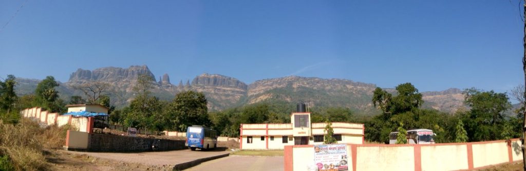
Mahuli Fort, nestled in the Sahyadri mountain range of Maharashtra, stands as a testament to the rich historical and natural heritage of the region. This article takes you on an in-depth journey through the captivating Mahuli Fort trek, highlighting its historical significance, trail details, breathtaking vistas, and the overall experience of conquering this majestic peak.
View this post on Instagram A post shared by Vicky Karande (@xpulserider)
#1. Historical Significance of Mahuli Fort Trek:
Mahuli Fort holds great historical importance, dating back to the 15th century during the reign of the Nizamshahi dynasty. The fort played a crucial role in protecting the surrounding areas and served as a strategic vantage point for several ruling dynasties, including the Mughals and Marathas. Exploring Mahuli Fort allows you to witness the remnants of ancient fortifications and gain insights into the region’s historical past.
Must Read: Prabalgad Fort Trek – Everything You Need to Know!
#2. Trail Details and Difficulty of Mahuli Fort Trek:

The Mahuli Fort trek offers a moderate-level hiking experience, making it accessible to both seasoned trekkers and beginners. The trek usually begins from the village of Mahuli, located near Asangaon in Thane district. The trail winds through lush green forests, rocky terrains, and steep slopes, providing an exhilarating journey to the fort’s summit. It takes approximately 2-3 hours to reach the top, depending on your pace and group size.
#3. Scenic Beauty and Natural Delights of Mahuli Fort Trek:
As you ascend towards the fort, be prepared to be enchanted by the stunning natural beauty that surrounds you. The trek offers panoramic views of the Sahyadri mountain range, picturesque landscapes, and the mesmerizing beauty of the surrounding valleys. During monsoon, the region transforms into a paradise with cascading waterfalls, blooming wildflowers, and lush greenery, making it an ideal time to embark on the Mahuli Fort trek.
#4. Architectural Marvels and Attractions of Mahuli Fort Trek:
Reaching the summit of Mahuli Fort rewards you with a glimpse of its architectural marvels and historical attractions. The fort complex includes ancient temples dedicated to Lord Shiva and Lord Hanuman, adding a spiritual touch to your trekking experience. Exploring the fort’s ruins, bastions, and caves will transport you back in time, allowing you to appreciate the craftsmanship and ingenuity of the bygone era.
Must Read: Kalsubai Trek- The Highest Peak of Maharashtra
#5. Tips and Precautions of Mahuli Fort Trek:
To make your Mahuli Fort trek enjoyable and safe, it is essential to consider a few tips and precautions. Carry sufficient water and snacks, wear comfortable trekking shoes, and pack a first aid kit. It is advisable to trek in a group and follow the instructions of experienced trekkers or local guides. Additionally, check weather conditions before planning your trek and avoid undertaking the hike during heavy rainfall or unfavorable weather.
Must Read: Trekking in Maharashtra – The Ultimate Trekking Destinations in Maharashtra
Preparing yourself physically and mentally for the Mahuli Fort trek can significantly enhance your experience and make the trek more enjoyable. Here are some tips to help you get fit for the Mahuli Fort trek:
#1. Cardiovascular Fitness: Engage in regular cardiovascular exercises such as jogging, running, cycling, or swimming to improve your stamina and endurance. Aim for at least 30 minutes of moderate-intensity cardio exercises, three to five times a week.
#2. Strength Training: Include strength training exercises to build muscular strength and endurance. Focus on exercises that target your legs, core, and upper body, as they will be involved in the trek. Squats, lunges, step-ups, planks, and push-ups are some examples of effective strength training exercises.
#3. Trek-Specific Training: Simulate trekking conditions by incorporating incline or stair climbing exercises into your routine. This helps prepare your muscles for the uphill and downhill sections of the trek. Find a nearby hill, stadium stairs, or use a stair-climbing machine at the gym to practice.
#4. Flexibility and Stretching: Improve your flexibility and prevent injuries by incorporating stretching exercises into your routine. Focus on stretching your leg muscles, including calves, hamstrings, and quadriceps. Stretching exercises like lunges, standing calf stretches, and seated hamstring stretches can be beneficial.
#5. Hiking Practice: If possible, go on regular hikes or long walks on uneven terrains to get accustomed to walking for extended periods. Gradually increase the distance and intensity of your hikes to build endurance and get your body accustomed to prolonged walking.
#6. Hydration and Nutrition: Stay hydrated and maintain a well-balanced diet to fuel your body properly. Drink plenty of water throughout the day, especially during your training sessions. Include nutrient-rich foods such as fruits, vegetables, lean proteins, and whole grains in your meals to support your overall fitness.
#7. Mental Preparation: Trekking can be physically and mentally challenging. Prepare yourself mentally by visualizing the trek, setting goals, and maintaining a positive mindset. Focus on the beautiful views, the sense of achievement, and the joy of being in nature.
#8. Start Early and Progress Gradually: Give yourself enough time to prepare and start training well in advance of the trek. Begin with shorter and less intense workouts and gradually increase the duration and intensity over time.
#9. Consult a Professional: If you are new to fitness or have any underlying health concerns, it is recommended to consult a healthcare professional or a certified fitness trainer before starting any training program.
Remember to listen to your body, take rest days when needed, and build up your fitness gradually. Training and getting fit for the Mahuli Fort trek will not only make the experience more enjoyable but also help prevent injuries and ensure a successful and memorable trekking adventure.
Conclusion:
The Mahuli Fort trek offers an immersive experience that combines history, nature, and adventure. It provides an opportunity to connect with the rich heritage of Maharashtra while relishing the awe-inspiring beauty of the Sahyadri mountains. Embark on this unforgettable journey, conquer the heights of Mahuli Fort, and create lasting memories that celebrate the splendor of the region’s past and present.
Must Read: Must Visit Forts in 2023 Built by Chhatrapati Shivaji Maharaj in Maharashtra
Frequently asked questions about the Mahuli Fort trek:
Q. How long does it take to complete the Mahuli Fort trek? A. The trek usually takes around 2-3 hours to reach the summit, depending on your pace and group size. It may vary based on individual fitness levels and the time spent exploring the fort.
Q. Is prior trekking experience necessary for the Mahuli Fort trek? A. No, the Mahuli Fort trek is considered to be of moderate difficulty level and can be attempted by both experienced trekkers and beginners. However, it is always advisable to be physically fit and prepared for the hike.
Q. What is the best time to do the Mahuli Fort trek? A. The Mahuli Fort trek can be done throughout the year. However, the monsoon season (June to September) is particularly beautiful as the region turns lush green with waterfalls in full flow. Winter (November to February) offers pleasant weather for trekking as well.
Q. Are there any entry fees or permits required for the trek? A. As of my knowledge cutoff in September 2021, there were no entry fees or permits required for the Mahuli Fort trek. However, it is recommended to check for any updated regulations or permissions before embarking on the trek.
Q. Are there any accommodation options near Mahuli Fort? A. There are limited accommodation options available near Mahuli Fort. Most trekkers prefer to do the trek as a day trip. However, if you wish to stay overnight, you may find basic accommodations in the nearby villages or opt for camping near the fort.
Q. Are there any safety precautions to consider during the Mahuli Fort trek? A. It is advisable to trek in a group or with experienced trekkers. Carry sufficient water, snacks, and a first aid kit. Wear comfortable trekking shoes and appropriate clothing. Check weather conditions before the trek and avoid hiking during heavy rainfall or unfavorable weather.
Q. Can I hire a guide for the Mahuli Fort trek? A. Yes, it is possible to hire a local guide for the Mahuli Fort trek. They can provide valuable insights about the trail, history, and ensure a safer and more informed trekking experience.
Please note that the information provided here may be subject to change, and it is always recommended to check with local authorities or reliable sources for the most up-to-date and accurate information before planning your Mahuli Fort trek.
Featured Image – https://images.thrillophilia.com/
Must Read: Visit to the Holy Panchvati Temple in Nashik
How useful was this post?
Click on a star to rate it!
Average rating 5 / 5. Vote count: 1
No votes so far! Be the first to rate this post.
"Travellers of India is a hub bringing globetrotters around the world together so as to reveal interesting and entertaining things about a destination, its people, and their culture. We aim to inspire Travellers around the world to delve deep into the world around them, bringing the world closer to everyone, and in doing so, making a difference in the travel genre. At Travellers of India , we focus on helping Travellers get an understanding about various destinations, things to do, travel plans, and so on. In doing so, we believe to make it simpler for everyone, and in turn, helping them experience a great and memorable journey! Here I found the best Quote about travelling “There are a Lot of stories out there waiting for you to live them” Happy Travelling".
Leave a Reply Cancel reply
Your email address will not be published.
Save my name, email, and website in this browser for the next time I comment.
You might be interested in

Harishchandragad Fort: An Odyssey through History, Mythology, and Nature in Maharashtra

Top 30 Best Places in Mumbai for Couples in 2024

Enchanting Hill Stations Near Shirdi to Fulfil Your Travel with Nature’s Gifts
- Trekking & Travel Events
- Travel Organizations
- Himalayan Treks
- Maharashtra Treks
- Karnataka Treks
- Travel Guides
- Weekend Getaways
- Trekking Tips & Advice
Mahuli Fort – 5 things to know about this terrific trek
- Trekking Destinations

Table of Contents
Mahuli Fort: A brief introduction
Mahuli fort, the highest point in the Thane district , is a popular one-day trek for Mumbai residents. The fort stands tall at 2,815ft , and is the holy grail of Mumbai’s rock climbers because of its pinnacles.
The Mughals built this fort. It is well-known for its many battles for supremacy.
- Region: Thane District
- Best Season: Monsoons & Winters
- Altitude: 2815 ft.
- Difficulty: Easy-Moderate
You can also subscribe to our monthly travel newsletter, where we give information about treks, travel hacks, travel experiences & discounts on various travel gear, and treks organised by our partner.

How to reach Mahuli fort
The fort is in the Thane district; hence it is straightforward to go to the base village via public and private transportation.
Via Public Transport:
It would be best to take a train from CST/Dadar in Mumbai, get down at Asangaon station , and board a rickshaw to the base village. The rickshaw fare is INR 250 , and it will take approximately half an hour to reach via rickshaw, and the distance is around 20 kms.
Via Private Vehicle:
The distance from Mumbai is about 70 kms , and it will take around 2 hours to reach the base village.
The distance from Pune is 200 kms .

Trek route & Difficulty
The route to the top from the base is relatively simple and well-marked; however, there are a couple of tricky sections where one needs to be careful.
It takes about 3 to 4 hours to complete the trek , and the difficulty level is easy-moderate . A beginner can attempt this trek but needs to tread carefully on certain sections; however, one needs to be physically fit to attempt the hike.
The trail starts from a gate that mentions “entry to the fort” next to a small temple. It is a jungle trail .
A gradual climb throughout the trek makes the endurance level high , and one needs to take regular stops in between to enjoy the hike.
At the top is a shivling & a sculpture of Chatrapati Shivaji Maharaj and a famous spot called the Maha Darwaza.

Important Information
- One needs to pay an entry fee of INR 30.
- The trek timings are 7 AM – 5 PM.
- A different trail leads to Mahuli waterfall, which is at its peak during the monsoons. (However, the waterfall is closed during heavy rainfalls.)
- There are no food stalls or water points throughout the trek, and one must carry 3-4 litres of water and enough food for the hike.
- It would be best if you took the contact of the rickshaw driver because there are no other rickshaws available from the base village.
- There is a small hotel near the base village where you can have breakfast before the trek.
Mahuli fort trek video
Dhodap Fort | Nanemachi waterfall | Harishchandragad | Karnala Fort | Peb Fort | Jivdhan Fort | Irshalgad | Sondai Fort | Salher Fort | Aadrai Jungle Trek | Ganpati Gadad | Korigad Fort | Tandulwadi | Garbett Plateau | Sudhagad Fort | Kataldhar Waterfall | Plus Valley | Mangi Tungi | Malanggad | Gorakhgad | Bhairavgad | Kohoj Fort | Rajgad | Ratangad | Bhimashankar Trek | Visapur Fort | Kalsubai Trek | Tikona Fort | Rajmachi Fort | Sandhan Valley | Kalavantin Durg | Andharban Trek | Harihar Fort | Kalu Waterfall
Prefer going for a trek with a group? We have curated a list of over 200 groups with their events, social media links, contact details, reviews, photos & much more.
- where is Mahuli fort situated
Kohoj Fort - A Complete Trek Guide - Nomads of India
[…] notable nearby treks include Asherigad, TakMak fort, Mahuli fort, Asava fort & […]
Add a comment
Leave a reply · cancel reply.
Your email address will not be published. Required fields are marked *
This site uses Akismet to reduce spam. Learn how your comment data is processed .
- Share via...

Mahuli Fort Trek

Mahuli Trek Mumbai Pune Adventures
Event Details
Event Grade: Easy
Endurance Level: Medium
Height of fort: 2815 ft approx.
Location: Asangaon
Total time required for trekking: 3.5 hours of normal hike and a ladder
Total distance for trekking: 8 kms apx
Duration: 1 Day
Cost: Rs.600/-
About Mahuli Fort
Mahuli Fort at 2815 ft, is a popular trekking destination and a paradise for rock climbers because of many nearby pinnacles with interesting names like Vazir, Vishnu, etc., given by the local trekking and climbing fraternity. This mountain complex is actually a group of two or more hills with common cold and pinnacles.
It is the highest point in the Thane district. The forest surrounding Mahuli has been declared as a sanctuary. Once Shahaji Raje, father of Chhatrapati Shivaji Maharaj, had this fortress. The fort has been declared as a protected monument
Besides an open Shiva temple there is a small perennial drinking water cistern on top, three caves of which the larger can be used as overnight shelter, like as on many other such natural hill forts of Maharashtra Western Ghats (Sahyadri Range). There is a stone arch historically known as the ‘Kalyan Darwaja’ but the dome of the arch is now broken.
Major Attractions:
- Day Trek full of adventure
- Traversing the fort
- Hike through the woods
- View from the top of Fort and the cool breeze
- Adventures and easy ladder climb
Travel Schedule
We’ll be boarding the below train from nearest local station. Train timings are shared below for convenience:
Kasara Fast Local
06:55 am CST
07:02 am Byculla
07:08 am Dadar
07:15 am Kurla
07:19 am Ghatkopar
07:35 am Thane
07:47 am Dombivli
07:54 am Kalyan
08:34 am Asangaon
Meeting Point : Asangaon Railway Station at 08:45 am
08:45 am Meet-up, and leave for base village of the trek
freshen up, have tummy tight breakfast and gear up for the trek
09:15 am Introduction round and brief on rules and regulations to be followed by everyone on the event
09:30 am Continue with the trekking in the woods
12:30 pm Reach Mahuli Fort, Have lunch self carried on the trek followed by some rest and then explore the surrounding,
01:30 pm Start descending towards the base village
04:30 pm Post all the masti and after clicking loads of pics, we will reach our base village, freshen-up and have some refreshments
05:30 pm Move for Asangaon via local transport, and take a return train to mumbai
07:00 pm Reach Mumbai and bid adieu with a promise to meet soon
Event Fee: Rs.600/- per person. Payment once done is non-refundable, do check for availability before making a payment.
Payment Details
Deposit the Amount into the Following Account:
Name: Mumbai Pune Adventures
Bank: Central Bank of India
Account: Current Account
A/c No. : 3601915663
IFSC Code: CBIN0284592
Payment terms:
https://www.mumbaipuneadventures.com/terms-conditions/#payment_policy
The cost per head includes the following.
- Unlimited breakfast in the morning
- Tea in the morning
- Evening snacks
- Local guidance
- First aid and first responder assistance in case required
- MPA administration charges if any
- Do read our terms and conditions before registration
Cost Excludes
- All kinds of extra meals / soft drinks ordered.
- Insurance, tips, porters, bottled mineral water, aerated drinks etc.
- Any kind of personal expenses.
- Any kind of cost which is not mentioned in the cost includes above.
- All expenses incurred due to unforeseen and unavoidable circumstances like road blocks, bad weather.
Things to carry
- Some ready to eat food like- plum cakes, fruits, chocolates, biscuits, etc
- 2-3 Litres of water must
- Good trekking shoes
- Extra pair of clothes, socks optional
- Cap, Camera as Optional
- 1 packet of electrol, enerzal, glucon-D
- Medications if required for individual
- Avoid wearing precious ornaments on an event, if possible
- And a haversack or backpack to put all the above things to be carried, so hands are free to help each other while trekking. Sling bags / jholas / trolley bags etc not allowed on the event. Please pack accordingly.
Write to us at:
Keep visiting us at:
https://www.mumbaipuneadventures.com/
Follow us at:
https://www.facebook.com/mumbaipuneadventurespage/
Terms and conditions:
https://www.mumbaipuneadventures.com/terms-conditions/ Mahuli Trek Mumbai Pune Adventures
Meeting Point
Required fields are marked *
Select Batch
Related this week events, other events, rajmachi - fireflies.
- Price : Rs. 1490
Kothaligad Trek - fireflies
- Price : Rs. 1100
Dhangar Waterfall Rappelling
- Price : Rs. 1200
Kalsubai Night Trek - Fireflies
- Price : Rs. 1150
Pawna Lake Camping
Kalsubai trek from pune, andharbantrek from pune.
- Price : Rs. 1450
Chadar Trek
- Price : Rs. 24500
Mahuli Fort Trek (Maharashtra) – Complete Travel Guide
Brief about mahuli fort trek.
I recently went trekking to Mahuli Fort and it was an unforgettable experience. Situated on a solitary hill on the western side of Shahapur, Mahuli Fort is part of the Sahyadri range. It is a popular trekking spot, especially for rock climbers and corporate professionals who are looking for an adventure close to the city.
The trek is known for its lush green forests and meadows that offer stunning views of the surrounding landscape. It is especially beautiful during the monsoons when you can enjoy the cool breeze.

The trek to Mahuli Fort starts at the base, where you can visit the local temple and get a map of the trek. The fort was built by the Nijamshahi dynasty and was later taken over by Chhatrapati Shivaji. It remained under the dynasty of Shivaji until 1817, after which the British took control.
Mahuli Fort is a complex group of hills that share pinnacles and cors, and it offers a spectrum of green landscapes that will surprise you. I highly recommend this trek to anyone who loves the outdoors and wants to experience the beauty of nature.
Key details of the Mahuli Fort Trek:
- Ideal Number of Days for the Visit : 1 day
- Trek Distance : 6 km one way
- Trek Altitude Range : 2815 feet
- Starting Point: Mahuli Village
- Nearest Railway Station : Asangaon Railway Station (78 km)
- Nearest Airport: Chattrapati Shivaji Maharaj Airport, Mumbai (74 km)

Table of Contents
Best places to visit at mahuli fort trek.
During the trek, you can explore the picturesque village of Sakawar, which is the starting point for Takmak Fort trek. This village portrays a typical Indian countryside life, with children playing and women doing laundry in the nearby streams, while men cultivate rice paddy fields.
The Palghar region of Maharashtra is known for its dense forests, which are home to a rich variety of flora and fauna, including Curculigo Orchioides and starflowers . These flowers bloom in the monsoon season, covering the entire trail with tall green grass and flowers, providing a tranquil and peaceful experience for trekkers.
Additionally, the forested region on this trek is home to many species of freshwater crabs, including cream and pink-colored ones. Observing these crabs and learning about the 11 different crab species in the Sahyadris is an interesting and unique experience.
Finally, the Takmak Fort features a well-maintained cannon , a few rock-cut cisterns, and the remains of some buildings.

What is the best time to visit Mahuli Fort Trek
The best time to trek to Mahuli Fort is from June to February. Post-monsoon , from September to December is the perfect season for trekking as the trail is filled with dense vegetation, and the fields and trails are covered with green grass. In the other months, the vegetation will be dry.
Monsoon season, from June to September, offers spectacular views of the lush green Sahyadris, while post-monsoon season provides a clear view of the famous forts and peaks from the top, with pleasant weather.
How to reach the starting point of the trek?
Mahuli is easily accessible by public transport from Mumbai .
The best way to get there is to take a local train to Asangaon , which takes around 2 hours from Mumbai CST. From Asangaon Railway station, you can easily get an auto or bus to Mahuli Fort.
Buses run from Asangaon to Shahapur, where you have to change the bus to reach Mahuli. The tickets are priced at Rs.15.
You can also reach Shahapur by sharing an auto for Rs. 10/seat from Asangaon, or take an auto directly to Mahuli base for Rs. 250 for 3 people.
Remember to collect the contact numbers of the auto drivers and fix the price for the return journey or you might be charged higher.
Availability of accommodations and food near the trek
For food options at Mahuli Fort, there are a few restaurants on the way, but they become limited as you move farther away from the base village. The last restaurant can be found at Bhakt Niwas just before the trek trail starts. It’s best to carry ready-to-eat food, 3-4 litres of water, and a mat/bedsheet for rest.
Accommodation:
Camping on the Mahuli trek is not allowed, so you can pitch your tents at the base of the trek at Bhakt Niwas. If you’re looking for more comfortable options, there are several hotels in nearby towns like Asangaon and Shahapur.
Alternatively, you can stay in Mumbai in a great hotel/resort of your choice and head to the trek directly from there.
- Check Hotels & Resorts in Asangaon
- Check Hotels & Resorts in Mumbai

The Difficulty level of the Mahuli Fort Trek
The trek to Mahuli fort is easy-moderate with a well-marked trail from a gate next to a small temple. It takes 3-4 hours to complete the trek, and regular stops are required. There are a couple of tricky sections, and it’s essential to be physically fit to attempt the hike.
The top features at the top are a shivling, a sculpture of Chatrapati Shivaji Maharaj, and a spot called the Maha Darwaza. Wild animals are visible in these areas, with leopards spotted frequently in the past, resulting in trekking restrictions.
Preparation required for the Mahuli Fort Trek
Mahuli Fort is surrounded by dense vegetation, and wild animal sightings are common, especially during the monsoon season when wildflowers offer a warm welcome.
In the past, leopard sightings have resulted in restrictions on trekking activity in the area. Waterfall rappelling is organized here, but travellers are warned to avoid it during the monsoon season, as many fatal accidents have occurred in the past.
It is recommended that travellers wear trekking or sports shoes and comfortable, earthy-colored clothing.
Nearby Destinations you may want to explore:
- Ratangad Fort Trek – Ahmednagar, Maharashtra
- Takmak Fort Trek – Virar, Maharashtra

About The Author, Anant
Anant is a seasoned traveler and product professional, who is passionate about exploring new products, destinations and cultures. He captures all his experiences through his love of writing. Driven by a desire for adventure and knowledge, Anant is on a quest to see as much of the world as possible.
Related Posts

Bandaje Falls Trek (Ballarayana Durga Fort) – Travel Guide
Save my name, email, and website in this browser for the next time I comment.

Mahuli Fort is a protected monument. It is situated around 90 km from Mumbai. It is a good getaway for people in Mumbai/Thane or nearby places and a paradise for rock climbers. This trip was taken by a group of friends and is suitable for anyone who is passionate about trekking and rock climbing.
HOW TO REACH
- Local train from CST
- Buses/Taxis/Self-drive from Mumbai or Pune
INDICATIVE BUDGET
INR 700-800 per person per day.
WHAT AND WHEN TO DO
- Take a local train from CST to Asangaon
- Get an auto till the Mahuli village
- Have breakfast in the village, snacks carried by you/ arrange it with the help of locals – if you haven’t had
- Reach at the starting point and start the ascend
- Enjoy the views on the way and on the top
- Xplore the ruins of the fort, surrounding points near the hill top, and have lunch
- Start the descend and reach back
THINGS TO SEE ON THIS TREK
- Open Shivling
- Three caves on the trek
- ‘Kalyan Darwaja’ – a historical stone arch
- From chota Mahuli while walking for 10 mins u reach a wall called “Namazgir” – A wall believed to be a place of worship for the Muslims (10 mins walk from Chota Mahuli.
- Old ruins of house and stables on the trek
- A beautiful view to Tansa lake. Source: https://www.treksandtrails.org/blog/mahuli-fort-trek/
ABOUT THE TREK AND HELPFUL TIPS
- The Mahuli Fort Trek is a moderate to difficult level trek. There are many thin and steep spots that one has to cross in the trek. This is a combination of 2-3 hills. During monsoons, the trek can be slippery, but it also has the best views during that time.
- The best time to visit is between June to December. You can Xperience views of dense vegetation and the waterfall is also not dried up.
- Food can be arranged at the base village. Carry enough water for the trek as you might not get it on the top.
- You should return before it gets dark. A leopard sanctuary is around this place and leopards have been spotted near this area several times.
SOME PICTURES FROM THE TRIP
This Itinerary was contributed by a Community Member!

Another place near Mumbai that is perfect for a weekend getaway is camping at the Pawna Lake .
Ensure you travel responsibly and keep your carbon footprint to the minimum. Happy Xploring!
Want to share your experience and tell everyone about how you travel and plan your trips? Now you can, in just a few steps! Head out to Share your Trip page now!
Xclusive Merch Launched


Search This Blog
Friday, april 17, 2020, mahuli fort- a trek that make you more photogenic.

MAHULI FORT- A TREK THAT MAKE YOU MORE PHOTOGENIC
About mahuli fort, how to reach mahuli fort, history of mahuli fort, treking to mahuli fort.

PLACES TO SEE AROUND MAHULI FORT
Ideal time to visit mahuli fort, places to stay around mahuli fort, food availability at mahuli fort, things to remember before visiting mahuli fort.
- Don’t try to visit Mahuli waterfall if it is restricted by officers from Entrance gate. Several live has been lost here.
- While passing jungle trail, be aware of snakes.
- Try to avoid taking selfie’s if passing from ladder trail.
- If you are taking auto from Asangaon to Mahuli, then also take contact number of Auto driver, because while returning from trek there won’t be any Auto’s.
- Start the trek before 12 noon, entry gets close after 12 noon.
- Carry some water and snacks with you, on route there are no option available.
- Do not drink on fort and litter the area around fort.
3 comments:
I like it very much! Keep this going!
This blog was very interesting and informative.
Interesting detailed blog
Contact Form
Subscribe to.
Total Pageviews
Blog archive.
- Bhandardara
- Difficult Trek
- Forts at Panvel
- Golden Temple
- Haunted place
- Hill station
- Historical Place
- Holiday village
- Honeymoon destination
- Matheran Hill station
- Medium trek
- Monsoon Trek
- Rockclimbing
- Romantic Place
- Tamhini Ghat
- Uttarakhand
- Valley of Flowers
Report Abuse

Mahuli Fort Trek
Mahuli Fort is located near Mahuli Village in the Thane District of Maharashtra. Mahuli has a long history culminating with the Maratha empire in the 18th century. It is a cluster of 3 forts very close by- Mahuli, Bhandargad & Palasgad. Mahuli Fort is at 2815 ft, which is the highest point in the Thane district, hence it is also known as Everest Of Thane. The trek route offers some exceptional views of adjoining mountain ranges; also being a part of the Tansa Wildlife, Sanctuary there's a chance of spotting some rare species of flora and fauna especially in the monsoon.

Mahuli Fort is a paradise for rock climbers because of many nearby pinnacles with interesting names like Vazir, Vishnu, Navra, Navri, Mahuli-Chanderi etc., given by the local trekking and climbing fraternity. Palasgad is northern side, Mahuli is in the middle and Bhandargad stands on the southern side. The entire trek from base to the summit is an easy grade level trek but requires high endurance.

How to Reach From Mumbai?
Mumbai Local Train: The cheapest and most convenient way to reach Mahuli base village of Mahuli Fort Trek for Mumbaikar is through Local Train (Central Railway). Take a local train till Asangaon railway station. I suggest taking 10:50 PM from CSMT which will reach Asangaon by 01:00 AM. From Asangoan Railway Station you can get a rickshaw easily for Mahuli Village. which will cost you ₹300 one way for a 6 km drive from the station to the base village in 20 minutes. It is advisable to take the contact numbers of the autowala so that you‘ll have some alternative for the return trip. Confirm the fare for the return trip beforehand.
Mr Raghunath Krushna Agivale (+91 78753 22744) one point of contact for everything you need - a place to relax for the rest of the night, breakfast, lunch, a local guide and a friend. He is also a member of the Maharashtra Mountaineers Rescue Team and lives in Mahuli Village.

Alternatively, buses ply from Shahapur to Mahuli with ticket priced at ₹20. You can reach Shahapur by sharing an auto for ₹15 per seat from Asangaon or alternatively, catch the bus as it turns towards Mahuli from the highway opposite Asangaon station. The first bus from Shahapur bus stand leave at 06:30 AM and the last buses to Shahapur from Mahuli leave at 06:00 PM, so plan your travel accordingly.
Private Car: If comfort is your priority and travelling in a group go by car. Mahuli is well-connected to Mumbai by roadways (NH3 - Mumbai Nashik Highway) it will take around 2/3 hours with a break. The road is well constructed. Several ATMs, petrol pumps, hotels, restaurants and banks are located on the route. Just make sure that you download the area before starting your journey because you might lose the signal multiple times on the way.
History Of Mahuli Fort
Mahuli’s historical significance lies in the various eras of rulers who have ruled here. Beginning with the Mughals who created the fort, it came under the rule of the Nijamshahi dynasty in 1485. It was later on won and sacrificed by Chatrapati Shivaji Maharaj twice, passing it back to the Mughals in the treaty of Purandar. In 1670, when Gaud was in charge of the fort, Marathas attacked the fort again, but ended up losing a gem, Sardar Kadam, later named ‘Sonare’ (Gold of Swarajya) by Chatrapati Shivaji Maharaj. By mid-1670, the fort was conquered by Moropant Pingle and added to Swarajya. Around 1,700 different climbing pinnacles surround this fort, making it a fort worth fighting so much for.

Paradise For Rock Climbers
Mahuli trek begins from its base village - Mahuli village. There is Lord Shiva temple at its base. There is an entrance gate that welcomes all the trekkers. You can park your two-wheeler her. There are no parking fees, but you have to pay an entry fee of ₹20 as this fort is maintained by Maharashtra Government.

The initial trek route is simple and you will come across a bridge which has been built recently to help ford it during monsoon when it tends to swell dangerously after a heavy downpour. The trail is well-marked till the bridge along with the diversions to the waterfall and a dam. The waterfall can only be seen in the monsoon because the stream gets dry by the start of winter. Mahuli fort trek route is well marked with arrows and proper signboards. I suggest stick to the marked trail which is Mahuli Village – Forest Entrance Gate – Newly Constructed Bridge – Jungle Trail – Multiple Rock Patches – Ridge – Iron Ladder – Mahuli Fort Top. There is proper white arrow marking at regular intervals for people to follow.

The initial climb is very gentle, but as you go higher it became steeper. Within 30 minutes of walking uphill from the bridge, you will come across a flat patch of land know as Koti Plateau.
Koti Plateau is also one of the best locations in the region for doing star gazing.

Continue from here you will enter a spare forest. The landscape turns arid as you approach the ridge. The path here skirts the southern edge but the valley is gently sloping and therefore, fairly safe. You would see the orange flag fluttering on the dilapidated fort tower from the base of the ridge (Tadmachi Plateau).

Climb onto the ridge through a steep crevice. Take a left from the crevice to head towards the fort and take right to reach a vantage point on the ridge to soak in the views. The path which is heading toward the fort is called Ghodacha mana (Neck of Horse).

A 15 min walk along the ridge takes you to the base of the plateau of Mahuli fort. The route zigzags upwards with a couple of simple rock patches along the way.

We could see the famous ladder on the wall as we reached the fort. It is placed at an angle of 70° but that isn’t the main problem. The issue is that the ladder doesn’t have a firm base at the bottom and is held in place with a chain tied to a screw bolted in the dilapidated fort wall at the top. Also, the rungs aren’t horizontal but slant towards the valley. This makes you lean back while climbing the ladder, which isn’t too convenient. One person held the ladder at its bottom while others climbed it one at a time.

A narrow path to the left of the ladder goes into the fort whereas the right takes you to a flat rock which is the most clicked area of Mahuli. Five minutes of walk from here brings you to a small tank but sadly doesn't have potable water.

After another 15 minutes of walking downhill from the small tank following the marked trail for Maha Darwaza, you will reach the Mahuli Fort. On the fort under a tree above the caves, there is a Shivling (open Shiva temple) along with idols of Lord Hanuman and Chhatrapati Shivaji Maharaj and with another Maratha flag. From this tree, we could see the fortification walls around the mountain. Following the step which leads towards the caves ( Of which larger can be used as overnight shelter ), you will see a stone arch historically known as the Maha Darwaza, the erstwhile main entrance to the fort in its glory days. But the dome of the arch is now broken This was the gate for the route from Kalyan but the steps were blown away by the Britishers in the 19th century. If you plan to take this route, Vashind is the nearest station but be warned that it isn’t in use anymore and requires serious rock climbing skills.

Take a break to eat something before starting to descend which will usually take less than half the time you take to climb any fort but not in the case of Mahuli it was not that easy. It is the same route you have taken to climb up.
Best Season to Visit Mahuli Fort
The best time to do the Mahuli fort trek is from June to February. During this period you can see the spectacular views from Mahuli fort.

Monsoon is the best season to see the lush green Sahyadris. All the fields in the villages and trails will be full of green grasses. Post monsoon season offers a clear view of the famous forts and peaks from the Top. You can expect pleasant weather during this time.
I genuinely believe people form bonds with mountains. As Ruskin Bond has succinctly put it-
“It is always the same with mountains. Once you have lived with them for any length of time, you belong to them. There is no escape.”
The good part?
I don’t intend to escape! 🙂
Listen To Me:
Carry some ready to eat food, atleast 3-4 litres of water and a mat/bedsheet to rest. There aren't any food options available during the trek at Mahuli Fort
Talk to the native villagers gently and give respect to them, because you are their guests.
Wear full sleeves T-shirt and Pant, that will protect you from the wild insect. I ts a jungle, we are bound to bump into these wild insects like leeches. If possible carry a walking stick also.
An empty tiffin box to carry lunch or refreshment.
Carry an Id proof.
Trek Level: Easy but High Endurance
Base Village: Mahuli, Thane - Maharashtra
Altitude: 2815 ASL
Time Required: 5 - 6 hours round way.
Region: Thane District
If this has inspired the explorer in you, you may also like to explore...
I am one of you only and if you found the write up useful, would love to hear your feedback in the comment section. do share, like and follow for more on facebook , instagram , twitter , telegram & whatapp ..
- Weekend Getaway From Mumbai
- Adventure Travel
Related Posts
Dudhsagar Waterfall Trek - The Beauty Of Goa
Cave Behind A Waterfall - Ganpati Gadad Trek
Harihar Fort Trek - The Iconic Climb In The Sahyadris
Commentaires
Mahuli Fort – An Ankle Twisting Climb to Thane’s highest point

Backpacking in Western Ghats comes with a lot of surprises. The pristine views that you get from your friend’s apartment in Thane is nothing less than a high end resort. But as a North Indian, I entered Maharashtra with the notion that trekking means Himalayas. Now I realize how wrong I was!
One weekend, my friend told me that they are going for a trek nearby and if I wanted to join. Trekking in Thane sounded like a joke and I assumed that they are going to climb some local rock formation like I did at Kanheri Hills. This destination was Mahuli Fort and is the highest point in Thane District.

But, Mahuli Fort is located at a height of 2816 feet and for a Western Ghats location it is not to be taken lightly.
Reaching Mahuli Fort – Asangaon is the nearest railway station from Mahuli. This local can be taken from Mumbai CST or Kalyan Junction. From the station, the base temple is about 4 km away and you can either hire a rikshaw or walk. Once you are at the base, the trek for fort can be completed in 3 hours.
Most of the locals who trek to Mahuli fort, camp at the temple that they use at base. A couple of trek groups from Mumbai and Pune come here with their own gear, travel overnight, reach early morning, trek and then return to their respective cities. For the Mumbaikars, Mahuli fort is a perfect weekend getaway.

Mahuli Fort is one of those treks where you need to start in the morning. As the sun comes out, the whole area becomes bright and the shades of green simply start showing up in every corner. The trek starts from Manas temple and any local would show you the way. Many trekkers prefer climbing the fort during the monsoon season but trust me, the post monsoon and the winters are the best time to visit. When you reach the base camp in the morning, you are welcomed by a thick patch of fog floating on the surrounding hills. Rain can delay your plans but the months of October and November prove to be perfect to go on an uninterrupted hike and return to station on time.

It is hard to believe that this location is just 3 hours outside Mumbai where the humidity is ready to kill you any time (speaking from a visitor’s perspective). Our trek went by a rocky patch of road with think green grass on both sides. Mind couldn’t stop but wonder what if a snake comes out and attacks out of nowhere. There were leeches but a trekker who had come here in monsoon and couldn’t trek said that more of these tiny creatures come out when it rains. They even infest the camping area during that season.
After an hour of straight walk the climbing portion arrived and it was nothing like any of the ascents I had done in Karnataka side of the ghats. It became an instant 70 degree angle and one by one people started falling. Somehow, we got over that portion too and the views of the fort were right in the sight.
But by then, my legs had given up on me. Fallen down twice and twisting my ankle made me regret coming on this trek. Worse than that, I cursed myself for underestimating a trek that was ‘right outside Mumbai’.
Mahuli Fort is a gorgeous spot and once you reach here, there is a new flow of energy inside you. The views around the fort and really amazing and there is a beautiful waterfall right in the sight but impossible to reach.
Mahuli Fort is a winter trek and not a monsoon one because you’ll not get to enjoy these serene views.

Points to remember before trekking Mahuli
Wear proper trekking shoes and not any casual sport shoes. Underestimating this trek is the biggest mistake.
Carry rain gear because mild drizzle is possible
Don’t walk from station to Mahuli temple because it will kill your energy for trek
Arrive early morning and rest at the temple. Morning train will delay your trek as you will have to return back before 5 PM

WSR Outdoors One Day Trek to Mahuli Fort On 10th October 2021
Short Info:
Grade: Easy
Endurance Level: Medium
Height: 2815 ft approx.
Location: Asangaon
Total distance for trekking: 8 kms apx
Cost: Rs.699/- Per Person
Rs.649/- WSR Members
Leads: Mayur / Tanmay
Mahuli Fort, located 2815 ft above sea level, is a popular trekking and rock climbing destination. The nearby pinnacles, including Vazir and Vishnu, contribute to the enduring popularity of the location. The mountain complex consists of a group of two or more hills with common cols and pinnacles. It is the highest point in Thane District. The forest surrounding Mahuli has been declared a sanctuary. Shahaji Maharaj, the father of Shivaji, occupied this fortress. The fort has been declared as a protected monument. Besides an open Shiva temple, there is a small perennial drinking water cistern on top. The location also contains three caves, of which the larger one is sometimes used as overnight shelter, like on similar natural hill forts in the Maharashtrian Western Ghats (Sahyadri Range). There is a stone arch historically known as the 'Kalyan Darwaja', but the dome of the arch is now broken.
In 1635-36, Shahaji, an Indian military leader of the time, moved with Jijabai and Shivaji to Mahuli. When Khan Jaman attacked on the fort, Shahaji asked the Portuguese for help, who refused and Shahaji surrendered.
Shivaji took this fort from the Mughals on 8 January 1658, but lost it in 1661, and later won it back. By the treaty of Purandar of 1665, the Marathas lost these forts again. In February 1670, Shivaji tried to conquer Mahuli, but failed, and Manohardas Gaud was then in charge of the fort. A thousand Marathas were killed, most being from nearby villages. Shivaji said to his dead kadam sardar that he was our gold. So he gave the Sonare surname to this family. Manohardas Gaud soon gave up his position and Alveerdi Beg took over. On 16 June 1670, after two months, Moropant Trimbak Pingle conquered the forts and Mahuli, Bhandargad and Palasgad became part of Swarajya. Until 1817, Shivaji's dynasty owned the fort but later on it was controlled by the British Raj.
Train Time Table: 05:12 am, CSMT - ASANGAON (slow)
05:12 am, CSMT
05:20 am, Byculla
05:30 am, Dadar
05:40 am, Kurla
05:46 am, Ghatkopar
06:02 am, Mulund
06:07 am, Thane
06:29 am, Dombivli
06:40 am, Kalyan
07:16 am, Asangaon
Meeting Point: Near Railway Bridge at 07:20 am
Proceed to Base Village by Local Transportation
08:00 am, Reach Base village and breakfast time
09:00 am, Start Trek
12:30 am, Reach Top
have lunch, explore the fort
02:00 pm, Start for our return journey
05:00 pm, Reach Base village and travel till station by local transportation
Tentatively we can catch 06:15 pm CSMT (SL0W) / 06:55 pm CSMT (FAST)
Reach Mumbai by 08:30 pm
Breakfast & Evening Refreshments
Asangaon to Asangaon by Local Transportation
WSR Expertise Charges.
Mineral Water, Cold Drinks
Any kind of Insurance
Anything which is not mentioned in includes
Things to be carried:
Identity proof (Must)
Lunch (Must)
Some ready to eat food. Plum cakes, Biscuits etc.
A bottle of water (atleast 3 Ltrs) (Must)
Bunch of Papers, Camera, Cap etc.
Medicine those if u require usually (Optional)
A good trekking shoes, extra pair of flotters.
A haversack to put in all the things to be carried....so that one has ones hands free while trekking.
Please avoid wearing Gold and other ornaments.
It might rain, so pack your bags accordingly to save them from getting wet. Double pack your valuables in plastic bags
Please read our "Terms & Conditions" before joining for any events.
For Registrations call Team WSR:
Deepak: 8830325868 / 9699648235 (Whats App)
Mayur: 9769767696
If not reachable do sms or whatsapp.
Email id: [email protected]
Website: www.wanderingsoulriders.jimdo.com
Payment Details:
Booking only through 100% Advance payment
The amount is to be deposited in the following account.
Account No: 0228101827925
Name: Deepak P Jat.
IFS code: CNRB0000228
Type: Saving
Bank Name: Canara Bank
Branch: Naupada, Thane (w)
Gpay / Phone Pay / PAYTM: 9699648235
Once payment is done, please send an email to [email protected] with Transaction ID, Participant Name, Email ID, Cell Number
Cancellation and Refund Policy:
1. If cancellation done prior to 10 days of outing 75% will be refunded.
2. If done prior to 5 days of outing 50% will be refunded
3. After that no refund will be provided.
Medical Disclaimer:
It is mandatory that you visit your personal physician before enrolling for the trip if you suffer from any illness of any kind and disclose the same and your medical history to the organizers of the trip so that best possible arrangements can be carried out post approval. As organizers of the trip, we will be responsible for providing basic first aid throughout the trip. In case of unexpected mishaps or accidents, we will arrange for the injured patron to be taken to the nearest medical hospital wherever possible. The medical expenses will have to be borne by the patrons themselves.
You can do it, too! Sign up for free now at https://www.jimdo.com
- Scroll to top
Mahuli Fort

Top ways to experience nearby attractions

Most Recent: Reviews ordered by most recent publish date in descending order.
Detailed Reviews: Reviews ordered by recency and descriptiveness of user-identified themes such as wait time, length of visit, general tips, and location information.

Also popular with travelers
Mahuli Fort - All You Need to Know BEFORE You Go (2024)
- (5.97 mi) On The Go Resort
- (4.31 mi) Hidden Village
- (5.27 mi) Kisan Eco Farm Wooden Cottage
- (6.60 mi) Mars Farmhouse & Nature Resort
- (4.96 mi) Routecamp
- (3.24 mi) Food Hub,
- (3.23 mi) Shubh Sagar
- (3.24 mi) Restaurant at Hotel Parivaar
- (6.08 mi) Diamond Foodway by Mahanagar Motels
- (4.44 mi) Hotel Paramount Veg Restaurant,
Fort Russell Neighborhood Historic District
Moscow city , latah county , id, home | whats new | site index | contact | search.
- Post Office: Moscow
- Zip Code: 83843

Photo: Looking West down B Street in the Historic District, Moscow. The Historic District on the National Register of Historic Places in 1980. Photographed by User:Davidlharlan (own work), 2012, [cc-3.0 ], via Wikimedia Commons, accessed March, 2023.
Original nomination [1]
The Fort Russell Historic District consists of 116 structures in nine square blocks, and fractions of twelve contiguous blocks, in the hilly northwest section of Moscow, Idaho. The district is almost totally residential in use. Only three buildings near the perimeter stand as exceptions: a school and two church buildings, one still used for worship and the other in service as a Senior Citizen's Club. These uses reflect the ambience of the neighborhood and its environs; it is an old residential area, its southeast corner within a few blocks of Main Street, ringed with service institutions: three more school buildings, four more churches, a Carnegie Library, the Post Office and Courthouse, and a city park are within a few blocks of the district. There are no commercial intrusions within it.
The district is strongly homogeneous not only in use but in style, scale, and, as it were, texture. The houses are predominantly from the late Victorian to early twentieth century periods. Fine examples of Queen Anne , Eastlake , Gothic Revival , Colonial Revival , Classic Box and Bungalow appear. In most of these styles, examples occur on both the "mansion" and the cottage scale. Not unexpectedly, this is especially true of the Bungalow style. The pattern prevalent in many turn-of-the century neighborhoods—whereby large homes are built on the corners of blocks, which later fill in with more modest dwellingss—holds true for the Fort Russell neighborhood. But while structures in the district range from small to grand, none exceed two- and-a-half stories, and most are one or two. Finally, the homogeneous streetscapes of residential, structures built largely from 1880 to 1920 and in related styles and scales are knit together by the texture of building material—mostly frame and brick&m dash;and by the texture of the rows of mature deciduous trees which distinguish the neighborhood and contribute much to its character.
The significance of the Fort Russell neighborhood District is both architectural and historic. It is manifestly significant for the rich display of early residential architecture it provides in a town of under 20,000 residents. It is significant as well for the historical connections between the houses and many of the people who built the town: the early entrepreneurs and professionals whose commodious homes expressed their positions of leadership in the community, and the more anonymous citizens whose neat cottages and bungalows grew up between the big houses—indeed, were sometimes built by the owners of them—a generation or two later.
The architectural interest of the district is immediately apparent to the eye. As specified in Section Seven, a neighborhood larger than the area which could reasonably be nominated as an historic district is generally continuous with it, and contains individual structures of substantial significance. It is noteworthy that five National Register properties the Cornwall house, the McConnell mansion, the Carnegie Library, the Methodist church and the Federal Building are located in the less architecturally cohesive but still handsome blocks to the south and west of the district. Moscow's Main Street, which contains a high percentage of early buildings, is only a few blocks further west. Thus perhaps a fifth of the area of this small city a town devoted primarily to servicing the wheatlands round about and the University of Idaho on the west side of town turns out to be of unusual architectural calibre. The Fort Russell district is the most architecturally cohesive core of this generally rewarding area.
Additional nomination [2]
Like Moscow's downtown, the Fort Russell neighborhood began developing during the last few decades of the nineteenth century, with the earliest dwelling dating to 1875 according to City of Moscow GIS property data. A total of 59 of the 243 total sites, nearly one full quarter (24%) within the district's expanded boundaries date prior to 1900, with construction and commerce slowing nationally during the mid-to-late 1890s as a result of the national financial crash that hit in 1893. Once construction began again, around the turn of the century, the neighborhood experienced a major boom with approximately 13% dating to the single decade between 1900 and 1910 at which time Moscow was growing rapidly as a regional commercial center. Approximately 18% of the buildings within the expanded district were then built between 1911 and 1920 as the city continued to grow steadily, another 14% between 1921 and 1930, and finally 20% going up between 1931 and 1940 indicating that residential growth continued at a higher rate than commercial growth during the Great Depression years of the 1930s during which only three commercial structures were built in the downtown district. The remaining 11% is made up of 26 post-1940 dwellings scattered throughout the neighborhood.
The Fort Russell Neighborhood Historic District represents a "rich display of early residential architecture ... significant as well for the historical connections between the houses and many of the people who built the town." It is associated with events, including community planning and development, education, entertainment and recreation, and religion. The District is an embodiment of the architecture and landscape architecture during the period of significance. The neighborhood retains a strong historical character and continues to represent its period as an intact historic district within the city of Moscow. Notwithstanding the presence of some modern buildings the district today retains integrity of location, design, setting, feeling, and association, and though some changes have been made over time to individual dwellings, overall integrity of workmanship and materials is present.
The expanded period of significance for the district begins in 1875, the earliest recorded construction date for any resources within the district boundaries, and extends through to 1940. The district exists as an early residential neighborhood with strong ties to the city's earliest pioneers and businessmen who were responsible for settling, establishing and growing the city and its economy. Post-1940 buildings are scattered in relatively small numbers within the proposed boundaries (accounting for just 11% of buildings within the expanded boundaries). Though modern construction begins to represent a different character moving beyond the period of significance, the presence of these buildings does not detract from the district's strong character and identity as a significant neighborhood reflecting Moscow's early growth.
In the area of architecture, the Fort Russell neighborhood is significant for its residential, educational, and religious buildings and its overall built character, which correspond to the first several decades of the city's growth and development. Both the high-style architecture of the late-nineteenth and early-twentieth centuries, including Victorian styles such as Queen Anne, as well as the more modest, accessible architecture of the 1920s and 1930s, such as Bungalows and English Cottage or Tudor Revivals, are found within the Fort Russell neighborhood. Though the architecture within the district varies resulting in an eclectic collection of buildings, the architectural forms and styles within the neighborhood are directly representative of national architectural trends for each decade during the period of significance, as well as representing the economic, social, and demographic patterns of city of Moscow itself.
The Fort Russell neighborhood's significance in the area of community planning and development is similar to what has been outlined for architecture, following both national and local trends related to economics and community development. The various additions within the district were platted during the city's earliest days, being laid out generally in a grid pattern with spacious lots intended to serve as an escape from the city's bustling town center. Over time, many of the lots were subdivided and filled in with smaller, more modest dwellings on smaller lots during the 1920s and 1930s accommodating the city's growing middle-class population while continuing to support the entrepreneurs that helped build it up originally. The planning and development evident within the Fort Russell neighborhood is also reflective of its central location, containing not only residential development but also schools, churches, and a major city park, all woven in to accommodate the needs of this diverse neighborhood as well as the needs of the city's general population who could access this area easily since it lies within walking distance to the city center.
Entertainment and recreation, and landscape architecture are related themes within the Fort Russell neighborhood, being represented by the planning and development throughout the neighborhood as well as by East City Park, which is situated in the southeast corner of the expanded district boundaries. This park was laid out in its original location and form during the city's earliest days—being reflected on the earliest city maps and Sanborn maps. The presence of the park reflects early intentions at providing recreation and embracing formal landscape architecture, by positioning the park within a reasonable distance of the city center so that it was accessible, yet removing it far enough from the central business district to ensure a relaxing, enjoyable environment within the park. Parks established around the turn of the twentieth century were intended to provide a rural- or countryside-style escape for city dwellers who were often unable to interact with the natural environment in any other way. Landscape architecture is additionally present within the neighborhood through the generally consistent grid pattern, setbacks, tree-lined properties, and landscaped residential yards found throughout.
In the areas of education and religion, the Fort Russell neighborhood is significant for containing a number of these buildings. The expanded district boundaries contain two schools, John Russell Elementary built in 1928 replacing an older school on the same site, and the old Moscow High School, built in 1912, as well as a 1906 Carnegie Library. Several churches are also found within the expanded boundaries, including Methodist, Catholic, Unitarian, Episcopal churches dating between 1900 and 1930; one contemporary church is also found within the district. The presence of a variety of educational and religious buildings further represent the fact that it was clearly intended to support not only the economically and socially diverse population living within the neighborhood, but also those who had easy access to the neighborhood due to its central location and its proximity to the city center. That these buildings were welcomed into this neighborhood also reflected the early importance of education and religion within the city's social structure.
- Adapted from: Patricia Wright, Architectural Historian, Idaho State Historical Society, Fort Russell Neighborhood Historic District, mp,ination document, 1980, National Park Service, National Register of Historic Places, Washington, D.C.
- Adapted from: Annie Doyon, MHP; Kathryn Burk-Hise, MSHP; Kathryne M. Joseph, MSHP, A. D. Preservation, Fort Russell Neighborhood Historic District (Boundary Increase), no,imation document, 2015, National Park Service, National Register of Historic Places, Washington, D.C.
Street Names A Street East • Adams Street North • B Street East • C Street East • D Street East • First Street East • Howard Street North • Jefferson Street North • Lincoln Street East • Polk Street North • Second Street East • Van Buren Street North • Van Buren Street South
Home | Whats New | Site Index | Contact Privacy | Disclaimer
Copyright © 1997-2024, the gombach group.
Russia Travel Blog | All about Russia in English
- About our blog
- RussiaTrek.org
Sidebar →
- Architecture
- Entertainment
- RussiaTrek.org News

- Send us a tip with a message
- Support RussiaTrek.org
- Travel Guide to Ukraine
- Comments RSS
← Sidebar
Salekhard – the view from above
No comments · Posted by Sergei Rzhevsky in Cities , Photos , Travel
Salekhard is a city with a population of about 49 thousand people, the administrative center of the Yamalo-Nenets Autonomous District . It is the only city in the world located directly on the Arctic Circle.
It was founded as a Cossack fort of Obdorsk in 1595. At the beginning of the 19th century, the fortifications were demolished, and Obdorsk turned into a village. In 1933, it received a new name – Salekhard, which in translation from the Nenets language means “settlement on a cape”. Photos by: Slava Stepanov .

Stela “66th parallel” installed on the line of the Arctic Circle.

Government of the Yamalo-Nenets Autonomous District.

Salekhard City Hall.

The time difference with Moscow is +2 hours.

Bridge “Fakel” (“Torch”) across the Shaytanka River. It was built to connect the city center and the airport in 2004. Due to its unusual design, the bridge has become one of the symbols of the Yamalo-Nenets Autonomous District.

Night lights of Salekhard.

Residential buildings with towers on Republic Street.

Cultural and business center with a concert hall.

Panorama of Salekhard. From all sides the city is surrounded by rivers and endless tundra.

Obdorsk fort – a replica of a wooden fort of the 16th century.

Dense snow cover lasts up to 200 days a year in Salekhard. The average annual air temperature here is −5.7 degrees Celsius.

Church of Saints Peter and Paul (1894) – the oldest church on Yamal.

Port of Salekhard.

Over the past 15–20 years, a lot of new modern buildings were built in the central part of Salekhard.

Bright colors of Salekhard.

Microdistrict “Arctic”. Also there are “Polar”, “Northern” and “Lingonberry” microdistricts in Salekhard.

Yamal multidisciplinary college.

In Salekhard there is no real polar night, but there is a polar day. The upper edge of the sun does not set below the horizon for a whole month from June 7 to July 7.

Victory Park – the largest memorial complex in the Urals Federal District. Here you can see the pantheon, the chapel of Alexander Nevsky and the exhibition of military equipment.

Frosty morning in Salekhard.

Transfiguration Cathedral under construction.

Republic Street and Lenin Square.

Lenin Monument.

Memorial “Construction #501”, which is also called the “The Road to Nowhere” or “The Dead Railroad”.

Sculpture “Mammoth” at the entrance to Salekhard, near the river crossing.

Ice crossing over the Ob River, which connects Salekhard with the “mainland”.

Tags: Salekhard city · Yamalo-Nenets okrug
You might also like:

Evening in snow-covered Yaroslavl
Petrozavodsk – the view from above >>
No comments yet.
Leave a reply.
XHTML: You can use these tags: <a href="" title=""> <abbr title=""> <acronym title=""> <b> <blockquote cite=""> <cite> <code> <del datetime=""> <em> <i> <q cite=""> <s> <strike> <strong>
- February 2024
- January 2024
- December 2023
- November 2023
- October 2023
- September 2023
- August 2023

You are here
Mcconnell mansion museum, mcconnell house.
- Location: Moscow Idaho Regional Essays: Idaho Latah County Architect: William McConnell Types: single-family dwellings boardinghouses historic house museums (buildings) bay windows brackets (structural elements) Styles: Italianate (North American architecture styles) Eastlake Materials: clapboard siding millwork aluminum (metal)
What's Nearby
Wendy R. McClure, " McConnell Mansion Museum ", [ Moscow , Idaho ], SAH Archipedia, eds. Gabrielle Esperdy and Karen Kingsley, Charlottesville: UVaP, 2012—, http://sah-archipedia.org/buildings/ID-01-057-0001-01 . Last accessed: April 20, 2024.
Permissions and Terms of Use

In 1886, entrepreneur William E. McConnell began building a two-story house, sunken garden, small carriage house, and barn for his family on an entire block in the Fort Russell neighborhood. Like other early Fort Russell residents, McConnell sited the house on the block’s most prominent corner, the intersection of Second and Adams streets, to showcase its eyecatching design and position his family at the center of Moscow’s social life.
The house reflects an eclectic blend of Victorian-era architectural styles including Eastlake, Italianate, and Gothic Revival. Rather than engage an architect, McConnell likely used plans from a pattern book and worked with a carpenter to integrate elements and detailing from the three styles. The resulting cohesive design made a unique statement in the fledgling city.
On the exterior, characteristically vertical proportions are expressed in several ways. Three two-story bays capped with slender gable roofs define its signature massing; windows and doors on each facade are correspondingly tall and narrow. As viewed from intersecting sidewalks and streets, verticality is further amplified by the site itself, which slopes steeply upward toward the house. Exterior ornamentation is extensive: decorative brackets support window bays and roof overhangs, and gable ends feature highly articulated wood ornamentation. Although the original clapboard siding has been replaced with metal siding, gable ends continue to display cedar shingles with sawtooth imbrication.
Both the spatial organization and interior detailing reflect a combination of Victorian-era influences. The original ground-floor plan featured front and rear parlors separated by wood sliding doors, a dining room, kitchen, pantry, and servant’s quarters. Four bedrooms and children’s playrooms were housed on the second floor. High ceiling heights prevail throughout the house. Windows feature interior wooden shutters (made in San Francisco) that serve to further accent vertical proportions in each room.
Consistent with the later Victorian era, appearance rather than quality weighed heavily McConnell’s decisions regarding finishes. Interior detailing was largely crafted from Moscow’s limited pallet of available materials. Locally prevalent fir and pine were used for interior millwork and flooring; the inexpensive wood was then painted with graining to create the appearance of more costly hardwoods. Similarly, the steel-backed fireplace in the back parlor was embellished with a thin veneer of Vermont marble bordered by gold leaf and black onyx trim.
The family fell into financial hard times following McConnell’s two-term governorship and the financial panic of 1893, during which he was forced to declare bankruptcy and close his downtown department store. To avoid losing the property, McConnell’s wife declared it an official homestead. The bank took ownership of the house in 1897 and it remained vacant until 1901, when it was purchased by William Adair, one of the community’s first physicians. Since the house was larger than his family required, Adair rented rooms to local entrepreneurs and university faculty. Frederic Church, a European history professor who, at one time, rented a room in the house, later purchased the building as his own single-family residence. The barn was sold and converted to a single-family residence in 1926. Church bequeathed the house to the Latah County Historical Society upon his death in 1966.
Since 1968 the house has served as both headquarters and museum for the Latah County Historical Society (LCHS). It provides one of the best remaining examples of Italianate and Eastlake architecture in the state of Idaho. Though compromised by some unfortunate decisions surrounding its ongoing maintenance, such as use of metal replacement siding, the McConnell House continues to communicate a significant architectural presence while serving in its adapted role as a museum.
Doyon, Annie, and Kathryn Burke-Hise, “Fort Russell Neighborhood Historic District,” Latah County, Idaho. National Register of Historic Places District Boundary Increase and Additional Documentation, 2015. National Park Service, U.S. Department of the Interior, Washington D.C.
Monroe, J. Moscow: Living and Learning on the Palouse . Charleston, SC: Arcadia Publishing, 2003.
Otness, L. A Great Good Country: A Guide to Historic Moscow and Latah County, Idaho . Moscow, ID: Local History Paper # 8, Latah County Historical Society, 1983.
Renk, Nancy. “W.E. McConnell House,” Latah County, Idaho. National Register of Historic Places Registration Form, 1974. National Park Service, U.S. Department of the Interior, Washington D.C.
Writing Credits
- Location: Moscow, Idaho Regional Overviews: Latah County Architect: William McConnell Types: single-family dwellings boardinghouses historic house museums (buildings) bay windows brackets (structural elements) Styles: Italianate (North American architecture styles) Eastlake Materials: clapboard siding millwork aluminum (metal)
If SAH Archipedia has been useful to you, please consider supporting it.
SAH Archipedia tells the story of the United States through its buildings, landscapes, and cities. This freely available resource empowers the public with authoritative knowledge that deepens their understanding and appreciation of the built environment. But the Society of Architectural Historians, which created SAH Archipedia with University of Virginia Press, needs your support to maintain the high-caliber research, writing, photography, cartography, editing, design, and programming that make SAH Archipedia a trusted online resource available to all who value the history of place, heritage tourism, and learning.
2018 Primetime Emmy & James Beard Award Winner
R&K Insider
Join our newsletter to get exclusives on where our correspondents travel, what they eat, where they stay. Free to sign up.
A History of Moscow in 13 Dishes
Featured city guides.
IMAGES
VIDEO
COMMENTS
1 Days. DURATION. ₹ 50. TRIP COST. Mahuli Fort, the highest point in Thane District of Maharashtra, is a popular trekking destination. The fort is at an altitude of 2815 feets and Mahuli village is the base for Mahuli fort trekking. The fort also offers opportunities for rock at the different parts of it.
The Mahuli trek begins with a train journey to Asangaon from Mumbai. The base of Mahuli fort is where the trek begins. This is a short ride from Asangaon station. Beginning of the trek. ... You don't need permission to trek to Mahuli Fort as such. However, there might be an entry fee of Rs. 20/head collected at the ticket counter right after ...
The trek usually begins from the village of Mahuli, located near Asangaon in Thane district. The trail winds through lush green forests, rocky terrains, and steep slopes, providing an exhilarating journey to the fort's summit. It takes approximately 2-3 hours to reach the top, depending on your pace and group size. #3.
A good one-day Trek near Mumbai, Mahuli Fort is at 2815ft above sea level. It is the highest point in the Thane district. A popular trekking choice and a paradise for rock-climbers because of its pinnacles. ... Catch CSMT-Asangaon to Mahuli fort slow local. CSMT-Asangaon train timing. 05:12 CSMT. 05:20 Byculla. 05:30 Dadar. 05:40 Kurla. 06:07 ...
Mahuli fort, the highest point in the Thane district, is a popular one-day trek for Mumbai residents. The fort stands tall at 2,815ft, and is the holy grail of Mumbai's rock climbers because of its pinnacles. The Mughals built this fort. It is well-known for its many battles for supremacy. Region: Thane District. Best Season: Monsoons & Winters.
Mahuli Fort Blog. A good one day trek near Mumbai, Mahuli is at 2815 feet above sea level. It is the highest point in Thane district. A popular trekking choice and a paradise for rock climbers because of its pinnacles. This mountain complex is actually a group of two or more hills with common Cols and pinnacles.
08:34 am Asangaon. Meeting Point : Asangaon Railway Station at 08:45 am. Itinerary. 08:45 am Meet-up, and leave for base village of the trek. freshen up, have tummy tight breakfast and gear up for the trek. 09:15 am Introduction round and brief on rules and regulations to be followed by everyone on the event. 09:30 am Continue with the trekking ...
Key details of the Mahuli Fort Trek: Ideal Number of Days for the Visit: 1 day. Trek Distance: 6 km one way. Trek Altitude Range: 2815 feet. Starting Point: Mahuli Village. Nearest Railway Station: Asangaon Railway Station (78 km) Nearest Airport: Chattrapati Shivaji Maharaj Airport, Mumbai (74 km)
The Mahuli Fort Trek is a moderate to difficult level trek. There are many thin and steep spots that one has to cross in the trek. This is a combination of 2-3 hills. During monsoons, the trek can be slippery, but it also has the best views during that time. The best time to visit is between June to December.
ABOUT MAHULI FORT. Monsoon trek to Mahuli fort is one of the popular destination and paradise for rock climbers from Sahyadri range. As like North is covered with Himalayan Mountain, Maharashtra has got beauty of Sahyadri which is covered with amidst greenery. Mahuli is one such Mountain from Sahyadri. It is situated on the height of 2815 feet.
Mahuli Fort is located near Mahuli Village in the Thane District of Maharashtra. Mahuli has a long history culminating with the Maratha empire in the 18th century. It is a cluster of 3 forts very close by- Mahuli, Bhandargad & Palasgad. Mahuli Fort is at 2815 ft, which is the highest point in the Thane district, hence it is also known as Everest Of Thane. The trek route offers some exceptional ...
Read this one day itinerary about the Mahuli Fort Trek. What to expect as you ascend and descend, time taken, things you should remember to carry with you, places to eat and more. ... We start from CST station, boarding Kasara fast local and manage to reach Asangaon by around 0830 hrs. Auto rickshaws are available from outside the station to ...
Reaching Mahuli Fort - Asangaon is the nearest railway station from Mahuli. This local can be taken from Mumbai CST or Kalyan Junction. From the station, the base temple is about 4 km away and you can either hire a rikshaw or walk. Once you are at the base, the trek for fort can be completed in 3 hours.
WSR Outdoors One Day Trek to Mahuli Fort On 10th October 2021 Short Info: Grade: Easy Endurance Level: Medium Height: 2815 ft approx. Location: Asangaon Total distance for trekking: 8 kms apx Cost: Rs.699/- Per Person Rs.649/- WSR Members Leads: Mayur / Tanmay About: Mahuli Fort, located 2815 ft above sea level, is a popular trekking and rock climbing destination. The nearby pinnacles ...
AAC group decide to trek to this beautiful Fort Mahuli in karjat district July monsoon . We started from Asangaon early morning and took mini tempo for grp 16 people divided in 2 tempos. Tempo is the mean of transport to get to base village.
Mahuli Fort Trek, Asangaon, Maharashtra, India. 3,410 likes · 23 talking about this · 27,154 were here. Mahuli Fort At 2815 ft., this is a popular trekking destination and a paradise for...
Mahuli Fort Trek and Ajoba Parvat Trek. Mahuli Fort is famous for a day hike, and camping is risky in this mountain with a healthy population of leopards and wildlife. There are campsite available near the base of the fort. ... Just 4 kilometres away from Asangaon station lies Mahuli Fort at 2815 feet, which is the highest point in the Thane ...
Mahuli Fort Trek: Mahuli Fort Trek is a well-known trekking route that is situated in the Thane district of the Indian state of Maharashtra. The Sahyadri Range's beautiful green trees envelop the fort, which is located at a height of 2815 feet above sea level. The walk to Mahuli Fort is of moderate difficulty and is appropriate for both novice and seasoned hikers.
The Fort Russell Historic District consists of 116 structures in nine square blocks, and fractions of twelve contiguous blocks, in the hilly northwest section of Moscow, Idaho. The district is almost totally residential in use. Only three buildings near the perimeter stand as exceptions: a school and two church buildings, one still used for ...
Salekhard is a city with a population of about 49 thousand people, the administrative center of the Yamalo-Nenets Autonomous District.It is the only city in the world located directly on the Arctic Circle. It was founded as a Cossack fort of Obdorsk in 1595. At the beginning of the 19th century, the fortifications were demolished, and Obdorsk turned into a village.
McConnell House. 1886-1901, William J. McConnell. 110 S. Adams St. In 1886, entrepreneur William E. McConnell began building a two-story house, sunken garden, small carriage house, and barn for his family on an entire block in the Fort Russell neighborhood. Like other early Fort Russell residents, McConnell sited the house on the block's ...
Centennial Time Capsule Begins 50-Year Trek to Every Texas State Park April 19, 2024 Media Contact: TPWD News, Business Hours, 512-389-8030. News Image Share on Facebook Share Release URL. ... "This is a simple piece of the larger whole that is Fort Leaton, ...
This tour of Moscow's center takes you from one of Moscow's oldest streets to its newest park through both real and fictional history, hitting the Kremlin, some illustrious shopping centers, architectural curiosities, and some of the city's finest snacks. Start on the Arbat, Moscow's mile-long pedestrianized shopping and eating artery ...